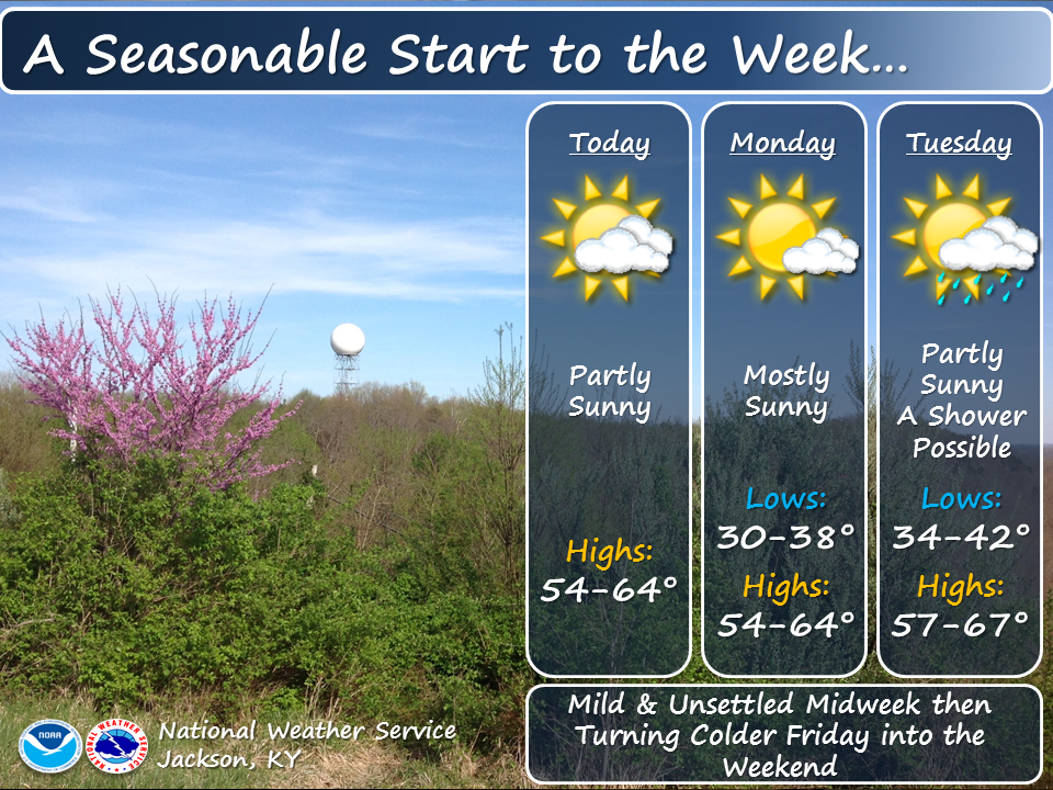
Tropical Depression Two is expected to gradually strengthen and could bring tropical storm conditions to the Florida Panhandle beginning late Monday. Areas of flash flooding will be possible through Thursday along the eastern and central Gulf Coast. Severe thunderstorms will develop and move along a cold front crossing the Upper Midwest Monday, and through the Ohio Valley/Mid-Atlantic on Tuesday. Read More >
Read the Hazardous Weather Outlook (click to read)
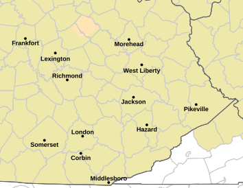
746 FLUS43 KJKL 200109 HWOJKL Hazardous Weather Outlook National Weather Service Jackson KY 909 PM EDT Sun Jul 19 2026 KYZ044-050>052-058>060-068-069-079-080-083>088-104-106>120-201100- Fleming-Montgomery-Bath-Rowan-Estill-Powell-Menifee-Rockcastle- Jackson-Pulaski-Laurel-Wayne-McCreary-Whitley-Knox-Bell-Harlan- Elliott-Morgan-Johnson-Wolfe-Magoffin-Floyd-Lee-Breathitt-Knott- Owsley-Perry-Clay-Leslie-Letcher-Martin-Pike- 909 PM EDT Sun Jul 19 2026 This Hazardous Weather Outlook is for a portion of eastern Kentucky. .DAY ONE...Tonight. No hazardous weather is expected at this time. .DAYS TWO THROUGH SEVEN...Monday through Saturday. A few thunderstorms are possible on Monday afternoon into Monday night, mainly over south central and southeast Kentucky. There is also a potential for thunderstorms at times from Tuesday through Wednesday. Some of the thunderstorms on Tuesday and Tuesday night could be severe, with damaging winds being the main threat. However, tornadoes and large hail can`t be ruled out. Some of the thunderstorms could also bring heavy rainfall on Tuesday and Tuesday night. .SPOTTER INFORMATION STATEMENT... Spotter activation may be needed on Tuesday and Tuesday night. $$ HAL
Read the Area Forecast Discussion (click to read)
521 FXUS63 KJKL 200656 AAC AFDJKL AREA FORECAST DISCUSSION...UPDATED National Weather Service Jackson KY 256 AM EDT Mon Jul 20 2026 .KEY MESSAGES... - A significant cold front could produce multiple rounds of thunderstorms on Tuesday and Tuesday night. Those storms will be capable of severe weather and excessive rainfall. - Mainly dry weather is expected from Wednesday night to Friday with temperatures averaging about 5 degrees below normal. && .UPDATE... Issued at 1107 PM EDT SUN JUL 19 2026 Satellite imagery reveals fog developing in valleys where rain occurred in the southern portion of the forecast area. There are some low clouds present. They appear chaotic and not dominant at this point, but it remains to be seen how things evolve. Have reduced forecast sky cover in the south in the very near term. Temperatures are slower to fall than was forecast (especially in our northeast), and minor adjustments have been made for this, but without altering the morning lows at this point. UPDATE Issued at 903 PM EDT SUN JUL 19 2026 The last of the precip is almost gone, and will fade out shortly. The main question will become the timing and extent of fog development during the night. There is potential for a low cloud deck to affect mainly our southern counties overnight, which would affect fog potential. With light winds in a moist surface air mass beneath dry mid-upper levels, fog is favored should low clouds not inhibit it. && .SHORT TERM...(This evening through Monday night) Issued at 340 PM EDT SUN JUL 19 2026 The latest surface analysis across the CONUS shows a 992 mb surface low over the Canadian Maritimes, with a trailing cold front draped across the Atlantic Seaboard. This cold front is presently moving from north to south through the CWA. Along and ahead of the front, showers and thunderstorms have developed and are slowly moving south. To the north, surface high pressure is starting to build into the northern portions of the area. Temperatures across the CWA range from the mid 80s north of the Mountain Parkway to the lower 80s south of the Mountain Parkway, where thicker cloud cover and precipitation have occurred. Through the remainder of the afternoon, the front will continue to drop south through the region, with showers and thunderstorms remaining present through sunset before dissipating due to waning instability. The environment ahead of the front remains potent for pulse thunderstorms, as upwards of 3000 to 3500 J/kg of SBCAPE exists even with widespread cloud cover. Coupled with 700 to 1000 J/kg of DCAPE and PW values ranging from 1.5 to 2.0 inches, this combination will favor thunderstorms capable of producing heavy rainfall and gusty outflow winds. The primary limiting factor for organized severe weather remains a lack of sufficient wind shear, as effective bulk shear magnitudes are less than 20 knots. Nonetheless, once sunset arrives, convective activity will dissipate. Clearing skies overnight will then favor the development of locally dense river valley fog and in locations that received rainfall Sunday afternoon and evening. Monday brings another day with shower and thunderstorm potential as a potent upper-level trough begins to dive southeastward out of southern Canada. The forecast surface low will move into the northern Great Lakes, lifting a warm front northeastward through the Ohio Valley. As this occurs, Sundays cold front will return northward across the area as a warm front. This will initiate WAA, triggering the development of showers and thunderstorms and allowing temperatures to warm into the mid to upper 80s. Forecast soundings ahead of and behind the lifting front show a gradual change in the thermodynamic profile of Eastern Kentucky. Increasing CAPE and PW values confirm a robust moisture-rich WAA regime entering the region; however, wind shear continues to remain the missing ingredient for organized severe storms. Like Sunday, showers and thunderstorms will dissipate after sunset, giving way to clearing skies and another night of potential for locally dense river valley fog. A cold front moving south through the area today is triggering pulse thunderstorms capable of heavy rain and gusty winds, fueled by high instability but limited by weak wind shear. Activity will diminish after sunset, leading to clearing skies and patchy river valley fog overnight. On Monday, the front lifts back north as a warm front ahead of an incoming Canadian upper-level trough, bringing a return of warmer temperatures, high moisture, and another round of unorganized, afternoon thunderstorms that will fade by Monday night. .LONG TERM...(Tuesday through Sunday) Issued at 340 PM EDT SUN JUL 19 2026 The extended forecast period will start out active as Mondays warm front lifts north through the area, bringing an increase in shower activity overnight Monday into Tuesday morning. Along with the potential for early morning shower and thunderstorm activity, an MCS is forecast to track southeastward toward the CWA from the southern Great Lakes. The 18Z CAMs suite is starting to resolve this feature at the far end of the forecast cycle. Model soundings ahead of the approaching MCS depict a highly potent thermodynamic environment capable of supporting strong to severe thunderstorms, with damaging wind gusts serving as the primary threat. The 12Z NAM forecast sounding reveals MLCAPE values exceeding 2500 J/kg, effective bulk shear around 50 knots, and ESRH values near 175 m2/s2. Additionally, 0 to 3 km shear vectors of approximately 30 knots oriented orthogonal to the forecast UDCZ indicate that the MCS will propagate into an environment highly favorable for maintaining convective organization, where damaging wind signatures and brief spin-up tornadoes are possible. However, uncertainty remains due to meager low and mid-level lapse rates, which may act as a limiting factor for deeper updraft acceleration. As well as, the potential for ongoing shower and thunderstorm activity that could overwork the atmosphere and atmospheric recovery doesnt occur. Nonetheless, the area is under a SPC Day 3 Enhanced Risk for much of the area and areas not in the Enhanced area are in the Slight Risk category. In addition to the severe weather risk, an elevated hydrologic threat is forecast to develop. The southern flank of the MCS is expected to become the focus for training thunderstorms. Deep moisture will be in place with forecast precipitable water (PW) values exceeding 2.00 inches. This exceptional moisture profile will support highly efficient rainfall rates over already saturated soils, increasing the risk for flash flooding. Furthermore, ensemble probabilities indicate that integrated water vapor transport will approach the 99th percentile of climatology. In collaboration with the Weather Prediction Center, the Day 3 Slight Risk Excess Rainfall Outlook has been expanded to encompass the entirety of the JKL CWA. As the forecast MCS and the actual cold frontal squall line exit the area through the day Wednesday, surface high pressure will gradually build into the region. This will usher in a period of dry weather and slightly below seasonal temperatures through late Friday afternoon. Extended guidance then suggests that the next low pressure system will bring a return of shower and thunderstorm chances beginning late Friday evening and persisting through the remainder of the weekend. The extended period opens with a high-impact weather setup as a potent MCS and cold frontal squall line moves into an unstable, highly sheared environment on Tuesday. This system brings a distinct threat of damaging winds, brief tornadoes, and flash flooding. A cold front cleans out the area Tuesday night, introducing a cooler and drier high-pressure regime from Wednesday through Friday afternoon before another storm system brings renewed rain chances for the weekend. && .AVIATION...(For the 06Z TAFS through 06Z Monday night) ISSUED AT 235 AM EDT MON JUL 20 2026 At issuance time, a mixture of low clouds/stratus as well as fog was over the south near a stalled boundary while further north valley fog had formed and there also a few passing low and mid clouds there as well. In some areas the fog and or stratus was resulting in IFR or lower reductions. Further fog and or stratus development during the first 6 hours of the period is the main aviation concern. South of a KJKL to KSJS line, recent trends and guidance support reductions to near or below airport mins for a few hours through 14Z with KSME and KLOZ expected to be affected. KSJS and KJKL should eventually have MVFR to IFR reductions as fog lifts into those areas. At this point, VFR is expected to remain throughout the entire period for KSYM and KIOB. Fog and any low clouds should dissipate between 12Z and 15Z, giving way to prevailing VFR conditions through the remainder of the period. With the boundary lingering over the area isolated to scattered showers and storms may affect locations generally south of a KSME to KLOZ to KJKL to KLOZ line after 16Z. Winds will be light and variable outside of any storms. && .JKL WATCHES/WARNINGS/ADVISORIES... None. && $$ UPDATE...HAL SHORT TERM...VORST LONG TERM...VORST AVIATION...JP |
||||||||||||||