|
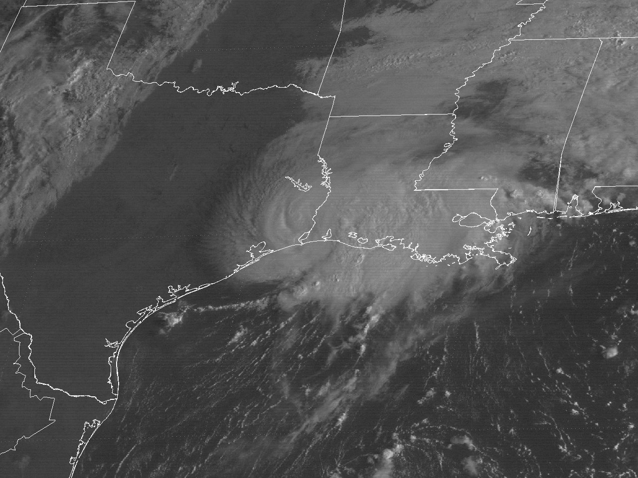
Above: GOES-5 visible satellite image of Tropical Storm Chris at 8:30 AM CDT September 11, 1982, shortly after landfall just east of Sabine Pass, TX.
Tropical Storm Chris had its origin from an upper level low pressure system that developed across the Northeast Gulf on September 6th as it drifted westward. An Air Force reconnaissance flight, ship and buoy reports indicated a surface low had developed the evening of September 8th. The low was designated a subtropical depression due to the broad radius of maximum winds and the surface low remaining underneath the upper level low. During the evening of September 9th, the upper level over the subtropical depression gradually filled, with satellite imagery showing more convection near the center. Post seasonal analysis shows the subtropical depression acquired full tropical characteristics and was designated a tropical depression the evening of September 9th.
An approaching longwave mid to upper level trough over the Western United States with a mid to upper level high over the Southeast United States and Eastern Gulf turned Chris abruptly to the north by daybreak on September 10th. Later that morning, Air Force reconnaissance aircraft, increasing winds on offshore oil rigs, and increasing banding on the WSR-57 radars from the National Weather Service in Galveston, TX and Lake Charles, LA indicated that Tropical Storm Chris had formed about 175 miles south of Sabine Pass, TX.
Tropical Storm Chris continued to steadily strengthen as it headed slightly right of due north towards the Southeast Texas and Southwest Louisiana coast. The center of Tropical Storm Chris made landfall across the Louisiana coast about 7 miles east of Sabine Pass, Texas around 6:00 AM CDT September 11th with maximum sustained winds of 65 mph (55 knots) and a minimum sea level pressure of 994 millibars (29.35 inches). National Weather Service Galveston, TX WSR-57 radar photograph at 7:27 AM CDT, and GOES-5 visible satellite image at 7:30 AM CDT September 11th shows Tropical Storm Chris shortly after landfall just east of Sabine Pass, Texas.
Chris continued to track to the north-northeast after landfall, steadily weakening, and was downgraded to a tropical depression near Natchitoches, Louisiana the evening of September 11th. Tropical Depression Chris continued northeast across Arkansas and dissipated just east of Little Rock by the afternoon of September 12th. Click here for an interactive track of Tropical Storm Chris.
WIND & PRESSURE:
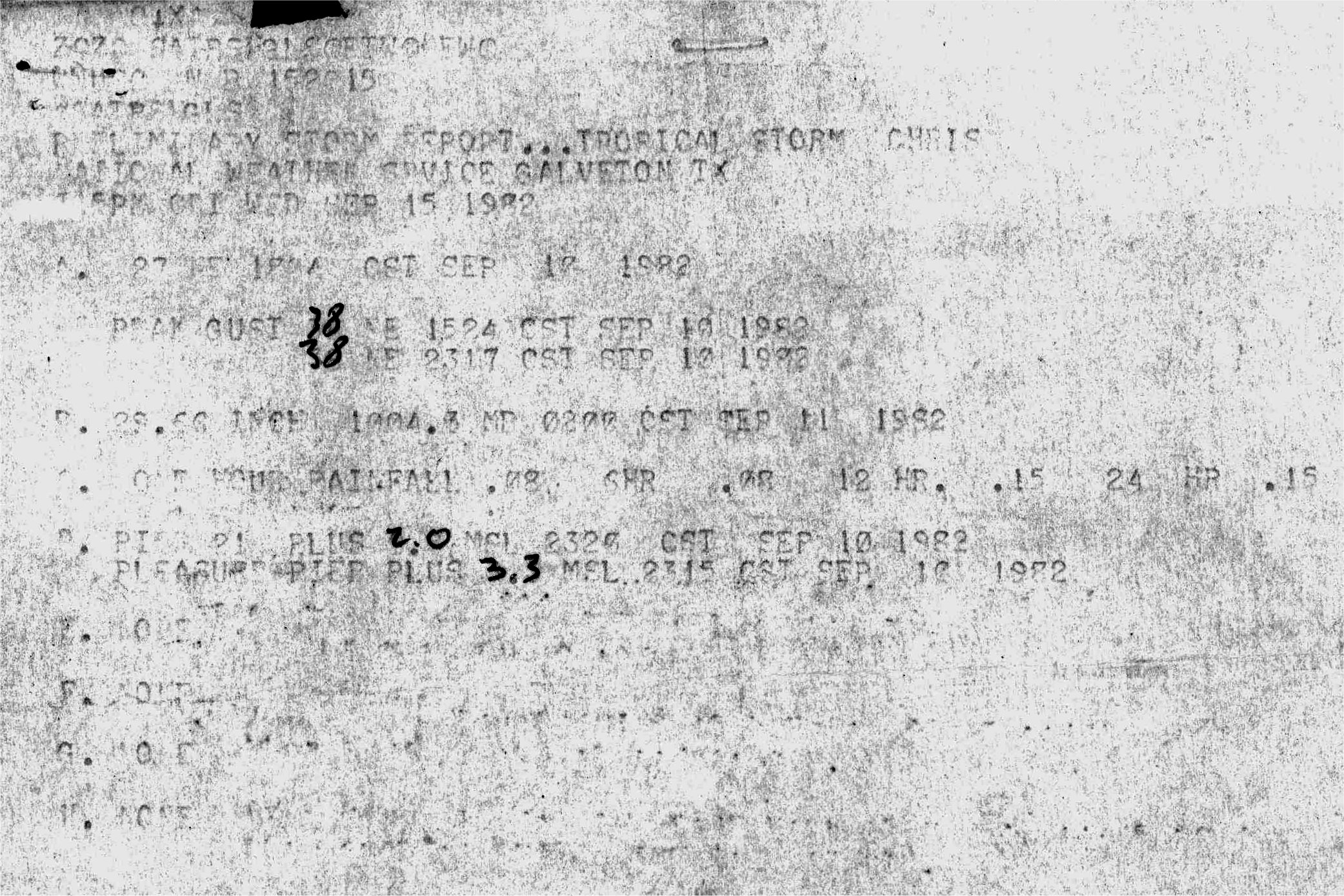
Tropical storm force winds occurred near and east of the track across extreme Southeast Texas, Southern and Central Louisiana. The National Weather Service Lake Charles, Louisiana recorded a maximum sustained wind of 39 mph (34 knots) and a peak wind gust of 60 mph (52 knots), along with a minimum sea level pressure of 1000.3 millibars (29.54 inches) between 9 and 10 AM CDT September 11th. Reliable estimate of gusts to 75 mph (64 knots) was reported near Johnsons Bayou, Louisiana. A peak wind gust of 52 mph (45 knots) occurred at Sea Rim State Park, Texas, and 49 mph (43 knots) at Sabine Pass, TX. The National Weather Service Port Arthur, Texas recorded a maximum sustained wind of 36 mph (31 knots) and a peak wind gust of 45 mph (39 knots), along with a minimum sea level pressure of 1000.6 millibars (29.55 inches) between 6 and 7 AM CDT September 11th. For complete meteorological statistics, see the Wind and Pressure section.
Wind damage caused approximately $200,000 in damage to a restaurant on Pleasure Island in Port Arthur, Texas. Power outages reported for all of Cameron Parish, with more sporadic power outages reported further inland across Southwest Louisiana and Southeast Texas.
STORM SURGE:
Post storm high water mark surveys detailed in the Post Storm Reconnaissance of Tropical Storm Chris publication showed storm surge values of 3 to 4 feet NGVD29 occurred across Jefferson County from Sea Rim State Park to Sabine Pass, Texas. Between Sabine Pass, Texas to Cameron, Louisiana, high water marks between 4 to 6 feet NGVD29 were found. The highest watermark of 9.5 feet NGVD29 was found on a camp near Peveto Beach, Louisiana, but this mark was not specified if it was protected from wave run-up or from an interior location. For other storm surge and high-water marks, see the Storm Surge section.
Considerable storm surge flooding occurred across Cameron Parish. Four miles of Highway 82 along the Gulf between Holly Beach and Johnsons Bayou, Louisiana eroded due to the storm surge and wave action. Six beach camps were destroyed and 15 heavily damaged due to the storm surge and winds. Damage estimate near $500,000 not including road and erosion damage. Across coastal Jefferson County in Southeast Texas, storm surge flooding occurred at Sabine Pass, Texas, with no beach erosion noted.
RAINFALL:
Most of the thunderstorms associated with Tropical Storm Chris occurred along and east of the center, with rainfall of an inch or less occurring across Southeast Texas. Much higher rainfall occurred across Central and Southern Louisiana ranging from 2 to nearly 10 inches. The highest official total of 7.54 inches was recorded from a National Weather Service Cooperative Weather Observer in Eunice, Louisiana. The highest un-official total of 9.95 inches was measured at KVPI radio station in Ville Platte, Louisiana. The highest storm total occurred northeast of our region across Northeast Louisiana near Delhi with over 16 inches. For complete rainfall totals reported across our region, see the Rainfall section.
TORNADOES:
Several tornadoes occurred across Louisiana associated with Tropical Storm Chris. Across our region, three F2 tornadoes were reported between 10 and 11 PM CDT September 11th in Jefferson Davis Parish near Roanoke, Louisiana; in Avoyelles Parish near Moreauville, Louisiana; and Evangeline Parish near Vidrine, Louisiana. Total damages estimated to be a little over 500,000 dollars. A stronger F3 tornado occurred around 1:45 AM CDT September 12th in Concordia Parish near Clayton, Louisiana, causing approximately 250,000 dollars in damage. Fortunately, no deaths or injuries were reported. For complete details on all the tornadoes reported in Louisiana, see the Tornadoes section.
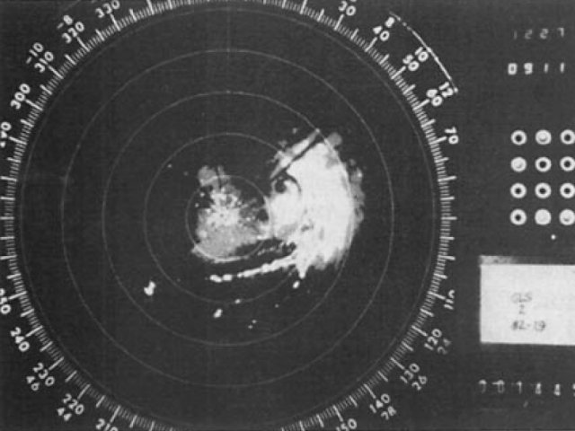
Above: NWS Galveston, TX WSR-57 radar photograph at 7:27 AM CDT September 11, 1982, shortly after landfall just east of Sabine Pass, TX.
|


