National Weather Service United States Department of Commerce
Click a location below for detailed forecast.

Last Map Update: Sat, Aug 2, 2025 at 3:20:20 am CDT

There are no watches, warnings, or advisories at this time.

A surface frontal system will move into a very moist air mass by the afternoon. This should allow for scattered to widespread showers and thunderstorms to develop. Some of the storms will produce frequent cloud to ground lightning and torrential downpours.
Showers and thunderstorms that develop will have the potential to produce torrential downpours with high rainfall rates in a short period of time. This will increase the localized risk for flash flooding. There is a Marginal Risk (level 1 out of 5) Potential for flash flooding or between a 5 and 14 percent chance.
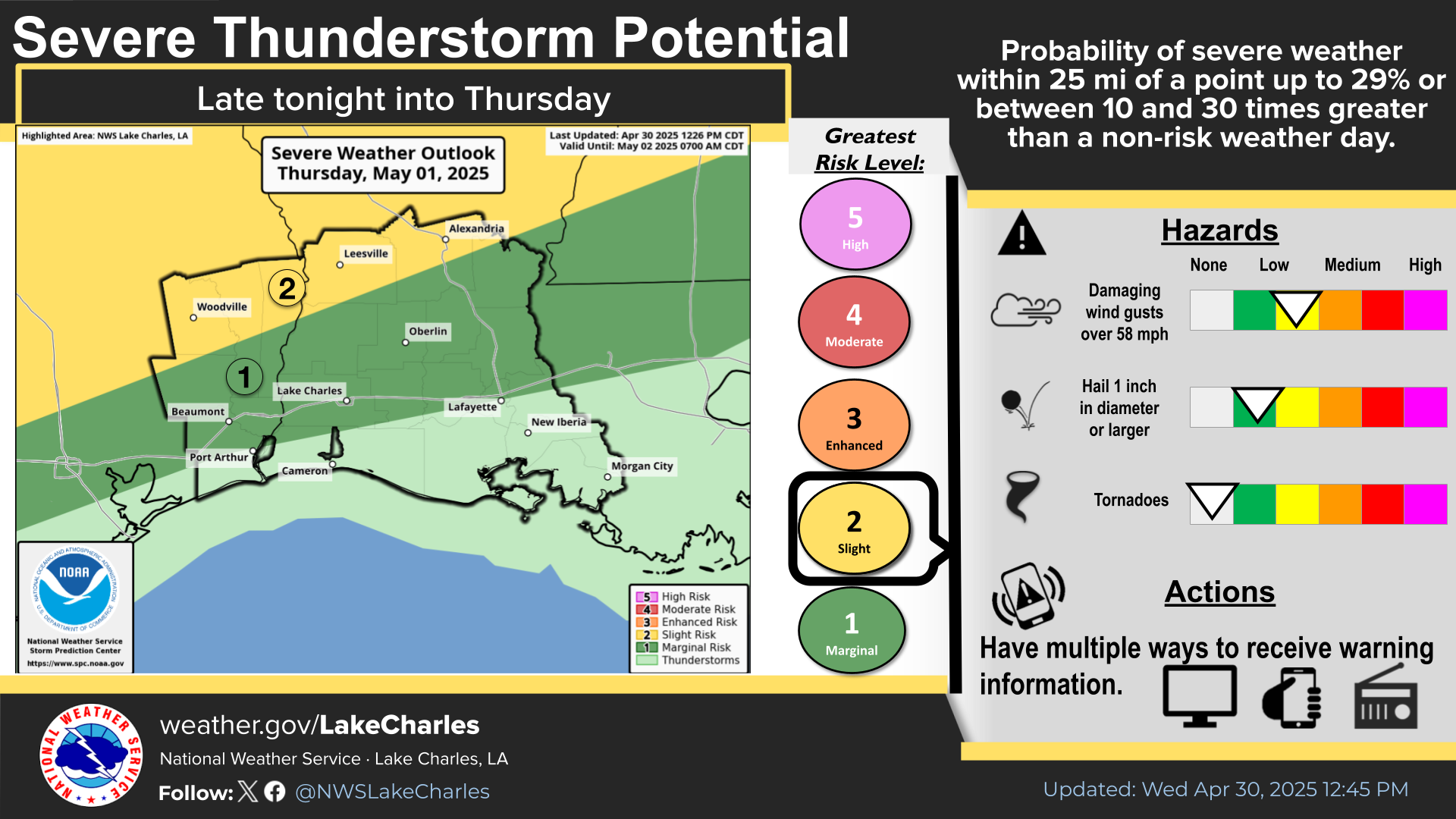
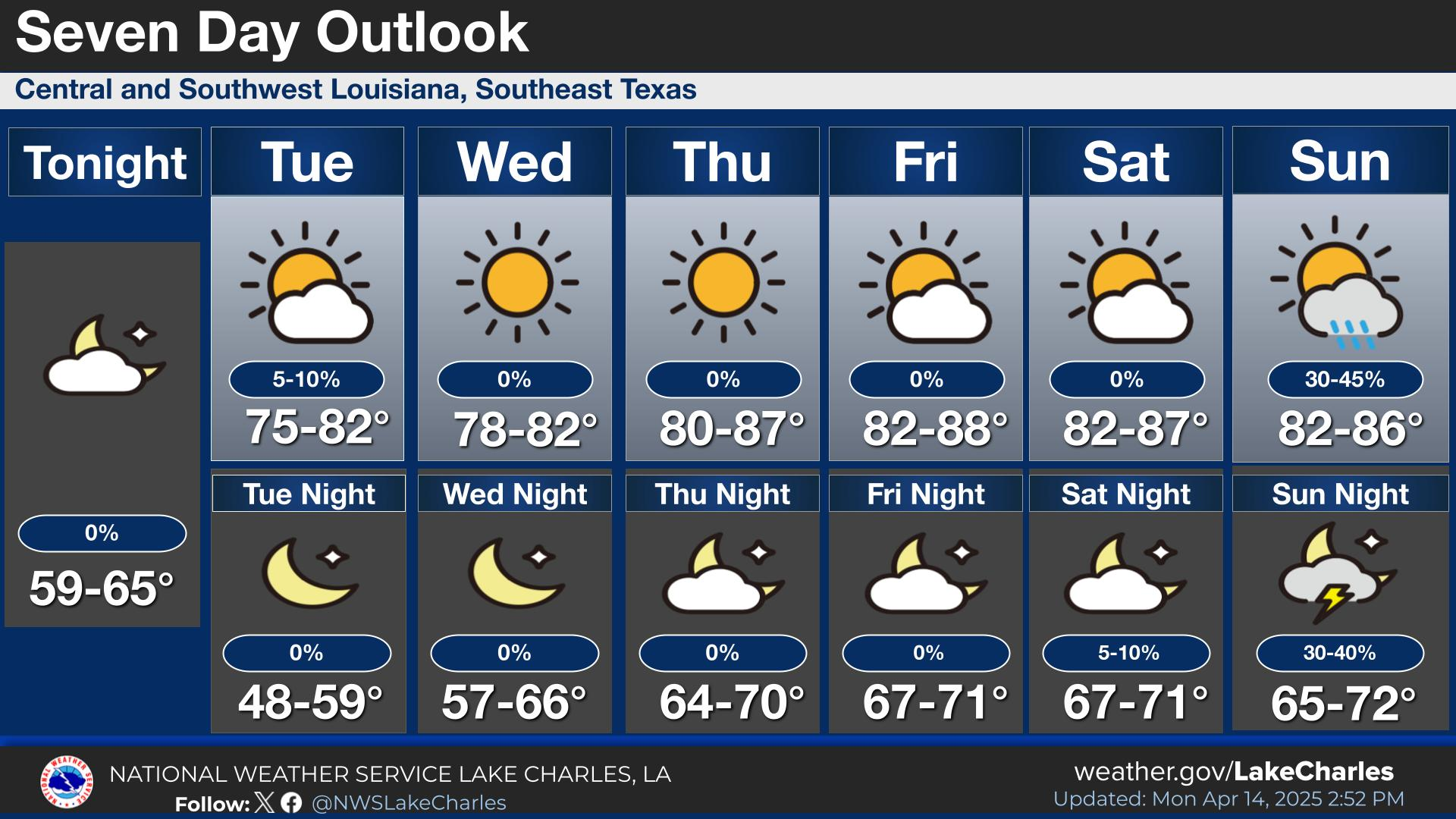
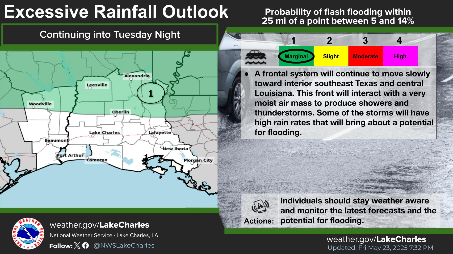
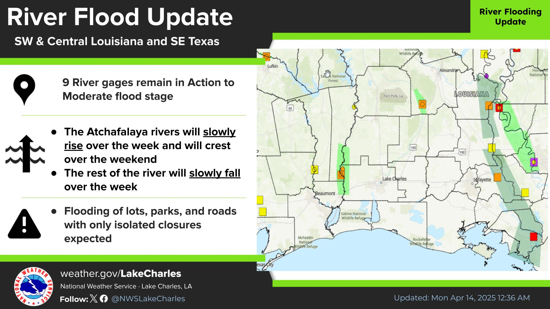
A very moist air mass along with an upper-level disturbance and an approach of a surface frontal boundary will bring about the potential for heavy rainfall that may lead to localized flash flooding through Saturday Night. Forecast rainfall amounts are between 1/2 and 1 inch. The reasonably highest rainfall amounts are roughly between 1 and 4 inches. Remember there is a 10 percent chance that these rainfall amounts may be even higher. If these rainfall amounts fall in a short period of time or over the same location for a prolonged period of the time, the risk for flash flooding will increase.
Here is a quick look at the next 5 days for the region. High rain chances continue into Saturday. Some slightly drier air will reach the region on Sunday with lower rain chances into Sunday before rain chances increase again early next week.

Latest Text Product Selector
 
 
Hourly Weather Roundup ( )
Location Sky/Weather Temp Dewpt RH Wind Baro Remarks
Lake Charles
N/A
N/A
N/A
N/A
N/A
N/A
N/A
Abbeville
N/A
N/A
N/A
N/A
N/A
N/A
N/A
Alexandria
N/A
N/A
N/A
N/A
N/A
N/A
N/A
Beaumont
N/A
N/A
N/A
N/A
N/A
N/A
N/A
De Quincy
N/A
N/A
N/A
N/A
N/A
N/A
N/A
De Ridder
N/A
N/A
N/A
N/A
N/A
N/A
N/A
Fort Polk
N/A
N/A
N/A
N/A
N/A
N/A
N/A
Jasper
N/A
N/A
N/A
N/A
N/A
N/A
N/A
Jennings
N/A
N/A
N/A
N/A
N/A
N/A
N/A
Lafayette
N/A
N/A
N/A
N/A
N/A
N/A
N/A
Nederland/Port Arthur
N/A
N/A
N/A
N/A
N/A
N/A
N/A
New Iberia
N/A
N/A
N/A
N/A
N/A
N/A
N/A
Oakdale
N/A
N/A
N/A
N/A
N/A
N/A
N/A
Opelousas
N/A
N/A
N/A
N/A
N/A
N/A
N/A
Orange
N/A
N/A
N/A
N/A
N/A
N/A
N/A
Patterson
N/A
N/A
N/A
N/A
N/A
N/A
N/A
Pineville
N/A
N/A
N/A
N/A
N/A
N/A
N/A
Sulphur/Carlyss
N/A
N/A
N/A
N/A
N/A
N/A
N/A
"N/A" or "MISG" will be displayed if values are not available. In the LOCATION column, click on links for a list of recent observations at sites of interest. In the WIND column, VRB is "variable" and G is "gust". Wind speeds are in MPH. In the BARO (pressure) column, values are in inches. In the REMARKS column, HX is "heat index", WCI is "wind chill index", and VSB is "visibility" (if shown).
 

Current Weather
 
Rivers & Lakes
 
Forecast Maps
 
Hour By Hour Forecast
 
Tropical Weather
 
Marine Forecast
 
Text Bulletins
 
Forecast Discussion
 
NOAA Weather Radio
 
Submit Storm Report