National Weather Service United States Department of Commerce
Click a location below for detailed forecast.

Last Map Update: Fri, Apr 24, 2026 at 4:26:33 pm CDT

There are no watches, warnings, or advisories at this time.

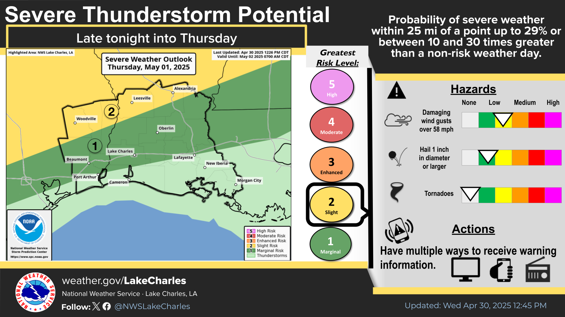
There is a Slight Risk (level 2 of 5) for severe weather for parts of interior SETX and CenLA, with a Marginal Risk for severe weather south of there down to the coast. There will be two opportunities for severe storms. First around the afternoon to evening hours, then again overnight into Saturday. Upper level ridging will keep rain chances low, with mainly a few afternoon showers or storms. Conditions will be humid with temperatures around 5 to 10 degrees above normal. Afternoon highs expected to get into the 90s in some areas.
If an expected squall line can reach the forecast area later today into night, there is a Slight Risk (level 2 of 5) and Marginal Risk (level 1 of 5) for severe weather, mainly damaging winds and/or large hail. This still remains highly conditional and there is low confidence that a squall line does make it into the forecast area.
If a line of storms can reach the forecast area, there is a chance of seeing damaging winds and large hail.
A rather warm and humid period with a chance for showers and thunderstorms today and Saturday. Rain chances will lower on Sunday and Monday with hot and humid conditions prevailing thereafter.
The chance for showers and thunderstorms will continue through Saturday with little to no chances thereafter.
Drought conditions persist across the area, with a slight expansion of moderate to severe drought conditions across Acadiana this week. Drought is favored to persist through the remainder of April, though seasonal outlooks show some improvement possible afterwards through July.

Latest Text Product Selector
 
 
Hourly Weather Roundup ( )
Location Sky/Weather Temp Dewpt RH Wind Baro Remarks
Lake Charles
N/A
N/A
N/A
N/A
N/A
N/A
N/A
Abbeville
N/A
N/A
N/A
N/A
N/A
N/A
N/A
Alexandria
N/A
N/A
N/A
N/A
N/A
N/A
N/A
Beaumont
N/A
N/A
N/A
N/A
N/A
N/A
N/A
De Quincy
N/A
N/A
N/A
N/A
N/A
N/A
N/A
De Ridder
N/A
N/A
N/A
N/A
N/A
N/A
N/A
Fort Polk
N/A
N/A
N/A
N/A
N/A
N/A
N/A
Jasper
N/A
N/A
N/A
N/A
N/A
N/A
N/A
Jennings
N/A
N/A
N/A
N/A
N/A
N/A
N/A
Lafayette
N/A
N/A
N/A
N/A
N/A
N/A
N/A
Nederland/Port Arthur
N/A
N/A
N/A
N/A
N/A
N/A
N/A
New Iberia
N/A
N/A
N/A
N/A
N/A
N/A
N/A
Oakdale
N/A
N/A
N/A
N/A
N/A
N/A
N/A
Opelousas
N/A
N/A
N/A
N/A
N/A
N/A
N/A
Orange
N/A
N/A
N/A
N/A
N/A
N/A
N/A
Patterson
N/A
N/A
N/A
N/A
N/A
N/A
N/A
Pineville
N/A
N/A
N/A
N/A
N/A
N/A
N/A
Sulphur/Carlyss
N/A
N/A
N/A
N/A
N/A
N/A
N/A
"N/A" or "MISG" will be displayed if values are not available. In the LOCATION column, click on links for a list of recent observations at sites of interest. In the WIND column, VRB is "variable" and G is "gust". Wind speeds are in MPH. In the BARO (pressure) column, values are in inches. In the REMARKS column, HX is "heat index", WCI is "wind chill index", and VSB is "visibility" (if shown).
 

Current Weather
 
Rivers & Lakes
 
Forecast Maps
 
Hour By Hour Forecast
 
Tropical Weather
 
Marine Forecast
 
Text Bulletins
 
Forecast Discussion
 
NOAA Weather Radio
 
Submit Storm Report