
Dangerous heat will expand from the Gulf Coast into the Southern Plains and Desert Southwest through week's end. Additional extreme heat impacting the Pacific Northwest will shift to the northern Plains by the weekend. Tropical Storm Bertha is expected to continue to impact portions of the northern Gulf Coast from the western Florida Panhandle to southeastern Louisiana through tonight. Read More >
Overview
|
Fast Facts:
|
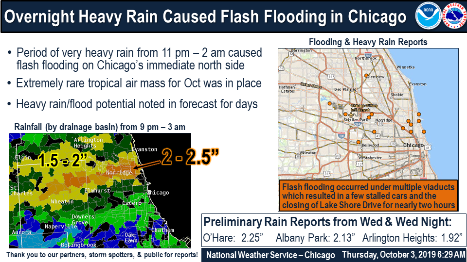 Event Summary |
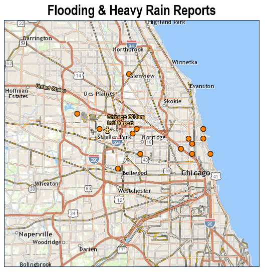
Flooding & Heavy Rain Reports
 |
| Storm Reports |
PRELIMINARY LOCAL STORM REPORT
NATIONAL WEATHER SERVICE CHICAGO IL
437 AM CDT THU OCT 3 2019

..TIME...   ...EVENT...      ...CITY LOCATION...     ...LAT.LON...
..DATE...   ....MAG....      ..COUNTY LOCATION..ST.. ...SOURCE....
            ..REMARKS..

1238 AM     FLASH FLOOD      4N CHICAGO              41.96N 87.65W
10/03/2019                   COOK               IL   LAW ENFORCEMENT

            WATER SEVERAL FEET DEEP AT LAKE SHORE DRIVE
            AND MONTROSE, RESULTING IN THE CLOSURE OF
            LAKE SHORE DRIVE FOR A SEVERAL MILE STRETCH.
            MULTIPLE VEHICLES STUCK IN WATER.

1245 AM     FLASH FLOOD      4N CHICAGO              41.98N 87.65W
10/03/2019                   COOK               IL   LAW ENFORCEMENT

            MULTIPLE VIADUCTS FLOODED, WITH SOME
            VEHICLES THAT ENDED UP STRANDED. THIS
            INCLUDED LAKE SHORE DRIVE AND FOSTER.

1245 AM     FLASH FLOOD      3N CHICAGO              41.93N 87.63W
10/03/2019                   COOK               IL   LAW ENFORCEMENT

            MULTIPLE VIADUCTS FLOODED, WITH SOME
            VEHICLES THAT ENDED UP STRANDED. THIS
            INCLUDED LAKE SHORE DRIVE AND FULLERTON.

1255 AM     FLASH FLOOD      ELMWOOD PARK            41.93N 87.82W
10/03/2019                   COOK               IL   PUBLIC

            TWO TO THREE FEET OF WATER ON A ROADWAY IN
            TOWN.

0136 AM     FLOOD            1 NNW LOGAN SQUARE      41.94N 87.71W
10/03/2019                   COOK               IL   PUBLIC

            WATER OF NEAR A FOOT DEEP ON THE SHOULDER OF
            INTERSTATE 90/94 (KENNEDY EXPRESSWAY) ON THE
            NORTHWEST SIDE OF CHICAGO.

0145 AM     FLASH FLOOD      1 E LOGAN SQUARE        41.93N 87.68W
10/03/2019                   COOK               IL   PUBLIC

            FOUR FEET OF WATER NEAR THE INTERSECTION OF
            FULLERTON AND ELSTON. ONE VEHICLE STUCK.

0200 AM     FLOOD            STONE PARK              41.90N 87.88W
10/03/2019                   COOK               IL   PUBLIC

            ADDISON CREEK OUT OF ITS BANKS. TIME
            ESTIMATED.

0200 AM     HEAVY RAIN       ELK GROVE VILLAGE       42.01N 87.99W
10/03/2019  E2.29 INCH       COOK               IL   PUBLIC

            REPORTED IN 90 MINUTES.

0400 AM     HEAVY RAIN       CHICAGO OHARE AIRPORT   41.98N 87.93W
10/03/2019  M2.14 INCH       DUPAGE             IL   ASOS

            TOTAL FOR WEDNESDAY NIGHT AND EARLY THURSDAY
            MORNING.

0400 AM     HEAVY RAIN       1 W NORRIDGE            41.97N 87.84W
10/03/2019  M2.07 INCH       COOK               IL   MESONET

            MESONET STATION. TOTAL FOR WEDNESDAY NIGHT
            AND EARLY THURSDAY MORNING.

0400 AM     HEAVY RAIN       2 E ALBANY PARK         41.96N 87.69W
10/03/2019  M2.08 INCH       COOK               IL   MESONET

            MESONET STATION. TOTAL FOR WEDNESDAY NIGHT
            AND EARLY THURSDAY MORNING.

0400 AM     HEAVY RAIN       2 WNW GLENVIEW          42.09N 87.85W
10/03/2019  M2.12 INCH       COOK               IL   MESONET

            MESONET STATION. TOTAL FOR WEDNESDAY NIGHT
            AND EARLY THURSDAY MORNING.

0400 AM     HEAVY RAIN       2 WNW LAKEVIEW          41.95N 87.68W
10/03/2019  M2.17 INCH       COOK               IL   MESONET

            MESONET STATION. TOTAL FOR WEDNESDAY NIGHT
            AND EARLY THURSDAY MORNING.

0400 AM     HEAVY RAIN       1 N NORRIDGE            41.98N 87.83W
10/03/2019  M2.19 INCH       COOK               IL   MESONET

            MESONET STATION. TOTAL FOR WEDNESDAY NIGHT
            AND EARLY THURSDAY MORNING.
.
Rainfall Amounts
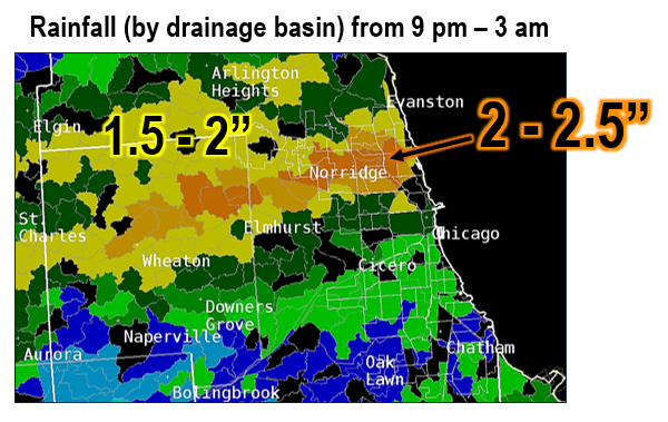 |
| Rainfall |
Public Information Statement...CORRECTED
National Weather Service Chicago IL
454 AM CDT Thu Oct 3 2019 /554 AM EDT Thu Oct 3 2019/

...PRELIMINARY RAINFALL REPORTS FROM THE PAST 24 HOURS...

Most of the higher rainfall totals saw the heaviest rainfall
occur in a very short amount of time, primarily between 11 pm and
2 am last night.

Observations are collected from a variety of sources with varying
equipment and exposures. We thank all volunteer weather observers
for their dedication. Not all data listed are considered official.

Location                     Amount     Provider
------------------------------------------------
Oak Lawn                     2.59 in    MESONET
1 WNW Glenview               2.43 in    MESONET
Chicago O`Hare               2.24 in    ASOS
1 E Albany Park              2.13 in    MESONET
Streamwood                   2.08 in    MESONET
2 S Jefferson Park           2.06 in    MESONET
Hebron                       2.04 in    HADS
1 SSE Carol Stream           1.95 in    MESONET
Wheaton                      1.93 in    MESONET
Glendale Heights             1.93 in    MESONET
Roscoe                       1.90 in    MESONET
Glenview                     1.87 in    MESONET
West Chicago                 1.85 in    MESONET
DeKalb Airport               1.85 in    AWOS
Schaumburg Airport           1.84 in    AWOS
Rosemont                     1.80 in    MESONET
Albany Park                  1.70 in    MESONET
Lincoln Park                 1.69 in    MESONET
2 NNE Carol Stream           1.64 in    MESONET
1 WNW Logan Square           1.64 in    MESONET
Sycamore                     1.62 in    MESONET
Wheaton                      1.61 in    MESONET
Waukegan Airport             1.61 in    AWOS
Skokie                       1.60 in    MESONET
Lakeview                     1.59 in    MESONET
Wilmette                     1.57 in    MESONET
Batavia                      1.56 in    MESONET
1 WSW Albany Park            1.55 in    MESONET
1 NNW Navy Pier              1.54 in    MESONET
Winnetka                     1.54 in    MESONET
Wheaton                      1.53 in    MESONET
West Chicago - DuPage Arpt.  1.53 in    ASOS
Elgin                        1.51 in    MESONET
Glenview                     1.49 in    MESONET
Harvard                      1.47 in    MESONET
1 SW Hoffman Estates         1.47 in    MESONET
River Grove                  1.46 in    MESONET
West Chicago                 1.44 in    MESONET
Roselle                      1.43 in    MESONET
Morton Grove                 1.37 in    MESONET
Sugar Grove - Aurora Arpt.   1.36 in    ASOS
Dixon                        1.35 in    MESONET
Poplar Grove                 1.35 in    MESONET
Kenilworth                   1.35 in    MESONET
Oak Park                     1.34 in    MESONET
Dixon                        1.33 in    MESONET
Chicago                      1.31 in    MESONET
Sycamore                     1.29 in    MESONET
Lakeview                     1.25 in    MESONET
Wheaton                      1.25 in    MESONET
Geneva                       1.24 in    MESONET
Sycamore                     1.23 in    MESONET
Aurora                       1.22 in    MESONET
Batavia                      1.22 in    MESONET
Winnetka                     1.21 in    MESONET
Winnetka                     1.21 in    MESONET
Elburn                       1.20 in    MESONET
Chicago                      1.20 in    MESONET
Chicago                      1.20 in    MESONET
Westmont                     1.19 in    MESONET
Wheaton                      1.19 in    MESONET
Rochelle Airport             1.19 in    AWOS
Wheaton                      1.19 in    MESONET
Wheeling - Chicago Exec. Arp 1.18 in    ASOS
Geneva                       1.17 in    MESONET
Naperville                   1.16 in    MESONET
Geneva                       1.16 in    MESONET
Aurora                       1.15 in    MESONET
Johnsburg                    1.15 in    MESONET
Geneva                       1.15 in    MESONET
Glenwood                     1.13 in    MESONET
Lombard                      1.12 in    MESONET
Geneva                       1.11 in    MESONET
Lisle                        1.10 in    MESONET
2 S Glen Ellyn               1.07 in    MESONET
Woodridge                    1.06 in    MESONET
Flossmoor                    1.06 in    MESONET
Elburn                       1.03 in    MESONET
Richmond                     1.02 in    MESONET
1 NNE Evanston               1.00 in    MESONET
Additional Info
 |
Media use of NWS Web News Stories is encouraged! Please acknowledge the NWS as the source of any news information accessed from this site. Additional recaps can be found on the NWS Chicago Past Events Page |
|

