
Scattered thunderstorms with severe gusts, hail and a tornado risk are possible near a cold front from the Ohio Valley to the Mid-Atlantic tonight. Tropical Storm Bertha is expected to bring tropical storm conditions to portions of the Gulf Coast from the panhandle of Florida into Louisiana through Wednesday. Read More >
Overview
|
Fast Facts:
|
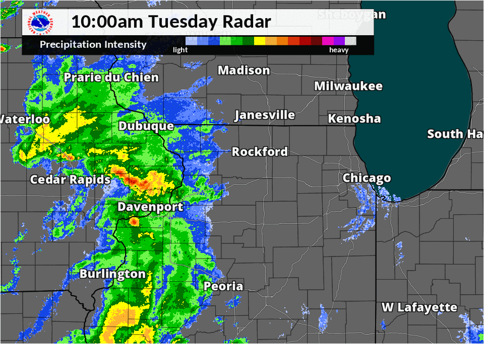 Radar loop from 10am - 8pm CDT August 7th, 2018. |
Rainfall
 |
Public Information Statement
National Weather Service Chicago IL
1042 AM CDT Wed Aug 08 2018
...Morning Rainfall Roundup...
The following are rain amounts for the previous 24-hours
as measured in the morning by NWS Cooperative Observers
and CoCoRaHS observers.
Observations are usually taken between 6 AND 8 AM.
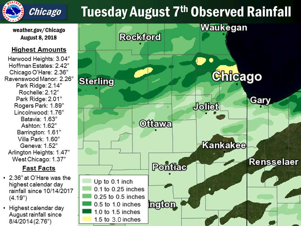
24-hour rainfall amounts
for Wednesday(08/08/18)...
Illinois Rain
Location (County): fall (inches)
Harwood Heights (Cook).......................3.04
Hoffman Estates 5W (Cook)....................2.42
Ohare (Cook).................................2.36
Ravenswood Manor (Cook)......................2.26
Park Ridge (Cook)............................2.14
Rochelle (Ogle)..............................2.12
Park Ridge 1WNW (Cook).......................2.01
Rogers Park 2SW (Cook).......................1.89
Rochelle (Ogle)..............................1.88
Lincolnwood 2E (Cook)........................1.76
Batavia (Kane)...............................1.63
Ashton (Lee).................................1.62
Barrington (Lake)............................1.61
Villa Park 1NW (Du Page).....................1.60
Geneva 1SSW (Kane)...........................1.52
Arlington Heights 1SW (Cook).................1.47
Batavia 2WNW (Kane)..........................1.46
Batavia 1WNW (Kane)..........................1.39
Arlington Heights 1SW (Cook).................1.38
West Chicago (Du Page).......................1.37
Elgin (Kane).................................1.33
Elmwood Park 1ESE (Cook).....................1.32
Dixon 3NNW (Lee).............................1.32
Elgin (Kane).................................1.24
Elgin 1S (Kane)..............................1.24
Geneva 4WSW (Kane)...........................1.21
Elburn (Kane)................................1.20
Elk Grove Village 2WSW (Cook)................1.20
Elburn (Kane)................................1.20
Schaumburg 2E (Cook).........................1.16
Elburn (Kane)................................1.16
Chicago 6NNE (Cook)..........................1.13
Elmhurst (Du Page)...........................1.12
Lily Lake 2E (Kane)..........................1.08
Arlington Heights 3SSW (Cook)................1.07
Palatine 1NNE (Cook).........................1.06
Elmhurst 1ESE (Du Page)......................1.04
Carol Stream (Du Page).......................1.00
Elgin 2W (Kane)..............................0.98
Sugar Grove 1ENE (Kane)......................0.95
Palos Park 4WNW (Cook).......................0.88
Sugar Grove 1NE (Kane).......................0.85
Steward (Lee)................................0.85
Fox Lake 2SE (Lake)..........................0.84
Gilberts (Kane)..............................0.83
De Kalb (De Kalb)............................0.82
Genoa (De Kalb)..............................0.80
Bannockburn (Lake)...........................0.79
Paw Paw (Lee)................................0.79
North Aurora 2NE (Kane)......................0.77
Willow Springs (Cook)........................0.75
Chicago 6ESE (Cook)..........................0.74
De Kalb (De Kalb)............................0.72
Lake Zurich (Lake)...........................0.72
Wheaton 2NNE (Du Page).......................0.71
St. Charles 6NW (Kane).......................0.71
Glencoe (Cook)...............................0.70
Wonder Lake 1WNW (McHenry)...................0.69
Wheeling (Cook)..............................0.69
Oak Park 1NNE (Cook).........................0.67
Botanic Gardens (Cook).......................0.65
Peotone (Will)...............................0.65
Winnetka 1ESE (Cook).........................0.64
Lakemoor 2SE (Lake)..........................0.64
Glen Ellyn 1NNW (Du Page)....................0.63
Midway (Cook)................................0.63
Libertyville 2ESE (Lake).....................0.62
Romeoville (Will)............................0.62
Chicago 5NE (Cook)...........................0.61
Riverwoods (Lake)............................0.61
Joliet 3WNW (Will)...........................0.60
Amboy (Lee)..................................0.58
Lake Zurich 1N (Lake)........................0.57
Buffalo Grove 2N (Lake)......................0.55
Winthrop Harbor 1SSW (Lake)..................0.54
Woodstock 5nw (McHenry)......................0.53
Capron (Boone)...............................0.51
De Kalb 1SW (De Kalb)........................0.51
Lake Bluff 1W (Lake).........................0.51
Highwood 1S (Lake)...........................0.51
Mundelein 2WNW (Lake)........................0.51
Dixon (Lee)..................................0.50
Bridgeview 1NNW (Cook).......................0.50
Algonquin 1N (McHenry).......................0.49
Cary (McHenry)...............................0.46
Lombard 1NNW (Du Page).......................0.44
Dekalb (De Kalb).............................0.43
Oak Park 2S (Cook)...........................0.43
Naperville 2ESE (Du Page)....................0.41
Mundelein (Lake).............................0.41
Huntley (McHenry)............................0.38
Glen Ellyn 1WSW (Du Page)....................0.37
Lake in the Hills 2.5W (McHenry).............0.37
Mundelein (Lake).............................0.37
Oak Park 1SW (Cook)..........................0.34
McHenry (McHenry)............................0.34
Rockford 3NE (Winnebago).....................0.33
Aurora (Kane)................................0.32
Lisle Morton Arb (Du Page)...................0.31
Aurora 4NE (Du Page).........................0.30
Lake Villa 2WSW (Lake).......................0.30
Midway Coop (Cook)...........................0.30
Waukegan (Lake)..............................0.30
Bull Valley 2WNW (McHenry)...................0.29
Romeoville (Will)............................0.28
Countryside 1ENE (Cook)......................0.27
Woodstock 4SW (McHenry)......................0.27
Aurora (Kane)................................0.25
Midlothian (Cook)............................0.25
Downers Grove 0.4NNE (Du Page)...............0.25
Rockford 2ENE (Winnebago)....................0.24
Crystal Lake 1WSW (McHenry)..................0.23
Byron 3N (Ogle)..............................0.23
Lakemoor 2NW (McHenry).......................0.22
Rockford 1NW (Winnebago).....................0.22
Joliet 2n (Will).............................0.22
Rockford (Winnebago).........................0.20
Indiana Rain
Location (County): fall (inches)
Porter 1S (Porter)...........................0.70
Chesterton 4E (Porter).......................0.62
Hammond 1SSW (Lake)..........................0.25
Portage 3E (Porter)..........................0.20
Crown Point (Lake)...........................0.18
Crown Point 1N (Lake)........................0.18
De Motte 1SSW (Jasper).......................0.17
Hebron 1NE (Porter)..........................0.14
Gary 5ENE (Lake).............................0.13
Valparaiso 6NW (Porter)......................0.11
Griffith 1N (Lake)...........................0.10
Valparaiso 4SW (Porter)......................0.10
Portage 1ESE (Porter)........................0.10
Valparaiso 6WSW (Porter).....................0.10
$$
Public Information Statement
National Weather Service Chicago IL
539 AM CDT Wed Aug 8 2018 /639 AM EDT Wed Aug 8 2018/

...TUESDAY AUGUST 7TH PRELIMINARY RAINFALL REPORTS...

ASOS:

Location                     Amount
------------------------------------
Chicago O`Hare*              2.36 in
West Chicago-DuPage Airport  1.37 in
Wheeling-Chi Exec Airport    0.69 in
Chicago Midway               0.62 in

Observations below are collected from a variety of sources with
varying equipment and exposures. We thank all volunteer weather
observers for their dedication. Not all data listed are considered
official.

Location                     Amount     Provider
------------------------------------------------
Schiller Park                2.43 in    HADS
1 ESE Addison                2.01 in    HADS
Rochelle Airport             1.85 in    AWOS
2 WNW Saint Charles          1.38 in    COOP
2 W Batavia                  1.31 in    HADS
1 SW Hanover Park            1.24 in    HADS
Villa Park                   1.21 in    HADS
1 N Elgin                    1.20 in    HADS
1 SE Schaumburg              1.10 in    HADS
1 NNE Wheaton                0.70 in    HADS
|
Flooding Reports
PRELIMINARY LOCAL STORM REPORT...SUMMARY
NATIONAL WEATHER SERVICE CHICAGO/ROMEOVILLE IL
646 PM CDT TUE AUG 7 2018

..TIME...   ...EVENT...      ...CITY LOCATION...     ...LAT.LON...
..DATE...   ....MAG....      ..COUNTY LOCATION..ST.. ...SOURCE....
            ..REMARKS..

0500 PM     HEAVY RAIN       1 E LINCOLNWOOD         42.01N 87.71W
08/07/2018  M1.76 INCH       COOK               IL   COCORAHS

            1.76 INCHES IN AN HOUR. RAIN HAS TAPERED TO DRIZZLE.

0445 PM     FLASH FLOOD      5 NNW CHICAGO           41.95N 87.67W
08/07/2018                   COOK               IL   EMERGENCY MNGR

            VIADUCT UNDER RAILROAD TRACKS AT IRVING PARK ROAD AND
            RAVENSWOOD FLOODED. CARS STALLED WITH WATER UP TO THEIR
            DOORS. CHICAGO OFFICE OF EMERGENCY MANAGEMENT ALSO
            REPORTS NUMEROUS FLOODED VIADUCTS ACROSS THE NORTH SIDE
            OF THE CITY.

0442 PM     HEAVY RAIN       GLENVIEW                42.08N 87.82W
08/07/2018  M1.50 INCH       COOK               IL   BROADCAST MEDIA

            RAIN FELL IN 45 MINUTES.

0430 PM     FLOOD            NORRIDGE                41.97N 87.82W
08/07/2018                   COOK               IL   LAW ENFORCEMENT

            NORRIDGE THEATRE PARKING LOT FLOODED.

0429 PM     HEAVY RAIN       1 N NORRIDGE            41.98N 87.82W
08/07/2018  M2.63 INCH       COOK               IL   BROADCAST MEDIA

            RAINFALL TOTAL AS OF REPORT TIME. BACK YARDS FLOODED WITH
            SEVERAL INCHES OF STANDING WATER.

0425 PM     FLOOD            ROSEMONT                41.99N 87.87W
08/07/2018                   COOK               IL   LAW ENFORCEMENT

            ROAD CLOSURES IN SOME SUBDIVISIONS DUE TO STANDING WATER
            TO CURB HEIGHT.

0420 PM     FLOOD            SCHILLER PARK           41.96N 87.87W
08/07/2018                   COOK               IL   LAW ENFORCEMENT

            IRVING PARK ROAD AND LAWRENCE AVENUE VIADUCTS UNDER
            RAILROAD TRACKS FLOODED. NUMEROUS STALLED VEHICHLES WHICH
            DROVE INTO WATERS.

0415 PM     HEAVY RAIN       SSW PARK RIDGE          42.01N 87.84W
08/07/2018  M2.12 INCH       COOK               IL   COCORAHS

            2.12 INCHES OF RAINFALL OVER A 45 MINUTE PERIOD.

0410 PM     FLOOD            ELMHURST                41.90N 87.94W
08/07/2018                   DUPAGE             IL   LAW ENFORCEMENT

            PALMER DRIVE VIADUCT UNDER RAILROAD TRACKS FLOODED EAST
            OF DOWNTOWN.

0410 PM     FLOOD            ELMHURST                41.90N 87.94W
08/07/2018                   DUPAGE             IL   LAW ENFORCEMENT

            ROUTE 83 VIADUCT FLOODED UNDER RAILROAD TRACKS BETWEEN
            NORTH AVE AND ST. CHARLES ROAD.

0410 PM     HEAVY RAIN       OHARE AIRPORT           41.98N 87.90W
08/07/2018  M2.18 INCH       COOK               IL   ASOS

            RAIN IN UNDER 1 HOUR. TOTAL IS AS OF 410 PM. HEAVY RAIN
            CONTINUES AS OF REPORT TIME. 0.68 INCHES FELL BETWEEN
            343PM AND 351PM.

0316 PM     FLOOD            ST. CHARLES             41.92N 88.30W
08/07/2018                   KANE               IL   TRAINED SPOTTER

            TWO TO THREE INCHES OF STANDING WATER ON 15TH STREET IN
            ST. CHARLES.

0259 PM     HEAVY RAIN       BATAVIA                 41.85N 88.30W
08/07/2018  M0.64 INCH       KANE               IL   CO-OP OBSERVER

            RAIN FELL IN ABOUT 10 MINUTES.

0245 PM     HEAVY RAIN       7 W ROCHELLE            41.92N 89.20W
08/07/2018  E2.00 INCH       OGLE               IL   FIRE DEPT/RESCUE

            TIME ESTIMATED.

0245 PM     FLOOD            ROCHELLE                41.92N 89.06W
08/07/2018                   OGLE               IL   LAW ENFORCEMENT

            STANDING WATER ESTIMATED A FEW INCHES IN DEPTH IN
            MULTIPLE LOCATIONS AROUND ROCHELLE. POLICE USING
            BARRICADES IN TYPICAL TROUBLE SPOTS.
Additional Info
 |
Media use of NWS Web News Stories is encouraged! Please acknowledge the NWS as the source of any news information accessed from this site. Additional recaps can be found on the NWS Chicago Past Events Page |
|

