
Dangerous heat will expand from the Gulf Coast into the Southern Plains and Desert Southwest through week's end. Additional extreme heat impacting the Pacific Northwest will shift to the northern Plains by the weekend. Tropical Storm Bertha is expected to continue to impact portions of the northern Gulf Coast from the western Florida Panhandle to southeastern Louisiana through tonight. Read More >
Overview
|
Fast Facts:
|
 Summary |
Storm Reports
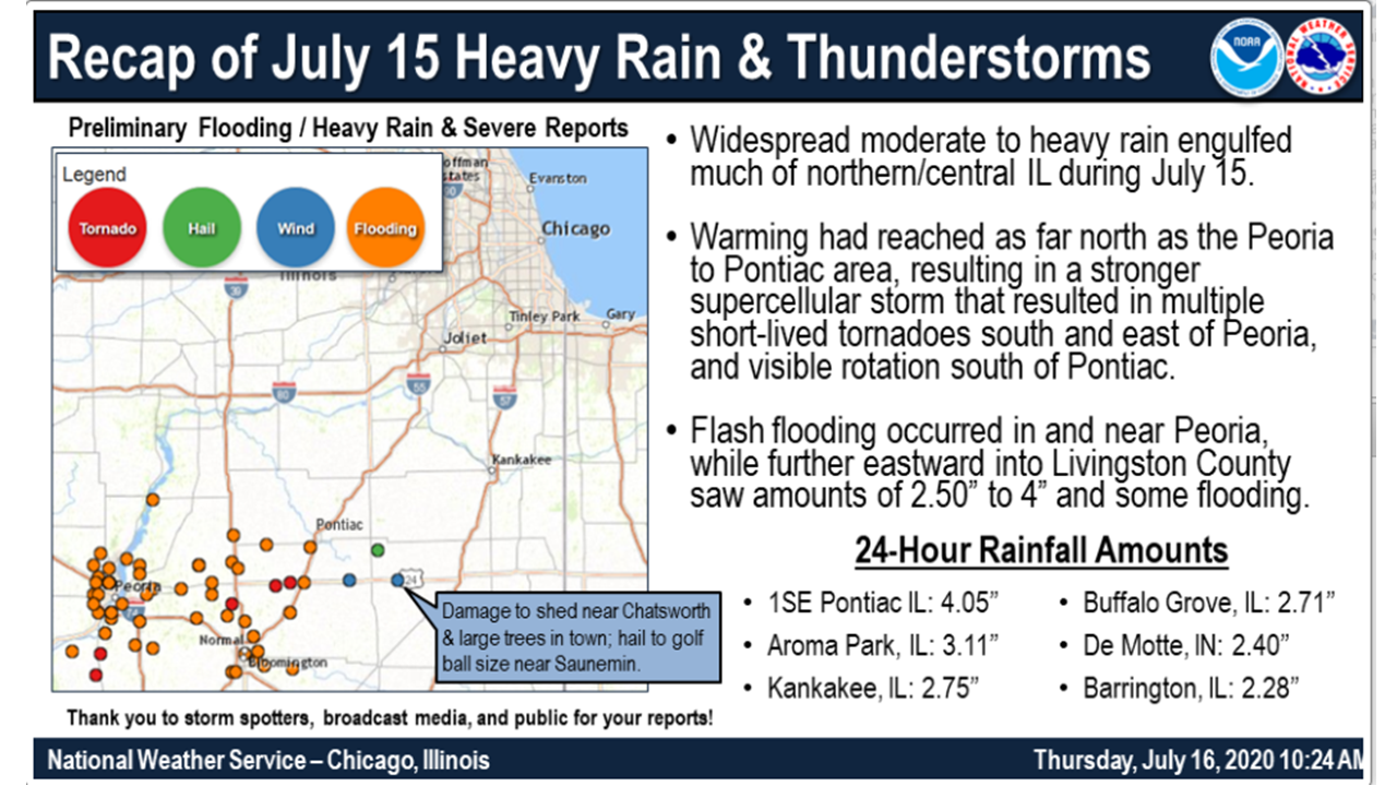
PRELIMINARY LOCAL STORM REPORT...SUMMARY
NATIONAL WEATHER SERVICE CHICAGO IL
1042 AM CDT THU JUL 16 2020

..TIME...   ...EVENT...      ...CITY LOCATION...     ...LAT.LON...
..DATE...   ....MAG....      ..COUNTY LOCATION..ST.. ...SOURCE....
            ..REMARKS..

0444 PM     TSTM WND DMG     FAIRBURY                40.75N 88.51W
07/15/2020                   LIVINGSTON         IL   PUBLIC

            A FEW LARGE LIMBS DOWN IN TOWN. TIME
            ESTIMATED PER RADAR.

0444 PM     HAIL             FAIRBURY                40.75N 88.51W
07/15/2020  M1.00 INCH       LIVINGSTON         IL   TRAINED SPOTTER


0500 PM     HAIL             3 SSE SAUNEMIN          40.85N 88.38W
07/15/2020  E1.75 INCH       LIVINGSTON         IL   TRAINED SPOTTER


0509 PM     HEAVY RAIN       3 WSW PONTIAC           40.86N 88.69W
07/15/2020  M2.20 INCH       LIVINGSTON         IL   PUBLIC

            PRIVATE WEATHER STATION SOUTHWEST OF PONTIAC
            REPORTS 2.2 INCHES STORM TOTAL THUS FAR,
            WITH 1.9 INCHES OCCURRING IN 30 MINUTES.

0510 PM     TSTM WND DMG     CHATSWORTH              40.75N 88.29W
07/15/2020                   LIVINGSTON         IL   CO-OP OBSERVER

            WIDESPREAD WIND DAMAGE IN AND AROUND
            CHATSWORTH. NUMEROUS LARGE TREES DOWN, SHED
            BLOWN DOWN, SHINGLES BLOWN OFF ROOF, BEAN
            FIELD DAMAGED. TIME ESTIMATED BY RADAR.

0514 PM     HAIL             CHATSWORTH              40.75N 88.29W
07/15/2020  E1.00 INCH       LIVINGSTON         IL   CO-OP OBSERVER


0830 PM     FLOOD            2 WSW FLANAGAN          40.87N 88.89W
07/15/2020                   LIVINGSTON         IL   911 CALL CENTER

            SEVERAL REPORTS OF WATER OVER VARIOUS
            INTERSECTIONS ALONG ROUTE 116 NEAR AND WEST
            OF FLANAGAN WITH BARRICADES UP. RELAYED BY
            LIVINGSTON SO.

0700 AM     HEAVY RAIN       3 N AROMA PARK          41.12N 87.80W
07/16/2020  M3.11 INCH       KANKAKEE           IL   COCORAHS

            COCORAHS STATION IL-KK-41 KANKAKEE 3 E
            24-HOUR RAINFALL.

0800 AM     HEAVY RAIN       3 NNE PONTIAC           40.92N 88.62W
07/16/2020  M3.16 INCH       LIVINGSTON         IL   AWOS

            AWOS STATION KPNT PONTIAC AIRPORT 24-HOUR
            RAINFALL.

0800 AM     HEAVY RAIN       3 W IRWIN               41.05N 88.04W
07/16/2020  M2.65 INCH       KANKAKEE           IL   COCORAHS

            COCORAHS STATION IL-KK-39 IRWIN 3 W 24-HOUR
            RAINFALL.

0800 AM     HEAVY RAIN       UNION HILL              41.11N 88.15W
07/16/2020  M2.59 INCH       KANKAKEE           IL   MESONET

            CWOP STATION FW0378 UNION HILL 24-HOUR
            RAINFALL.
Rain Reports
 |
| Rainfall |
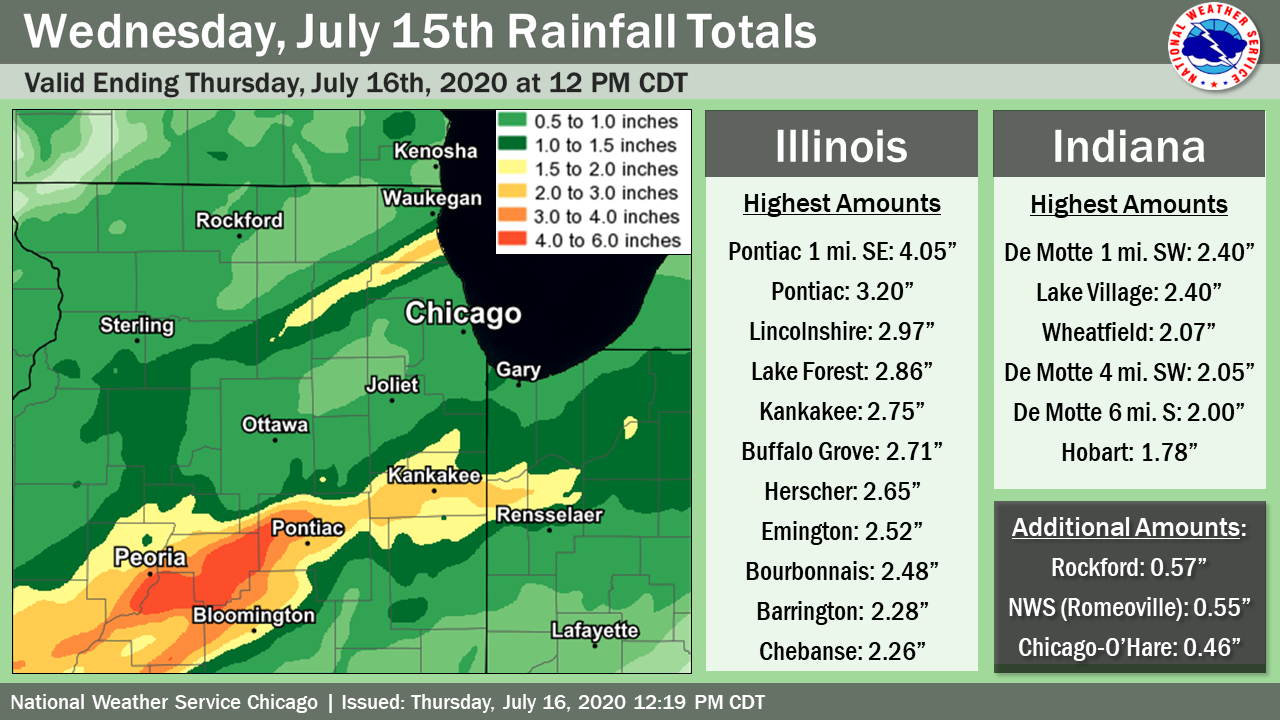
Public Information Statement
National Weather Service Chicago IL
1038 AM CDT Thu Jul 16 2020

...Morning Rainfall Roundup...

   The following are rain amounts for the previous 24-hours
   as measured in the morning by NWS Cooperative Observers
   and CoCoRaHS observers.
   Observations are usually taken between 6 AND 8 AM.

   24-hour rainfall amounts
       for Thursday(07/16/20)...


Illinois                                       Rain
  Location (County):                           fall (inches)

  Pontiac 1SE (Livingston).....................4.05
  Pontiac (Livingston).........................3.20
  Lincolnshire 1N (Lake).......................2.97
  Lake Forest 2NNE (Lake)......................2.86
  Kankakee (Kankakee)..........................2.75
  Buffalo Grove 2N (Lake)......................2.71
  Herscher 3E (Kankakee).......................2.65
  Emington 2SSE (Livingston)...................2.52
  Bourbonnais (Kankakee).......................2.48
  Barrington (Lake)............................2.28
  Chebanse (Kankakee)..........................2.26
  Momence (Kankakee)...........................2.23
  Cortland (De Kalb)...........................2.09
  Lake Zurich (Lake)...........................2.04
  St Anne (Kankakee)...........................1.97
  De Kalb 1SW (De Kalb)........................1.92
  Manteno 2NW (Kankakee).......................1.90
  Elgin (Kane).................................1.88
  Dekalb (De Kalb).............................1.85
  Peotone (Will)...............................1.82
  DeKalb (De Kalb).............................1.77
  Lake Bluff 1W (Lake).........................1.74
  Hoffman Estates 5W (Cook)....................1.73
  Palatine 1NNE (Cook).........................1.70
  Elgin 2W (Kane)..............................1.70
  Elgin 8WSW (Kane)............................1.64
  Elgin (Kane).................................1.63
  Elgin 1S (Kane)..............................1.63
  Monee (Will).................................1.62
  Dwight (Livingston)..........................1.55
  Watseka 6.9WNW (Iroquois)....................1.54
  Highwood 1S (Lake)...........................1.53
  Elburn (Kane)................................1.52
  Ashkum 5.6E (Iroquois).......................1.51
  Buckley (Iroquois)...........................1.45
  Winnetka 1ESE (Cook).........................1.43
  Gilberts (Kane)..............................1.43
  Park Forest (Cook)...........................1.43
  Wilmington 3SE (Will)........................1.42
  Riverwoods (Lake)............................1.41
  Crete 3E (Will)..............................1.41
  Lake Zurich 1N (Lake)........................1.34
  Steward (Lee)................................1.32
  Bannockburn (Lake)...........................1.28
  St. Charles 6NW (Kane).......................1.26
  Amboy (Lee)..................................1.23
  Flossmoor 1ESE (Cook)........................1.23
  Mendota (La Salle)...........................1.21
  Oak Lawn (Cook)..............................1.17
  Geneva 4WSW (Kane)...........................1.14
  Roscoe 2ESE (Winnebago)......................1.14
  Paw Paw (Lee)................................1.14
  Roscoe 2se (Winnebago).......................1.14
  Hoffman Estates 2SE (Cook)...................1.12
  Beecher 3SSE (Will)..........................1.12
  Palatine 1E (Cook)...........................1.11
  Arlington Heights 1SW (Cook).................1.09
  Streamwood 1W (Cook).........................1.08
  St. Charles (Kane)...........................1.07
  Dwight 4NNW (Grundy).........................1.06
  Watseka (Iroquois)...........................1.04
  Chicago 6ESE (Cook)..........................1.02
  New Lenox 3ENE (Will)........................1.02
  Countryside 1ENE (Cook)......................1.01
  Mazon 0.5ENE (Grundy)........................1.00
  Minooka (Grundy).............................1.00
  Midway Coop (Cook)...........................1.00
  Manhattan 2SE (Will).........................0.99
  Arlington Heights 1S (Cook)..................0.98
  Homewood (Cook)..............................0.98
  Morris (Grundy)..............................0.98
  Mokena 1W (Will).............................0.97
  Oak Lawn 2WNW (Cook).........................0.96
  Bartlett 1SE (Du Page).......................0.96
  Mundelein (Lake).............................0.96
  Bridgeview 1NNW (Cook).......................0.95
  Rockford 2ENE (Winnebago)....................0.95
  Manhattan 5ENE (Will)........................0.94
  Morris 2SSE (Grundy).........................0.93
  Homer Glen 1ENE (Will).......................0.93
  Streator (Livingston)........................0.93
  New Lenox 3E (Will)..........................0.92
  Oak Lawn 2SE (Cook)..........................0.90
  Manhattan (Will).............................0.90
  Palos Park 1SW (Cook)........................0.89
  Midlothian (Cook)............................0.88
  Midlothian 1SE (Cook)........................0.88
  Earlville 5NNE (De Kalb).....................0.87
  Geneva 1SSW (Kane)...........................0.87
  Streator 1WSW (La Salle).....................0.87
  Wheeling (Cook)..............................0.87
  Coal City 4NNW (Grundy)......................0.86
  Chicago Ridge (Cook).........................0.86
  Carbon Hill 3.1N (Grundy)....................0.86
  Coal City 3N (Grundy)........................0.86
  Batavia 2WNW (Kane)..........................0.86
  Morris 6ESE (Grundy).........................0.85
  Manhattan 1ESE (Will)........................0.84
  Coal City (Grundy)...........................0.83
  Sterling 4NE (Lee)...........................0.83
  Elwood 5NE (Will)............................0.83
  Park Forest 1NNE (Cook)......................0.82
  Channahon 1NNE (Will)........................0.82
  Lockport 1SE (Will)..........................0.82
  Midway (Cook)................................0.82
  Schaumburg 2E (Cook).........................0.81
  Batavia 1WNW (Kane)..........................0.80
  La Grange Park 1SSW (Cook)...................0.78
  Wilmington 6NW (Will)........................0.78
  Mendota (La Salle)...........................0.78
  Mundelein (Lake).............................0.78
  Chicago 6NNE (Cook)..........................0.77
  Glencoe (Cook)...............................0.77
  Dixon (Lee)..................................0.76
  Flossmoor (Cook).............................0.75
  Morris 5NNW (Grundy).........................0.75
  New Lenox 2SE (Will).........................0.75
  Oak Park 2S (Cook)...........................0.74
  Lansing (Cook)...............................0.73
  Cropsey 1NE (Livingston).....................0.73
  Romeoville (Will)............................0.72
  Aurora (Kane)................................0.71
  Earlville 3S (La Salle)......................0.71
  Genoa (De Kalb)..............................0.71
  Batavia 1WSW (Kane)..........................0.71
  South Beloit 2SE (Winnebago).................0.71
  Cissna Park 1S (Iroquois)....................0.69
  Sugar Grove 1NE (Kane).......................0.69
  Algonquin 1N (McHenry).......................0.69
  Aurora 4NE (Du Page).........................0.68
  Gibson 6NE (Ford)............................0.68
  Dixon 3NNW (Lee).............................0.68
  Channahon 2SSE (Will)........................0.68
  Oak Park 1SW (Cook)..........................0.66
  Burr Ridge 2SW (Du Page).....................0.65
  Paxton (Ford)................................0.64
  Huntley (McHenry)............................0.64
  Joliet 2n (Will).............................0.64
  Brandon Road Lock & Dam (Will)...............0.64
  La Salle (La Salle)..........................0.63
  Elmhurst 2SE (Du Page).......................0.62
  Seneca 1NNE (La Salle).......................0.62
  West Chicago (Du Page).......................0.61
  Lincolnwood 2E (Cook)........................0.61
  Elmhurst (Du Page)...........................0.61
  Lombard 1NNW (Du Page).......................0.61
  North Utica 6N (La Salle)....................0.61
  Elmhurst 1ESE (Du Page)......................0.60
  Crystal Lake 1WSW (McHenry)..................0.60
  Sugar Grove 1ENE (Kane)......................0.59
  Cary (McHenry)...............................0.59
  Plainfield 3ESE (Will).......................0.59
  Aurora (Kane)................................0.58
  Glen Ellyn 1WSW (Du Page)....................0.58
  Zion (Lake)..................................0.58
  Joliet 3WNW (Will)...........................0.58
  Elk Grove Village 2WSW (Cook)................0.57
  Naperville 1NW (Du Page).....................0.57
  Roselle 1ESE (Du Page).......................0.57
  Waukegan 2N (Lake)...........................0.57
  Winthrop Harbor (Lake).......................0.57
  Rockford (Winnebago).........................0.57
  Hebron (McHenry).............................0.56
  Park Ridge 1WNW (Cook).......................0.55
  Oak Park 1NNE (Cook).........................0.55
  Winthrop Harbor 1SSW (Lake)..................0.55
  Romeoville (Will)............................0.55
  Waukegan (Lake)..............................0.55
  Wheaton 2NNE (Du Page).......................0.54
  Lisle Morton Arb (Du Page)...................0.54
  Schaumburg (Du Page).........................0.53
  Gibson 3WNW (Ford)...........................0.53
  Peru 1ENE (La Salle).........................0.53
  Darien 1NNE (Du Page)........................0.52
  Plainfield 5SW (Kendall).....................0.52
  Plainfield 2SSE (Will).......................0.52
  Elk Grove Village 1ESE (Cook)................0.51
  Montgomery 1SSE (Kendall)....................0.51
  Park Ridge (Cook)............................0.50
  Darien (Du Page).............................0.50
  Aurora 4SE (Du Page).........................0.50
  Plano (Kendall)..............................0.50
  Rochelle (Ogle)..............................0.50
  Aurora 4SE (Du Page).........................0.49
  Bolingbrook 3NE (Du Page)....................0.49
  Ottawa 2N (La Salle).........................0.48
  Joliet (Will)................................0.48
  Ottawa (La Salle)............................0.48
  Ottawa 1NW (La Salle)........................0.47
  O`Hare Airport (Cook)........................0.46

Indiana                                        Rain
  Location (County):                           fall (inches)

  De Motte 1SW (Jasper)........................2.40
  Lake Village 2W (Newton).....................2.40
  Wheatfield 5W (Jasper).......................2.07
  De Motte 4SW (Jasper)........................2.05
  De Motte 6S (Jasper).........................2.00
  Wheatfield 4WSW (Jasper).....................1.92
  De Motte 1SSW (Jasper).......................1.90
  Hobart 2E (Lake).............................1.78
  Wheatfield 3S (Jasper).......................1.72
  Lake Village 8SE (Newton)....................1.55
  Rensselaer 10NNE (Jasper)....................1.38
  St. John (Lake)..............................1.24
  Schererville 1E (Lake).......................1.23
  Schererville 2ESE (Lake).....................1.21
  Schererville 1E (Lake).......................1.21
  Morocco (Newton).............................1.16
  Dyer 1WNW (Lake).............................1.15
  Hebron 1NW (Porter)..........................1.11
  Hobart 1SSW (Lake)...........................1.09
  Chesterton 1ENE (Porter).....................1.07
  Valparaiso 2WSW (Porter).....................1.05
  Fair Oaks 6SW (Newton).......................1.03
  Valparaiso 4SW (Porter)......................1.03
  Rensselaer 5NW (Jasper)......................1.00
  Valparaiso 6SSW (Porter).....................1.00
  Munster 2NNW (Lake)..........................0.99
  Porter 1S (Porter)...........................0.99
  Valparaiso (Porter)..........................0.98
  Valparaiso 2WNW (Porter).....................0.95
  Chesterton 4E (Porter).......................0.95
  Rensselaer 8ENE (Jasper).....................0.94
  Valparaiso 1NNW (Porter).....................0.94
  Valparaiso 2NW (Porter)......................0.93
  Valparaiso 2N (Porter).......................0.92
  Mount Ayr 2NNE (Newton)......................0.91
  Portage 3E (Porter)..........................0.85
  Gary 5ENE (Lake).............................0.81
  Rensselaer 2N (Jasper).......................0.78
  Kentland (Newton)............................0.73
  Brook 4W (Newton)............................0.73
  Rensselaer (Jasper)..........................0.70
  Kentland 2SSE (Newton).......................0.61
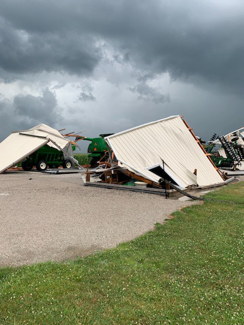
Photos & Additional Info
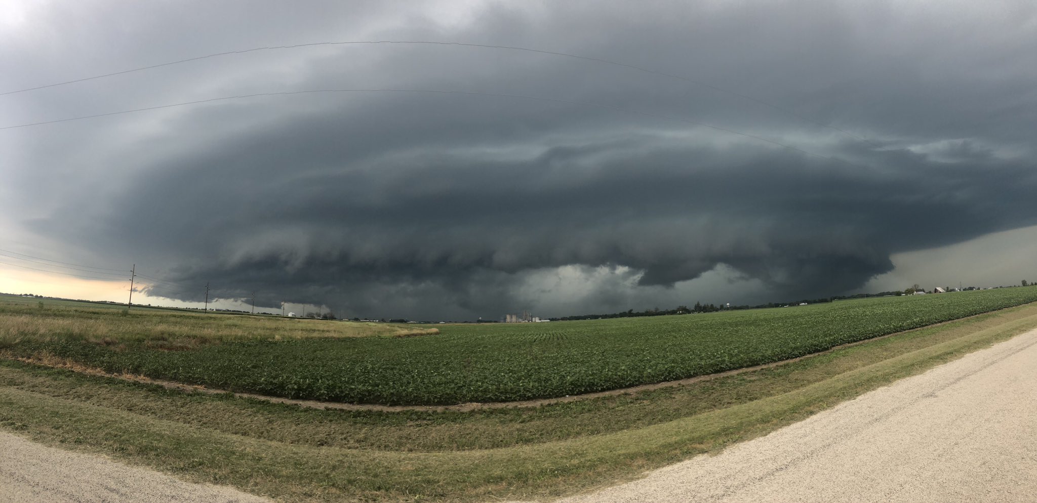 |
 |
| Gilman, IL area (courtesy of Twitter user @dag19013) |
Outside of Chatsworth, IL (relayed by Champaign media outlet WCIA) |
 |
Media use of NWS Web News Stories is encouraged! Please acknowledge the NWS as the source of any news information accessed from this site. Additional recaps can be found on the NWS Chicago Past Events Page |
|

