Overview
|
Two rounds of showers and thunderstorms brought severe weather to parts of northern Illinois on Thursday. The first wave was associated with a cluster of thunderstorms known as a Mesoscale Convective System which moved southward out of Wisconsin during the early-morning hours and continued to track towards the southeast through Thursday morning and into the afternoon. This system brought a swath of isolated wind damage and occasional quarter-sized hail to the region. After a brief lull, additional thunderstorms erupted during the evening hours and tracked generally along I-88 dropping large hail along the I-88 corridor. Hail ranged from the size of quarters to slightly larger than 2" in diameter. |
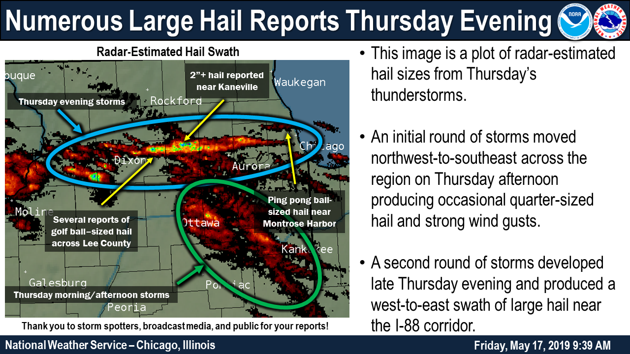 Radar-estimated hail swaths with several ground reports overlaid. |
SPC Mesoanalysis and Radar Animation

Storm Reports
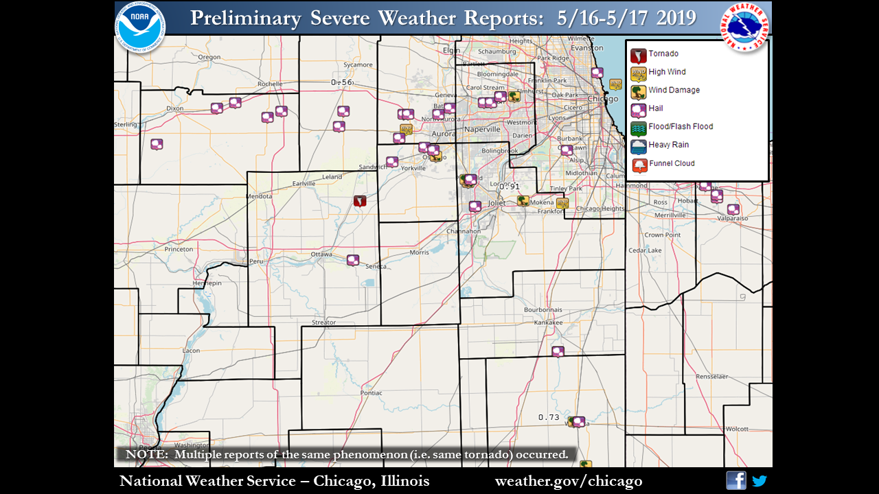 |
| Storm Reports |
PRELIMINARY LOCAL STORM REPORT...SUMMARY
NATIONAL WEATHER SERVICE CHICAGO IL
103 AM CDT FRI MAY 17 2019

..TIME...   ...EVENT...      ...CITY LOCATION...     ...LAT.LON...
..DATE...   ....MAG....      ..COUNTY LOCATION..ST.. ...SOURCE....
            ..REMARKS..

1240 AM     HAIL             GLEN ELLYN              41.88N 88.07W
05/17/2019  M1.00 INCH       DUPAGE             IL   TRAINED SPOTTER


1235 AM     HAIL             GLEN ELLYN              41.88N 88.07W
05/17/2019  M1.00 INCH       DUPAGE             IL   PUBLIC


1234 AM     HAIL             WHEATON                 41.86N 88.11W
05/17/2019  M1.25 INCH       DUPAGE             IL   PUBLIC


1230 AM     HAIL             1 SE WINFIELD           41.86N 88.14W
05/17/2019  M1.50 INCH       DUPAGE             IL   TRAINED SPOTTER


1225 AM     HAIL             1 NW NORTH AURORA       41.82N 88.34W
05/17/2019  E1.00 INCH       KANE               IL   PUBLIC


1222 AM     HAIL             1 ESE BATAVIA           41.84N 88.29W
05/17/2019  M1.25 INCH       KANE               IL   TRAINED SPOTTER


1210 AM     HAIL             3 ESE KANEVILLE         41.82N 88.47W
05/17/2019  E1.50 INCH       KANE               IL   PUBLIC


1202 AM     HAIL             2 SE KANEVILLE          41.82N 88.49W
05/17/2019  M2.50 INCH       KANE               IL   TRAINED SPOTTER

            MEASURED 2.25 INCH DIAMETER HAIL, LOTS OF
            GOLF BALL SIZED HAIL.

1154 PM     HAIL             2 N VALPARAISO          41.50N 87.06W
05/16/2019  M1.50 INCH       PORTER             IN   PUBLIC


1144 PM     HAIL             SOUTH HAVEN             41.55N 87.13W
05/16/2019  E1.00 INCH       PORTER             IN   TRAINED SPOTTER


1141 PM     HAIL             1 SE SOUTH HAVEN        41.54N 87.13W
05/16/2019  E1.00 INCH       PORTER             IN   PUBLIC


1114 PM     HAIL             4 SW STEWARD            41.81N 89.08W
05/16/2019  E1.75 INCH       LEE                IL   TRAINED SPOTTER

            GOLF BALL SIZE ON ROUTE 251, 3 MILES NORTH
            OF ROUTE 30.

1032 PM     HAIL             CHICAGO RIDGE           41.70N 87.78W
05/16/2019  M0.75 INCH       COOK               IL   TRAINED SPOTTER


1019 PM     HAIL             PLANO                   41.66N 88.54W
05/16/2019  M0.75 INCH       KENDALL            IL   TRAINED SPOTTER


1011 PM     HAIL             2 N OSWEGO              41.70N 88.36W
05/16/2019  E0.25 INCH       KENDALL            IL   PUBLIC


1005 PM     HAIL             3 NW OSWEGO             41.71N 88.40W
05/16/2019  E1.75 INCH       KENDALL            IL   PUBLIC


0957 PM     HAIL             3 SE BIG ROCK           41.74N 88.51W
05/16/2019  E1.75 INCH       KANE               IL   TRAINED SPOTTER


0950 PM     HAIL             WATERMAN                41.78N 88.77W
05/16/2019  E1.75 INCH       DE KALB            IL   PUBLIC

            TIME ESTIMATED BY RADAR.

0948 PM     HAIL             1 S STEWARD             41.83N 89.02W
05/16/2019  M1.00 INCH       LEE                IL   TRAINED SPOTTER


0929 PM     HAIL             1 SSE ASHTON            41.86N 89.22W
05/16/2019  M1.75 INCH       LEE                IL   PUBLIC

            I-88 NEAR ASHTON.

0923 PM     HAIL             FRANKLIN GROVE          41.84N 89.30W
05/16/2019  M1.50 INCH       LEE                IL   PUBLIC


&&

$$
Rain Reports
Public Information Statement
National Weather Service Chicago IL
1029 AM CDT Fri May 17 2019

...Morning Rainfall Roundup...

   The following are rain amounts greater than one inch for
   the previous 24-hours as measured in the morning by NWS
   Cooperative Observers and CoCoRaHS observers.
   Observations are usually taken between 6 AND 8 AM.

   24-hour rainfall amounts ending Friday(05/17/19)...


Illinois                                       Rain
  Location (County):                           fall (inches)

  Sterling 4NE (Lee)...........................2.00
  Marseilles Lock & Dam (La Salle).............1.52
  Plano (Kendall)..............................1.45
  Oswego 5SSE (Kendall)........................1.36
  Dwight (Livingston)..........................1.31
  Plainfield 3NNW (Will).......................1.31
  Plainfield 2SSE (Will).......................1.29
  Plainfield (Will)............................1.27
  Flossmoor 1ESE (Cook)........................1.26
  Lansing (Cook)...............................1.24
  Montgomery 1SSE (Kendall)....................1.23
  Steward (Lee)................................1.21
  Dwight 4NNW (Grundy).........................1.19
  Flossmoor (Cook).............................1.18
  Lockport 1SE (Will)..........................1.18
  Park Forest (Cook)...........................1.16
  Lansing (Cook)...............................1.09
  Ashkum 5.6E (Iroquois).......................1.05
  Romeoville (Will)............................1.05
  Batavia 1WSW (Kane)..........................1.04
  Aurora (Kane)................................1.02
  Mokena 1W (Will).............................1.01
  Mazon 0.5ENE (Grundy)........................1.00

Indiana                                        Rain
  Location (County):                           fall (inches)

  Schererville 1E (Lake).......................1.91
  Schererville 1E (Lake).......................1.35
  Winfield 1NE (Lake)..........................1.26
  Crown Point (Lake)...........................1.21
  Crown Point 1N (Lake)........................1.21
  Hebron 4NE (Porter)..........................1.06
  Griffith 1N (Lake)...........................1.02

$$

Additional Info
 |
Media use of NWS Web News Stories is encouraged! Please acknowledge the NWS as the source of any news information accessed from this site. Additional recaps can be found on the NWS Chicago Past Events Page |
|

