
Extreme heat continues today from the central Plains to the lower Mississippi River Valley, over southeast Montana, and from southern California into the Southwest Deserts. Extreme Heat Warnings remain in effect. Severe thunderstorms capable of strong to severe wind gusts and large hail are possible across the Great Lakes into the Ohio Valley today into tonight. Read More >
| This was a long duration event made up of several components, and even sort of two events with the second being just lake effect snow. There was a period of snow on Sunday morning, the 17th, followed by snow and some ice during the afternoon. This led to hazardous travel. For the evening, the precipitation had all transitioned back to snow along and north of I-80, while remained freezing drizzle south. The snow gradually faded during the early morning of Monday the 18th. Lake effect snow showers though developed and persisted into far northeast Illinois and far northwest Indiana into the late afternoon. The longest duration snow was in far northern Illinois where the highest amounts fell. When accounting for the lake effect snow of the 18th, total amounts were highest in Lake County, IL and northern Cook County. |
Fast Facts
Snow Totals
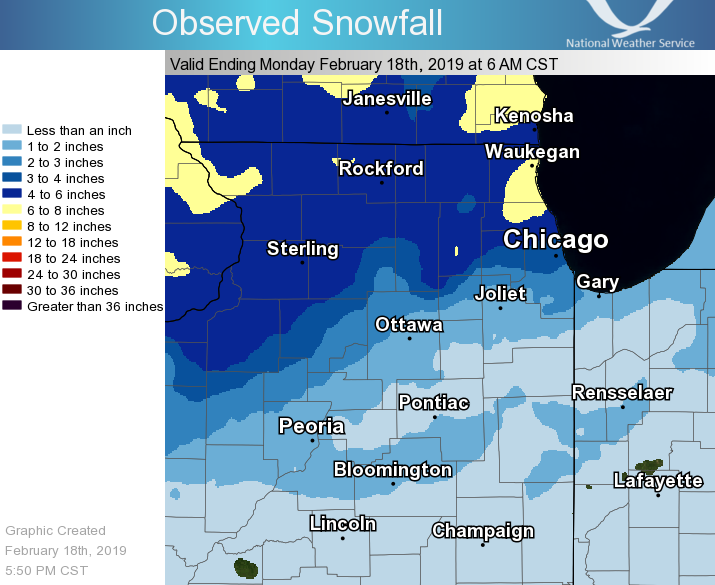 |
Public Information Statement
National Weather Service Chicago IL
1051 AM CST Mon Feb 18 2019

...Storm Total Snowfall...

The following is a list of storm total snowfall amounts
from the early morning on Sunday, February 17th through
around 8 am Monday, February 18th. Most of these totals
encompass two periods of snow, with the first during the
morning of the 17th and the second during the late afternoon
of the 17th into the early morning of the 18th. These totals
do not include additional amounts from lake effect snow near
Lake Michigan during the morning of the 18th.

Location                     Amount

...Illinois...

...Boone County...
Capron                       4.2 in

...Cook County...
Palatine                     7.0 in
Wheeling                     7.0 in
Northbrook                   6.8 in
Hoffman Estates              6.1 in
Chicago Botanic Garden       5.8 in
Barrington                   5.5 in
1 N Medinah                  5.4 in
2 E Schaumburg               5.2 in
Oak Park                     4.7 in
Evanston                     4.5 in
Ohare Airport                4.3 in
2 WSW Rogers Park            4.1 in
3 SW Midway Airport          4.0 in
La Grange Park               3.0 in
Lansing                      1.8 in
Park Forest                  1.5 in

...De Kalb County...
Genoa                        7.9 in
DeKalb                       3.7 in

...DuPage County...
1 W Glen Ellyn               4.5 in
1 SSW Berkeley               3.8 in
2 SE Darien                  2.4 in
4 ESE Aurora                 2.2 in

...Grundy County...
Coal City 4 NNW              1.2 in
Morris 1 NW                  1.0 in

...Iroquois County...
2 N Crescent City            1.0 in

...Kane County...
St. Charles                  6.0 in
3 W Elgin                    5.1 in
Elburn                       5.0 in
Batavia                      4.2 in
Batavia                      4.2 in
Aurora                       3.0 in

...Kankakee County...
Bourbonnais                  1.1 in

...La Salle County...
Mendota                      2.5 in
3 S Earlville                2.5 in
La Salle                     2.4 in
Ottawa - Buffalo Rock SP     1.3 in
Marseilles                   1.0 in

...Lake County...
2 N Buffalo Grove            8.7 in
Riverwoods                   8.2 in
Highwood                     7.8 in
1 SE Grandwood Park          6.6 in
Lake Zurich                  6.0 in
2 N Waukegan                 5.0 in
Libertyville                 4.8 in
Mundelein 4 WSW              4.7 in

...Lee County...
3 NNW Nelson                 5.0 in
Ashton                       4.2 in
Paw Paw 2 S                  2.8 in
Steward                      2.2 in

...Livingston County...
Chatsworth                   1.5 in

...McHenry County...
Woodstock 5 NW               6.1 in
Hebron                       5.8 in
4 SW Woodstock               4.8 in
2 ENE Lakewood               3.4 in

...Ogle County...
Rochelle                     3.2 in

...Will County...
NWS Chicago-Romeoville       1.6 in
Manhattan 5 ENE              1.6 in
Joliet 2 N                   1.4 in

...Winnebago County...
3 WSW Rockford               5.2 in
Roscoe                       5.1 in
Rockford Airport             3.8 in

...Indiana...

...Lake County...
3 NNW Lake Station           1.3 in

...Newton County...
2 NNE Mount Ayr              0.9 in

...Porter County...
Portage                      2.0 in
Ogden Dunes                  1.1 in

Observations are collected from a variety of sources with varying
equipment and exposures. We thank all volunteer weather observers
for their dedication. Not all data listed are considered official.

$$

Kluber
Storm Reports
PRELIMINARY LOCAL STORM REPORT...SUMMARY
NATIONAL WEATHER SERVICE CHICAGO IL
602 PM CST MON FEB 18 2019
..TIME... ...EVENT... ...CITY LOCATION... ...LAT.LON...
..DATE... ....MAG.... ..COUNTY LOCATION..ST.. ...SOURCE....
..REMARKS..
0700 AM SNOW 2 N BUFFALO GROVE 42.19N 87.96W
02/18/2019 M8.7 INCH LAKE IL COCORAHS
30 HOUR STORM TOTAL SNOWFALL OVER TWO
SEPARATE PERIODS OF SNOW. COCORAHS STATION
IL-LK-16, 2 N BUFFALO GROVE.
0700 AM SNOW 1 NE RIVERWOODS 42.17N 87.89W
02/18/2019 M8.2 INCH LAKE IL COCORAHS
30 HOUR STORM TOTAL SNOWFALL OVER TWO
SEPARATE PERIODS OF SNOW. COCORAHS STATION
IL-LK-39, 1 NE RIVERWOODS.
0600 AM SNOW 2 SSW GENOA 42.07N 88.71W
02/18/2019 M7.9 INCH DE KALB IL CO-OP OBSERVER
30 HOUR STORM TOTAL SNOWFALL OVER TWO
SEPARATE PERIODS OF SNOW. CO-OP OBSERVER
STATION GEOI2, GENOA.
0700 AM SNOW HIGHWOOD 42.20N 87.81W
02/18/2019 M7.8 INCH LAKE IL COCORAHS
30 HOUR STORM TOTAL SNOWFALL OVER TWO
SEPARATE PERIODS OF SNOW. COCORAHS STATION
IL-LK-69, HIGHWOOD.
0700 AM SNOW 1 NNE PALATINE 42.13N 88.03W
02/18/2019 M7.0 INCH COOK IL COCORAHS
30 HOUR STORM TOTAL SNOWFALL OVER TWO
SEPARATE PERIODS OF SNOW. COCORAHS STATION
IL-CK-294, 1 NNE PALATINE.
0830 AM SNOW WHEELING 42.13N 87.92W
02/18/2019 M7.0 INCH COOK IL PUBLIC
30 HOUR STORM TOTAL SNOWFALL OVER TWO
SEPARATE PERIODS OF SNOW.
0700 AM SNOW NORTHBROOK 42.13N 87.83W
02/18/2019 M6.8 INCH COOK IL EMERGENCY MNGR
30 HOUR STORM TOTAL SNOWFALL OVER TWO
SEPARATE PERIODS OF SNOW.
0700 AM SNOW 1 SE GRANDWOOD PARK 42.38N 87.97W
02/18/2019 M6.6 INCH LAKE IL COCORAHS
30 HOUR STORM TOTAL SNOWFALL OVER TWO
SEPARATE PERIODS OF SNOW. COCORAHS STATION
IL-LK-42, 1 SE GRANDWOOD PARK.
0700 AM SNOW 5 NW WOODSTOCK 42.36N 88.53W
02/18/2019 M6.1 INCH MCHENRY IL CO-OP OBSERVER
30 HOUR STORM TOTAL SNOWFALL OVER TWO
SEPARATE PERIODS OF SNOW. CO-OP OBSERVER
STATION WODI2, WOODSTOCK 5 NW.
0700 AM SNOW 1 W HOFFMAN ESTATES 42.05N 88.12W
02/18/2019 M6.1 INCH COOK IL COCORAHS
30 HOUR STORM TOTAL SNOWFALL OVER TWO
SEPARATE PERIODS OF SNOW. COCORAHS STATION
IL-CK-278, HOFFMAN ESTATES.
0700 AM SNOW 1 SSW FOREST LAKE 42.19N 88.07W
02/18/2019 M6.0 INCH LAKE IL CO-OP OBSERVER
30 HOUR STORM TOTAL SNOWFALL OVER TWO
SEPARATE PERIODS OF SNOW. CO-OP OBSERVER
STATION LKZI2, LAKE ZURICH.
0800 AM SNOW 1 ENE ST. CHARLES 41.92N 88.30W
02/18/2019 M6.0 INCH KANE IL COCORAHS
30 HOUR STORM TOTAL SNOWFALL OVER TWO
SEPARATE PERIODS OF SNOW. COCORAHS STATION
IL-KN-64, 1 ENE ST. CHARLES.
0700 AM SNOW 2 W HEBRON 42.47N 88.48W
02/18/2019 M5.8 INCH MCHENRY IL CO-OP OBSERVER
30 HOUR STORM TOTAL SNOWFALL OVER TWO
SEPARATE PERIODS OF SNOW. CO-OP OBSERVER
STATION HEBI2, HEBRON.
0800 AM SNOW 1 WNW GLENCOE 42.14N 87.79W
02/18/2019 M5.8 INCH COOK IL CO-OP OBSERVER
30 HOUR STORM TOTAL SNOWFALL OVER TWO
SEPARATE PERIODS OF SNOW. CO-OP OBSERVER
STATION CBGI2, CHICAGO BOTANIC GARDEN.
0800 AM SNOW 2 SSE BARRINGTON HILLS 42.12N 88.16W
02/18/2019 M5.5 INCH COOK IL CO-OP OBSERVER
30 HOUR STORM TOTAL SNOWFALL OVER TWO
SEPARATE PERIODS OF SNOW. CO-OP OBSERVER
STATION BARI2, BARRINGTON.
0630 AM SNOW 1 N MEDINAH 42.00N 88.05W
02/18/2019 M5.4 INCH COOK IL COCORAHS
30 HOUR STORM TOTAL SNOWFALL OVER TWO
SEPARATE PERIODS OF SNOW. COCORAHS STATION
IL-CK-75, 1 N MEDINAH.
0700 AM SNOW 2 E SCHAUMBURG 42.03N 88.04W
02/18/2019 M5.2 INCH COOK IL COCORAHS
30 HOUR STORM TOTAL SNOWFALL OVER TWO
SEPARATE PERIODS OF SNOW. COCORAHS STATION
IL-CK-131, 2 E SCHAUMBURG.
0700 AM SNOW 3 WSW ROCKFORD 42.25N 89.15W
02/18/2019 M5.2 INCH WINNEBAGO IL COCORAHS
30 HOUR STORM TOTAL SNOWFALL OVER TWO
SEPARATE PERIODS OF SNOW. COCORAHS STATION
IL-WN-40, 3 WSW ROCKFORD.
0630 AM SNOW 2 ESE ROSCOE 42.41N 88.98W
02/18/2019 M5.1 INCH WINNEBAGO IL CO-OP OBSERVER
30 HOUR STORM TOTAL SNOWFALL. CO-OP OBSERVER
STATION RSCI2, ROSCOE.
0700 AM SNOW 3 W ELGIN 42.04N 88.34W
02/18/2019 M5.1 INCH KANE IL COCORAHS
30 HOUR STORM TOTAL SNOWFALL OVER TWO
SEPARATE PERIODS OF SNOW. COCORAHS STATION
IL-KN-95, 3 W ELGIN.
0600 AM SNOW 1 S ELBURN 41.87N 88.47W
02/18/2019 M5.0 INCH KANE IL CO-OP OBSERVER
24 HOUR SNOWFALL. CO-OP OBSERVER STATION
ELBI2, ELBURN.
0700 AM SNOW 2 N WAUKEGAN 42.39N 87.84W
02/18/2019 M5.0 INCH LAKE IL COCORAHS
0800 AM SNOW 3 NNW NELSON 41.83N 89.62W
02/18/2019 M5.0 INCH LEE IL COCORAHS
30 HOUR STORM TOTAL SNOWFALL OVER TWO
SEPARATE PERIODS OF SNOW. COCORAHS STATION
IL-LE-5, 3 NNW NELSON.
1200 PM SNOW OHARE AIRPORT 41.98N 87.90W
02/18/2019 M4.9 INCH COOK IL OFFICIAL NWS OBS
STORM TOTAL SNOWFALL. 0.6 INCHES SINCE 6AM.
0730 AM SNOW LIBERTYVILLE 42.28N 87.95W
02/18/2019 M4.8 INCH LAKE IL EMERGENCY MNGR
30 HOUR STORM TOTAL SNOWFALL OVER TWO
SEPARATE PERIODS OF SNOW.
0800 AM SNOW 4 SW WOODSTOCK 42.28N 88.49W
02/18/2019 M4.8 INCH MCHENRY IL COCORAHS
30 HOUR STORM TOTAL SNOWFALL OVER TWO
SEPARATE PERIODS OF SNOW. COCORAHS STATION
IL-MCH-33, 4 SW WOODSTOCK.
0650 AM SNOW 1 NNE OAK PARK 41.91N 87.78W
02/18/2019 M4.7 INCH COOK IL COCORAHS
30 HOUR STORM TOTAL SNOWFALL OVER TWO
SEPARATE PERIODS OF SNOW. COCORAHS STATION
IL-CK-74, 1 NNE OAK PARK.
0700 AM SNOW 3 NNW HAWTHORN WOODS 42.26N 88.08W
02/18/2019 M4.7 INCH LAKE IL CO-OP OBSERVER
30 HOUR STORM TOTAL SNOWFALL OVER TWO
SEPARATE PERIODS OF SNOW. CO-OP OBSERVER
STATION MUNI2, MUNDELEIN 4 WSW.
0645 AM SNOW EVANSTON 42.04N 87.69W
02/18/2019 M4.5 INCH COOK IL TRAINED SPOTTER
0700 AM SNOW 1 W GLEN ELLYN 41.88N 88.09W
02/18/2019 M4.5 INCH DUPAGE IL COCORAHS
30 HOUR STORM TOTAL SNOWFALL OVER TWO
SEPARATE PERIODS OF SNOW. COCORAHS STATION
IL-DP-132, 1 W GLEN ELLYN.
0600 AM SNOW BATAVIA 41.85N 88.31W
02/18/2019 M4.2 INCH KANE IL CO-OP OBSERVER
24 HOUR SNOWFALL. CO-OP OBSERVER STATION
BATI2, BATAVIA.
0600 AM SNOW BATAVIA 41.85N 88.31W
02/18/2019 M4.2 INCH KANE IL CO-OP OBSERVER
24-HOUR TOTAL. PP 0.25.
0700 AM SNOW CAPRON 42.40N 88.74W
02/18/2019 M4.2 INCH BOONE IL COCORAHS
30 HOUR STORM TOTAL SNOWFALL OVER TWO
SEPARATE PERIODS OF SNOW. COCORAHS STATION
IL-BN-14, CAPRON.
0700 AM SNOW ASHTON 41.86N 89.23W
02/18/2019 M4.2 INCH LEE IL COCORAHS
30 HOUR STORM TOTAL SNOWFALL OVER TWO
SEPARATE PERIODS OF SNOW. COCORAHS STATION
IL-LE-8, ASHTON.
0700 AM SNOW 2 WSW ROGERS PARK 42.00N 87.70W
02/18/2019 M4.1 INCH COOK IL COCORAHS
30 HOUR STORM TOTAL SNOWFALL OVER TWO
SEPARATE PERIODS OF SNOW. COCORAHS STATION
IL-CK-94, 2 WSW ROGERS PARK.
1000 AM SNOW 3 SW MIDWAY AIRPORT 41.74N 87.78W
02/18/2019 M4.0 INCH COOK IL CO-OP OBSERVER
STORM TOTAL SNOWFALL. 1.9 INCHES SINCE
MIDNIGHT. 0.22 INCHES STORM TOTAL LIQUID.
0600 AM SNOW ROCKFORD AIRPORT 42.20N 89.10W
02/18/2019 M3.8 INCH WINNEBAGO IL OFFICIAL NWS OBS
UPDATES PREVIOUS SNOW REPORT FROM ROCKFORD
AIRPORT. STORM TOTAL THROUGH 6AM.
0700 AM SNOW 1 W HILLSIDE 41.88N 87.92W
02/18/2019 M3.8 INCH DUPAGE IL COCORAHS
30 HOUR STORM TOTAL SNOWFALL OVER TWO
SEPARATE PERIODS OF SNOW. COCORAHS STATION
IL-DP-117, 1 SSW BERKELEY.
0700 AM SNOW 1 WNW DEKALB 41.93N 88.77W
02/18/2019 M3.7 INCH DE KALB IL CO-OP OBSERVER
30 HOUR STORM TOTAL SNOWFALL OVER TWO
SEPARATE PERIODS OF SNOW. CO-OP OBSERVER
STATION DEKI2, DEKALB.
0600 AM SNOW 3 SW MIDWAY AIRPORT 41.74N 87.78W
02/18/2019 M3.4 INCH COOK IL CO-OP OBSERVER
UPDATES PREVIOUS SNOW REPORT FROM 3 SW
MIDWAY AIRPORT. STORM TOTAL NOW THROUGH 6AM.
0.19 INCHES LIQUID EQUIVALENT.
0700 AM SNOW 2 ENE LAKEWOOD 42.23N 88.35W
02/18/2019 M3.4 INCH MCHENRY IL COCORAHS
30 HOUR STORM TOTAL SNOWFALL OVER TWO
SEPARATE PERIODS OF SNOW. COCORAHS STATION
IL-MCH-83, 2 ENE LAKEWOOD.
0600 AM SNOW 1 S ROCHELLE 41.91N 89.07W
02/18/2019 M3.2 INCH OGLE IL CO-OP OBSERVER
24 HOUR SNOWFALL. CO-OP OBSERVER STATION
RCHI2, ROCHELLE.
0700 AM SNOW 2 N AURORA 41.78N 88.31W
02/18/2019 M3.0 INCH KANE IL CO-OP OBSERVER
30 HOUR STORM TOTAL SNOWFALL OVER TWO
SEPARATE PERIODS OF SNOW. CO-OP OBSERVER
STATION ARRI2, AURORA.
0700 AM SNOW 1 SSW LA GRANGE PARK 41.82N 87.88W
02/18/2019 M3.0 INCH COOK IL COCORAHS
30 HOUR STORM TOTAL SNOWFALL OVER TWO
SEPARATE PERIODS OF SNOW. COCORAHS STATION
IL-CK-98, 1 SSW LA GRANGE PARK.
0700 AM SNOW 2 S PAW PAW 41.67N 88.98W
02/18/2019 M2.8 INCH LEE IL CO-OP OBSERVER
30 HOUR STORM TOTAL SNOWFALL OVER TWO
SEPARATE PERIODS OF SNOW. CO-OP OBSERVER
STATION PAWI2, PAW PAW 2 S.
0600 AM SNOW 3 S EARLVILLE 41.55N 88.91W
02/18/2019 M2.5 INCH LA SALLE IL CO-OP OBSERVER
30 HOUR STORM TOTAL SNOWFALL.
0600 AM SNOW 1 S MENDOTA 41.53N 89.12W
02/18/2019 M2.5 INCH LA SALLE IL CO-OP OBSERVER
30 HOUR STORM TOTAL SNOWFALL OVER TWO
SEPARATE PERIODS OF SNOW. CO-OP OBSERVER
STATION MDTI2, MENDOTA.
0700 AM SNOW 1 NNW LA SALLE 41.34N 89.10W
02/18/2019 M2.4 INCH LA SALLE IL COCORAHS
30 HOUR STORM TOTAL SNOWFALL. COCORAHS
STATION IL-LS-34, LA SALLE.
0715 AM SNOW 2 SE DARIEN 41.73N 87.95W
02/18/2019 M2.4 INCH DUPAGE IL COCORAHS
30 HOUR STORM TOTAL SNOWFALL. COCORAHS
STATION IL-DP-79, 2 SE DARIEN.
0700 AM SNOW 4 ESE AURORA 41.73N 88.24W
02/18/2019 M2.2 INCH DUPAGE IL COCORAHS
30 HOUR STORM TOTAL SNOWFALL. COCORAHS
STATION IL-DP-16, 4 ESE AURORA.
0700 AM SNOW 2 S STEWARD 41.81N 89.02W
02/18/2019 M2.2 INCH LEE IL CO-OP OBSERVER
30 HOUR STORM TOTAL SNOWFALL OVER TWO
SEPARATE PERIODS OF SNOW. CO-OP OBSERVER
STATION STWI2, STEWARD.
1000 AM SNOW PORTAGE 41.58N 87.18W
02/18/2019 M2.0 INCH PORTER IN PUBLIC
STORM TOTAL SNOWFALL.
0700 AM SNOW 1 N LYNWOOD 41.54N 87.54W
02/18/2019 M1.8 INCH COOK IL CO-OP OBSERVER
24 HOUR STORM TOTAL SNOWFALL.
1200 PM SNOW NWS CHICAGO-ROMEOVILLE 41.60N 88.08W
02/18/2019 M1.7 INCH WILL IL OFFICIAL NWS OBS
UPDATES PREVIOUS SNOW REPORT FROM NWS
CHICAGO-ROMEOVILLE. FINAL STORM TOTAL SNOW
THROUGH NOON.
0800 AM SNOW 4 SW FRANKFORT 41.46N 87.91W
02/18/2019 M1.6 INCH WILL IL CO-OP OBSERVER
30 HOUR STORM TOTAL SNOWFALL. CO-OP OBSERVER
STATION MATI2, MANHATTAN 5 ENE.
0700 AM SNOW CHATSWORTH 40.75N 88.29W
02/18/2019 M1.5 INCH LIVINGSTON IL CO-OP OBSERVER
30 HOUR STORM TOTAL SNOWFALL. CO-OP OBSERVER
STATION CHTI2, CHATSWORTH.
0700 AM SNOW 1 NNE PARK FOREST 41.49N 87.68W
02/18/2019 M1.5 INCH COOK IL CO-OP OBSERVER
24 HOUR STORM TOTAL SNOWFALL. CO-OP OBSERVER
STATION PKFI2, PARK FOREST.
0700 AM SNOW CREST HILL 41.55N 88.10W
02/18/2019 M1.4 INCH WILL IL CO-OP OBSERVER
30 HOUR STORM TOTAL SNOWFALL. CO-OP OBSERVER
STATION JKJI2, JOLIET 2 N.
0730 AM SNOW 3 NNW LAKE STATION 41.62N 87.25W
02/18/2019 M1.3 INCH LAKE IN COCORAHS
24 HOUR STORM TOTAL SNOWFALL. STILL SNOWING.
COCORAHS STATION IN-LK-63, 3 NNW LAKE
STATION.
0749 AM SNOW 2 W NAPLATE 41.33N 88.91W
02/18/2019 M1.3 INCH LA SALLE IL CO-OP OBSERVER
30 HOUR STORM TOTAL SNOWFALL. CO-OP OBSERVER
STATION OTTI2, OTTAWA - BUFFALO ROCK SP.
0700 AM SNOW 3 N CARBON HILL 41.34N 88.30W
02/18/2019 M1.2 INCH GRUNDY IL CO-OP OBSERVER
30 HOUR STORM TOTAL SNOWFALL. CO-OP OBSERVER
STATION CTYI2, COAL CITY 4 NNW.
0700 AM SNOW OGDEN DUNES 41.62N 87.20W
02/18/2019 M1.1 INCH PORTER IN COCORAHS
24 HOUR STORM TOTAL SNOWFALL. COCORAHS
STATION IN-PT-157, OGDEN DUNES.
0700 AM SNOW 3 WNW BOURBONNAIS 41.18N 87.94W
02/18/2019 M1.1 INCH KANKAKEE IL CO-OP OBSERVER
30 HOUR STORM TOTAL SNOWFALL. CO-OP OBSERVER
STATION BOUI2, BOURBONNAIS.
0600 AM SNOW 2 N CRESCENT CITY 40.80N 87.86W
02/18/2019 M1.0 INCH IROQUOIS IL COCORAHS
24 HOUR STORM TOTAL SNOWFALL. COCORAHS
STATION IL-IR-14, 2 N CRESCENT CITY.
0600 AM SNOW 2 W MARSEILLES 41.33N 88.75W
02/18/2019 M1.0 INCH LA SALLE IL CO-OP OBSERVER
24 HOUR SNOWFALL. MIXED WITH FREEZING RAIN
DURING THE AFTERNOON OF 2/17. CO-OP OBSERVER
STATION MMOI2, MARSEILLES.
0800 AM SNOW 1 NW MORRIS 41.37N 88.43W
02/18/2019 M1.0 INCH GRUNDY IL CO-OP OBSERVER
24 HOUR STORM TOTAL SNOWFALL. CO-OP OBSERVER
STATION MOSI2, MORRIS 1 NW.
0900 AM SNOW 2 NNE MOUNT AYR 40.97N 87.29W
02/18/2019 M0.9 INCH NEWTON IN COCORAHS
24 HOUR STORM TOTAL SNOWFALL. COCORAHS
STATION IN-NW-1, 2 NNE MOUNT AYR.
 |
Media use of NWS Web News Stories is encouraged! Additional recaps can be found on the NWS Chicago Science & Past Events Page. |
|

