Overview
During the evening hours of June 13, 1976, a few isolated storms developed in northeastern Illinois near the Chicago Metropolitan Area. One of those storms developed into a slow-moving, supercell thunderstorm. This storm produced a tornado starting near Lemont which followed an unusual winding path over the hour to near Darien and Downers Grove. This tornado caused 2 fatalities, 23 injuries, and approximately $13 million ($76 million in 2025) in damages.
In addition to the tornado, the slow movement of the storm caused a significant flash flood event in far southeastern DuPage County and central Cook County. Over 1 hour of nearly continuous hail occurred on the southwest side of Chicago.
Tornadoes & Hail
Lemont-Argonne Tornado
 |
||
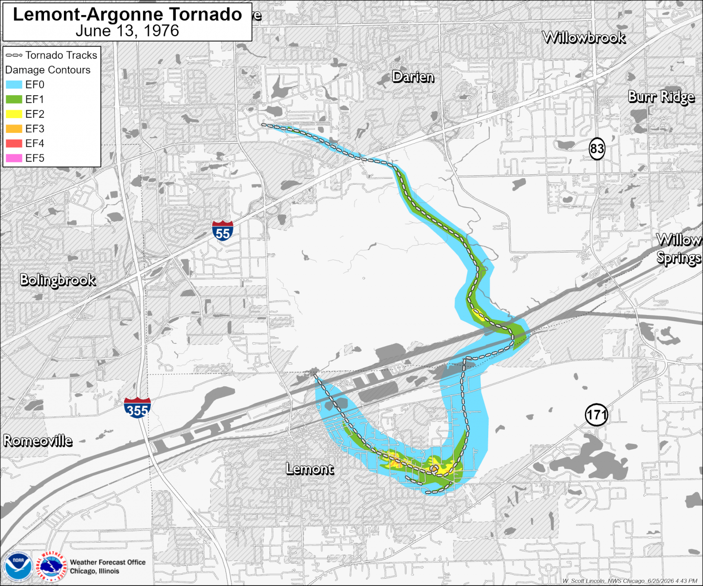
| Map showing the track of the Lemont-Argonne tornado. Note: This map includes modern geographic features (as of 2025) such as city boundaries and roads that will not necessarily match those that existed in 1976. |
||
A tornado developed just north of the Lemont business district, east of Lemont Road, around 5:18 PM. Over the next few minutes this tornado moved slowly to the south-southeast and began to widen substantially. The tornado’s direction shifted to the southeast on the then-edge of town. The tornado strengthened and moved through a few residential subdivisions in the then-less-developed areas east of Lemont. After peaking at F4 damage intensity near McCarthy Road and 5th Street, the tornado completed a full loop near McCarthy Road and Hillcrest Drive, and then began a shift to the north-northeast along Walker Road near Cog Hill Golf Course, causing damage of F1 to F2 intensity around 5:30 PM.
Around the time the tornado made the turn toward the north, two anticyclonic satellite tornadoes formed just to the south. The first anticyclonic tornado moved through an area that was then just a field. The second anticyclonic tornado formed in a then field, then moved across a farmstead toward the primary tornado.
 |
||
| Map showing the track of the Lemont-Argonne tornado as it moved through Lemont and then reached peak intensity just east of town. Note that many roads depicted on this map, including the homes along them, did not exist in June of 1976. | ||
The tornado crossed the Chicago Sanitary & Ship Canal and the Des Plaines River around 5:48 PM, continuing to follow a curvy path generally to the north-northeast, and then damaged some metal high-tension electrical transmission lines. At Argonne National Laboratory, the tornado turned toward the northwest and damage intensity decreased to F1, with some roof damage occurring to a building housing a nuclear reactor.
 |
||
| Map showing the track of the Lemont-Argonne tornado as it moved through Argonne National Laboratory and Waterfall Glen Forest Preserve. | ||
The tornado crossed I-55 at F1 intensity and turned toward the west-northwest. The tornado moved through the Brookeridge subdivision south of Downers Grove and southwest of Darien, causing roof damage to multiple houses, before dissipating around 6:20 PM just east of Lemont Road.
 |
||
| Map showing the track of the Lemont-Argonne tornado as it moved across I-55 into the Brookeridge subdivision south of Downers Grove and southwest of Darien. Note that many roads depicted on this map, including the homes along them, did not exist in June of 1976. | ||
The 1976 Lemont-Argonne tornado was on the ground for a little over 1 hour, but the slow and sometimes stationary movement, along with a somewhat erratic path, led to a total path length of only 8.3 miles. The formation and dissipation locations were only 3.3 miles apart, each just east of Lemont Road. In addition to the main tornado, two brief anticyclonic tornadoes were produced by the same supercell thunderstorm, with tracks just to the south and southwest of the primary tornado.
Long-Duration Hail
In addition to the Lemont-Argonne tornado and flash flood producing rainfall, a notable hail event occurred in southeastern DuPage and western Cook counties. According to an analysis by Dr. Ted Fujita, several areas experienced several minutes of nearly continuous hail. At Chicago Midway Airport, hail occurred for a 60-minute period beginning at 5:39 PM CDT while hail occurred for up to 90 minutes just southwest of Willow Springs. Areas that experienced hail for at least 10 minutes extended from as far west as Lisle east to the Lake Michigan shore, and as far north as Franklin Park to as far south as Dolton. It was estimated that the areal extent of hail covered 410 square miles, with stones up to 1.5 inches in diameter.
Storm Survey Reanalysis Limitations
The reanalysis of damage intensity used to produce these maps was limited by the availability of ground and aerial imagery along the tornado’s path. Special thanks to the Lemont Area Historical Society for providing access to their large collection of photos and newspaper articles covering this event, without which detailed reanalysis for areas east of Lemont would not be possible.
Although a large collection of photographs taken by Dr. Ted Fujita and National Weather Service staff during multiple aerial surveys along the entire tornado's path are known to exist, they were not made available for this analysis.
Sources of information used for this analysis include:
Anticyclonic Tornadoes, Dr. Ted Fujita
Weatherwise volume 30
Mesoanalysis of record Chicago rainstorm using radar, satellite, and rain gauge data, Dr. Ted Fujita
An Analysis of Extreme Rainfall Events in Chicago and Vicinity Since 1950, NWS CR Technical Service Publication 21, W. Scott Lincoln
Downers Grove Reporter newspaper
Lemont Metropolitan newspaper
Chicago Tribune newspaper
Lemont Area Historical Society archives
Flash Flooding
The slow, nearly stationary movement of the supercell responsible for the Lemont-Argonne Tornado cause quick accumulations of significant rainfall across a small portion of the central Chicago Metropolitan area. Up to 7 inches of rainfall occurred over a 3-hour period in Chicago just southeast of Chicago Midway Airport. Flooding surrounded multiple homes in Burbank through the south side of Chicago and flooded multiple roadways, including I-294 and I-94/I-90.
 |
 |
| Map showing rainfall produced by the supercell thunderstorm responsible for the Lemont-Argonne Tornado. Rainfall occurred over an approximately 3-hour period from 5:00 PM to 8:00 PM CDT. | Map showing known areas of flooding caused by the supercell thunderstorm responsible for the Lemont-Argonne Tornado. Rainfall with 1% chance of occurring in a given year or lower indicated by gray shading. |
For more information about this flood event, see NWS Central Region Technical Service Publication 21, An Analysis of Extreme Rainfall Events in Chicago and Vicinity Since 1950.
Meteorology and Environment
Radar
Imagery collected by the WSR-74 radar site MMO on June 13, 1976, showed a single storm develop over eastern DuPage and western Cook counties. This echo was almost stationary, moving very slowly to the southeast, around 5:00 PM CDT (2200 UTC). The Lemont-Argonne tornado formed on the southwest side of this storm in far southeastern DuPage County around 5:18 PM (2218 UTC). The tornado then followed its winding path to the southeast, east, north, and then northwest over the next hour. Due to little or no precipitation falling from the storm near the tornado, no characteristic hook echo was present. At 5:32 PM (2232 UTC), a few minutes after the Lemont-Argonne tornado reached peak intensity east of Lemont, an area of lower reflectivity was detected by the radar centered on the location of the tornado. This circle of reflectivity may have been indicative of debris lofted by the tornado instead of precipitation.
|
|
|
Animation of digitized radar imagery from the MMO WSR-74 radar site on June 13, 1976, from 5:03 p.m. to 7:40 PM CDT, zoomed in to Chicago area. Created from hand analysis of archived radar display photos archived by Ted Fujita. |
Surface Weather
Temperatures warmed into the 80s across most of Illinois during the day on June 13, 1976. In central Illinois, temperatures near 90F were observed, with dewpoints in the upper 60s to near 70F. A possible outflow boundary from overnight rainfall possibly extended from north central to central Illinois. This outflow boundary may have contributed to the development of thunderstorms in northeastern Illinois during the late afternoon hours, but observations from 1976 are limited.
 |
 |
 |
| Surface weather map valid at 7:00 AM CDT on June 13, 1976. | Surface weather map valid at 1:00 PM CDT on June 13, 1976. | Surface weather map valid at 7:00 PM CDT on June 13, 1976. |
Upper Air
An upper sounding from Peoria, Illinois, valid a few hours after the start of the tornado indicated significant instability and wind shear with height.
|
|
|
Upper air sounding from Peoria at 7:00 PM on June 13, 1976, (0000 UTC on June 14). Archived upper air data from Plymouth State Weather. |
Advancements
In the mid-1970s, precipitation occurring across a large area from far eastern Iowa to northern Indiana was tracked using the WSR-74 radar located near Marseilles, Illinois. This radar plotted 6 levels of reflectivity intensity, or VIP levels, in contrast to modern radar systems which can differentiate more than 100 levels. The WSR-74 radar did not calculate or plot velocity toward/away from the radar required for detecting rotating storms as do modern doppler radar systems.
During this time, the primary means of tracking potential tornadoes was to receive reports from spotters, law enforcement, or the public. In addition, radar reflectivity sometimes presented with a "hook echo" that was associated with rotating storms. It is known today that not all tornado-producing storms have hook echoes on radar, and not all hook echoes are associated with tornadoes.
 |
 |
 |
| Copy of original photograph of the Marseilles (MMO) WSR-74 radar display valid at 5:32 PM CDT on June 13, 1976, around the time of peak tornado intensity. Red dot annotation added by Dr. Ted Fujita indicates approximate location of the tornado. | Digitized radar data from the Marseilles (MMO) WSR-74 radar site valid at 5:32 PM CDT on June 13, 1976. | Example radar image of a rotating thunderstorm with a hook echo, as detected by the modern NEXRAD doppler radar system. Image from KIWX radar site on May 7, 2024. |
Photos
 |
 |
| Multiple homes at the then south end of 6th Street east of Lemont destroyed by the Lemont-Argonne Tornado. Dr. Ted Fujita rated the peak damage in this area F4. Photo by Dr. Ted Fujita, Weatherwise volume 30. |
Multiple homes south of McCarthy Road along 2nd Street, 3rd Street, and 4th Street east of Lemont damaged or destroyed by the Lemont-Argonne Tornado. Dr. Ted Fujita rated damage in this area from F1 to F4. From the Lemont Area Historical Society. |
 |
 |
 |
| Multiple homes south of McCarthy Road along 4th Street were damaged or destroyed by the Lemont-Argonne Tornado. From the Lemont Area Historical Society. | A farmstead along McCarthy Road east of Hillcrest Drive was significantly damaged by the Lemont-Argonne Tornado. From the Lemont Area Historical Society. | Multiple homes along Hillcrest Drive, just north of McCarthy Road, were damaged or destroyed by the Lemont-Argonne Tornado. From the Lemont Area Historical Society. |
 |
||
| A few homes along 86th Street in the Brookeridge subdivision south of Darien and Downers Grove were damaged by the Lemont-Argonne Tornado. Unknown photographer, from the Argonne National Laboratory collection. |
 |
 |
 |
| View of the Lemont-Argonne Tornado from Orland Park as the tornado was east of Lemont. Photo by John Rusnak, from a collection of videos and animations compiled by Dr. Ted Fujita for the National Weather Service, NASA, and the Nuclear Regulatory Commission. | View of the Lemont-Argonne Tornado from Orland Park as the tornado was near the Des Plaines River. Photo by John Rusnak, from a collection of videos and animations compiled by Dr. Ted Fujita for the National Weather Service, NASA, and the Nuclear Regulatory Commission. | View of the Lemont-Argonne Tornado from Orland Park as the tornado was near Argonne National Laboratory. Photo by John Rusnak, from a collection of videos and animations compiled by Dr. Ted Fujita for the National Weather Service, NASA, and the Nuclear Regulatory Commission. |
 |
 |
 |
| View of the Lemont-Argonne Tornado from near McCarthy Road and Derby Road east of Lemont. Photo shows the tornado as it was near Hillcrest Road, shortly after peak intensity. Photo by Edward Lebak, from a collection of videos and animations compiled by Dr. Ted Fujita for the National Weather Service, NASA, and the Nuclear Regulatory Commission. | View of the Lemont-Argonne Tornado from near Keepataw Drive and Crestview Drive in Lemont. Photo shows the tornado near peak intensity as it was along McCarthy Road east of Lemont. Photo by Irwin Pasiewicz, from a collection of videos and animations compiled by Dr. Ted Fujita for the National Weather Service, NASA, and the Nuclear Regulatory Commission. | View of the tornado from near 127th and 126th streets southeast of Lemont. Location has now been redeveloped and is near today’s Covington Drive and Baimbridge Court. Research continues into what is being shown by this photo series, but analysis by Dr. Fujita (Weatherwise, volume 30) determined that this photo was part of a series showing development of the first anticyclonic tornado on the southwest side of the primary tornado.. Photo by Joyce Olinger, provided by the Lemont Area Historical Society. |
 |
||
| View of the Lemont-Argonne Tornado from near IL-83 and Mockingbird Lane east of Argonne National Laboratory. Photo shows the tornado as it was moving through the Argonne campus. Unknown photographer, from the Argonne National Laboratory collection. |
Additional Information
On the same date of the Lemont-Argonne Tornado, a separate storm produced an F5 tornado in central Iowa that impacted the village of Jordan.
Links:
 |
Media use of NWS Web News Stories is encouraged! Please acknowledge the NWS as the source of any news information accessed from this site. Additional event recaps can be found on the NWS Chicago Past Events Page |
|





 Follow us on X
 Follow us on Facebook
 Follow us on YouTube
 LOT RSS Feed