
Severe thunderstorms capable of damaging winds will be possible from the Ozark Plateau east into portions of the Southeast today. Rounds of heavy thunderstorms ahead of a slow moving front will continue locally heavy rainfall and scattered flash flooding potential from the Ozarks to the Ohio and Tennessee Valleys today. Read More >
Chicago, IL
Weather Forecast Office
A significant outbreak of severe thunderstorms and tornadoes occurred on the afternoon and night of Oct 18, 2007, with severe weather reported from the Guf Coast northward to the Upper Peninsula of Michigan. In the local area, the majority of the severe weather was confined to areas along and southeast of I-55...with reports of up to golf ball size hail in Joliet and one brief tornado touchdown in Benton County Indiana.
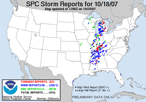
There were several tornadoes that occurred in Michigan, Indiana, and Kentucky. These tornadoes were responsible for several fatalities and many injuries as they destroyed many homes and businesses across the region. More detailed information on the tornadoes, including pictures of the damage and track maps of the tornadoes can be found on the various National Weather Service webpages.
Hazards
Enhanced Hazardous Weather Outlook
Hazardous Weather Outlook
National Briefing
Storm Spotter Training and Seminars
Outlooks
Watch/Warning/Advisory Criteria
Snow Squall Warnings
Local Forecasts
Marine
Aviation
Fire
Text Products
Great Lakes Marine Portal
Lake Michigan Beach Forecast
El Nino
Snow and Ice Probabilities
US Dept of Commerce
National Oceanic and Atmospheric Administration
National Weather Service
Chicago, IL
250 George J Michas Dr.
Romeoville, IL 60446
815-834-1435 8am-8pm
Comments? Questions? Please Contact Us.

