
Wildfire smoke will push into the Midwest, worsening air quality. A frontal system brings severe storms from the Northern Plains to the Mid‑Atlantic the next few days. Heavy Gulf Coast rain is possible as Tropical Depression Two has formed, while monsoonal storms persist in the Southwest with heavy rainfall. Hazardous heat expands from the Plains into the Lower Mississippi Valley. Read More >
Chicago, IL
Weather Forecast Office
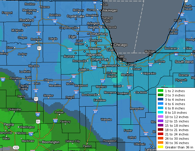
An area of low pressure lifted out of the southern plains and into the Ohio Valley on January 20th (See Below for Satellite Imagery) as it interacted with an upper level disturbance that moved in from the northern plains. These came together with an abundance of moisture and the right ingredients to produce healthy and efficient snowfall. Northern Illinois and northwestern Indiana experienced anywhere from 4 to over 9 inches of snowfall by the time the storm exited to the East.
| 06z Fri | 09z Fri | 12z Fri | 15z Fri | 18z Fri | 21z Fri | 00z Sat |
Below are snapshots of the regional and local snowfall that impacted the entire midwest.

Local Radar Imagery (click for a large loop)
.gif)
Here is a preliminary look at the snowfall totals from January 20th, 2012:
| Local Storm Report Summary | Ranked Snowfall Reports |
*The Ranked Snowfall Reports are composed of NWS COOP and CoCoRaHS reports only - NO Public LSR's
Hazards
Enhanced Hazardous Weather Outlook
Hazardous Weather Outlook
National Briefing
Storm Spotter Training and Seminars
Outlooks
Watch/Warning/Advisory Criteria
Snow Squall Warnings
Local Forecasts
Marine
Aviation
Fire
Text Products
Great Lakes Marine Portal
Lake Michigan Beach Forecast
El Nino
Snow and Ice Probabilities
US Dept of Commerce
National Oceanic and Atmospheric Administration
National Weather Service
Chicago, IL
250 George J Michas Dr.
Romeoville, IL 60446
815-834-1435 8am-8pm
Comments? Questions? Please Contact Us.

