Tropical Depression Two is expected to gradually strengthen and could bring tropical storm conditions to the Florida Panhandle beginning late Monday. Areas of flash flooding will be possible through Thursday along the eastern and central Gulf Coast. Severe thunderstorms will develop and move along a cold front crossing the Upper Midwest Monday, and through the Ohio Valley/Mid-Atlantic on Tuesday. Read More >
Freezing drizzle developed over north central Illinois on the afternoon of January 26th and spread into the Chicago metro and the I-55 and I-57 corridors in east central Illinois by or shortly after sunset. While only trace to light amounts, the freezing drizzle quickly created slick conditions on untreated roads, parking lots, and sidewalks.
|
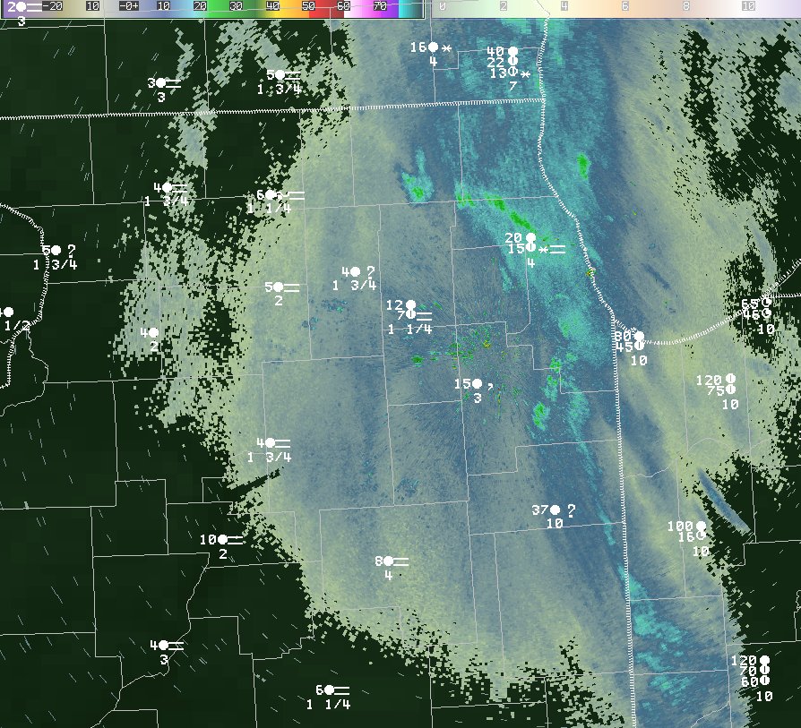
Jan 26, 2015: 5 pm NWS Chicago 0.5° Reflectivity and Observations |
|
|
|
The light echoes (<10 dBZ) indicate the radar energy is sampling very small targets, in this case drizzle. The observations of "?" are very likely freezing drizzle, as the present weather sensors are programmed to report "unknown precipitation" when a definite type cannot be defined, which is most commonly freezing drizzle, freezing rain, sleet, or a mix including one of these. |
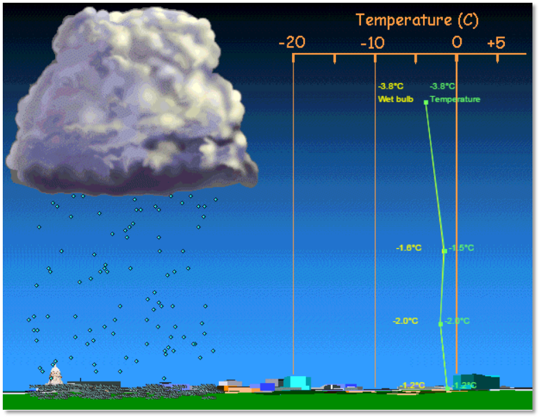
Many meteorologists will tell you freezing drizzle is one of the more challenging weather elements to predict. For one, it is usually quite light in intensity and thus typical observing techniques (sensors and radar) may not identify it. It is also difficult for computer models to predict due to it happening in only the most shallow levels of the atmosphere and its light intensity. Finally, freezing drizzle needs a certain thermal profile to develop, one that has supercooled liquid with lift in the lowest part of the atmosphere. Often with weather systems in the winter, lift is enough to deeply saturate for snow development, making freezing drizzle less common.
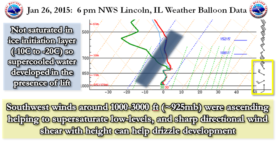
Even when the atmosphere is entirely below freezing (32°F), it does not guarantee snowflake development within the clouds. In fact, the atmosphere needs to be saturated below 18°F (-8°C) to have ice crystal initiation to occur, and sometimes even a few degrees cooler than that. Here is a look at weather balloon data from our colleagues at NWS Lincoln, IL on the evening of January 26th depicting the lack of saturation at that cool of a level. The two lines (red as temperature and green as dew point) need to be together to indicate saturation. They had been saturated earlier in the day when snowfall occurred, but dried behind the passing of an upper level disturbance.
|
|
|
Conceptual Look at Freezing Drizzle |
|
|
|
To experiment with precipitation type conceptual models, visit this University of Wisconsin & CIMMS page. |
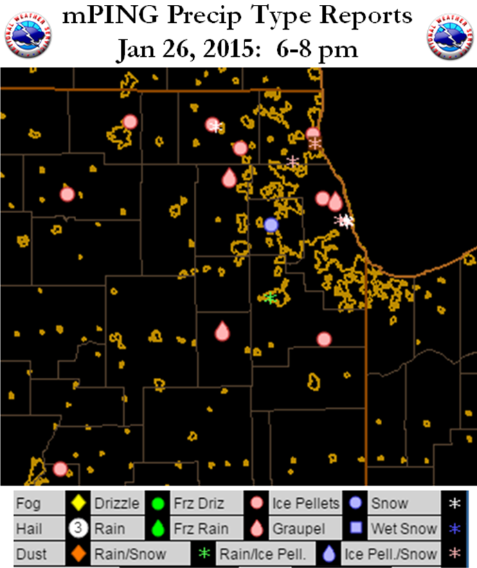
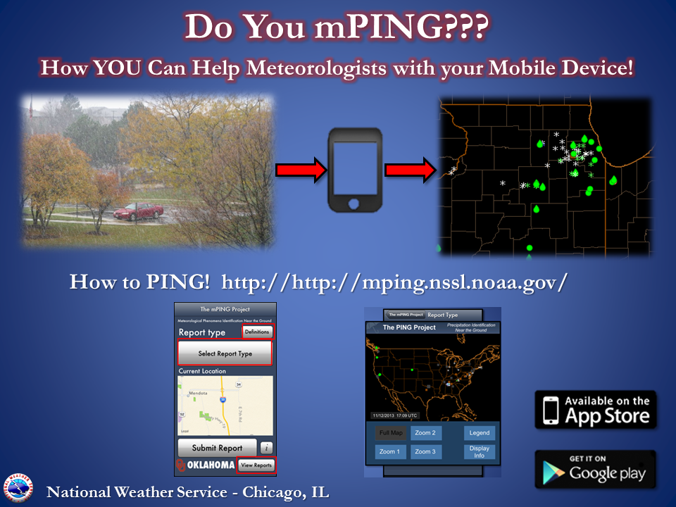
Precipitation type reports are especially helpful to forecasters during possible icing events, as most sensors struggle to report icing. Below is a look at reports through an NWS NSSL mobile device application. Try it out if you have a chance!
|
|
|
|
Storm Reports
PRELIMINARY LOCAL STORM REPORT...SUMMARY
NATIONAL WEATHER SERVICE CHICAGO/ROMEOVILLE IL
530 AM CST TUE JAN 27 2015

..TIME...   ...EVENT...      ...CITY LOCATION...     ...LAT.LON...
..DATE...   ....MAG....      ..COUNTY LOCATION..ST.. ...SOURCE....
            ..REMARKS..

0525 AM     SNOW             WOODSTOCK               42.31N 88.44W
01/27/2015  M0.5 INCH        MCHENRY            IL   TRAINED SPOTTER

            TOTAL SNOWFALL.

1200 AM     SNOW             ROCKFORD AIRPORT        42.20N 89.10W
01/27/2015  M0.4 INCH        WINNEBAGO          IL   OFFICIAL NWS OBS

1200 AM     SNOW             ROMEOVILLE              41.65N 88.09W
01/27/2015  M0.8 INCH        WILL               IL   OFFICIAL NWS OBS

            TOTAL SINCE NOON ON MONDAY.

1200 AM     SNOW             3 SW MIDWAY AIRPORT     41.75N 87.79W
01/27/2015  M0.7 INCH        COOK               IL   CO-OP OBSERVER

            0.05 OF AN INCH LIQUID EQUIVALENT. ONE INCH OF SNOW
            DEPTH.

1200 AM     SNOW             OHARE AIRPORT           41.98N 87.90W
01/27/2015  M1.0 INCH        COOK               IL   OFFICIAL NWS OBS

            TOTAL SNOWFALL SINCE NOON ON MONDAY.

1130 PM     SNOW             1 SE CHICAGO            41.87N 87.62W
01/26/2015  M0.7 INCH        COOK               IL   NWS EMPLOYEE

            SINCE 9 PM MONDAY EVENING.

0625 PM     FREEZING RAIN    3 N CARBON HILL         41.34N 88.30W
01/26/2015  E0.00 INCH       GRUNDY             IL   COCORAHS

            THIN COATING OF ICE ON MOST SURFACES FROM FREEZING
            DRIZZLE. MANY ACCIDENTS REPORTED IN THE AREA

0615 PM     FREEZING RAIN    HARWOOD HEIGHTS         41.97N 87.81W
01/26/2015  U0.00 INCH       COOK               IL   TRAINED SPOTTER

            FREEZING DRIZZLE WITH ICY SIDE STREETS

0600 PM     SNOW             CREST HILL              41.57N 88.11W
01/26/2015  M0.5 INCH        WILL               IL   TRAINED SPOTTER

            LIGHT FREEZING DRIZZLE NOW

0515 PM     FREEZING RAIN    DOWNERS GROVE           41.80N 88.02W
01/26/2015  E0.00 INCH       DUPAGE             IL   TRAINED SPOTTER

            LIGHT FREEZING DRIZZLE MIXED IN WITH SNOW

0500 PM     FREEZING RAIN    DE KALB                 41.93N 88.75W
01/26/2015  E0.00 INCH       DEKALB             IL   TRAINED SPOTTER

            ICING ON ROADS, MULTIPLE CARS IN DITCH

0315 PM     SNOW             CAPRON                  42.40N 88.74W
01/26/2015  M0.6 INCH        BOONE              IL   TRAINED SPOTTER

0245 PM     FREEZING RAIN    LELAND                  41.61N 88.80W
01/26/2015  U0.00 INCH       LA SALLE           IL   TRAINED SPOTTER

            FREEZING DRIZZLE MIXED WITH FLURRIES


&&

$$

MTF