
Widespread life-threatening flash and urban flooding continues in south-central Texas, with considerable flooding impacts possible across central Texas. Wildfire smoke is impacting air quality across much of the Great Lakes region into southern New England and the Mid-Atlantic. Monsoonal thunderstorms may produce isolated to scattered flash flooding across the Southwest into the Great Basin. Read More >
Overview
|
Scattered thunderstorms quickly became numerous along the I-88 corridor on the early afternoon of Friday, July 29th. These were extremely slow moving, leading to large totals in a short amount of time. With antecedent wet conditions, this rainfall brought flash flooding to DeKalb, Kane, DuPage, and Cook Counties. Some of the flooding persisted into the day after. In addition, the DuPage River at Bolingbrook reached a top 10 crest in its ~20 year period of record. |
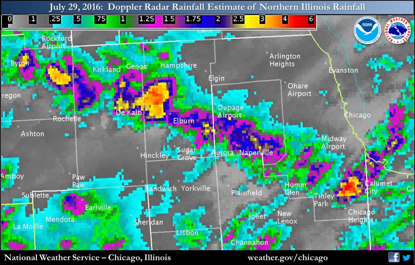 Rainfall Estimated from Bias-Corrected Radar |
Flooding:
Header
 |
 |
 |
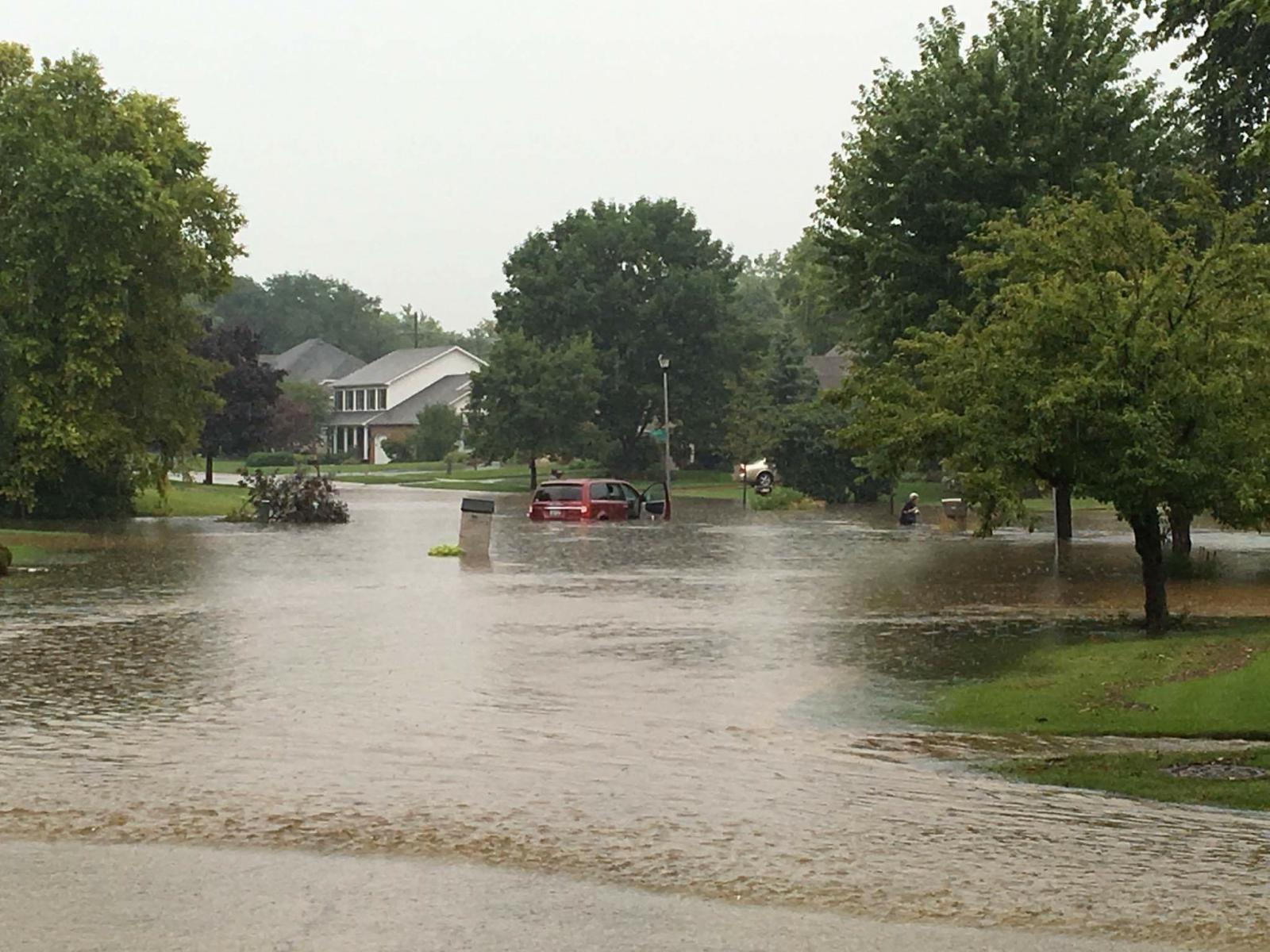 |
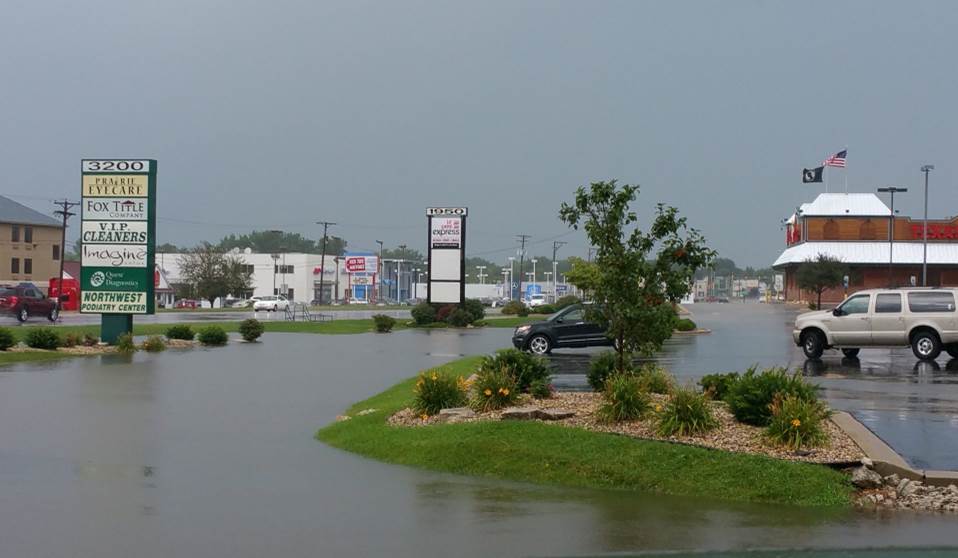
| Sycamore, IL (via social media share) |
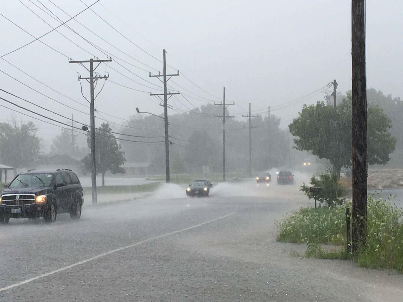
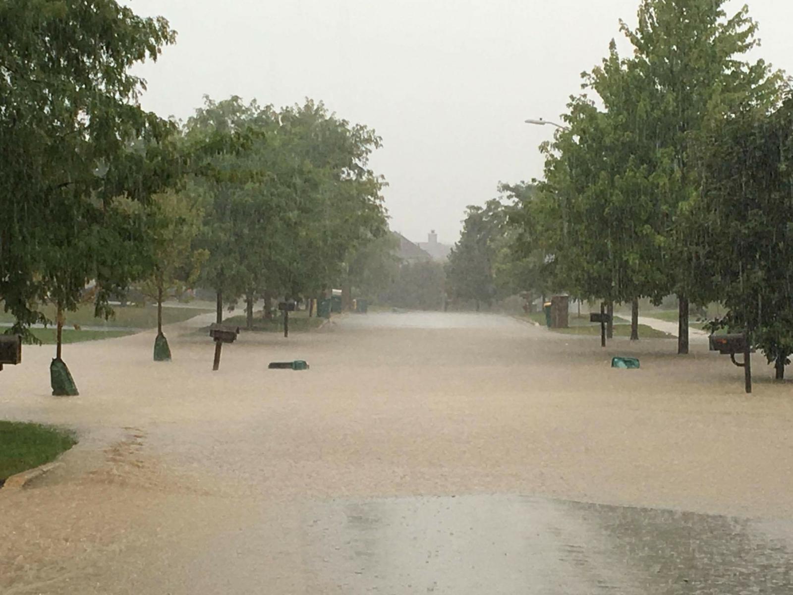
Batavia, IL Matt Piechota |
Batavia, IL Matt Piechota |
Batavia, IL Matt Piechota |
Rain Reports
|
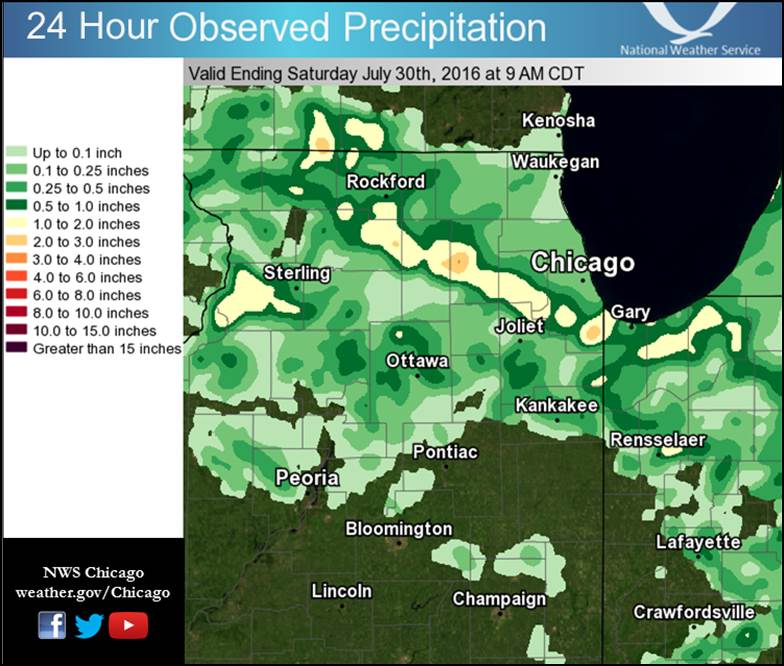 |
| Rainfall Estimated from Bias-Corrected Radar | Rainfall Interpolated from Observers |
Public Information Statement
National Weather Service Chicago IL
1019 AM CDT Sat Jul 30 2016

...Morning Rainfall Roundup...

   The following are rain amounts for the previous 24-hours
   as measured in the morning by NWS Cooperative Observers
   and CoCoRaHS observers.
   Observations are usually taken between 6 AND 8 AM.

   24-hour rainfall amounts
       for Saturday(07/30/16)...


Illinois                                       Rain
  Location (County):                           fall (inches)

  North Aurora 2NE (Kane)......................3.40
  Darien (Du Page).............................3.34
  Bolingbrook 3NE (Du Page)....................3.07
  Homewood (Cook)..............................3.00
  Aurora 4NE (Du Page).........................2.70
  Naperville 2ESE (Du Page)....................2.65
  Aurora (Kane)................................2.59
  Lisle 1SE (Du Page)..........................2.49
  Batavia 1WSW (Kane)..........................2.41
  Batavia (Kane)...............................2.09
  Naperville 2SE (Du Page).....................2.03
  Lisle (Du Page)..............................1.89
  Geneva 4WSW (Kane)...........................1.86
  Naperville 1NW (Du Page).....................1.79
  Westmont (Du Page)...........................1.64
  Alsip (Cook).................................1.58
  Elburn (Kane)................................1.50
  Geneva 1SSW (Kane)...........................1.46
  Beecher 3SSE (Will)..........................1.45
  Burr Ridge 2SW (Du Page).....................1.44
  Batavia 2WNW (Kane)..........................1.39
  Batavia 1WNW (Kane)..........................1.36
  La Salle (La Salle)..........................1.35
  Elburn (Kane)................................1.33
  Downers Grove 1S (Du Page)...................1.24
  Lansing (Cook)...............................1.23
  Genoa (De Kalb)..............................1.18
  Lily Lake 2E (Kane)..........................1.18
  Joliet Lock/dam (Will).......................1.10
  Midway Coop (Cook)...........................1.08
  Worth (Cook).................................1.07
  Oak Lawn 2WNW (Cook).........................1.07
  Glen Ellyn 2SSE (Du Page)....................0.99
  Bourbonnais (Kankakee).......................0.97
  Downers Grove 0.4NNE (Du Page)...............0.97
  Beecher 3ENE (Will)..........................0.95
  Rockford (Winnebago).........................0.94
  Willow Springs (Cook)........................0.92
  Oak Lawn (Cook)..............................0.88
  Palos Park 1SW (Cook)........................0.83
  Peru 1SW (La Salle)..........................0.83
  Homer Glen 1ENE (Will).......................0.76
  Hampshire (Kane).............................0.75
  Elgin 8WSW (Kane)............................0.73
  Channahon 1NNE (Will)........................0.72
  Manhattan 1ESE (Will)........................0.71
  Naperville 4SSW (Will).......................0.71
  Winfield (Du Page)...........................0.66
  Ottawa (La Salle)............................0.65
  Capron (Boone)...............................0.64
  Byron 3N (Ogle)..............................0.60
  Manhattan 2SE (Will).........................0.59
  De Kalb (De Kalb)............................0.57
  Morris (Grundy)..............................0.56
  West Chicago (Du Page).......................0.53
  St. Charles (Kane)...........................0.53
  Lombard 1NNW (Du Page).......................0.45
  Romeoville (Will)............................0.45
  Marseilles (La Salle)........................0.43
  Carol Stream (Du Page).......................0.42
  St. Charles 6NW (Kane).......................0.40
  Rockford 3NE (Winnebago).....................0.39
  Aurora 4SE (Du Page).........................0.38
  Channahon 2SSE (Will)........................0.37
  Aurora (Kane)................................0.36
  Aurora 4SE (Du Page).........................0.35
  Midway (Cook)................................0.33


Indiana                                        Rain
  Location (County):                           fall (inches)

  Valparaiso 2WNW (Porter).....................3.11
  Valparaiso 1NNW (Porter).....................3.01
  Valparaiso 2NW (Porter)......................2.74
  Rensselaer 8ENE (Jasper).....................1.82
  Gary 4SSW (Lake).............................1.66
  Valparaiso 3WSW (Porter).....................1.58
  Valparaiso 1NE (Porter)......................1.57
  Hobart 1SSW (Lake)...........................1.27
  Gary 5ENE (Lake).............................1.20
  Valparaiso 1SE (Porter)......................1.18
  Portage 3E (Porter)..........................1.13
  Chesterton 4E (Porter).......................1.12
  Valparaiso 5WSW (Porter).....................1.02
  Crown Point 1N (Lake)........................1.00
  Valparaiso 6WSW (Porter).....................0.98
  (w9opr)Wheatfield 1ENE (Jasper)..............0.90
  Valparaiso 4SW (Porter)......................0.85
  Valparaiso 7WSW (Porter).....................0.84
  Rensselaer 10NNE (Jasper)....................0.76
  Hobart 1NNW (Lake)...........................0.63
  St. John (Lake)..............................0.61
  Lake Village (Newton)........................0.60
  Crown Point 2WSW (Lake)......................0.52
  Valparaiso 6NW (Porter)......................0.52
  De Motte 6S (Jasper).........................0.48
  Portage 1ESE (Porter)........................0.48
  Winfield 1NE (Lake)..........................0.45
  (w9mal)Merrillville 2NNW (Lake)..............0.43
  Schererville 1E (Lake).......................0.42
  Rensselaer (Jasper)..........................0.34
  Rensselaer 2SSW (Jasper).....................0.30
Radar:
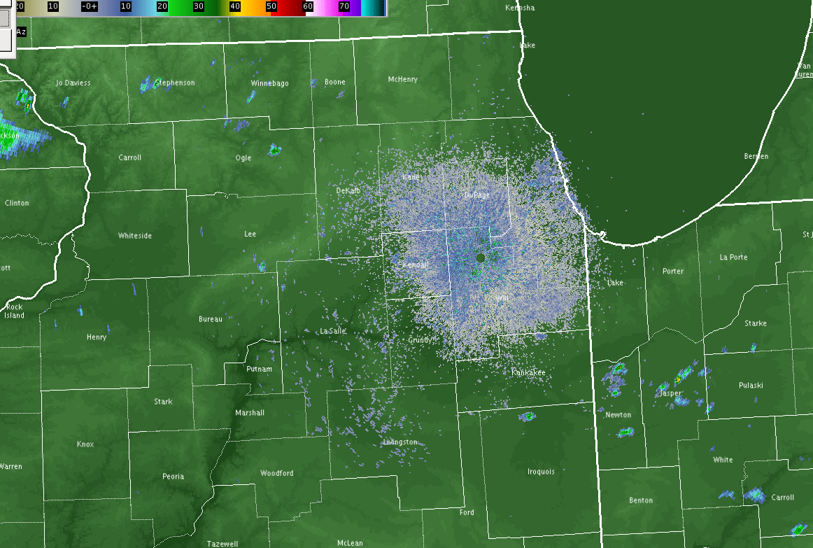 |
| July 29 Radar Loop at 15 minute intervals: 11:15 a.m. - 7:00 p.m. |
Storm Reports
PRELIMINARY LOCAL STORM REPORT...SUMMARY
NATIONAL WEATHER SERVICE CHICAGO/ROMEOVILLE IL
750 AM CDT SAT JUL 30 2016

..TIME...   ...EVENT...      ...CITY LOCATION...     ...LAT.LON...
..DATE...   ....MAG....      ..COUNTY LOCATION..ST.. ...SOURCE....
            ..REMARKS..

0156 PM     HEAVY RAIN       LANSING                 41.57N 87.55W
07/29/2016  M0.96 INCH       COOK               IL   CO-OP OBSERVER

            RAINFALL IN 30 MINUTES

0230 PM     FLASH FLOOD      BOLINGBROOK             41.70N 88.08W
07/29/2016                   WILL               IL   TRAINED SPOTTER

            SECTION OF JANES AVE IMPASSABLE BETWEEN 75TH AND
            BOUGHTON.

0230 PM     FLASH FLOOD      BATAVIA                 41.85N 88.30W
07/29/2016                   KANE               IL   TRAINED SPOTTER

            WATER UP TO TOP OF TIRES ON RT 25 EAST OF WILSON ROAD

0233 PM     FLASH FLOOD      BOLINGBROOK             41.70N 88.08W
07/29/2016                   WILL               IL   TRAINED SPOTTER

            WATER UP TO BASE OF CAR DOORS IN PARKING LOT AT BOUGHTON
            AND JANES

0255 PM     HEAVY RAIN       3 NE BOLINGBROOK        41.73N 88.04W
07/29/2016  M3.01 INCH       DUPAGE             IL   COCORAHS

            RAINFALL IN LAST 45 MINUTES.

0300 PM     FLOOD            SYCAMORE                41.98N 88.70W
07/29/2016                   DEKALB             IL   PUBLIC

            DITCHES AND PARKING LOTS FULL OF WATER ON CORNER OF RT 23
            AND BETHANY. REPORT RELAYED VIA SOCIAL MEDIA.

0300 PM     FLASH FLOOD      DARIEN                  41.75N 87.98W
07/29/2016                   DUPAGE             IL   PUBLIC

            MULTIPLE ROADS FLOODED INCLUDING CASS AND CLARENDON HILLS
            ROADS.

0304 PM     HEAVY RAIN       2 WNW VALPARAISO        41.49N 87.09W
07/29/2016  M2.96 INCH       PORTER             IN   COCORAHS

            2.96 INCHES OF RAIN IN 1.5 HOURS. ALSO WIND GUST OF 40
            MPH AT 211 PM.

0320 PM     HEAVY RAIN       1 SE VALPARAISO         41.47N 87.04W
07/29/2016  M1.11 INCH       PORTER             IN   COCORAHS

            PAST 30 MINUTES

0345 PM     HEAVY RAIN       3 SW MIDWAY AIRPORT     41.75N 87.79W
07/29/2016  M1.07 INCH       COOK               IL   CO-OP OBSERVER

            STORM TOTAL THROUGH 345 PM.

0400 PM     FLOOD            VALPARAISO              41.48N 87.05W
07/29/2016                   PORTER             IN   LAW ENFORCEMENT

            MINOR STREET FLOODING.

0440 PM     HEAVY RAIN       HOMEWOOD                41.56N 87.66W
07/29/2016  M2.59 INCH       COOK               IL   COCORAHS

            STORM TOTAL THIS AFTERNOON SO FAR.

0440 PM     FLOOD            HOMEWOOD                41.56N 87.66W
07/29/2016                   COOK               IL   COCORAHS

            SEVERAL INCHES OF WATER ON 183RD...HALSTED AND AT RIDGE
            AND RIEGEL ROADS.

0444 PM     HEAVY RAIN       4 WSW LISLE             41.77N 88.17W
07/29/2016  M1.76 INCH       DUPAGE             IL   COCORAHS

            PAST 3 AND A HALF HOURS.

0444 PM     TSTM WND DMG     3 NE NEW MILLFORD       42.21N 89.02W
07/29/2016                   WINNEBAGO          IL   TRAINED SPOTTER

            ONE LARGE TREE BLOWN DOWN ON LINDEN ROAD.

0444 PM     HEAVY RAIN       1 NW NAPERVILLE         41.77N 88.17W
07/29/2016  M1.76 INCH       DUPAGE             IL   COCORAHS

            RAIN FELL IN 3.5 HOURS

0445 PM     FLOOD            WOODRIDGE               41.74N 88.04W
07/29/2016                   DUPAGE             IL   PUBLIC

            SOUTHBOUND ROUTE 53 CLOSED NEAR 83RD STREET DUE TO
            FLOODING. VIA SOCIAL MEDIA.

0525 PM     HEAVY RAIN       1 NE NORTH AURORA       41.81N 88.32W
07/29/2016  M3.38 INCH       KANE               IL   COCORAHS

            RAINFALL OVER ABOUT 3 HOURS BETWEEN 225 PM AND 525 PM
            CDT.

0530 PM     FLASH FLOOD      SOUTH HOLLAND           41.60N 87.60W
07/29/2016                   COOK               IL   PUBLIC

            168TH EAST OF STATE STREET WAS CLOSED DUE TO QUICK RISING
            WATER.

0555 PM     HEAVY RAIN       4 SSE ROCKFORD          42.22N 89.03W
07/29/2016  M2.62 INCH       WINNEBAGO          IL   COCORAHS

            RAIN FELL IN PAST 2 HOURS.

0648 PM     FLOOD            WOODRIDGE               41.74N 88.04W
07/29/2016                   DUPAGE             IL   EMERGENCY MNGR

            MULTIPLE ROADS BLOCKED BY FLOOD WATERS ACROSS SOUTHERN
            DUPAGE COUNTY. WORST IS GENERALLY ALONG AND SOUTH OF 75TH
            STREET.

1000 PM     FLOOD            DARIEN                  41.75N 87.98W
07/29/2016                   DUPAGE             IL   EMERGENCY MNGR

            DAMAGE TO AN ELECTRICAL SUBSTATION BECAUSE OF CONTINUED
            RISING WATERS.


&&

$$

MTF
 |
Media use of NWS Web News Stories is encouraged! Please acknowledge the NWS as the source of any news information accessed from this site. Additional recaps can be found on the NWS Chicago Past Events Page |
|

