
Scattered strong to severe thunderstorms may pose a risk for damaging wind gusts over the Carolinas, southeast Virginia, and the Tennessee Valley Sunday afternoon then the northern Plains from late afternoon into Sunday night. Monsoonal thunderstorms may cause locally considerable flash, urban, and small stream flooding in the Southwest U.S. the next few days. Read More >
Overview
|
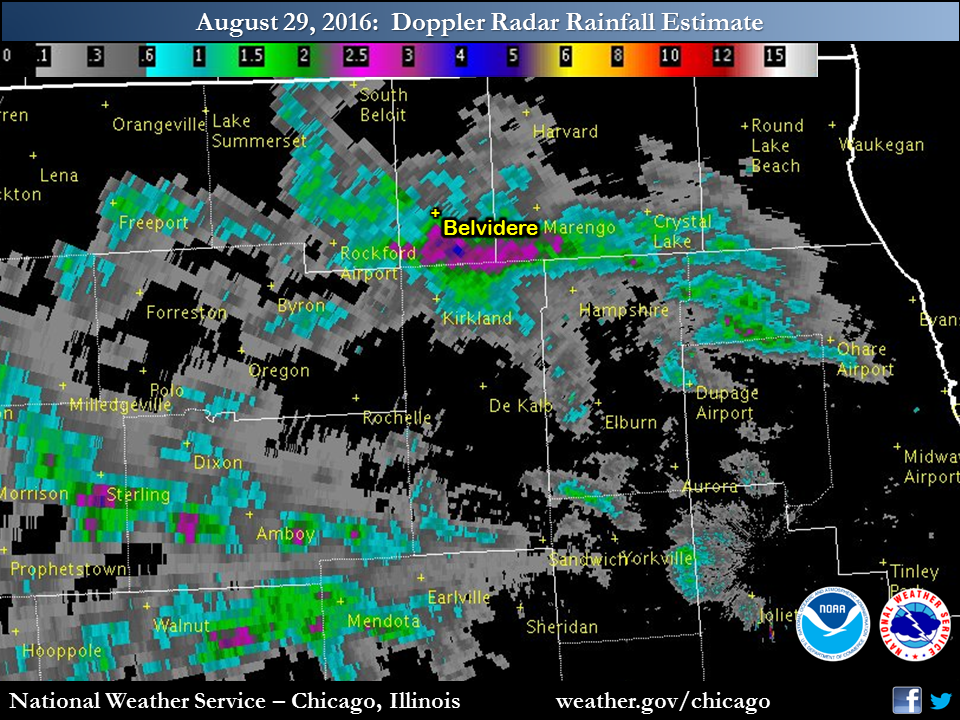
Scattered thunderstorms once again developed across northern Illinois on Monday, August 29th, bringing isolated very heavy rainfall amounts due to a moist atmosphere and slow storm motion. The locations hardest hit include along the I-90 corridor from Cherry Valley into the northwest Chicago metro, as well as some locations in Lee County near Amboy, and LaSalle County in and near Mendota and Triumph. |
 |
Storm Reports
PRELIMINARY LOCAL STORM REPORT...SUMMARY
NATIONAL WEATHER SERVICE CHICAGO/ROMEOVILLE IL
545 PM CDT TUE AUG 30 2016

..TIME...   ...EVENT...      ...CITY LOCATION...     ...LAT.LON...
..DATE...   ....MAG....      ..COUNTY LOCATION..ST.. ...SOURCE....
            ..REMARKS..

0315 PM     FLOOD            STREAMWOOD              42.02N 88.17W
08/29/2016                   COOK               IL   TRAINED SPOTTER

            SEVERAL STREETS WITH A FEW INCHES OF WATER COVERING THE
            ROAD...MOST SIGNIFICANT ALONG PARK BOULEVARD. UP TO 6
            INCHES ON ONE INTERSECTION.

0330 PM     FLASH FLOOD      10 S DIXON              41.70N 89.48W
08/29/2016                   LEE                IL   TRAINED SPOTTER

            TRAINED SPOTTER REPORTED A FOOT OF WATER MOVING ACROSS
            PUMP FACTORY ROAD BETWEEN AMBOY ROAD AND MCCOY ROAD 10
            MILES SOUTH OF DIXON.

0330 PM     HEAVY RAIN       2 WSW ELK GROVE VILLAGE 41.99N 88.03W
08/29/2016  M2.05 INCH       COOK               IL   COCORAHS

            2.05 INCHES OF RAIN OVER THE PAST TWO HOURS. MINOR CURB
            SIDE FLOODING WAS ALSO OBSERVED.

0345 PM     FLOOD            HOFFMAN ESTATES         42.06N 88.14W
08/29/2016                   COOK               IL   TRAINED SPOTTER

            ANKLE DEEP FLOOD WATERS ON THE ROAD OUTSIDE CONANT HIGH
            SCHOOL.

0350 PM     FLASH FLOOD      ROSELLE                 41.98N 88.08W
08/29/2016                   DUPAGE             IL   TRAINED SPOTTER

            IRVING PARK ROAD CLOSED DUE TO FLOODING.

0440 PM     FLOOD            6 NNE CAROL STREAM      42.00N 88.10W
08/29/2016                   COOK               IL   TRAINED SPOTTER

            PART OF THE ROUTE 390 FRONTAGE ROAD NEAR IRVING PARK ROAD
            AND WRIGHT BOULEVARD WITH UP TO 1 FT OF WATER COVERING
            IT.

0507 PM     FLOOD            MENDOTA                 41.55N 89.12W
08/29/2016                   LA SALLE           IL   PUBLIC

            CREEK OUT OF BANKS

0515 PM     HEAVY RAIN       2 SSE PLAINFIELD        41.59N 88.19W
08/29/2016  M1.01 INCH       WILL               IL   COCORAHS

            1.01 INCHES IN 25 MINUTES. MINOR FLOODING ALSO OBSERVED.

0540 PM     FLASH FLOOD      1 S BELVIDERE           42.24N 88.85W
08/29/2016                   BOONE              IL   PUBLIC

            CAR STALLED IN DEEP WATER AND OTHER FLOODED ROADS AROUND
            TOWN

0525 AM     HEAVY RAIN       2 WSW ELK GROVE VILLAGE 41.99N 88.03W
08/30/2016  M2.11 INCH       COOK               IL   COCORAHS

            24 HOUR TOTAL

0530 AM     HEAVY RAIN       AMBOY                   41.72N 89.33W
08/30/2016  M1.46 INCH       LEE                IL   COCORAHS

            24 HOUR TOTAL

0545 AM     HEAVY RAIN       1 N ALGONQUIN           42.18N 88.30W
08/30/2016  M1.58 INCH       MCHENRY            IL   COCORAHS

            24 HOUR TOTAL

0600 AM     HEAVY RAIN       3 S EARLVILLE           41.55N 88.92W
08/30/2016  M1.45 INCH       LA SALLE           IL   CO-OP OBSERVER

            24 HOUR TOTAL

0700 AM     HEAVY RAIN       5 SW PLAINFIELD         41.56N 88.27W
08/30/2016  M1.98 INCH       KENDALL            IL   COCORAHS

            24 HOUR TOTAL

0700 AM     HEAVY RAIN       2 E SCHAUMBURG          42.03N 88.04W
08/30/2016  M2.08 INCH       COOK               IL   COCORAHS

            24 HOUR TOTAL

0700 AM     HEAVY RAIN       PAW PAW                 41.69N 88.98W
08/30/2016  M2.58 INCH       LEE                IL   CO-OP OBSERVER

0700 AM     HEAVY RAIN       CARY                    42.21N 88.25W
08/30/2016  M2.08 INCH       MCHENRY            IL   COCORAHS

            24 HOUR TOTAL

0700 AM     HEAVY RAIN       PLAINFIELD              41.62N 88.20W
08/30/2016  M1.80 INCH       WILL               IL   CO-OP OBSERVER

            24 HOUR TOTAL

0725 AM     FLOOD            4 NE TROY GROVE         41.50N 89.02W
08/30/2016                   LA SALLE           IL   BROADCAST MEDIA

            IN TRIUMPH IL THERE IS STANDING WATER ACROSS
            APPROXIMATELY ONE THIRD OF THE TOWNS ROADS.
Rain Reports
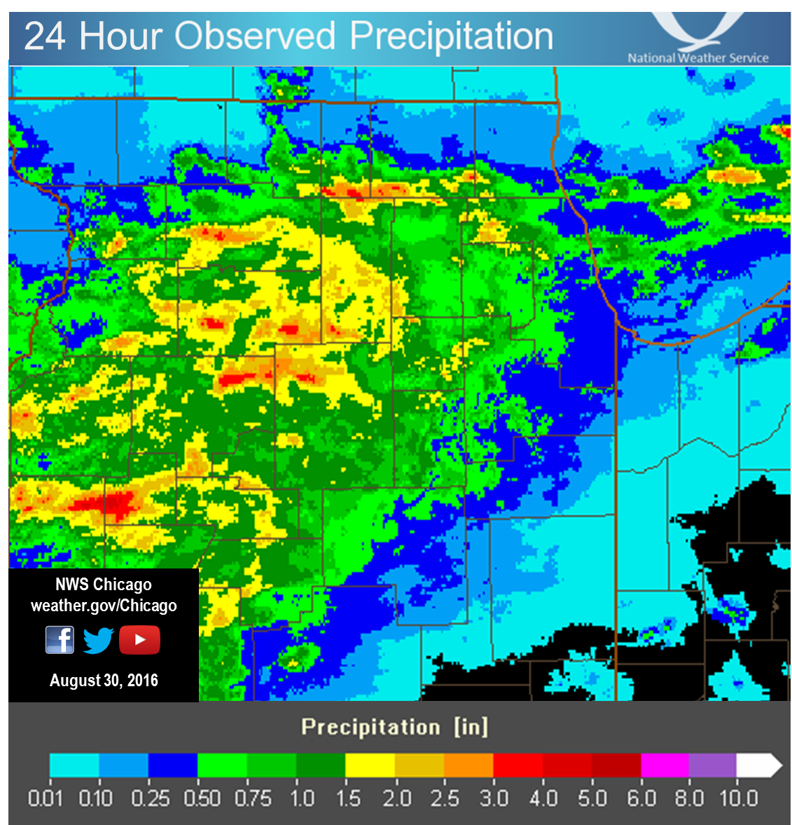 |
| 24 Hour Precipitation Ending at 7 AM August 30 |
Public Information Statement
National Weather Service Chicago IL
1028 AM CDT Tue Aug 30 2016

...Morning Rainfall Roundup...

   The following are rain amounts for the previous 24-hours
   as measured in the morning by NWS Cooperative Observers
   and CoCoRaHS observers.
   Observations are usually taken between 6 AND 8 AM.

   24-hour rainfall amounts
       for Tuesday(08/30/16)...


Illinois                                       Rain
  Location (County):                           fall (inches)

  Mendota 1N (La Salle)........................2.68
  Paw Paw (Lee)................................2.58
  Mendota (La Salle)...........................2.18
  Elk Grove Village 2WSW (Cook)................2.11
  Schaumburg 2E (Cook).........................2.08
  Cary (McHenry)...............................2.08
  Roselle 1ESE (Du Page).......................2.00
  Plainfield 5SW (Kendall).....................1.98
  Plainfield (Will)............................1.80
  Lincolnwood 3E (Cook)........................1.76
  Algonquin 1N (McHenry).......................1.58
  Amboy (Lee)..................................1.46
  Earlville 3S (La Salle)......................1.45
  De Kalb (De Kalb)............................1.43
  Rockford 2ENE (Winnebago)....................1.43
  Genoa (De Kalb)..............................1.42
  Amboy (Lee)..................................1.40
  Sublette (Lee)...............................1.40
  Plainfield 2SSE (Will).......................1.39
  Dixon 3NNW (Lee).............................1.38
  Rockford 1NW (Winnebago).....................1.23
  Streator 1WSW (La Salle).....................1.21
  Plano (Kendall)..............................1.20
  North Utica 6N (La Salle)....................1.17
  Plainfield 1SW (Will)........................1.16
  Naperville 2ESE (Du Page)....................1.15
  Shabbona (De Kalb)...........................1.14
  Roselle 1W (Du Page).........................1.13
  Belvidere (Boone)............................1.12
  Yorkville 2SE (Kendall)......................1.06
  Rockford 6S (Winnebago)......................1.03
  Steward (Lee)................................1.01
  Ashton (Lee).................................0.97
  Palatine 1E (Cook)...........................0.92
  Streamwood 1W (Cook).........................0.91
  Seneca 2SSW (La Salle).......................0.90
  Elmhurst 1ESE (Du Page)......................0.89
  Rochelle (Ogle)..............................0.88
  De Kalb (De Kalb)............................0.87
  La Salle (La Salle)..........................0.85
  Ottawa (La Salle)............................0.85
  Morris (Grundy)..............................0.84
  Dixon 2SW (Lee)..............................0.81
  Rockford (Winnebago).........................0.81
  Somonauk 2NE (De Kalb).......................0.80
  Naperville 1NW (Du Page).....................0.80
  Park Ridge (Cook)............................0.78
  Morris 2N (Grundy)...........................0.78
  Dixon (Lee)..................................0.77
  Barrington (Lake)............................0.76
  Lisbon 4NE (Kendall).........................0.76
  Marseilles (La Salle)........................0.76
  Ottawa 2N (La Salle).........................0.74
  Elk Grove Village 1ESE (Cook)................0.73
  Peru 1SW (La Salle)..........................0.73
  Ottawa (La Salle)............................0.72
  Peru (La Salle)..............................0.72
  Park Ridge 1WNW (Cook).......................0.70
  Rockford 3NE (Winnebago).....................0.70
  Bonfield 4WSW (Kankakee).....................0.67
  Morris (Grundy)..............................0.66
  Rogers Park 2SW (Cook).......................0.64
  Channahon 1NNE (Will)........................0.63
  Hoffman Estates 5W (Cook)....................0.60
  Ottawa 1NW (La Salle)........................0.60
  Minooka (Grundy).............................0.59
  Ohare (Cook).................................0.57
  Sugar Grove 1ENE (Kane)......................0.55
  Arlington Heights 1SW (Cook).................0.54
  Dwight 4NNW (Grundy).........................0.54
  Elmhurst 2SE (Du Page).......................0.53
  Morris 2SSE (Grundy).........................0.52
  Sheridan 3SSE (La Salle).....................0.52
  Rochelle (Ogle)..............................0.52
  Bolingbrook 3NE (Du Page)....................0.50
  Gilberts (Kane)..............................0.49
  Plainfield 3ESE (Will).......................0.49
  Channahon 2SSE (Will)........................0.48
  Sugar Grove 1NE (Kane).......................0.47
  Elgin 8WSW (Kane)............................0.45
  Joliet 3WNW (Will)...........................0.45
  Joliet Lock/dam (Will).......................0.45
  Mazon 0.5ENE (Grundy)........................0.44
  Elgin 2W (Kane)..............................0.44
  Wilmington 6NW (Will)........................0.42
  Aurora (Kane)................................0.41
  Elgin (Kane).................................0.41
  Morris 6ESE (Grundy).........................0.41
  Elgin 1S (Kane)..............................0.41
  Dwight (Livingston)..........................0.40
  Downers Grove 0.4NNE (Du Page)...............0.40
  Monee (Will).................................0.39
  Elburn (Kane)................................0.38
  Lombard 1NNW (Du Page).......................0.38
  Cortland (De Kalb)...........................0.37
  Elgin (Kane).................................0.36
  Elgin 2WNW (Kane)............................0.36
  Joliet (Will)................................0.35
  Bonfield 4NNE (Kankakee).....................0.34
  Lake Zurich (Lake)...........................0.33
  Bartlett 1SE (Du Page).......................0.32
  Carol Stream (Du Page).......................0.31
  Cicero 2SSW (Cook)...........................0.30
  Willow Springs (Cook)........................0.29
  Geneva 1SSW (Kane)...........................0.28
  Joliet 2n (Will).............................0.28
  Aurora (Kane)................................0.27
  Lincolnshire 1N (Lake).......................0.27
  Oswego 5SSE (Kendall)........................0.26
  Batavia 2WNW (Kane)..........................0.26
  North Aurora 2NE (Kane)......................0.26
  Aurora 4SE (Du Page).........................0.25
  Pontiac (Livingston).........................0.25
  Braceville (Grundy)..........................0.24
  Wheeling (Cook)..............................0.24
  West Chicago (Du Page).......................0.23
  Montgomery 1SSE (Kendall)....................0.23
  Chicago 6NNE (Cook)..........................0.22
  St. Charles 6NW (Kane).......................0.22
  Buffalo Grove 2N (Lake)......................0.22
  Chatsworth (Livingston)......................0.21
  Oak Park 1NNE (Cook).........................0.21
  New Lenox 3ENE (Will)........................0.21
  Harvard (McHenry)............................0.20
  Burr Ridge 2SW (Du Page).....................0.19
  Batavia 1WNW (Kane)..........................0.19
  Riverwoods (Lake)............................0.19
  Botanic Gardens (Cook).......................0.18
  Lincolnshire 1.3WSW (Lake)...................0.18
  Byron 3N (Ogle)..............................0.18
  Manhattan 5ENE (Will)........................0.18
  Manhattan (Will).............................0.18
  Westmont (Du Page)...........................0.18
  Capron (Boone)...............................0.16
  River Forest 1SSE (Cook).....................0.16
  Glencoe (Cook)...............................0.16
  Plainfield 3SE (Will)........................0.15
  Oak Lawn 2WNW (Cook).........................0.13
  Lockport 3ESE (Will).........................0.12
  Lockport 1SE (Will)..........................0.12
  New Lenox 4SE (Will).........................0.12
  Romeoville (Will)............................0.12
  Mchenry (McHenry)............................0.12
  Highwood 1S (Lake)...........................0.10
  Woodstock 4SW (McHenry)......................0.10
  Lansing (Cook)...............................0.10
  Geneva 4WSW (Kane)...........................0.09
  Mundelein (Lake).............................0.09
  Batavia (Kane)...............................0.08
  Pontiac 1SE (Livingston).....................0.08
  Homer Glen 1ENE (Will).......................0.08
  Woodstock 1SSW (McHenry).....................0.07
  Elwood 5NE (Will)............................0.07
  Alsip (Cook).................................0.06
  Chicago Ridge (Cook).........................0.05
  Bull Valley 2WNW (McHenry)...................0.05
  Manhattan 1ESE (Will)........................0.05
  Woodstock 5nw (McHenry)......................0.05
  Oak Lawn 2SE (Cook)..........................0.04
  Oak Lawn (Cook)..............................0.04
  New Lenox 2SE (Will).........................0.04
  Worth (Cook).................................0.03
  Park Forest 1NNE (Cook)......................0.03
  Burnham-hegewisch 2NNW (Cook)................0.03
  Villa Park 1NW (Du Page).....................0.03
  Gurnee 2W (Lake).............................0.03
  Lakemoor 2SE (Lake)..........................0.03
  Mundelein 2WNW (Lake)........................0.03
  Midway Coop (Cook)...........................0.03
  Hebron (McHenry).............................0.02
  Homewood (Cook)..............................0.02
  Elmhurst (Du Page)...........................0.02
  Beach Park 1W (Lake).........................0.02
  Lake Bluff 1W (Lake).........................0.02
  Fox Lake 2SE (Lake)..........................0.02
  Roscoe 2ESE (Winnebago)......................0.02
  Roscoe 2se (Winnebago).......................0.02
  Chicago 5NE (Cook)...........................0.01
  Gurnee 2NE (Lake)............................0.01
  Lake Villa 1SSW (Lake).......................0.01
  Lake Villa 2WSW (Lake).......................0.01
  New Lenox 3E (Will)..........................0.01
  Chicago 6ESE (Cook).........................TRACE
  Oak Park 2S (Cook)..........................TRACE
  Beecher 3SSE (Will).........................TRACE
  Wilmington 3SE (Will).......................TRACE
  Midway (Cook)...............................TRACE
  Milford (Iroquois)..........................TRACE
  Waukegan (Lake).............................TRACE

Indiana                                        Rain
  Location (County):                           fall (inches)

  Schererville 1E (Lake).......................0.03
  Hobart 1NNW (Lake)...........................0.02
  Valparaiso 2NW (Porter)......................0.02
  Crown Point 2WSW (Lake)......................0.01
  (kb9f)Valparaiso 4S (Porter)................TRACE
  Porter 1S (Porter)..........................TRACE
  Valparaiso 6NW (Porter).....................TRACE
  Valparaiso (Porter).........................TRACE

$$
 |
Media use of NWS Web News Stories is encouraged! Please acknowledge the NWS as the source of any news information accessed from this site. NWS Chicago Past Events Page |
|

