
A significant heat wave continues for the Rockies, Northern Plains, and Great Lakes into the Mid-Atlantic, peaking in intensity through midweek and lingering across parts of the Northern Plains and Midwest until this weekend. Excessive rainfall my bring life-threatening and locally catastrophic flash and urban flooding across portions of southwestern Texas through early Friday. Read More >
Overview
Wind:
 |
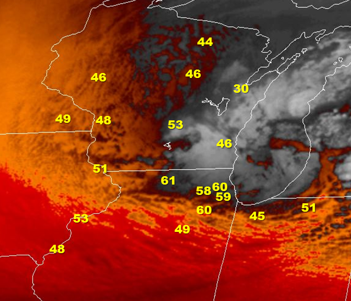 |
| Peak wind gusts at select automated observation sites | Peak wind gusts overlaid on late morning satellite water vapor imagery |
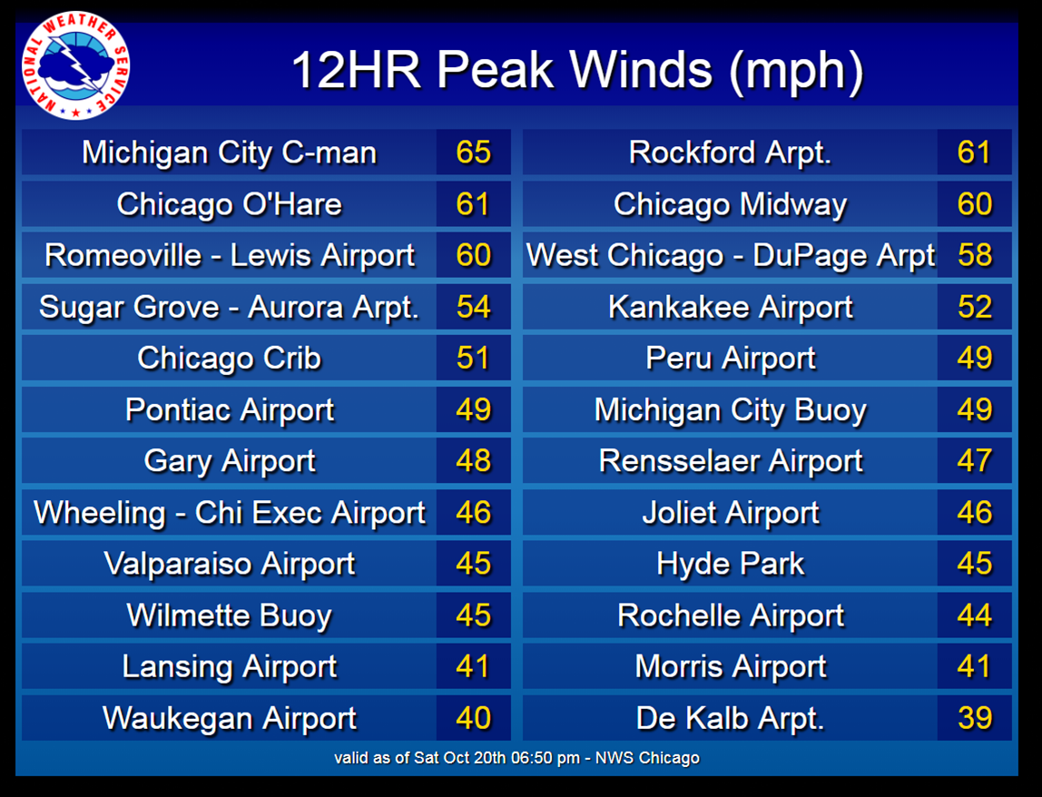
Peak Wind Gusts
Public Information Statement
National Weather Service Chicago IL
648 PM CDT Sat Oct 20 2018

...Highest Wind Gusts at Automated Stations on October 20th...

Location                     Speed     Time/Date       Provider
Michigan City C-man          65 MPH    0534 PM 10/20   MARITIME
Rockford Arpt.               61 MPH    1246 PM 10/20   ASOS
Chicago OHare                61 MPH    0137 PM 10/20   ASOS
Chicago Midway               60 MPH    0156 PM 10/20   ASOS
Romeoville - Lewis Airport   60 MPH    0155 PM 10/20   AWOS
3 N Poplar Grove             59 MPH    0200 PM 10/20   CWOP
West Chicago - DuPage Arpt   58 MPH    0128 PM 10/20   ASOS
2 W Mount Morris             55 MPH    0200 PM 10/20   CWOP
Sugar Grove - Aurora Arpt.   54 MPH    0300 PM 10/20   ASOS
3 ENE Roscoe                 53 MPH    0241 PM 10/20   CWOP
Waukegan Harbor              53 MPH    0230 PM 10/20   NWS-GLOS
Kankakee Airport             52 MPH    0235 PM 10/20   AWOS
Chicago Crib                 51 MPH    0410 PM 10/20   MARITIME
1 SE Winnebago               51 MPH    0240 PM 10/20   CWOP
Peotone                      51 MPH    0220 PM 10/20   CWOP
Michigan City Buoy           49 MPH    0530 PM 10/20   MARITIME
Pontiac Airport              49 MPH    0115 PM 10/20   AWOS
Peru Airport                 49 MPH    0115 PM 10/20   AWOS
Burns Harbor                 48 MPH    0510 PM 10/20   NWS-GLOS
Gary Airport                 48 MPH    0345 PM 10/20   AWOS
5 E Ashkum                   47 MPH    0252 PM 10/20   CWOP
1 SW Saint Charles           47 MPH    0145 PM 10/20   CWOP
Rensselaer Airport           47 MPH    0315 PM 10/20   AWOS
Rosemont                     46 MPH    0145 PM 10/20   CWOP
Wheeling - Chi Exec Airport  46 MPH    0324 PM 10/20   ASOS
2 W Huntley                  46 MPH    0228 PM 10/20   CWOP
Joliet Airport               46 MPH    0215 PM 10/20   AWOS
2 NW Bolingbrook             45 MPH    0310 PM 10/20   CWOP
Hyde Park                    45 MPH    0215 PM 10/20   NONFEDAWOS
Valparaiso Airport           45 MPH    1217 PM 10/20   ASOS
Wilmette Buoy                45 MPH    0310 PM 10/20   MARITIME
2 NE Bradley                 45 MPH    0238 PM 10/20   CWOP
Rochelle Airport             44 MPH    0235 PM 10/20   AWOS
4 ESE Beecher                43 MPH    0230 PM 10/20   CWOP
1 NNE Crystal Lake           43 MPH    0214 PM 10/20   CWOP
1 NNW Woodridge              42 MPH    0146 PM 10/20   CWOP
2 WNW Dixon                  42 MPH    0239 PM 10/20   CWOP
Mount Prospect               42 MPH    0130 PM 10/20   MESOWEST
1 ENE Bonfield               42 MPH    0230 PM 10/20   CWOP
Morris Airport               41 MPH    1215 PM 10/20   AWOS
2 N Utica                    41 MPH    0301 PM 10/20   CWOP
1 W Gibson City              41 MPH    0312 PM 10/20   CWOP
2 W Geneva                   41 MPH    0245 PM 10/20   MESOWEST
1 NNE Wonder Lake            41 MPH    1255 PM 10/20   CWOP
Lansing Airport              41 MPH    0235 PM 10/20   AWOS
Frankfort                    40 MPH    0213 PM 10/20   CWOP
1 ENE Logan Square           40 MPH    0154 PM 10/20   URBANET
Lansing                      40 MPH    0229 PM 10/20   URBANET
2 N Shorewood                40 MPH    0324 PM 10/20   CWOP
Porter                       40 MPH    0317 PM 10/20   RAWS
Waukegan Airport             40 MPH    1106 AM 10/20   ASOS
De Kalb Arpt.                39 MPH    1035 AM 10/20   AWOS

Observations are collected from a variety of sources with varying
equipment and exposures. Not all data listed are considered official.

$$
Photos:
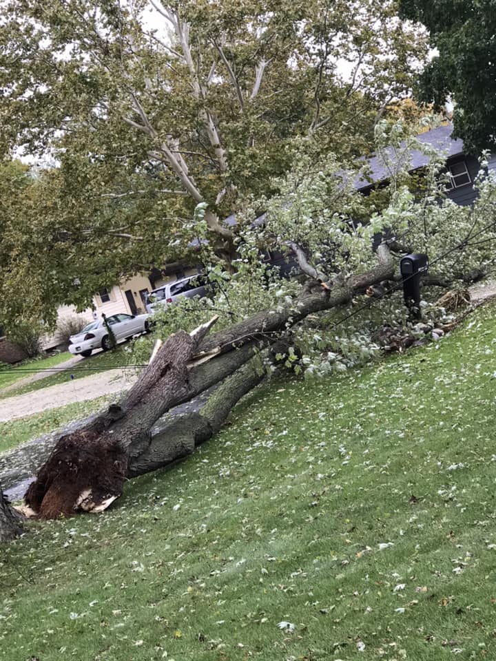 |
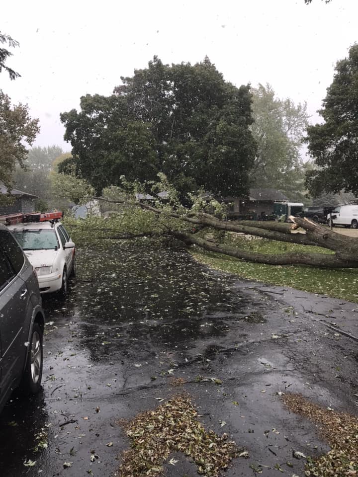 |
 |
 |
 |
 |
| Sycamore, IL Emily Kerkett James via Bob Wazsak |
Sycamore, IL Josh James via Bob Wazsak |
Somonauk, IL Bob Wazsak |
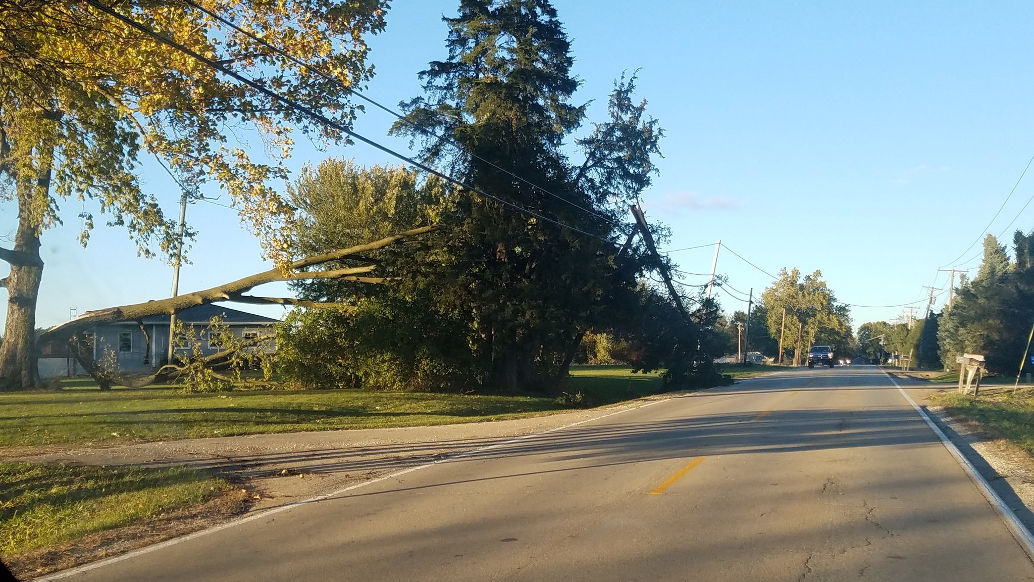
St. Charles/ Campton Hills Geri Wilson via Bob Wazsak |
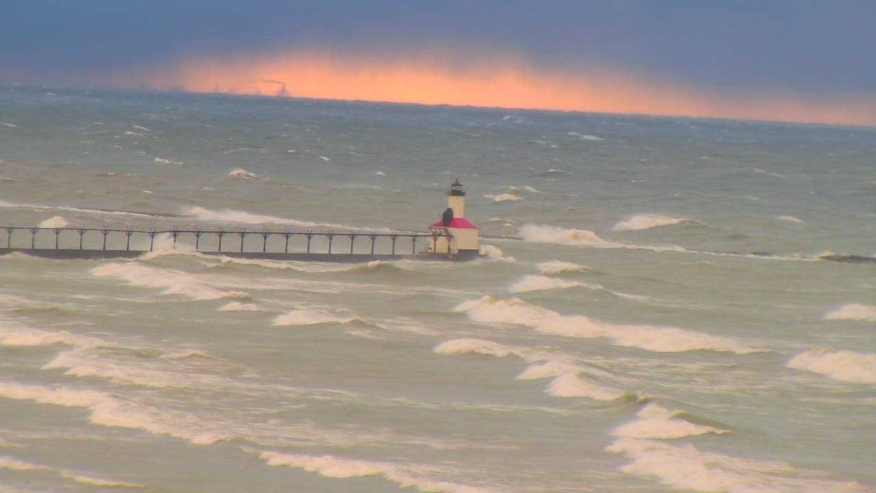
Michigan City, IN beach webcam at 5:30 pm CDT showing large waves |
Westchester, IL |
Radar:
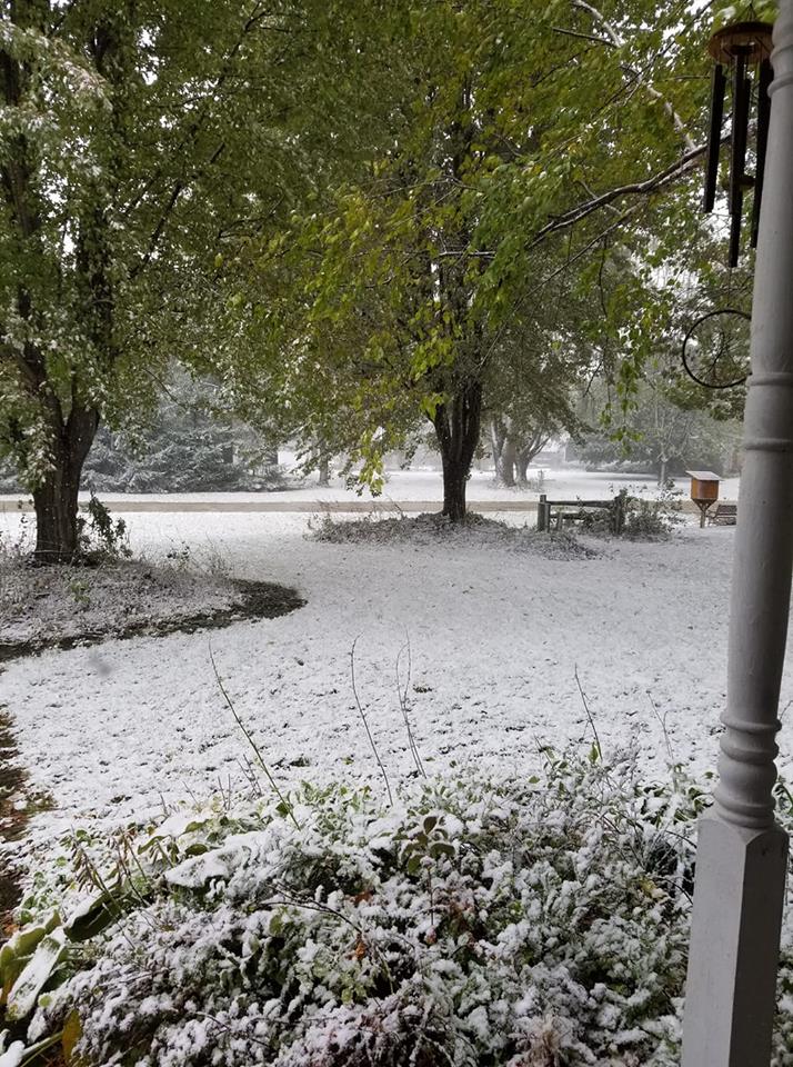
Fast-Moving Snow Squalls, Mixed With Graupel and Rain
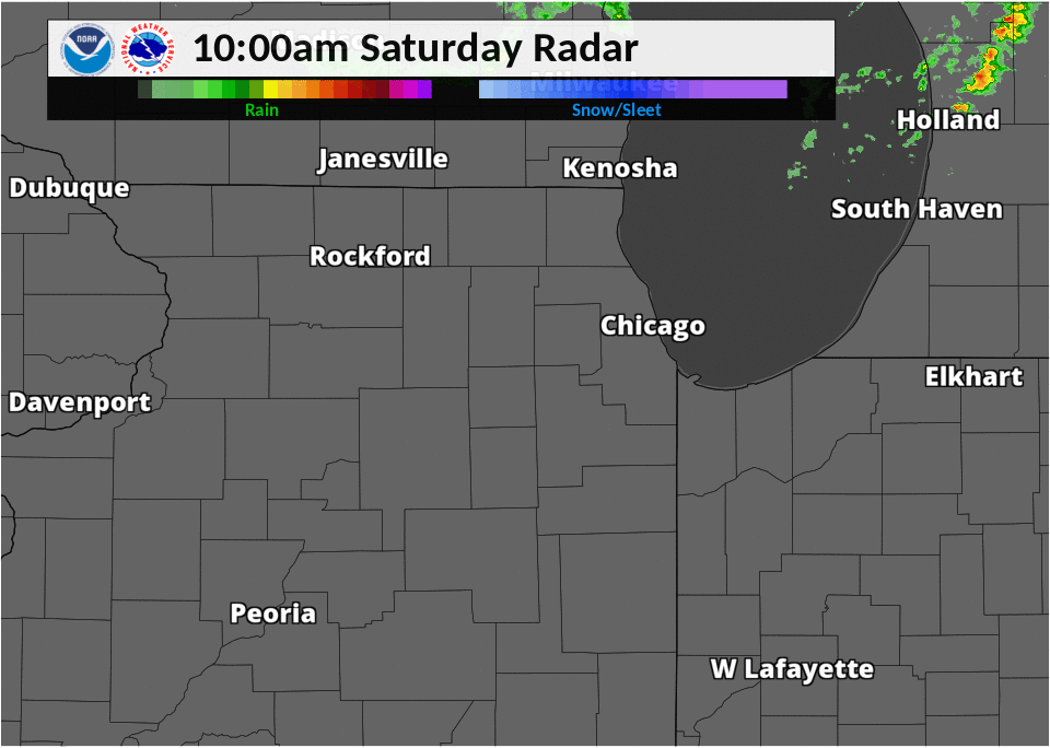 |
| Radar Mosaic Loop from 10am to 4pm CDT. While the colors indicate rain, the heavier areas were leading to rapid cooling of the atmosphere, allowing for snow and/or graupel to reach the ground. |
Storm Reports
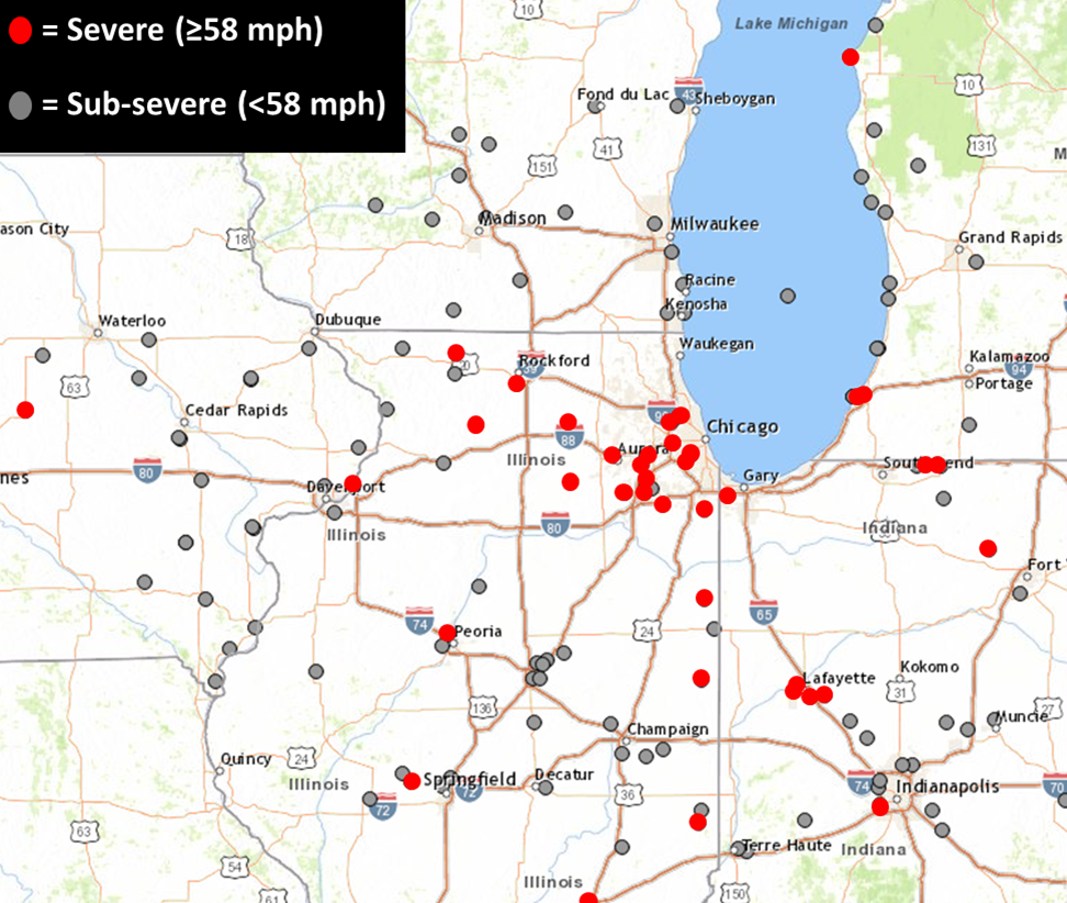 |
| Storm reports of strong and damaging winds. |
PRELIMINARY LOCAL STORM REPORT...SUMMARY
NATIONAL WEATHER SERVICE CHICAGO/ROMEOVILLE IL
625 PM CDT SAT OCT 20 2018

..TIME...   ...EVENT...      ...CITY LOCATION...     ...LAT.LON...
..DATE...   ....MAG....      ..COUNTY LOCATION..ST.. ...SOURCE....
            ..REMARKS..

0415 PM     NON-TSTM WND DMG SHELDON                 40.77N 87.57W
10/20/2018                   IROQUOIS           IL   EMERGENCY MNGR

            SIDING BLOWN OFF ON THE WEST SIDE OF A RESIDENCE.

0320 PM     NON-TSTM WND DMG 4 SW PLAINFIELD         41.57N 88.26W
10/20/2018                   KENDALL            IL   PUBLIC

            2 SMALL TREES DOWNED IN FAR SOUTHWEST PLAINFIELD. RELAYED
            VIA TWITTER.

0304 PM     NON-TSTM WND GST SOMONAUK                41.63N 88.68W
10/20/2018  M65.00 MPH       DE KALB            IL   TRAINED SPOTTER

            RECORDED ON HOME WEATHER STATION. WIND KNOCKED OVER
            FENCE. REPORT RELAYED VIA TWITTER.

0255 PM     NON-TSTM WND DMG BEAVERVILLE             40.95N 87.65W
10/20/2018                   IROQUOIS           IL   PUBLIC

            LARGE TREE BRANCH BROKEN OFF...RELAYED VIA ILX FACEBOOK.

0224 PM     NON-TSTM WND DMG HIGHLAND                41.55N 87.46W
10/20/2018                   LAKE               IN   TRAINED SPOTTER

            LARGE TREE LIMBS ESTIMATED 7 INCH DIAMTER DOWN ON RIDGE
            ROAD AND INDIANAPOLIS AT WICKER PARK.

0220 PM     NON-TSTM WND DMG STEGER                  41.47N 87.64W
10/20/2018                   WILL               IL   EMERGENCY MNGR

            MULTIPLE TREES DOWN/SNAPPED...SOME ACROSS ROADS AND ONE
            THAT DAMAGED A HOUSE. TIME ESTIMATED.

0211 PM     NON-TSTM WND DMG PARK RIDGE              42.01N 87.84W
10/20/2018                   COOK               IL   PUBLIC

            VERY LARGE DISEASED TREE SNAPPED. RELAYED VIA TWITTER.

0210 PM     NON-TSTM WND DMG SOMONAUK                41.63N 88.68W
10/20/2018                   DE KALB            IL   TRAINED SPOTTER

            MEDIUM SIZE TREE APPROX 8 TO 12 INCH DIAMETER UPROOTED.
            TIME ESTIMATED.

0200 PM     NON-TSTM WND DMG CREST HILL              41.57N 88.11W
10/20/2018                   WILL               IL   TRAINED SPOTTER

            LARGE TREE UPROOTED ON RT 53 IN CREST HILL. ROOT SYSTEM
            LIFTED UP UNDERNEATH GARAGE LIFTING GARAGE OFF FOUNDATION
            CAUSING EXTENSIVE DAMAGE TO BUILDING. PICTURE VIA
            TWITTER. TIME ESTIMATED.

0157 PM     NON-TSTM WND GST ROMEOVILLE              41.65N 88.09W
10/20/2018  M55.00 MPH       WILL               IL   OFFICIAL NWS OBS

            HEAVY SNOW SQUALL WITH 55 MPH WIND AND APPROX 1/4 MILE
            VISIBILITY AT NWS CHICAGO.

0156 PM     NON-TSTM WND GST MIDWAY AIRPORT          41.78N 87.75W
10/20/2018  M60.00 MPH       COOK               IL   ASOS

            RAIN/SNOW SQUALL.

0155 PM     NON-TSTM WND GST 3 SW MIDWAY AIRPORT     41.75N 87.79W
10/20/2018  M63.00 MPH       COOK               IL   CO-OP OBSERVER

            MEASURED 63 MPH WIND GUST WITH RAIN/SNOW SQUALL.

0155 PM     NON-TSTM WND GST 3 WNW LOCKPORT          41.61N 88.10W
10/20/2018  M60.00 MPH       WILL               IL   AWOS

            60 MPH WIND MEASURED AT KLOT.

0152 PM     NON-TSTM WND DMG LOCKPORT                41.59N 88.05W
10/20/2018                   WILL               IL   PUBLIC

            LARGE TREE BRANCH SNAPPED OFF AND FELL ONTO A GARAGE.
            RELAYED VIA TWITTER. TIME ESTIMATED BY RADAR.

0140 PM     NON-TSTM WND DMG LISLE                   41.79N 88.09W
10/20/2018                   DUPAGE             IL   TRAINED SPOTTER

            LARGE TREE 12 TO 18 INCHES IN DIAMETER AND 8 TO 10 INCH
            DIAMETER TREE BRANCHES DOWNED ON A PRIVATE PROPERTY.
            REPORTED RELAYED VIA TWITTER. TIME ESTIMATED BY RADAR.

0140 PM     NON-TSTM WND DMG WESTCHESTER             41.85N 87.89W
10/20/2018                   COOK               IL   PUBLIC

            LARGE TREE APPOX 12-18 INCH DIAMETER UPROOTED IN
            WESTCHESTER. TIME ESTIMATED FROM RADAR.

0138 PM     NON-TSTM WND DMG 3 WNW AURORA            41.78N 88.35W
10/20/2018                   KANE               IL   NWS EMPLOYEE

            WIND DOWNED POWER LINE NEAR INDIAN TRAIL ROAD AND RANDALL
            ROAD.

0137 PM     NON-TSTM WND DMG 3 NW BOLINGBROOK        41.73N 88.13W
10/20/2018                   DUPAGE             IL   PUBLIC

            MEDIUM TO LARGE SIZED TREE LIMBS DOWN ON SOME PROPERTIES
            IN NAPER CARRIAGE HILL SUBDIVISION OF NAPERVILLE. TIME
            ESTIMATED BY RADAR.

0137 PM     NON-TSTM WND GST OHARE AIRPORT           41.98N 87.90W
10/20/2018  M61.00 MPH       COOK               IL   ASOS

            NO LIGHTNING PRESENT BUT GUST OCCURRED WITH RAIN SHOWER.

0120 PM     NON-TSTM WND DMG SYCAMORE                41.98N 88.70W
10/20/2018                   DE KALB            IL   PUBLIC

            LARGE TREES DOWNED BLOCKING SOME STREETS AND TOOK DOWN
            POWER LINES. RELAYED VIA TWITTER.

0105 PM     NON-TSTM WND DMG CRYSTAL LAKE            42.23N 88.33W
10/20/2018                   MCHENRY            IL   PUBLIC

            SCATTERED MEDIUM TO LARGE TREE BRANCHES DOWN NEAR CRYSTAL
            LAKE HIGH SCHOOL. RELAYED VIA FACEBOOK.

0105 PM     NON-TSTM WND DMG 5 SW OREGON             41.96N 89.41W
10/20/2018                   OGLE               IL   TRAINED SPOTTER

            LARGE TREED UPROOTED ACROSS RIDGE ROAD NEAR HENRY ROAD.
            TIME ESTIMATED.

1252 PM     SNOW             CRYSTAL LAKE            42.23N 88.33W
10/20/2018  E0.0 INCH        MCHENRY            IL   CO-OP OBSERVER

            SNOW SHOWERS WITH STRONG WIND GUSTS.

1246 PM     NON-TSTM WND GST ROCKFORD AIRPORT        42.20N 89.10W
10/20/2018  M61.00 MPH       WINNEBAGO          IL   ASOS

            NO LIGHTNING BUT CONVECTIVELY INDUCED WIND GUST WITH RASN
            SQ REPORTED.

1115 AM     NON-TSTM WND DMG CRYSTAL LAKE            42.23N 88.33W
10/20/2018                   MCHENRY            IL   TRAINED SPOTTER

            APPROX 3 INCH DIAMETER TREE LIMB DOWN NEAR CRYSTAL LAKE
            HIGH SCHOOL. ANOTHER LIMB DOWN ON POWER LINE ALSO NEAR
            HIGH SCHOOL.


&&

$$

RC
Marine/Hydrology
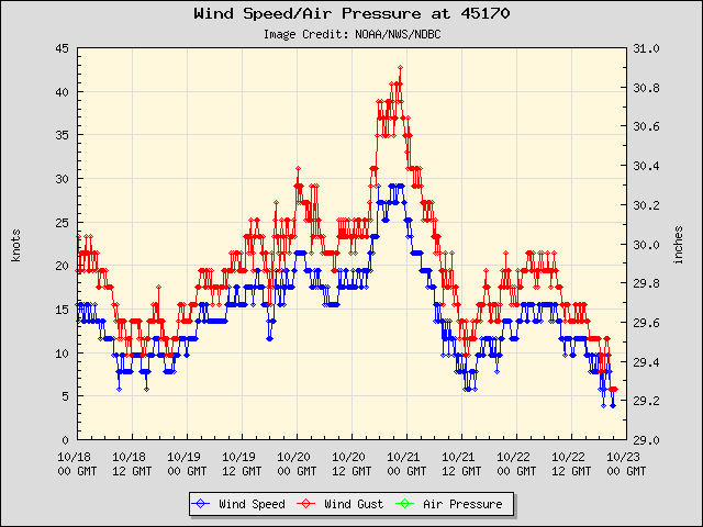 |
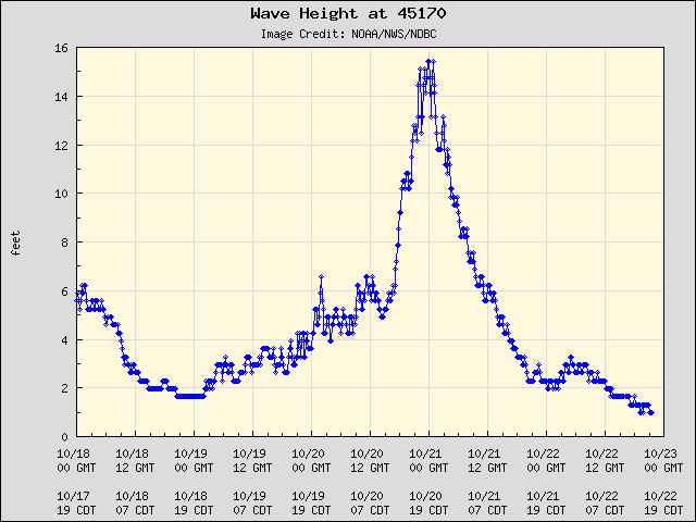 |
| Figure 1: Observed sustained winds and gusts at Michigan City. | Figure 2: Observed waves at Michigan City. |
 |
 |
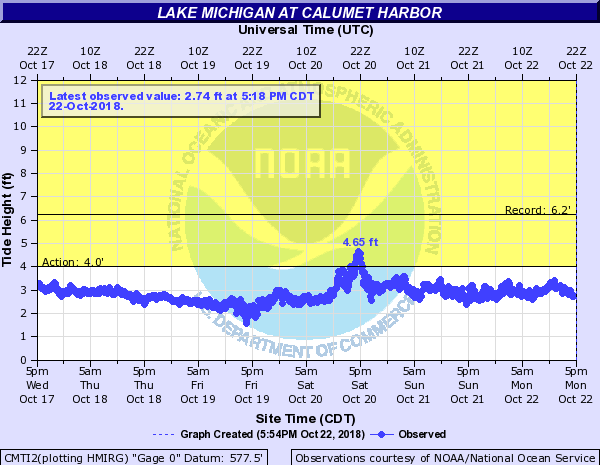 |
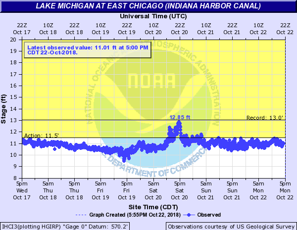
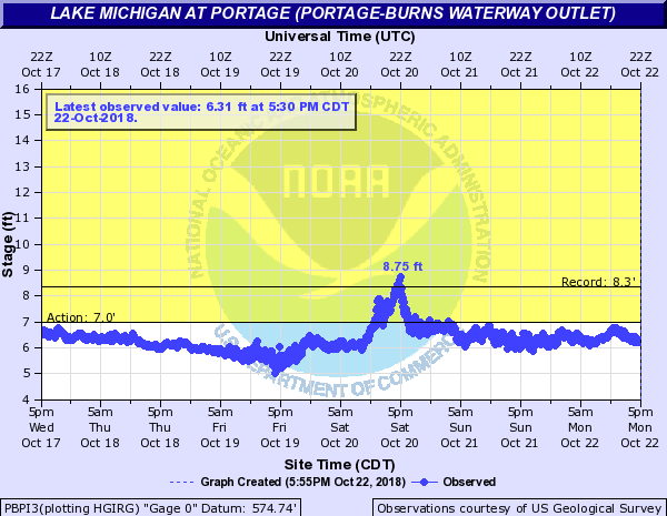
| Figure 3: Observed Indiana Harbor Canal water level. | Figure 4: Observed Portage Burns Water Outlet level. | Figure 5: Observed Calumet Harbor water level. |
Meteorology
 |
 |
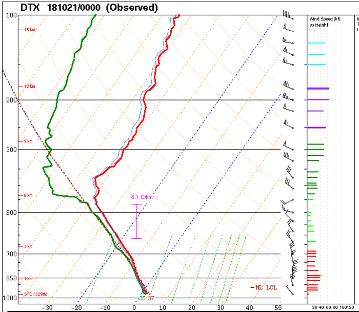 |
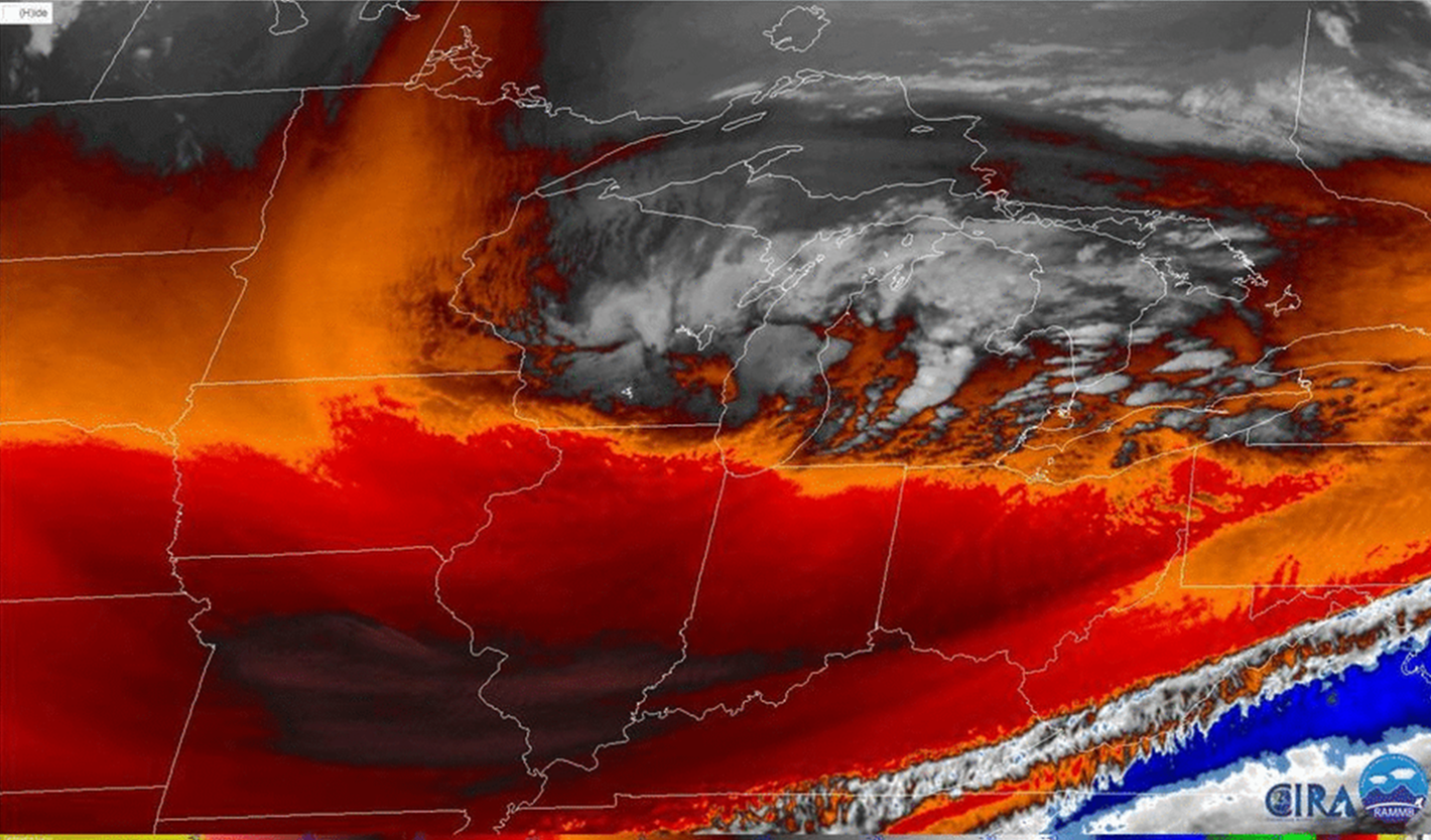
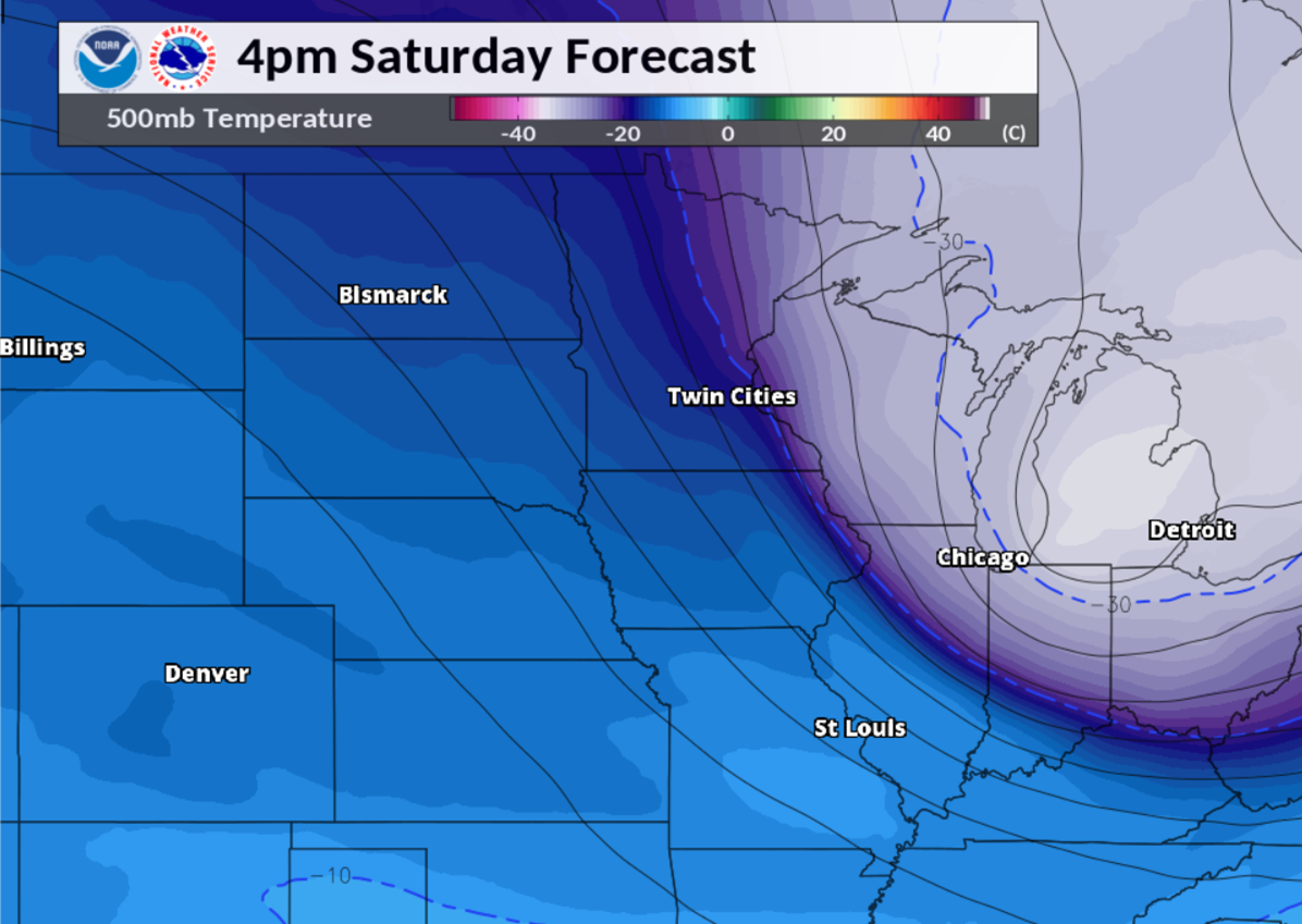
| Figure 1: Water vapor imagery from late morning, showing the well-defined broad twist (upper low), as well as a concentrated smaller embedded circulation in southern Wisconsin moving southeast. | Figure 2: Model analysis of 500 mb (~18,000 ft) temperatures, indicating the substantial cold air at that level rotating across the Great Lakes region. | Figure 3: NWS Detroit weather balloon data plot from 7 pm on Saturday evening. This atmosphere was fairly representative of northeast Illinois and northwest Indiana during the afternoon. The cold mid-level (500 mb) temperatures are sampled, helping to generate steep lapse rates. This Moist Absolute Unstable Layer (MAUL) meant that little forcing was needed for convective updrafts for the snow/graupel squalls. |
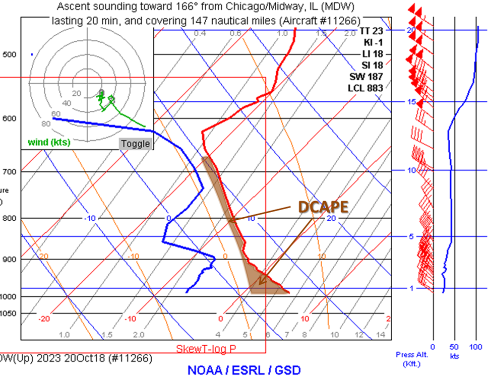 |
| Figure 4: Aircraft sounding from Chicago Midway. Similar to Figure 3, there are steep lapse rates and ample moisture in the convective cloud depth. Also highlighted is Downdraft Convective Available Potential Energy (DCAPE), a strong proxy for downdraft strength. This additional factor helped produce the severe wind gusts. |
Additional Information
 |
Media use of NWS Web News Stories is encouraged! Additional recaps can be found on the NWS Chicago Past Events Page |
|

