Scattered thunderstorms with severe gusts, hail and a tornado risk are possible near a cold front from the Ohio Valley to the Mid-Atlantic tonight. Tropical Storm Bertha is expected to bring tropical storm conditions to portions of the Gulf Coast from the panhandle of Florida into Louisiana through Wednesday. Read More >
|
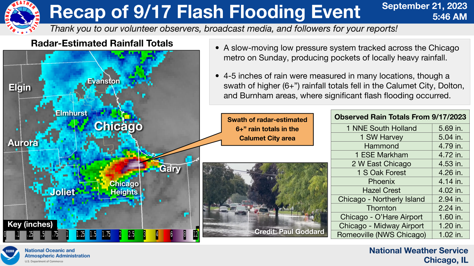
Overview graphic |
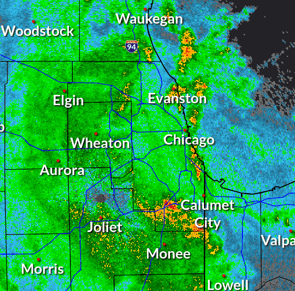
Radar loop from 4:30 AM to 2:30 PM CDT on Sunday, September 17 |
Fast Facts
For detailed information about this event, see The July 2 and September 17, 2023, Flash Flood Events in the Chicago Metro Area, a NWS Technical Paper which details the rainfall, flooding, and impacts.
Rainfall Reports
 |
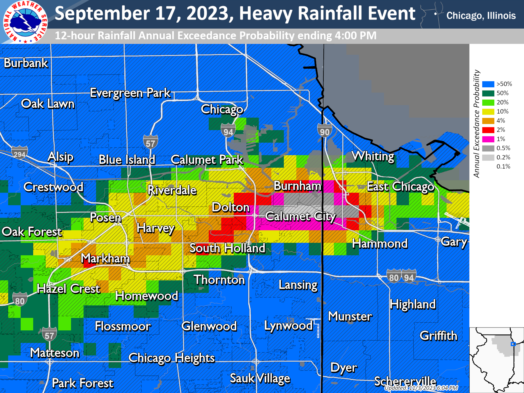 |
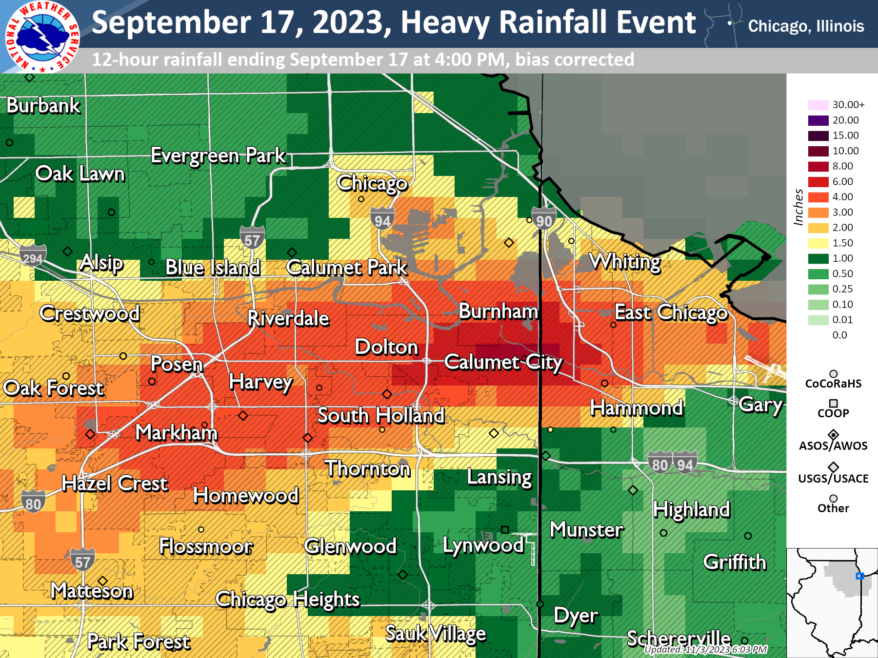
| Bias-corrected radar rainfall totals (4:00 AM to 4:00 PM) with rain gauges overlaid | The estimated annual exceedance probability for the bias-corrected rainfall. |
Location                     Amount    Time/Date       Provider

...Illinois...

...Cook County...
1 NNE South Holland          5.69 in   0500 PM 09/17   Mesonet
1 SW Harvey                  5.04 in   0500 PM 09/17   Mesonet
1 ESE Markham                4.72 in   0500 PM 09/17   Mesonet
1 SE Midlothian              4.47 in   0700 AM 09/18   CoCoRaHs
1 SE Harvey                  4.35 in   0500 PM 09/17   Mesonet
1 S Oak Forest               4.26 in   0500 PM 09/17   Mesonet
Phoenix                      4.14 in   0300 PM 09/17   Mesonet
Hazel Crest                  4.02 in   0325 AM 09/18   AWS
2 WNW Chicago Loop           3.15 in   1200 PM 09/17   Mesonet
Homewood                     2.96 in   0700 AM 09/18   CoCoRaHs
Chicago - Northerly Island   2.94 in   0325 AM 09/18   AWS
Oak Forest                   2.87 in   0700 AM 09/18   CoCoRaHs
2 SW Lincoln Park - Chicago  2.85 in   0317 AM 09/18   CWOP
Midlothian                   2.78 in   0700 AM 09/18   CoCoRaHs
1 ESE Flossmoor              2.76 in   0700 AM 09/18   CoCoRaHs
2 SE Tinley Park             2.71 in   0319 AM 09/18   CWOP
Chicago Loop                 2.69 in   0325 AM 09/18   AWS
1 ESE Roseland - Chicago     2.65 in   0200 PM 09/17   Mesonet
1 SSW La Grange Park         2.58 in   0700 AM 09/18   CoCoRaHs
Oak Park                     2.52 in   0318 AM 09/18   CWOP
1 S Westchester              2.44 in   0300 PM 09/17   Mesonet
1 WNW La Grange Park         2.44 in   0516 PM 09/17   Public
2 NNW Chicago Heights        2.32 in   0700 AM 09/18   CoCoRaHs
1 NNE Oak Park               2.29 in   0700 AM 09/18   CoCoRaHs
1 E Matteson                 2.25 in   0700 AM 09/18   CoCoRaHs
Thornton                     2.24 in   0400 PM 09/17   Mesonet
Westchester                  2.22 in   0300 PM 09/17   Mesonet
1 SW Westchester             2.12 in   0300 PM 09/17   Mesonet
2 N Hegeswisch - Chicago     2.11 in   0500 PM 09/17   Mesonet
1 S Arlington Heights        2.09 in   0700 AM 09/18   CoCoRaHs
Elk Grove Village            2.07 in   0700 AM 09/18   CoCoRaHs
1 NNE Palatine               2.06 in   0700 AM 09/18   CoCoRaHs
1 WNW Park Forest            1.98 in   0700 AM 09/18   CoCoRaHs
Franklin Park                1.85 in   0319 AM 09/18   CWOP
South Holland                1.85 in   0325 AM 09/18   AWS
2 NNE Tinley Park            1.71 in   0325 AM 09/18   AWS
Chicago - O`Hare Airport     1.60 in   0251 AM 09/18   ASOS
Chicago                      1.59 in   0317 AM 09/18   CWOP
River Forest                 1.59 in   0325 AM 09/18   AWS
1 SW Palos Park              1.59 in   0700 AM 09/18   CoCoRaHs
Hoffman Estates              1.55 in   0315 AM 09/18   CWOP
Riverside - Des Plaines R.   1.46 in   0245 AM 09/18   HADS
1 N Norridge                 1.46 in   0315 AM 09/18   CWOP
Rolling Meadows              1.45 in   0318 AM 09/18   CWOP
1 ESE Wheeling               1.44 in   0325 AM 09/18   AWS
1 S Lincoln Park - Chicago   1.44 in   0325 AM 09/18   AWS
Chicago - Hyde Park          1.43 in   0700 AM 09/18   CoCoRaHs
La Grange                    1.42 in   0300 AM 09/18   CWOP
Burr Ridge                   1.42 in   0303 AM 09/18   CWOP
Orland Park                  1.35 in   0315 AM 09/18   CWOP
1 SSE Lincoln Park - Chicago 1.34 in   0325 AM 09/18   AWS
Wheeling - Chicago Exec. Arp 1.22 in   0252 AM 09/18   ASOS
Chicago - Midway Airport     1.20 in   0253 AM 09/18   ASOS
Chicago - McKinley Park      1.18 in   0325 AM 09/18   URBANET
Glenwood                     1.14 in   0315 AM 09/18   CWOP
Chicago                      1.13 in   0310 AM 09/18   CWOP
Chicago                      1.10 in   0315 AM 09/18   CWOP
Harwood Heights              1.07 in   0325 AM 09/18   AWS
1 WNW Logan Square           1.06 in   0324 AM 09/18   URBANET
Hickory Hills                1.05 in   0311 AM 09/18   CWOP
Inverness                    1.03 in   0315 AM 09/18   CWOP
1 SSE East Hazel Crest       1.00 in   0325 AM 09/18   AWS

...DuPage County...
Oak Brook - Salt Cr.         2.51 in   0300 AM 09/18   HADS
1 NNE Hinsdale               2.40 in   1200 PM 09/17   Mesonet
2 SE Elmhurst                2.33 in   0700 AM 09/18   CoCoRaHs
Salt Cr. - Elmhurst          2.13 in   0320 AM 09/18   HADS
1 NW Villa Park              1.95 in   0700 AM 09/18   CoCoRaHs
1 ESE Villa Park             1.94 in   0700 AM 09/18   CoCoRaHs
Burr Ridge                   1.76 in   0317 AM 09/18   CWOP
Wheaton                      1.60 in   0320 AM 09/18   CWOP
4 S Glen Ellyn               1.59 in   0400 PM 09/17   COOP
2 SW Burr Ridge              1.45 in   0700 AM 09/18   CoCoRaHs
Bensenville                  1.35 in   0325 AM 09/18   AWS
2 S Glen Ellyn               1.19 in   0324 AM 09/18   AWS
Naperville                   1.08 in   0316 AM 09/18   CWOP
York Center                  1.07 in   0325 AM 09/18   URBANET
0.7 NW Wood Dale             1.02 in   0305 AM 09/18   HADS
Woodridge                    1.01 in   0315 AM 09/18   CWOP

...Kankakee County...
Grant Park                   1.09 in   0315 AM 09/18   CWOP

...Lake County...
2 WSW Lake Forest            2.04 in   0700 AM 09/18   CoCoRaHs
1 ESE Buffalo Grove          1.97 in   0700 AM 09/18   CoCoRaHs
Bannockburn                  1.92 in   0700 AM 09/18   CoCoRaHs
2 NNE Lake Forest            1.91 in   0700 AM 09/18   CoCoRaHs
Libertyville                 1.90 in   0700 AM 09/18   CoCoRaHs
1 S Highwood                 1.87 in   0700 AM 09/18   CoCoRaHs
Deerfield - W. Fork N. Br. C 1.82 in   0310 AM 09/18   HADS
1 N Lake Zurich              1.70 in   0700 AM 09/18   CoCoRaHs
1 W Lake Bluff               1.66 in   0700 AM 09/18   CoCoRaHs
Lake Forest                  1.55 in   0315 AM 09/18   CWOP
Deerfield                    1.51 in   0315 AM 09/18   CWOP
Lake Bluff                   1.33 in   0316 AM 09/18   CWOP
Deerfield - N. Br. Chicago R 1.30 in   0310 AM 09/18   HADS
Vernon Hills                 1.26 in   0316 AM 09/18   CWOP
Gurnee - Des Plaines R.      1.23 in   0230 AM 09/18   HADS
Libertyville                 1.21 in   0317 AM 09/18   CWOP
Zion                         1.11 in   0315 AM 09/18   CWOP

...Will County...
1 ESE Frankfort              1.94 in   0700 AM 09/18   CoCoRaHs
3 WNW Mokena                 1.94 in   0700 AM 09/18   CoCoRaHs
5 ENE Manhattan              1.68 in   0700 AM 09/18   CoCoRaHs
2 SW Mokena                  1.62 in   0700 AM 09/18   CoCoRaHs
Frankfort                    1.58 in   0315 AM 09/18   CWOP
1 ENE Homer Glen             1.46 in   0700 AM 09/18   CoCoRaHs
3 SE New Lenox               1.45 in   0700 AM 09/18   CoCoRaHs
Homer Glen                   1.35 in   0319 AM 09/18   CWOP
New Lenox                    1.25 in   0315 AM 09/18   CWOP

...Indiana...

...Lake County...
Hammond                      4.79 in   0700 AM 09/18   CoCoRaHs
2 W East Chicago             4.53 in   0400 PM 09/17   Mesonet
1 N Hammond                  4.36 in   0325 AM 09/18   URBANET
1 W Whiting                  1.93 in   0300 PM 09/17   Mesonet
1 NW Hammond                 1.90 in   0600 PM 09/17   Mesonet
East Chicago - IN Harbor Can 1.12 in   0300 AM 09/18   HADS
1 WNW Dyer                   1.11 in   0700 AM 09/18   CoCoRaHs

Observations are collected from a variety of sources with varying
equipment and exposures. We thank all volunteer weather observers
for their dedication. Not all data listed are considered official.
Flooding Reports
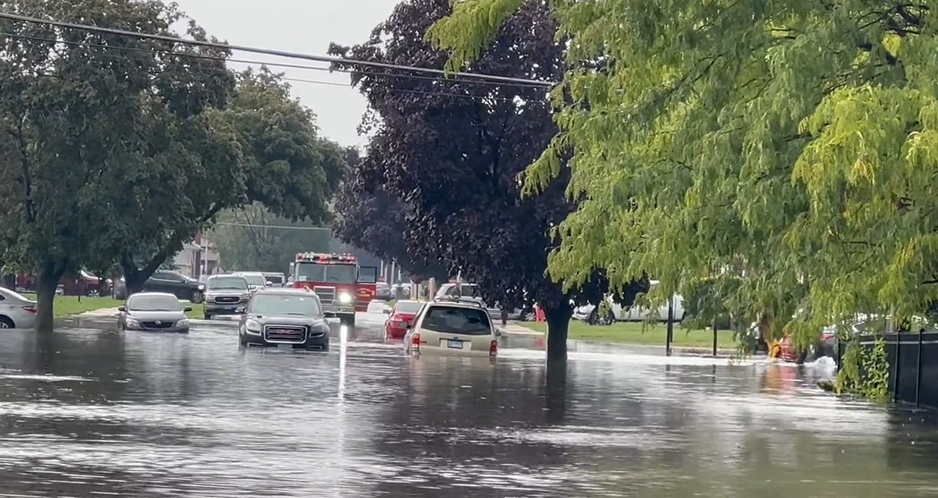 |
 |
| Flooding in Calumet City. Courtesy of Paul Goddard. | Flooding in Calumet City. Courtesy of Paul Goddard. |
Preliminary Local Storm Report...Summary
National Weather Service Chicago IL
746 AM CDT Mon Sep 18 2023

..TIME...   ...EVENT...      ...CITY LOCATION...     ...LAT.LON...
..DATE...   ....MAG....      ..COUNTY LOCATION..ST.. ...SOURCE....
            ..REMARKS..

0841 AM     Flash Flood      2 WNW Chicago Loop      41.89N 87.67W
09/17/2023                   Cook               IL   Public

            Report on social media of a flooded viaduct
            on Ashland Avenue between Hubbard and Lake
            Streets with report of a car under water.

1006 AM     Flash Flood      1 SSE Dolton            41.61N 87.59W
09/17/2023                   Cook               IL   Public

            Corrects previous flood report from 1 SSE
            Dolton. mPING Report: River/Creek
            overflowing; Yard/Basement Flooding.

1019 AM     Flash Flood      Homewood                41.56N 87.66W
09/17/2023                   Cook               IL   Public

            Corrects previous flood report from
            Homewood. Report from mPING: River/Creek
            overflowing; Yard/Basement Flooding.

1025 AM     Flash Flood      1 NNW Glenwood          41.55N 87.62W
09/17/2023                   Cook               IL   Public

            Corrects previous flood report from 1 NNW
            Glenwood. River/Creek overflowing;
            Yard/Basement Flooding.

1100 AM     Flash Flood      1 ESE Dolton            41.62N 87.57W
09/17/2023                   Cook               IL   Fire Dept/Rescue

            Multiple water rescues, including one with 6
            people rescued after being trapped in their
            vehicle in flood waters.

1135 AM     Flash Flood      2 E West Pullman - Chic 41.67N 87.60W
09/17/2023                   Cook               IL   Public

            Report on social media of flooded viaducts
            at 130th and Torrence as well as 130th and
            Doty with cars in water.

1224 PM     Flash Flood      Homewood                41.56N 87.66W
09/17/2023                   Cook               IL   Public

            Street/road flooding; Street/road closed;
            Vehicles stranded.

1229 PM     Flash Flood      1 SSE Dolton            41.61N 87.59W
09/17/2023                   Cook               IL   Public

            River/Creek overflowing; Yard/Basement
            Flooding.

1235 PM     Flash Flood      1 SW Burnham            41.62N 87.56W
09/17/2023                   Cook               IL   Public

            Video on social media showed stranded cars
            in moving flooded waters at near Torrence
            and Sibley in Calumet City.

1250 PM     Flash Flood      1 WNW Hegeswisch - Chic 41.66N 87.57W
09/17/2023                   Cook               IL   Law Enforcement

            130th st closed due to flooding from the
            Bishop Ford east to Ford Access Rd just west
            of Torrence Ave.

0100 PM     Flash Flood      2 E West Pullman - Chic 41.67N 87.60W
09/17/2023                   Cook               IL   Broadcast Media

            Corrects previous flood report from 2 E West
            Pullman - Chicago. Local media reported on
            social media police closure at 130th and
            Doty Avenue due to flooding.

0110 PM     Flash Flood      2 ESE Dolton            41.62N 87.57W
09/17/2023                   Cook               IL   Broadcast Media

            Corrects previous flood report from 2 ESE
            Dolton. Local media reported via social
            media of flooding near Sibley Blvd and
            Merrill Avenue in Calumet City.

0130 PM     Flash Flood      1 SE Dolton             41.63N 87.59W
09/17/2023                   Cook               IL   Trained Spotter

            Drone footage shows widespread and
            significant flash flooding across large
            portions of Dolton and Calumet City. Street
            after street after street completely
            submerged with abandoned cars littered about
            in the flood waters. Flood waters reaching
            and surrounding several homes and apartment
            buildings.

&&

$$
 |
Media use of NWS Web News Stories is encouraged! Please acknowledge the NWS as the source of any news information accessed from this site. Additional recaps can be found on the NWS Chicago Past Events Page |
|