Hazardous heat will continue across the Southern Plains, Gulf Coast and Desert Southwest through the weekend. Additional heat will build into the Great Basin and Northern Plains this weekend. A stalled front is expected to bring periods of heavy to excessive rainfall and flooding from the Tennessee Valley to the Southeast U.S on Friday. Read More >
Overview
|
|
For detailed information about the heavy rainfall and flash flooding that impacted the Rockford area, see The July 13-14, 2024, Rockford Flash Floods, a NWS Technical Paper which details the event.
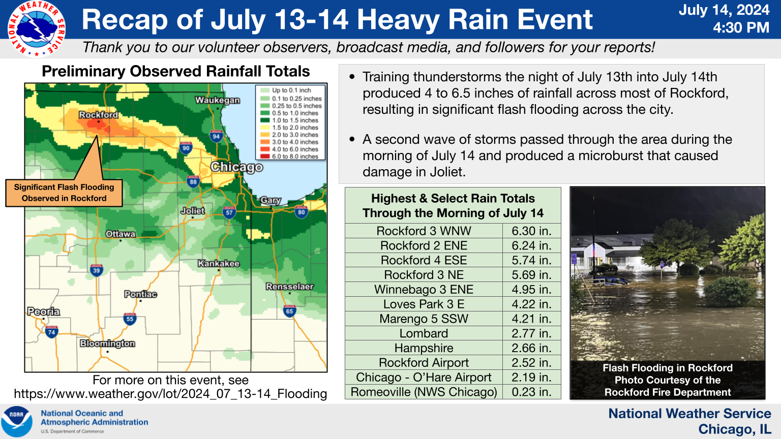
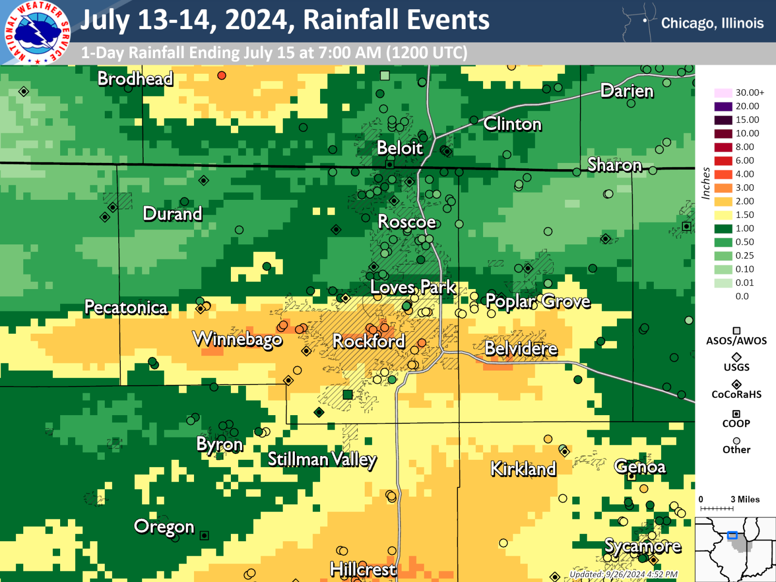
Rainfall
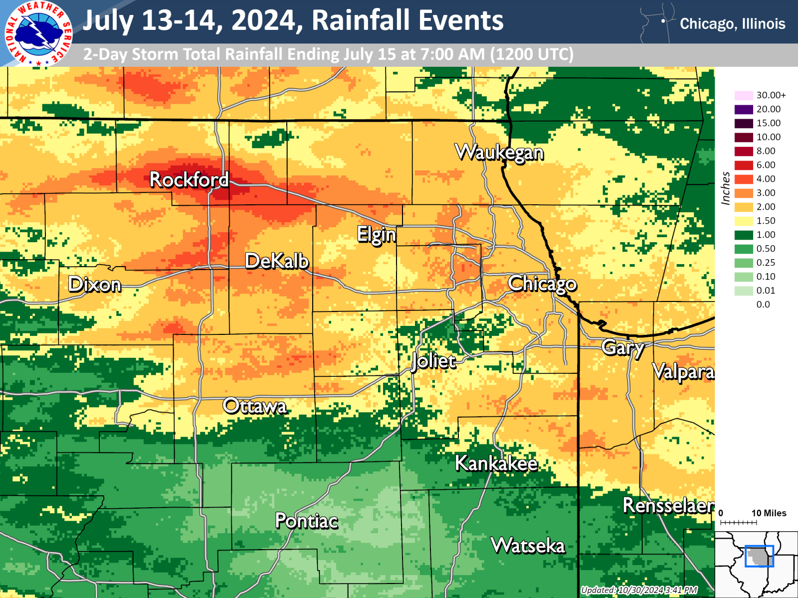
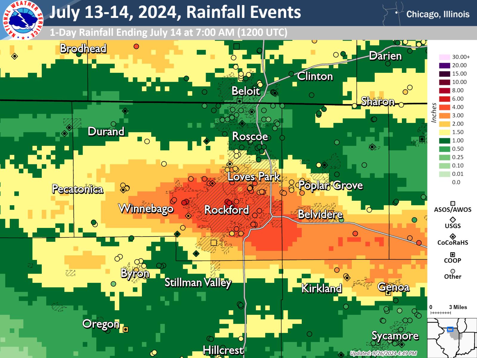
Heavy, flash flood producing rainfall occurred for two nights in a row in the Rockford area. The first period of heavy rainfall occurred during the late evening and overnight hours of July 13 into July 14, 2024, with peak rainfall exceeding 6 inches. The second period of rainfall occurred during the late evening hours of July 14, with peak rainfall exceeding 3 inches. Although the rainfall occurring on the first day was heaviest in the Rockford area, the rainfall on both nights was heavy enough to cause flooding.
Elsewhere across northern Illinois and northwestern Indiana, widespread rainfall amounts of 1-2 inches were recorded.
 |
|
| Bias-corrected rainfall totals for the 2-day period ending at 7:00 AM CDT (1200 UTC) on 15 July, 2024. | |
 |
 |
| Bias-corrected rainfall totals for the 3-hour rainfall occurring in the Rockford area from 10:00 PM to 1:00 AM CDT (0300-0600 UTC) on July 13-14, 2024. | Estimated annual exceedance probability for the 3-hour rainfall occurring in the Rockford area from 10:00 PM to 1:00 AM CDT (0300-0600 UTC) on July 13-14, 2024. |
 |
 |
| Bias-corrected rainfall totals for the 1-hour rainfall occurring in the Rockford area from 8:00 PM to 9:00 PM CDT (0100-0200 UTC) on July 14, 2024. | Estimated annual exceedance probability for the 1-hour rainfall occurring in the Rockford area from 8:00 PM to 9:00 PM CDT (0100-0200 UTC) on July 14, 2024. |
Public Information Statement National Weather Service Chicago IL 330 PM CDT Sun Jul 14 2024 ...7/13-7/14 PRECIPITATION REPORTS... Below is a listing of precipitation reports of 2 or more inches from the evening of Saturday, July 13 through the morning of Sunday, July 14. Location Amount Time/Date Provider ...Illinois... ...Boone County... Herbert 4 N 4.80 in 0900 AM 07/14 Mesonet Timberlane 1 SW 2.33 in 0700 AM 07/14 COCORAHS ...Cook County... La Grange 2.68 in 0300 PM 07/14 CWOP Palatine 1 NNE 2.28 in 0700 AM 07/14 COCORAHS Riverside - Des Plaines R. 2.23 in 0245 PM 07/14 HADS Rolling Meadows 2.23 in 0306 PM 07/14 CWOP La Grange 2.20 in 0308 PM 07/14 CWOP Chicago OHare 2.19 in 0251 PM 07/14 ASOS Chicago Museum Campus 2.19 in 0304 PM 07/14 AWS Chicago Heights 2 NNW 2.11 in 1000 AM 07/14 COCORAHS Lincoln Park - Chicago 2 SW 2.04 in 0307 PM 07/14 CWOP Flossmoor 1 SE 2.03 in 0700 AM 07/14 COCORAHS Lincoln Park - Chicago 2.03 in 0257 PM 07/14 URBANET Hoffman Estates 5 W 2.01 in 0925 AM 07/14 COCORAHS ...De Kalb County... Herbert 3 SW 4.13 in 0900 AM 07/14 Mesonet Genoa 2.31 in 0300 PM 07/14 CWOP Kingston 2 WNW 2.10 in 0700 AM 07/14 COCORAHS ...DuPage County... Salt Cr. - Elmhurst 2.87 in 0220 PM 07/14 HADS Lombard 2.77 in 0700 AM 07/14 COCORAHS Elmhurst 1 SW 2.76 in 0600 AM 07/14 COCORAHS Villa Park 2.54 in 0700 AM 07/14 COCORAHS Wheaton 2.53 in 0305 PM 07/14 CWOP Glen Ellyn 1 W 2.40 in 0700 AM 07/14 COCORAHS Villa Park 1 NW 2.38 in 0600 AM 07/14 COCORAHS Medinah 1 S 2.25 in 0600 AM 07/14 COCORAHS Lombard 2.20 in 0800 AM 07/14 COCORAHS Oak Brook - Salt Cr. 2.19 in 0300 PM 07/14 HADS Elmhurst 2 SE 2.16 in 0700 AM 07/14 COCORAHS Clarendon Hills 2.06 in 0303 PM 07/14 AWS Bloomingdale 1 SSE 2.02 in 0700 AM 07/14 COCORAHS ...Kane County... Hampshire 2.66 in 0700 AM 07/14 COCORAHS Huntley 2.48 in 0305 PM 07/14 CWOP Algonquin 1 SE 2.43 in 0930 AM 07/14 COCORAHS Gilberts 1 NE 2.12 in 0635 AM 07/14 COCORAHS Sleepy Hollow 1 W 2.10 in 0700 AM 07/14 COCORAHS Elgin 6 WNW 2.00 in 1100 AM 07/14 COCORAHS ...Lake County... Hawthorn Woods 2.07 in 0306 PM 07/14 CWOP ...McHenry County... 5 SSW Marengo 4.21 in 0900 AM 07/14 Mesonet Algonquin 2.1 W 2.85 in 0700 AM 07/14 COCORAHS 1 ESE Marengo 2.81 in 0300 PM 07/14 AWS Algonquin 1 NNW 2.73 in 0930 AM 07/14 COCORAHS 1 SSE Lake in the Hills 2.70 in 0630 AM 07/14 COCORAHS Huntley 2 SW 2.40 in 0700 AM 07/14 COCORAHS Marengo 2.33 in 0700 AM 07/14 COCORAHS Algonquin 3.4 W 2.20 in 0600 AM 07/14 COCORAHS ...Winnebago County... 3 WNW Rockford 6.30 in 0900 AM 07/14 Mesonet 2 ENE Rockford 6.24 in 0900 AM 07/14 Public 3 WNW Rockford 6.15 in 0134 AM 07/14 Public 3 WNW Cherry Valley 5.74 in 0900 AM 07/14 Amateur Radio 3 SSE Loves Park 5.69 in 0900 AM 07/14 Mesonet 2 NW Cherry Valley 5.66 in 0900 AM 07/14 Mesonet 2 WSW Cherry Valley 5.54 in 0900 AM 07/14 Mesonet 2 NW Cherry Valley 5.50 in 0312 AM 07/14 Public 1 WNW Cherry Valley 5.39 in 0145 AM 07/14 Trained Spotter 2 WSW Cherry Valley 5.35 in 0320 AM 07/14 Public 2 WNW Cherry Valley 5.31 in 0900 AM 07/14 Mesonet 3 WNW Cherry Valley 5.30 in 0900 AM 07/14 Mesonet 3 ENE Winnebago 4.95 in 0900 AM 07/14 Mesonet 4 NNW Rockford 4.87 in 0700 AM 07/14 COCORAHS 3 ENE Rockford Airport 4.85 in 0900 AM 07/14 Mesonet 2 WNW Loves Park 4.48 in 0900 AM 07/14 Mesonet 3 WNW Loves Park 4.45 in 0900 AM 07/14 Mesonet 3 E Loves Park 4.22 in 0900 AM 07/14 Mesonet Loves Park 4.00 in 1130 PM 07/13 Trained Spotter Rockford 3 WSW 3.81 in 0630 AM 07/14 COCORAHS Rockford 4 S 3.10 in 0700 AM 07/14 COCORAHS Rockford Airport 2.52 in 0254 PM 07/14 ASOS Winnebago 4 NW 2.32 in 0615 AM 07/14 COCORAHS ...Indiana... ...Lake County... Cedar Lake 1 NW 2.43 in 0600 AM 07/14 COCORAHS ...Porter County... Valparaiso 2 NNW 2.29 in 1000 AM 07/14 COCORAHS Observations are collected from a variety of sources with varying equipment and exposures. We thank all volunteer weather observers for their dedication. Not all data listed are considered official. $$ |
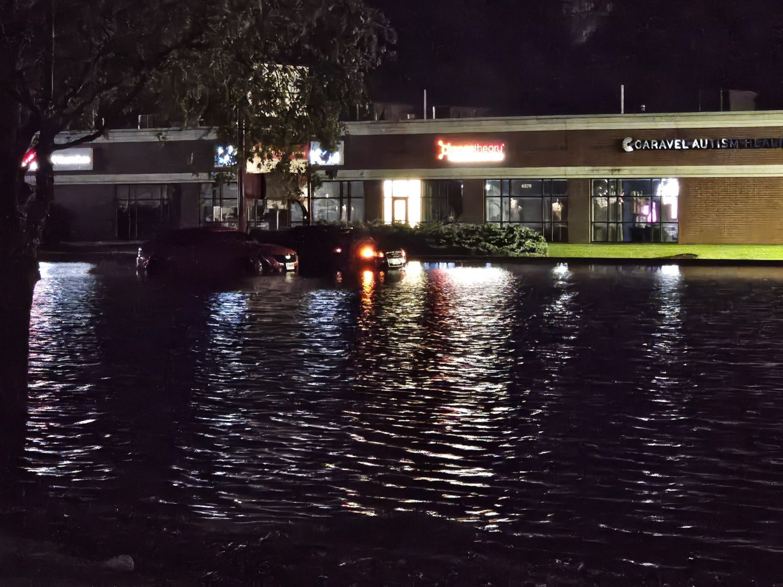
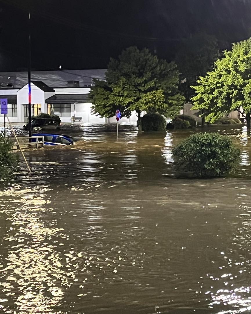
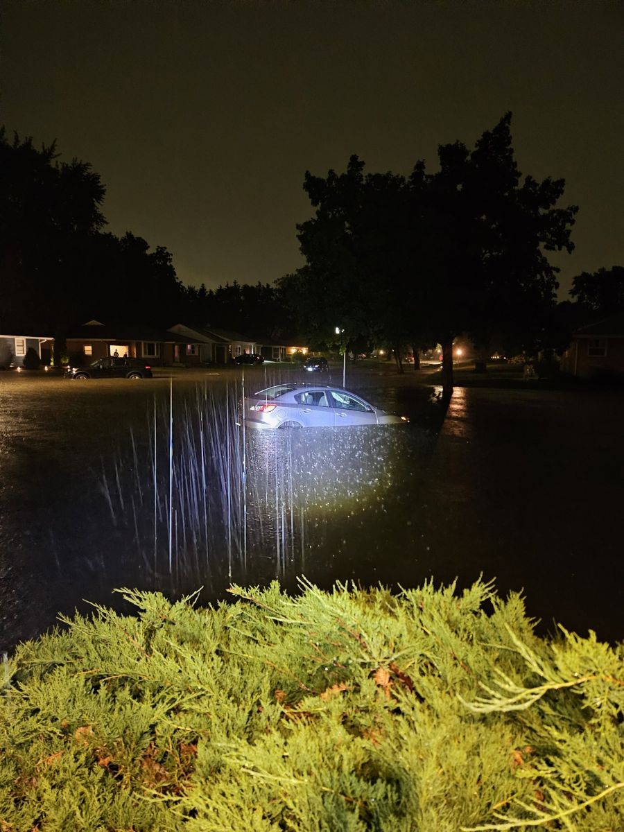
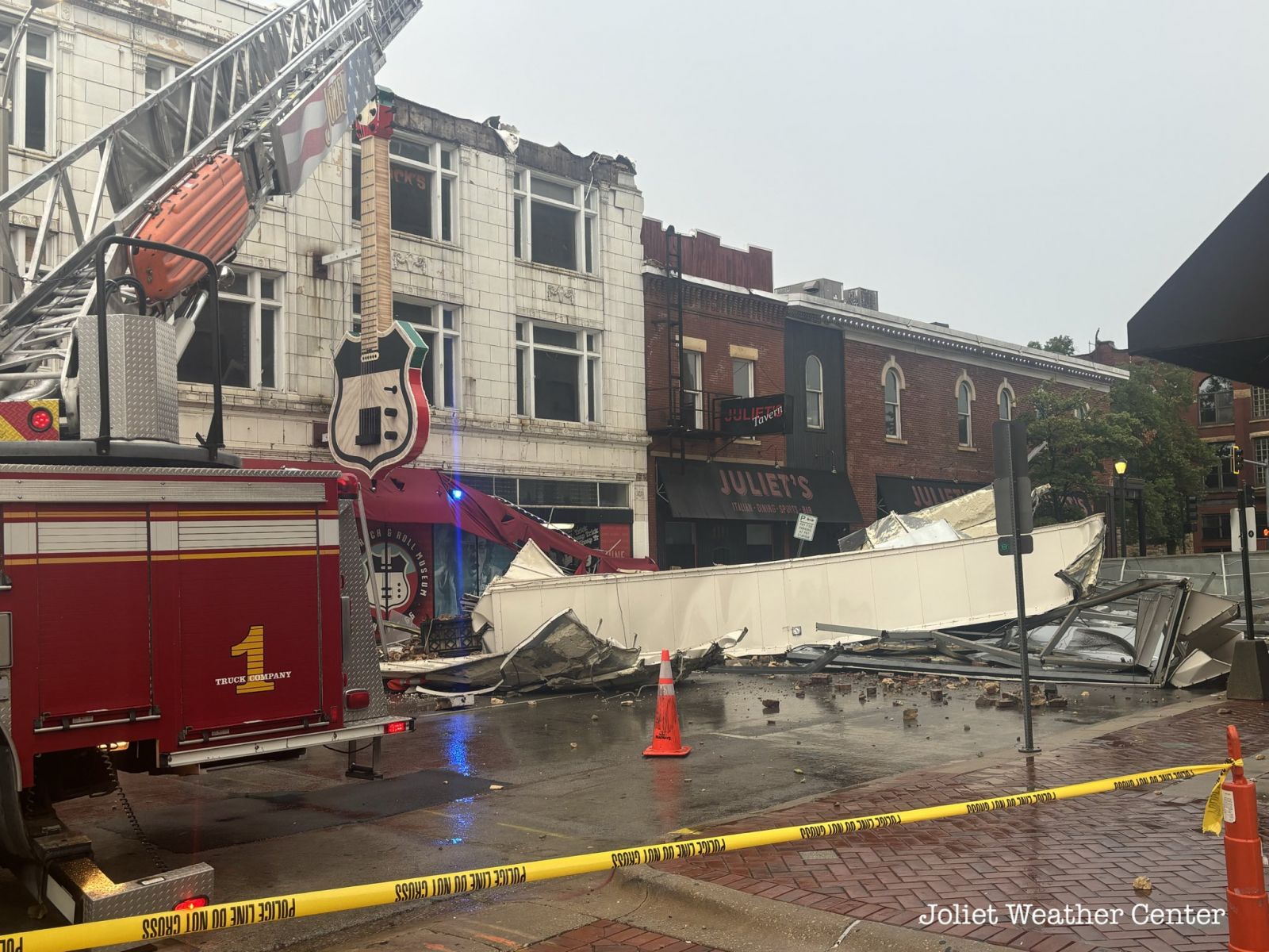
Flooding and Storm Reports
 |
 |
|
| Flash flooding in Rockford. Photo courtesy of the Rockford Fire Department. | Flash flooding in Rockford. Photo courtesy of Joey Marino (WTVO/WQRF). | Flash flooding in Rockford. Photo courtesy of Joey Marino (WTVO/WQRF). |
.jpg) |
 |
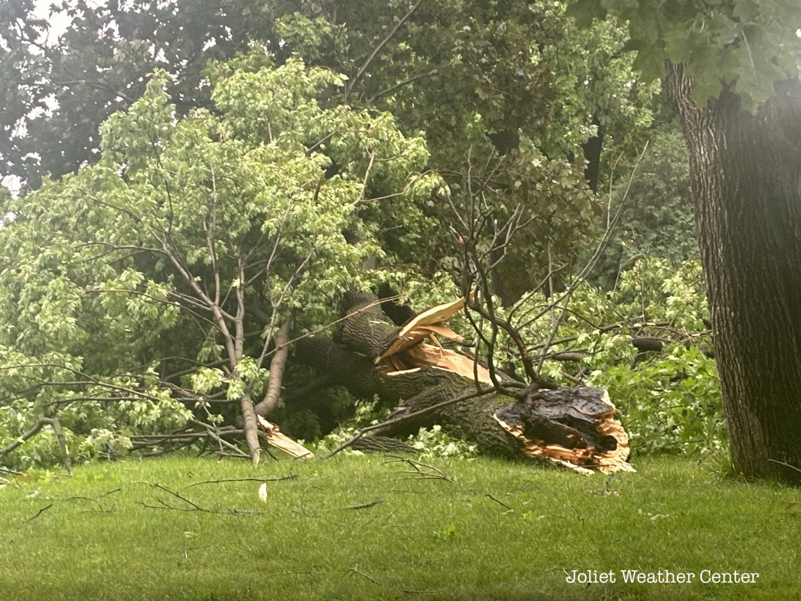 |
| Flash flooding in Rockford. Photo courtesy of Cam Huckabee. | Wind damage in downtown Joliet. Photo courtesy of the Joliet Weather Center. | Wind damage in Joliet. Photo courtesy of the Joliet Weather Center. |
Preliminary Local Storm Report...Summary
National Weather Service Chicago IL
340 PM CDT Sun Jul 14 2024
..TIME... ...EVENT... ...CITY LOCATION... ...LAT.LON...
..DATE... ....MAG.... ..COUNTY LOCATION..ST.. ...SOURCE....
..REMARKS..
1025 PM Hail Belvidere 42.26N 88.84W
07/13/2024 E0.75 Inch Boone IL Trained Spotter
Pea to penny size hail.
1039 PM Tstm Wnd Dmg 1 SE Rockford 42.26N 89.09W
07/13/2024 Winnebago IL Public
Tree downed onto roadway at Kishwaukee
Street and 3rd Avenue. Time estimated from
radar.
1047 PM Flood 1 NW Belvidere 42.27N 88.85W
07/13/2024 Boone IL Public
Report from mPING: Street/road flooding.
1125 PM Flash Flood 3 ESE Rockford 42.25N 89.03W
07/13/2024 Winnebago IL Fire Dept/Rescue
Water rescue near Eastmoreland Avenue and
Broadway in Rockford due to flash flooding.
1130 PM Rain Loves Park 42.31N 89.06W
07/13/2024 M4.00 Inch Winnebago IL Trained Spotter
Trained spotter reports 4 inches of rain in
one hour from approximately 1030 PM to 1130
PM.
1132 PM Flash Flood 1 NNE Rockford 42.29N 89.09W
07/13/2024 Winnebago IL Public
Water rescue near Auburn Street and and
Huffman Boulevard in Rockford due to flash
flooding.
1133 PM Flood 2 SSW Sleepy Hollow 42.06N 88.33W
07/13/2024 Kane IL Public
Multiple public reports of street flooding
in and near Elgin.
1136 PM Flash Flood 2 SE Rockford 42.25N 89.06W
07/13/2024 Winnebago IL Fire Dept/Rescue
Water rescue reported at Broadway and
Woodruff Ave.
1140 PM Flash Flood 2 ESE Rockford 42.26N 89.06W
07/13/2024 Winnebago IL Fire Dept/Rescue
Multiple vehicles stuck in floodwaters along
Charles Street near Rockford Avenue in
Rockford.
1145 PM Flash Flood 1 N Rockford 42.28N 89.10W
07/13/2024 Winnebago IL Fire Dept/Rescue
Possible flooding of residence near Whitman
Street and Rockton Avenue in Rockford.
1145 PM Flash Flood 2 ESE Rockford 42.26N 89.05W
07/13/2024 Winnebago IL Fire Dept/Rescue
Water rescue near Charles Street and 22nd
Street in Rockford due to flash flooding.
1149 PM Flash Flood 4 SE Rockford 42.24N 89.04W
07/13/2024 Winnebago IL Fire Dept/Rescue
Water rescue reported at Green Dale Drive
and Ashbrook Drive.
1149 PM Flash Flood 2 S Loves Park 42.29N 89.06W
07/13/2024 Winnebago IL Fire Dept/Rescue
Water rescue reported at Spring Creek Road
and North 2nd Street.
1155 PM Flash Flood 2 S Rockford 42.24N 89.09W
07/13/2024 Winnebago IL Public
Public report of street flooding in south
Rockford. Relayed via mping.
1200 AM Flood Villa Park 41.89N 87.98W
07/14/2024 DuPage IL Emergency Mngr
Street flooding up to 6 inches depth in
Villa Park.
1205 AM Flash Flood 1 WNW Cherry Valley 42.24N 88.98W
07/14/2024 Winnebago IL Public
Photo shared to social media shows water
flowing over Charles Street at Perryville
Road between Cherry Valley and Rockford due
to flooding from unnamed creek.
1206 AM Rain 1 W Cherry Valley 42.24N 88.98W
07/14/2024 M4.06 Inch Winnebago IL Trained Spotter
Trained spotter reports 4.06 inches of rain
so far west of Cherry Valley.
1207 AM Flash Flood 3 W Cherry Valley 42.24N 89.02W
07/14/2024 Winnebago IL Public
Drainage ditch near Harrison Avenue and
Alpine Road overlfowing in southeast
Rockford. Public report of 5 inches of rain
so far, with rainfall began about 1035 PM.
1213 AM Flash Flood 1 W Loves Park 42.32N 89.08W
07/14/2024 Winnebago IL Fire Dept/Rescue
Water rescue near Riverside Boulevard and
Latham Street due to flash flooding in
Rockford.
1230 AM Flash Flood 3 WNW Cherry Valley 42.26N 89.01W
07/14/2024 Winnebago IL Public
Public report of flooded residences near
Javelin Drive and Woodridge Driive in
Rockford. Also damage to nearby parking lot
pavement. Time estimated by radar and nearby
reports.
1230 AM Flash Flood 3 SSE Loves Park 42.28N 89.04W
07/14/2024 Winnebago IL Fire Dept/Rescue
Water rescue near Chelsea Avenue and Arden
Court in Rockford due to flash flooding.
1233 AM Flash Flood 2 S Rockford 42.24N 89.09W
07/14/2024 Winnebago IL Fire Dept/Rescue
Kishwaukee Street impassable at 23rd Avenue
due to flood waters.
1240 AM Flash Flood 1 ENE Elmhurst 41.91N 87.92W
07/14/2024 DuPage IL Public
Report on social media of North Avenue
flooded with several feet of water near
I-290.
1240 AM Flood 1 SW Chicago Loop 41.87N 87.64W
07/14/2024 Cook IL Public
Report on social media of water covering
multiple lanes of I-90 near Roosevelt Road
in Chicago.
1240 AM Flash Flood 2 ESE Rockford 42.26N 89.06W
07/14/2024 Winnebago IL Public
Corrects location of previous flash flood
report from 2 NNW Cherry Valley. Multiple
public reports of several cars and an
ambulance stuck in flood waters near Sams
Pizza on Charles Street.
1245 AM Flood 1 S South Lawndale - Ch 41.83N 87.72W
07/14/2024 Cook IL Public
Standing water on at least some lanes of
I-55 near Pulaski Road.
1254 AM Rain 3 ENE Rockford Airport 42.22N 89.04W
07/14/2024 M4.73 Inch Winnebago IL Public
Privatge weather station KILCHERR15 reported
4.73 inches of rain so far since 10 PM.
1255 AM Flash Flood 2 E Rockford 42.27N 89.06W
07/14/2024 Winnebago IL Public
Video showing several inches of water on
State Street just west of Rockford Avenue.
0100 AM Flash Flood 1 ESE Rockford 42.27N 89.08W
07/14/2024 Winnebago IL Fire Dept/Rescue
Water entering a few structures near
downtown Rockford including along Benton
Street and State Street.
0100 AM Flash Flood 2 ESE Rockford 42.26N 89.05W
07/14/2024 Winnebago IL Public
A video shared via social media shows a car
submerged in floodwater in the Schnucks
parking lot off of Charles St.
0105 AM Flash Flood 3 NW Cherry Valley 42.27N 88.99W
07/14/2024 Winnebago IL Fire Dept/Rescue
Water rescue near State Street and Trainer
Road in Rockford due to flash flooding.
0106 AM Rain 3 WNW Cherry Valley 42.25N 89.02W
07/14/2024 M5.03 Inch Winnebago IL Public
Private weather station KILROCKF122 reported
5.03 inches of rain so far since 10 PM.
0111 AM Tstm Wnd Dmg 3 NNE DeKalb 41.97N 88.74W
07/14/2024 De Kalb IL Trained Spotter
Reasonably healthy 12 inch diameter tree
downed just south of 1st Street and Bethany
Road.
0111 AM Flash Flood 3 E Rockford 42.26N 89.04W
07/14/2024 Winnebago IL Fire Dept/Rescue
Water rescue reported at Don Carter Lanes on
State Street.
0115 AM Flood 1 NNW Greater Grand Cro 41.77N 87.63W
07/14/2024 Cook IL Public
Relayed via social media, the left express
lane of I-90/94 was flooded near 67th St.
0119 AM Flash Flood 2 NW Rockford 42.29N 89.12W
07/14/2024 Winnebago IL Fire Dept/Rescue
Water rescue near Auburn Street and Central
Avenue in Rockford due to flash flooding.
0122 AM Flash Flood 2 NNW Rockford 42.30N 89.11W
07/14/2024 Winnebago IL Public
Water rescue on the 3400 block of Garfield
Dr due to flash flooding.
0124 AM Flash Flood 4 WSW Cherry Valley 42.22N 89.03W
07/14/2024 Winnebago IL Fire Dept/Rescue
Water rescue reported at Sandy Hollow Road
and Alpine Road.
0125 AM Flood 1 NW Pullman - Chicago 41.71N 87.61W
07/14/2024 Cook IL Public
Report via social media of flooding across
all lanes of I-94 at Cottage Grove in
Chicago.
0134 AM Rain 3 WNW Rockford 42.28N 89.15W
07/14/2024 M6.15 Inch Winnebago IL Public
Private weather station KILROCKF160 reported
6.15 inches rain so far since 10 PM.
0137 AM Flash Flood 2 ESE Rockford 42.26N 89.06W
07/14/2024 Winnebago IL Fire Dept/Rescue
Several water rescues reported on the 600
block of St. Louis Avenue.
0140 AM Flash Flood 2 NNW Rockford 42.29N 89.11W
07/14/2024 Winnebago IL Fire Dept/Rescue
Numerous homes surrounded by water due to
flash flooding along Northwest Drainage
Ditch in northwest Rockford. Water rescues
via boat ongoing.
0143 AM Flash Flood 2 SE Rockford 42.26N 89.07W
07/14/2024 Winnebago IL Fire Dept/Rescue
Flood waters up to houses doorways on the
1000 block of 14th Street. Residents being
evacuated.
0145 AM Rain 1 W Cherry Valley 42.24N 88.98W
07/14/2024 M5.39 Inch Winnebago IL Trained Spotter
Rainfall total observed by trained spotter
between 10:12 PM and 1:45 AM.
0145 AM Flash Flood 2 ESE Rockford 42.26N 89.07W
07/14/2024 Winnebago IL Fire Dept/Rescue
Multiple homes surrounded by water from
flash flooding of Keith Creek between 11th
Street and 18th Street in Rockford.
0312 AM Rain 2 NW Cherry Valley 42.26N 88.99W
07/14/2024 M5.50 Inch Winnebago IL Public
Private weather station KILROCKF188 reported
5.5 inches of rain.
0316 AM Rain 3 SSE Loves Park 42.28N 89.04W
07/14/2024 M5.62 Inch Winnebago IL Public
Private weather station KILROCKF217 reported
5.62 inches of rainfall.
0320 AM Rain 2 WSW Cherry Valley 42.23N 89.00W
07/14/2024 M5.35 Inch Winnebago IL Public
Private weather station KILROCKF201 reported
5.35 inches of rainfall.
0329 AM Marine Tstm Wind 2 NE Navy Pier 41.92N 87.57W
07/14/2024 M51 MPH LMZ741 IL C-Man Station
0630 AM Rain 3 WSW Rockford 42.25N 89.15W
07/14/2024 M3.81 Inch Winnebago IL Cocorahs
Cocorahs station IL-WN-40 Rockford 3 WSW.
0635 AM Tstm Wnd Dmg 1 SW Oregon 42.00N 89.35W
07/14/2024 Ogle IL Trained Spotter
Trees downed onto power lines along Pines
Road west of Oregon.
0700 AM Rain 2 WNW Loves Park 42.32N 89.09W
07/14/2024 M4.87 Inch Winnebago IL Cocorahs
Cocorahs station IL-WN-48 4 NNW Rockford.
0716 AM Tstm Wnd Gst 6 SE Ashton 41.80N 89.16W
07/14/2024 M41 MPH Lee IL Public
Personal weather station recorded a gust of
41 mph.
0727 AM Tstm Wnd Gst 2 SE Compton 41.68N 89.06W
07/14/2024 M43 MPH Lee IL Public
Personal weather station recorded a gust of
43 mph.
0730 AM Flood 3 NNE Fairdale 42.14N 88.90W
07/14/2024 De Kalb IL Public
Photo shared on social media shows roadway
flooding due to Trimble Run near Irene Road
and McNeal Road northwest of Kirkland.
Relayed by broadcast media.
0742 AM Tstm Wnd Gst 3 NNE Leland 41.66N 88.78W
07/14/2024 M45 MPH De Kalb IL Public
Personal weather station recorded a gust of
45 mph.
0745 AM Tstm Wnd Gst 3 WSW Leland 41.59N 88.85W
07/14/2024 M46 MPH La Salle IL Public
Personal weather station recorded a wind
gust of 46 mph.
0756 AM Tstm Wnd Gst Leland 41.61N 88.80W
07/14/2024 M42 MPH La Salle IL Public
Personal weather station record a wind gust
of 42 mph.
0811 AM Tstm Wnd Gst 3 ENE Norway 41.48N 88.62W
07/14/2024 M45 MPH La Salle IL Public
Personal weather station recorded a wind
gust of 45 mph.
0813 AM Tstm Wnd Gst 3 NE Marseilles 41.36N 88.66W
07/14/2024 M41 MPH La Salle IL Public
Personal weather station recorded a wind
gust of 41 mph.
0829 AM Tstm Wnd Gst 1 ENE Minooka 41.46N 88.25W
07/14/2024 M42 MPH Will IL Public
Personal weather station recorded a wind
gust of 42 mph.
0832 AM Tstm Wnd Gst 1 WSW Minooka 41.45N 88.28W
07/14/2024 M43 MPH Grundy IL Public
Personal weather station recorded a wind
gust of 43 mph.
0832 AM Tstm Wnd Gst 2 SW Minooka 41.43N 88.29W
07/14/2024 M40 MPH Grundy IL Public
Personal weather station recorded a wind
gust of 40 mph.
0839 AM Tstm Wnd Dmg 1 W Joliet 41.53N 88.10W
07/14/2024 Will IL Trained Spotter
Multiple reports of tree damage across the
west side of Joliet, including snapped trees
and downed limbs. Time estimated from radar.
0840 AM Tstm Wnd Gst 2 N Rockdale 41.53N 88.12W
07/14/2024 E60 MPH Will IL Trained Spotter
Several branches down and lost power.
0843 AM Tstm Wnd Dmg Joliet 41.53N 88.08W
07/14/2024 Will IL Emergency Mngr
Updates previous tstm wnd dmg report from
Joliet. Photos relayed by EM show about half
of the roof blown off the Illinois Rock and
Roll Museum. The roof and roofing material
was blown to the southeast. Time estimated
based on radar.
0853 AM Tstm Wnd Gst 2 NNW Manhattan 41.45N 88.00W
07/14/2024 M43 MPH Will IL Public
Personal weather station recorded a wind
gust of 42 mph.
0855 AM Tstm Wnd Gst 3 SSE Symerton 41.29N 88.04W
07/14/2024 M40 MPH Will IL Public
Personal weather station recorded a wind
gust of 40 mph.
0900 AM Rain 3 WNW Rockford 42.28N 89.15W
07/14/2024 M6.30 Inch Winnebago IL Mesonet
Event total from personal weather station
KILROCKF47.
0900 AM Rain 2 ENE Rockford 42.28N 89.06W
07/14/2024 M6.24 Inch Winnebago IL Mesonet
Event total from personal weather station
KILROCKF128.
0900 AM Rain 3 WNW Cherry Valley 42.26N 89.01W
07/14/2024 M5.74 Inch Winnebago IL Amateur Radio
0900 AM Rain 3 SSE Loves Park 42.28N 89.04W
07/14/2024 M5.69 Inch Winnebago IL Mesonet
Event total from personal weather station
KILROCKF217.
0900 AM Rain 2 NW Cherry Valley 42.26N 88.99W
07/14/2024 M5.66 Inch Winnebago IL Mesonet
Event total from personal weather station
KILROCKF188.
0900 AM Rain 2 WSW Cherry Valley 42.23N 89.00W
07/14/2024 M5.54 Inch Winnebago IL Mesonet
Event total from personal weather station
KILROCKF201.
0900 AM Rain 2 WNW Cherry Valley 42.25N 89.00W
07/14/2024 M5.31 Inch Winnebago IL Mesonet
Event total from personal weather station
KILROCKF215.
0900 AM Rain 3 WNW Cherry Valley 42.25N 89.02W
07/14/2024 M5.30 Inch Winnebago IL Mesonet
Event total from personal weather station
KILROCKF122.
0900 AM Rain 3 ENE Winnebago 42.28N 89.18W
07/14/2024 M4.95 Inch Winnebago IL Mesonet
Event total from personal weather station
KILWINNE48.
0900 AM Rain 3 ENE Rockford Airport 42.22N 89.04W
07/14/2024 M4.85 Inch Winnebago IL Mesonet
Event total from personal weather station
KILCHERR15.
0900 AM Rain 4 N Herbert 42.21N 88.78W
07/14/2024 M4.80 Inch Boone IL Mesonet
Event total from personal weather station
KILBELVI57.
0900 AM Rain 2 WNW Loves Park 42.32N 89.10W
07/14/2024 M4.48 Inch Winnebago IL Mesonet
Event total from personal weather station
KILROCKF141.
0900 AM Rain 3 WNW Loves Park 42.33N 89.11W
07/14/2024 M4.45 Inch Winnebago IL Mesonet
Event total from personal weather station
KILROCKF164.
0900 AM Rain 3 E Loves Park 42.31N 89.01W
07/14/2024 M4.22 Inch Winnebago IL Mesonet
Event total from personal weather station
KILROCKF125.
0900 AM Rain 5 SSW Marengo 42.19N 88.64W
07/14/2024 M4.21 Inch McHenry IL Mesonet
Event total from personal weather station
KILMAREN25.
0900 AM Rain 3 SW Herbert 42.13N 88.82W
07/14/2024 M4.13 Inch De Kalb IL Mesonet
Event total from personal weather station
KILKINGS11.
0925 AM Tstm Wnd Gst Grant Park 41.24N 87.65W
07/14/2024 M49 MPH Kankakee IL Public
Personal weather station recorded a wind
gust of 49 mph. Site ID: KILGRANT12.
0925 AM Tstm Wnd Dmg 1 E Grant Park 41.24N 87.63W
07/14/2024 Kankakee IL Trained Spotter
Trees and large tree limbs downed in and
near Grant Park. Patches of corn also
flattened east of Grant Park.
0939 AM Tstm Wnd Gst 1 NW Lowell 41.30N 87.44W
07/14/2024 M60 MPH Lake IN Trained Spotter
Measured on a personal weather station.
&&
$$
 |
Media use of NWS Web News Stories is encouraged! Please acknowledge the NWS as the source of any news information accessed from this site. Additional recaps can be found on the NWS Chicago Past Events Page |
|