Widespread life-threatening flash and urban flooding continues in south-central Texas, with considerable flooding impacts possible across central Texas. Wildfire smoke is impacting air quality across much of the Great Lakes region into southern New England and the Mid-Atlantic. Monsoonal thunderstorms may produce isolated to scattered flash flooding across the Southwest into the Great Basin. Read More >
|
|
Overview
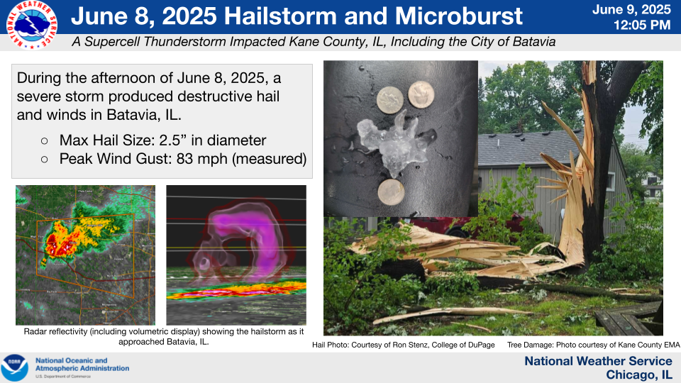
A thunderstorm developed near Rochelle, IL during the afternoon of Sunday, June 8th, and gradually intensified as it tracked eastward along the I-88 corridor into the Chicago metro. With time, the storm developed a rotating updraft, which allowed it to become a supercell thunderstorm.
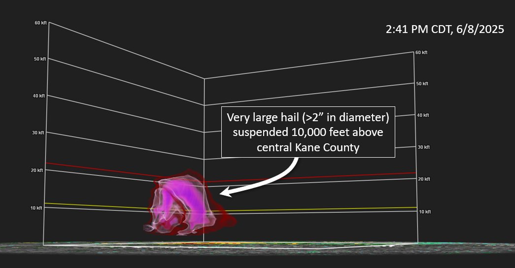
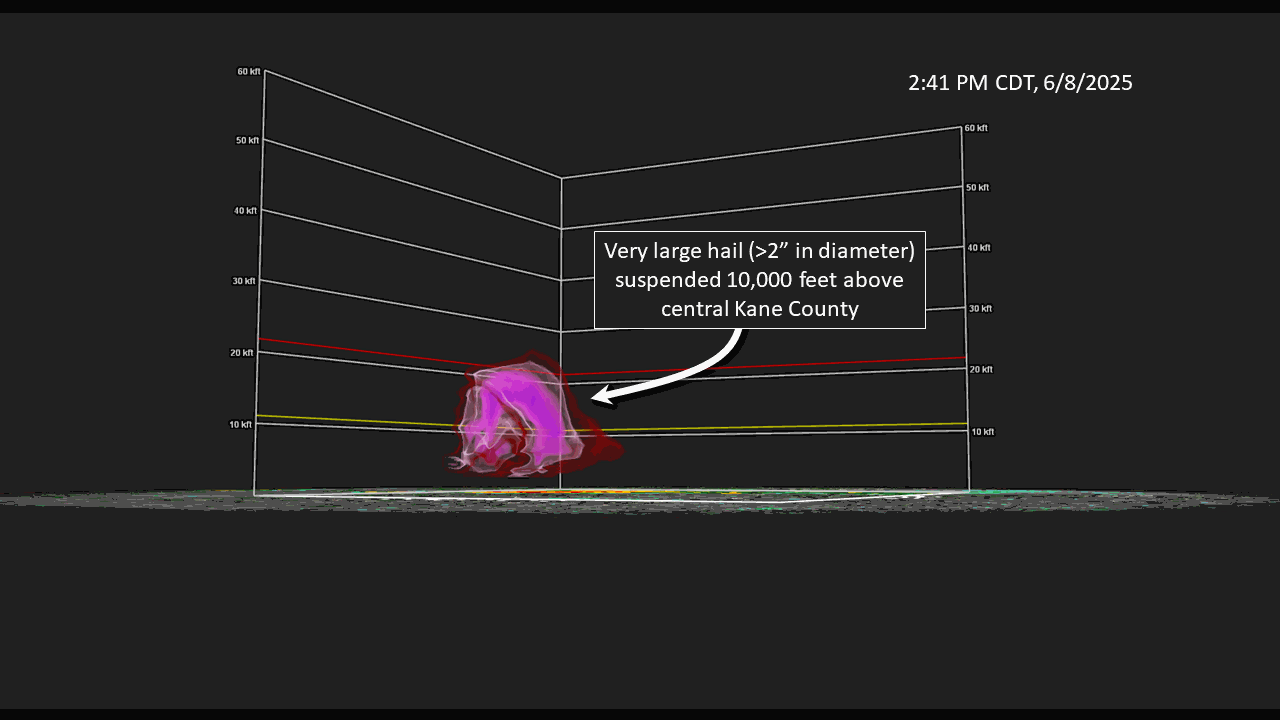
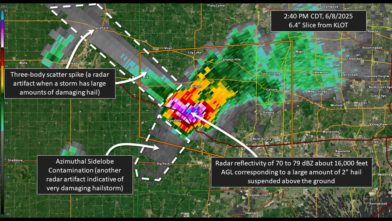
As the supercell moved across Kane County, it developed a massive "core", or a mass of heavy rain and hail, about 10,000 to 15,000 feet above the ground.
|
|
As the core grew larger, it became too heavy to stay suspended in the storm, so it came crashing to the ground. Unfortunately, this ended up occurring directly over Batavia, where hail up to tennis ball size was observed and 80-85 mph winds produced a relatively narrow corridor of notable tree and power line damage across the city. This process of when a mass of air suspended within a thunderstorm rapidly comes crashing down to ground level, producing a strong burst of wind over a small area is known as a microburst.
|
|
A Severe Thunderstorm Warning was issued for Kane County (including Batavia) several minutes prior to the core of the storm crashing down. Below are a few key features that we saw on radar after we issued the warning, giving us confidence that the storm was only becoming stronger and about to produce very large hail and damaging winds.
|
|
Storm Reports
|
Preliminary Storm Report Map |
..TIME...   ...EVENT...      ...CITY LOCATION...     ...LAT.LON...
..DATE...   ....MAG....      ..COUNTY LOCATION..ST.. ...SOURCE....
            ..REMARKS..

0215 PM     Tstm Wnd Dmg     2 WSW Cortland          41.91N 88.71W
06/08/2025                   De Kalb            IL   Emergency Mngr

            Power poles downed onto Webster Road north
            of I-88 southeast of DeKalb. Time estimated
            from radar.

0215 PM     Tstm Wnd Dmg     2 ESE DeKalb            41.92N 88.72W
06/08/2025                   De Kalb            IL   Trained Spotter

            Photo shared of 5 utility poles blown down
            near Peace Road and Route 38. Time
            estimated.

0236 PM     Hail             3 E Maple Park          41.89N 88.54W
06/08/2025  E0.50 Inch       Kane               IL   Public

            Multiple half inch hail reports between
            Maple Park and Elburn.

0243 PM     Hail             1 SE Elburn             41.87N 88.46W
06/08/2025  E1.00 Inch       Kane               IL   Public

            Multiple public reports of quarter size hail
            in Elburn. Time estimated from radar.

0245 PM     Tstm Wnd Dmg     4 SE Elburn             41.84N 88.43W
06/08/2025                   Kane               IL   Public

            Photos shared of trees and large tree limbs
            downed along Main Street west of Bunker
            Road. Time estimated from radar.

0245 PM     Hail             3 E Maple Park          41.91N 88.54W
06/08/2025  M0.50 Inch       Kane               IL   Public

            Half inch diameter hail halfway between
            Maple Park and Elburn.

0248 PM     Hail             3 WNW Batavia           41.86N 88.38W
06/08/2025  M1.75 Inch       Kane               IL   Public

            Corrects location of previous hail report
            from 1 ESE Elburn. Hail ranged from quarter
            to golf ball size on the southwest side of
            Geneva.
0254 PM     Hail             2 WNW Batavia           41.86N 88.35W
06/08/2025  M2.00 Inch       Kane               IL   Trained Spotter

            2 inch diameter hail reported near Fabyan
            Parkway and Branson Drive in Batavia.

0254 PM     Hail             4 W Batavia             41.85N 88.38W
06/08/2025  M1.50 Inch       Kane               IL   Amateur Radio

            Photo shared of a hailstone just under 1.5
            inches in diameter.

0256 PM     Hail             1 W Batavia             41.85N 88.34W
06/08/2025  E1.00 Inch       Kane               IL   Public

            Quarter size hail reported near Randall Road
            and McKee Street in Batavia.

0256 PM     Hail             1 SSW Batavia           41.84N 88.32W
06/08/2025  M2.30 Inch       Kane               IL   Trained Spotter

            Trained spotter shared photos of multiple
            elongated hailstones measuring greater than
            2 inches in diameter in Batavia.

0256 PM     Hail             1 W Batavia             41.86N 88.34W
06/08/2025  E2.50 Inch       Kane               IL   Public

            mPING report.

0256 PM     Hail             3 W Batavia             41.85N 88.37W
06/08/2025  E1.75 Inch       Kane               IL   Emergency Mngr

            Golf ball size hail reported at Main Street
            and Nelson Lake Road in Batavia.

0256 PM     Hail             1 W Batavia             41.85N 88.34W
06/08/2025  E1.00 Inch       Kane               IL   Emergency Mngr

            Quarter size hail reported at Randall Road
            and Main Street in Batavia.

0256 PM     Hail             1 NW Batavia            41.86N 88.32W
06/08/2025  E1.00 Inch       Kane               IL   Public

            mPING report.

0257 PM     Hail             Batavia                 41.85N 88.31W
06/08/2025  E2.50 Inch       Kane               IL   Trained Spotter

            Meteorology professor reported hail up to
            2.5 inches in diameter in Batavia. Average
            hailstone diameter was approximately 2
            inches.

0257 PM     Hail             1 SSW Batavia           41.84N 88.32W
06/08/2025  E2.50 Inch       Kane               IL   Public

            Photo shared on social media of
            approximately 2 to 2.5 inch diameter hail in
            Batavia. A video shared under the same post
            showed wind-driven hail destroying a window
            screen.

0257 PM     Hail             2 W Batavia             41.84N 88.34W
06/08/2025  M2.00 Inch       Kane               IL   Public

            mPING report.

0257 PM     Hail             Batavia                 41.85N 88.31W
06/08/2025  E1.00 Inch       Kane               IL   Emergency Mngr

            Quarter size hail reported at First Street
            and Lincoln Street in Batavia.

0257 PM     Hail             3 NW North Aurora       41.83N 88.36W
06/08/2025  E0.75 Inch       Kane               IL   Public

            mPING report.

0258 PM     Tstm Wnd Dmg     1 SSW Batavia           41.84N 88.32W
06/08/2025                   Kane               IL   Emergency Mngr

            Large tree snapped at Harrison Street and
            Carlisle Road in Batavia.

0258 PM     Hail             1 WSW Batavia           41.85N 88.33W
06/08/2025  E2.00 Inch       Kane               IL   Public

            Photo shared on social media showing
            hailstones roughly twice the size of a
            quarter along Main Street east of Randall
            Road in Batavia.

0258 PM     Tstm Wnd Dmg     Batavia                 41.85N 88.31W
06/08/2025                   Kane               IL   Emergency Mngr

            Power pole snapped along Wilson Street near
            River Street in Batavia.

0258 PM     Tstm Wnd Dmg     Batavia                 41.85N 88.31W
06/08/2025                   Kane               IL   Emergency Mngr

            Multiple trees downed in Batavia.

0258 PM     Tstm Wnd Gst     1 SSW Batavia           41.83N 88.33W
06/08/2025  M83 MPH          Kane               IL   CO-OP Observer

            Corrects location of previous tstm wnd gst
            report from Batavia. COOP observer measured
            83 mph gust on personal weather station in
            Batavia. Large tree branches were downed.

0258 PM     Hail             1 SSW Batavia           41.83N 88.33W
06/08/2025  E1.75 Inch       Kane               IL   CO-OP Observer

            Corrects location of previous hail report
            from Batavia. COOP observer in Batavia
            reported wind-driven hail with the largest
            hailstones approximately golf ball sized.

0301 PM     Hail             2 NE North Aurora       41.82N 88.31W
06/08/2025  U0.50 Inch       Kane               IL   Public

            mPING report.

0312 PM     Hail             West Chicago            41.88N 88.21W
06/08/2025  E0.50 Inch       DuPage             IL   Public

            mPING report.

0312 PM     Hail             1 WNW Warrenville       41.82N 88.20W
06/08/2025  E0.88 Inch       DuPage             IL   Emergency Mngr


0316 PM     Hail             3 E Warrenville         41.83N 88.13W
06/08/2025  E0.75 Inch       DuPage             IL   Public

            mPING report.

0323 PM     Tstm Wnd Dmg     1 NW Downers Grove      41.81N 88.03W
06/08/2025                   DuPage             IL   Public

            Large tree branches downed at multiple
            residences near Lacey Road and Ogden Avenue
            in Downers Grove.

0350 PM     Tstm Wnd Gst     Burbank                 41.74N 87.77W
06/08/2025  E50 MPH          Cook               IL   Public

            Estimated wind gusts 45 to 50 mph.

0430 PM     Marine Tstm Wind 3 NE Navy Pier          41.92N 87.57W
06/08/2025  M41 MPH          LMZ741             IL   C-Man Station

            Measured gust to 36 knots at the Harrison
            Dever Crib.

0530 PM     Tstm Wnd Gst     Crown Point             41.42N 87.37W
06/08/2025  E50 MPH          Lake               IN   Public

            Estimated wind gusts to 50 mph.

0540 PM     Tstm Wnd Gst     Lakes of the Four Seaso 41.41N 87.22W
06/08/2025  E50 MPH          Lake               IN   Amateur Radio


&&

$$
|
Rainfall
CoCoRaHS Precipitation Summary National Weather Service Chicago IL 908 AM CDT Mon Jun 9 2025 CoCoRaHS Precipitation Reports for the previous 24 hours ending around 7 AM Local Time These reports are considered supplemental and unofficial .B LOT 0609 C DH07/PP/SF/SD/SW : : :Illinois CoCoRaHS Precipitation Reports : : Snow Snow Water : Pcpn Fall Depth Equiv : IL-KN-135 : Batavia 0.8 W : 1.19 / MM / MM / MM IL-KN-23 : Batavia 1.5 WNW : 1.16 / MM / MM / MM IL-KN-22 : Geneva 1.0 SSW : 0.94 / 0.0 / 0.0 / MM IL-CK-12 : Bridgeview 1.3 NNW : 0.89 / MM / MM / MM IL-DK-36 : De Kalb 3.5 WSW : 0.76 / MM / MM / MM IL-DK-28 : De Kalb 0.7 SW : 0.65 / 0.0 / 0.0 / MM IL-KN-121 : Geneva 1.3 NW : 0.65 / 0.0 / 0.0 / 0.00 IL-DP-161 : Wheaton 1.2 NNW : 0.61 / MM / MM / MM IL-DK-05 : Cortland 0.3 SSW : 0.58 / MM / MM / MM IL-DP-191 : Winfield 0.7 NE : 0.56 / MM / MM / MM IL-KN-119 : Maple Park 3.1 SE : 0.56 / MM / MM / MM IL-DK-09 : De Kalb 3.2 WNW : 0.52 / MM / MM / MM IL-KN-133 : Geneva 0.9 E : 0.52 / MM / MM / MM IL-LV-23 : Fairbury 4.7 SSE : 0.51 / MM / MM / MM IL-IR-30 : Clifton 6.2 ENE : 0.50 / MM / MM / MM IL-MCH-108 : Spring Grove 1.2 ESE : 0.48 / MM / MM / MM IL-DP-132 : Wheaton 2.0 NNE : 0.44 / 0.0 / 0.0 / 0.00 IL-DK-38 : Cortland 0.3 E : 0.42 / MM / MM / MM IL-KN-150 : St. Charles 0.8 SSE : 0.41 / MM / MM / MM IL-WL-84 : Beecher 3.4 ENE : 0.41 / MM / MM / MM IL-LV-21 : Chatsworth 1.2 S : 0.40 / MM / MM / MM IL-CK-98 : La Grange Park 0.7 SSW : 0.38 / MM / MM / MM IL-CK-438 : Chicago 5.9 SW : 0.38 / MM / MM / MM IL-MCH-101 : Crystal Lake 1.9 SW : 0.38 / MM / MM / MM IL-LK-42 : Gurnee 1.6 W : 0.37 / MM / MM / MM IL-KN-64 : St. Charles 0.1 E : 0.35 / 0.0 / 0.0 / MM IL-DP-117 : Elmhurst 2.0 SE : 0.34 / MM / MM / MM IL-DP-173 : Lombard 1.2 N : 0.34 / MM / MM / MM IL-GY-10 : Minooka 0.3 NE : 0.33 / MM / MM / MM IL-MCH-83 : Crystal Lake 1.0 WSW : 0.33 / MM / MM / MM IL-WL-149 : Bult Field-Monee 4.9 SE : 0.32 / 0.0 / 0.0 / MM IL-DP-85 : Villa Park 1.0 NW : 0.31 / MM / MM / MM IL-MCH-87 : Marengo 0.7 NNE : 0.31 / MM / MM / MM IL-IR-14 : Watseka 6.9 WNW : 0.30 / MM / MM / MM IL-MCH-85 : Lake In The Hills 2.5 W : 0.30 / MM / MM / MM IL-KD-136 : Oswego 0.3 E : 0.29 / MM / MM / MM IL-MCH-94 : McHenry 2.4 E : 0.29 / MM / MM / MM IL-CK-148 : Oak Lawn 1.9 SE : 0.28 / MM / MM / MM IL-DP-163 : Lombard 1.2 E : 0.28 / MM / MM / MM IL-IR-26 : Buckley 4.0 ENE : 0.28 / MM / MM / MM IL-LK-81 : Lake Villa 2.3 WSW : 0.28 / MM / MM / MM IL-LK-112 : Lindenhurst 1.0 ENE : 0.28 / MM / MM / MM IL-WL-99 : Manhattan 1.9 SE : 0.28 / MM / MM / MM IL-MCH-107 : Crystal Lake 3.9 WNW : 0.27 / MM / MM / MM IL-WN-45 : Machesney Park 0.9 W : 0.27 / MM / MM / MM IL-KN-67 : St. Charles 6.0 NW : 0.26 / 0.0 / 0.0 / MM IL-IR-24 : Clifton 3.9 ESE : 0.26 / MM / MM / MM IL-KK-45 : Kankakee 1.4 WSW : 0.26 / MM / MM / MM IL-KN-128 : Batavia 3.4 WSW : 0.26 / MM / MM / MM IL-KN-153 : South Elgin 3.1 WSW : 0.26 / MM / MM / MM IL-KD-127 : Oswego 1.7 WSW : 0.25 / 0.0 / 0.0 / MM IL-DP-192 : Lombard 1.7 NW : 0.25 / MM / MM / MM IL-LK-09 : Lake Villa 1.1 SSW : 0.24 / MM / MM / MM IL-WL-46 : Peotone 0.4 ENE : 0.24 / MM / MM / MM IL-CK-394 : Burr Ridge 0.5 SE : 0.23 / MM / MM / MM IL-KN-09 : Elgin 1.0 S : 0.22 / 0.0 / 0.0 / MM IL-CK-412 : Oak Park 1.1 N : 0.22 / MM / MM / MM IL-LK-87 : Lake Zurich 1.3 N : 0.22 / MM / MM / MM IL-WL-159 : New Lenox 2.1 S : 0.22 / MM / MM / MM IL-DP-178 : Villa Park 0.8 ESE : 0.21 / 0.0 / 0.0 / 0.00 IL-CK-152 : Chicago Ridge 0.2 WSW : 0.21 / MM / MM / MM IL-LK-13 : Lake Bluff 1.3 W : 0.21 / MM / MM / MM IL-LK-18 : Grayslake 0.7 WSW : 0.21 / MM / MM / MM IL-GY-40 : Channahon 3.3 WSW : 0.20 / MM / MM / MM IL-LK-124 : Volo 1.6 N : 0.20 / MM / MM / MM IL-MCH-95 : Cary 0.5 SSW : 0.20 / MM / MM / MM IL-WL-166 : Naperville 3.6 SE : 0.20 / MM / MM / MM IL-BN-14 : Capron 0.1 N : 0.19 / MM / MM / MM IL-LK-23 : Winthrop Harbor 0.2 SSE : 0.19 / MM / MM / MM IL-LV-27 : Flanagan 0.4 NNE : 0.19 / MM / MM / MM IL-WL-23 : Beecher 3.4 SSE : 0.19 / MM / MM / MM IL-CK-74 : Oak Park 1.3 NNE : 0.18 / 0.0 / MM / MM IL-MCH-103 : Harvard 4.4 NNE : 0.18 / 0.0 / 0.0 / 0.00 IL-CK-364 : Evergreen Park 0.4 WNW : 0.18 / MM / MM / MM IL-DP-150 : Bloomingdale 1.2 ESE : 0.18 / MM / MM / MM IL-WL-179 : New Lenox 2.8 SE : 0.18 / MM / MM / MM IL-CK-75 : Elk Grove Village 2.2 WSW : 0.17 / MM / MM / MM IL-CK-430 : Worth 0.3 S : 0.17 / MM / MM / MM IL-DK-42 : Sycamore 1.4 SE : 0.17 / MM / MM / MM IL-WL-63 : New Lenox 1.8 SE : 0.17 / MM / MM / MM IL-WL-165 : Frankfort 1.3 ESE : 0.17 / MM / MM / MM IL-LK-54 : Mundelein 0.5 NNE : 0.16 / MM / MM / MM IL-WL-147 : New Lenox 2.0 ESE : 0.16 / MM / MM / MM IL-WL-178 : Mokena 2.1 SW : 0.16 / MM / MM / MM IL-DP-174 : Bolingbrook 2.6 NE : 0.15 / MM / MM / MM IL-DP-198 : Woodridge 0.3 SW : 0.15 / MM / MM / MM IL-IR-25 : Milford 3.5 ENE : 0.15 / MM / MM / MM IL-MCH-43 : Algonquin 0.7 N : 0.14 / 0.0 / 0.0 / 0.00 IL-WL-92 : Naperville 4.0 SSW : 0.14 / MM / MM / MM IL-IR-29 : Donovan 5.8 SE : 0.13 / MM / MM / MM IL-LK-16 : Buffalo Grove 1.5 N : 0.13 / MM / MM / MM IL-KD-102 : Oswego 2.4 SSW : 0.12 / 0.0 / 0.0 / MM IL-CK-69 : Park Forest 0.8 NNE : 0.12 / MM / MM / MM IL-KD-109 : Yorkville 1.0 N : 0.12 / MM / MM / MM IL-MCH-33 : Woodstock 3.8 SW : 0.12 / MM / MM / MM IL-WN-50 : Rockton 3.1 SW : 0.12 / MM / MM / MM IL-CK-131 : Schaumburg 2.0 E : 0.11 / MM / MM / MM IL-CK-345 : Franklin Park 0.5 SSE : 0.11 / MM / MM / MM IL-GY-34 : Morris 4.5 NW : 0.11 / MM / MM / MM IL-KD-143 : Yorkville 3.1 N : 0.11 / MM / MM / MM IL-MCH-115 : McHenry 3.8 ENE : 0.11 / MM / MM / MM IL-KN-04 : Sugar Grove 0.7 NE : 0.10 / 0.0 / MM / MM IL-LK-74 : Mundelein 1.6 WNW : 0.10 / MM / MM / MM IL-LK-119 : Lake Zurich 1.4 W : 0.10 / MM / MM / MM IL-LK-128 : Lake Forest 2.0 WSW : 0.10 / MM / MM / MM IL-LS-74 : Earlville 2.5 SSW : 0.09 / MM / MM / MM IL-KK-39 : Herscher 3.3 E : 0.08 / 0.0 / 0.0 / MM IL-CK-285 : Harwood Heights 0.4 NNE : 0.08 / MM / MM / MM IL-CK-390 : Alsip 0.9 E : 0.08 / MM / MM / MM IL-KK-48 : Bradley 0.7 SW : 0.08 / MM / MM / MM IL-DP-79 : Burr Ridge 1.9 SW : 0.07 / 0.0 / 0.0 / MM IL-CK-229 : Flossmoor 1.2 ESE : 0.07 / MM / MM / MM IL-CK-384 : Chicago 3.6 NNW : 0.07 / MM / MM / MM IL-IR-22 : Chebanse 1.6 SW : 0.07 / MM / MM / MM IL-KK-28 : Chebanse 0.4 NNE : 0.07 / MM / MM / MM IL-KN-138 : Aurora 3.2 WNW : 0.07 / MM / MM / MM IL-KN-140 : Algonquin 1.3 SE : 0.07 / MM / MM / MM IL-WL-97 : New Lenox 3.3 E : 0.06 / 0.0 / 0.0 / 0.00 IL-CK-278 : Hoffman Estates 1.6 SE : 0.05 / MM / MM / MM IL-FD-09 : Gibson City 3.0 WNW : 0.05 / MM / MM / MM IL-KD-110 : Yorkville 0.9 SSW : 0.05 / MM / MM / MM IL-KD-125 : Plano 1.6 NW : 0.05 / MM / MM / MM IL-KD-157 : Yorkville 4.5 N : 0.05 / MM / MM / MM IL-KN-95 : Elgin 2.5 W : 0.04 / 0.0 / MM / MM IL-LS-17 : Ottawa 1.6 N : 0.04 / 0.0 / MM / MM IL-CK-32 : Chicago 6.4 NNE : 0.04 / MM / MM / MM IL-CK-192 : Park Ridge 0.7 WNW : 0.04 / MM / MM / MM IL-CK-214 : Rogers Park 1.5 SW : 0.04 / MM / MM / MM IL-CK-429 : Harwood Heights 4.0 ESE : 0.04 / MM / MM / MM IL-KN-115 : Aurora 3.5 ESE : 0.04 / MM / MM / MM IL-WL-72 : New Lenox 2.9 ENE : 0.04 / MM / MM / MM IL-WL-100 : Joliet 2.9 WNW : 0.04 / MM / MM / MM IL-WL-174 : Joliet 0.8 E : 0.04 / MM / MM / MM IL-KD-34 : Plainfield 4.8 SW : 0.03 / 0.0 / 0.0 / MM IL-CK-294 : Palatine 1.4 NNE : 0.03 / MM / MM / MM IL-CK-321 : Evanston 0.9 S : 0.03 / MM / MM / MM IL-DP-16 : Aurora 3.6 SE : 0.03 / MM / MM / MM IL-KN-98 : Gilberts 0.5 N : 0.03 / MM / MM / MM IL-KN-118 : Sleepy Hollow 0.7 W : 0.03 / MM / MM / MM IL-LE-22 : Amboy 0.5 SSW : 0.03 / MM / MM / MM IL-LK-136 : Highland Park 1.1 N : 0.03 / MM / MM / MM IL-WL-51 : Plainfield 2.4 SSE : 0.03 / MM / MM / MM IL-WN-41 : South Beloit 1.5 ESE : 0.03 / MM / MM / MM IL-KN-123 : Aurora 2.8 WSW : 0.02 / 0.0 / MM / MM IL-OG-16 : Rochelle 5.1 WNW : 0.02 / 0.0 / 0.0 / 0.00 IL-CK-326 : Morton Grove 1.2 WNW : 0.02 / MM / MM / MM IL-CK-346 : Palatine 1.2 NW : 0.02 / MM / MM / MM IL-CK-406 : Palatine 1.5 NE : 0.02 / MM / MM / MM IL-DK-29 : Earlville 4.8 NNE : 0.02 / MM / MM / MM IL-FD-10 : Gibson City 6.5 NE : 0.02 / MM / MM / MM IL-GY-28 : Morris 1.5 SW : 0.02 / MM / MM / MM IL-KN-134 : Maple Park 3.9 S : 0.02 / MM / MM / MM IL-KN-145 : Hampshire 0.5 SE : 0.02 / MM / MM / MM IL-GY-01 : Carbon Hill 3.1 N : 0.01 / 0.0 / 0.0 / MM IL-WL-131 : Homer Glen 0.7 NNE : 0.01 / 0.0 / 0.0 / MM IL-BN-19 : Belvidere 5.0 NNW : 0.01 / MM / MM / MM IL-CK-50 : Palos Park 1.3 SW : 0.01 / MM / MM / MM IL-CK-253 : Midlothian 0.1 SSE : 0.01 / MM / MM / MM IL-CK-371 : Evanston 1.2 S : 0.01 / MM / MM / MM IL-CK-405 : Palatine 2.6 WNW : 0.01 / MM / MM / MM IL-GY-21 : Coal City 2.8 N : 0.01 / MM / MM / MM IL-LE-08 : Ashton 0.4 SSW : 0.01 / MM / MM / MM IL-LS-01 : Ottawa 1.3 NW : 0.01 / MM / MM / MM IL-LV-28 : Dwight 2.3 SSE : 0.01 / MM / MM / MM IL-WL-73 : Wilmington 2.6 SE : 0.01 / MM / MM / MM IL-CK-306 : Oak Forest 0.6 N : T / 0.0 / 0.0 / MM IL-GY-37 : Mazon 2.4 SE : T / 0.0 / 0.0 / 0.00 IL-WL-96 : Wilmington 6.3 NW : T / MM / MM / MM IL-WL-171 : Plainfield 1.7 WNW : T / MM / MM / MM IL-CK-53 : Glencoe 0.1 NW : 0.00 / 0.0 / MM / MM IL-DK-27 : Kingston 2.3 WNW : 0.00 / 0.0 / MM / MM IL-DP-102 : Bolingbrook 2.7 NE : 0.00 / 0.0 / MM / MM IL-LE-10 : Dixon 3.0 NNW : 0.00 / 0.0 / MM / MM IL-WL-180 : Mokena 4.4 WNW : 0.00 / 0.0 / MM / MM IL-WN-10 : New Millford 3.3 W : 0.00 / 0.0 / 0.0 / MM IL-WN-40 : Rockford 4.5 WSW : 0.00 / 0.0 / MM / MM : : :Indiana CoCoRaHS Precipitation Reports : : Snow Snow Water : Pcpn Fall Depth Equiv : IN-JS-01 : Wheatfield 2.8 S : 0.58 / MM / MM / MM IN-LK-26 : Crown Point 1.1 N : 0.48 / MM / MM / MM IN-JS-31 : De Motte 5.9 S : 0.45 / MM / MM / MM IN-JS-46 : Wheatfield 4.6 W : 0.38 / MM / MM / MM IN-JS-14 : Rensselaer 5.2 NW : 0.35 / MM / MM / MM IN-JS-85 : Wheatfield 1.0 SSE : 0.27 / MM / MM / MM IN-PT-18 : Hebron 3.7 NE : 0.26 / MM / MM / MM IN-PT-117 : Valparaiso 5.5 SSW : 0.26 / MM / MM / MM IN-JS-07 : Rensselaer 1.9 SSW : 0.25 / MM / MM / MM IN-LK-67 : Schererville 1.1 E : 0.24 / MM / MM / MM IN-BT-11 : Earl Park 5.0 NW : 0.21 / MM / MM / MM IN-JS-49 : De Motte 4.1 SW : 0.20 / MM / MM / MM IN-PT-12 : Valparaiso 4.3 SW : 0.20 / MM / MM / MM IN-LK-107 : Lowell 3.1 NNW : 0.19 / MM / MM / MM IN-NW-06 : Kentland 1.7 SSE : 0.19 / MM / MM / MM IN-JS-45 : De Motte 1.2 SSW : 0.16 / MM / MM / MM IN-JS-47 : Remington 0.3 N : 0.15 / MM / MM / MM IN-JS-73 : Wheatfield 4.1 WSW : 0.15 / MM / MM / MM IN-JS-16 : Rensselaer 8.4 ENE : 0.13 / MM / MM / MM IN-JS-37 : De Motte 0.8 NNW : 0.13 / MM / MM / MM IN-PT-98 : Valparaiso 0.9 NNW : 0.07 / 0.0 / 0.0 / MM IN-PT-03 : Valparaiso 2.0 WSW : 0.06 / 0.0 / 0.0 / 0.00 IN-LK-15 : Dyer 1.0 WNW : 0.06 / MM / MM / MM IN-PT-128 : Valparaiso 1.0 NE : 0.05 / MM / MM / MM IN-PT-134 : Valparaiso 1.7 N : 0.05 / MM / MM / MM IN-PT-69 : Porter 0.6 S : 0.04 / MM / MM / MM IN-PT-159 : Chesterton 3.9 ESE : 0.04 / MM / MM / MM IN-PT-180 : Valparaiso 2.7 ENE : 0.04 / MM / MM / MM IN-LK-94 : Griffith 1.2 N : 0.02 / MM / MM / MM IN-PT-157 : Portage 2.4 NNW : 0.02 / MM / MM / MM IN-LK-89 : Hammond 0.6 SSW : 0.01 / MM / MM / MM IN-LK-63 : Gary 4.8 ENE : T / MM / MM / MM IN-PT-80 : Portage 2.8 E : T / MM / MM / MM IN-PT-79 : Lakes Of The Four Seasons : 0.00 / 0.0 / MM / MM .END $$ |
Additional Information
Links:
 |
Media use of NWS Web News Stories is encouraged! Please acknowledge the NWS as the source of any news information accessed from this site. Additional event recaps can be found on the NWS Chicago Past Events Page |
|