Overview
Scattered showers and thunderstorms developed across northern Illinois during the early afternoon hours of May 25th. As the storms moved eastward, they became more widespread, producing torrential rains, gusty winds to 60 mph and nickel sized hail across portions of northeast Illinois and northwest Indiana. The heaviest rains recorded were across Cook County, where some areas had two to three inches.
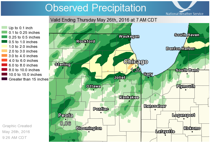 |
| Map of 24 Hour Observed Precipitation Ending at 7 AM May 26, 2016 |
Photos & Video:
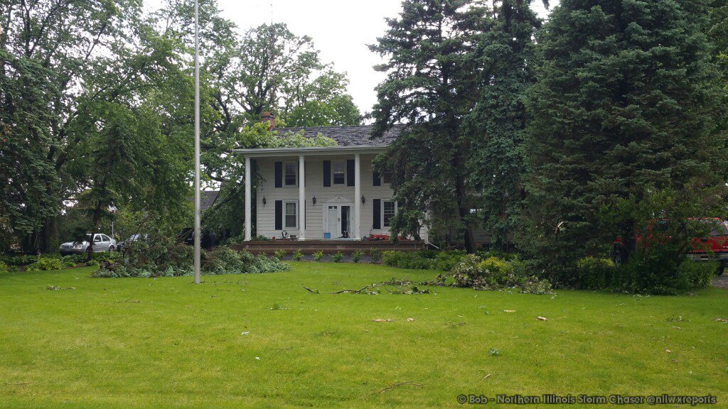
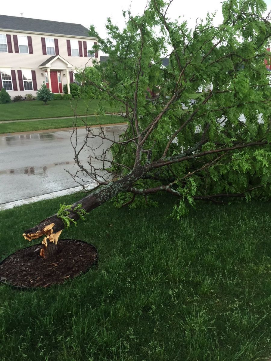
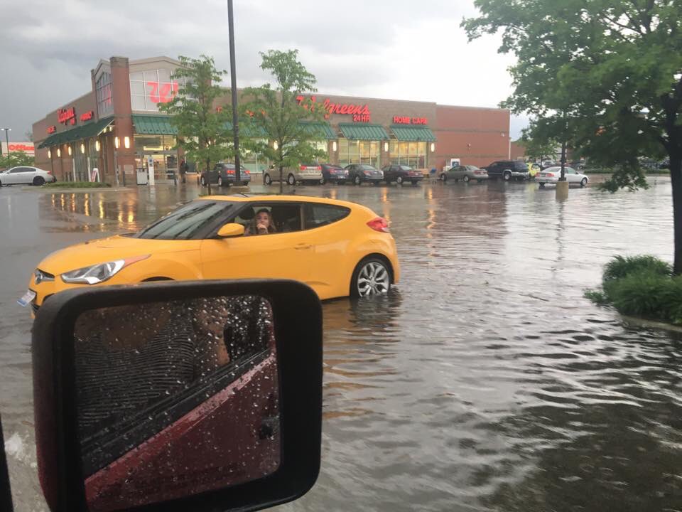
Photos of Damage
 |
 |
 |
| Trees down 2 miles north of Somonauk, IL |
Tree down in Sandwich, IL |
Flooding in Berwyn, IL |
Storm Reports
PRELIMINARY LOCAL STORM REPORT...SUMMARY
NATIONAL WEATHER SERVICE CHICAGO/ROMEOVILLE IL
554 AM CDT THU MAY 26 2016

..TIME...   ...EVENT...      ...CITY LOCATION...     ...LAT.LON...
..DATE...   ....MAG....      ..COUNTY LOCATION..ST.. ...SOURCE....
            ..REMARKS..

0256 PM     TSTM WND DMG     PLANO                   41.66N 88.53W
05/25/2016                   KENDALL            IL   TRAINED SPOTTER

            FOUR 6-8 INCH TREES UPROOTED AT HOFFMAN ST NEAR KRISTEN

0330 PM     HEAVY RAIN       LELAND                  41.61N 88.80W
05/25/2016  M0.80 INCH       LA SALLE           IL   TRAINED SPOTTER

            RAIN FELL IN 15 MINUTES.

0340 PM     TSTM WND DMG     LELAND                  41.61N 88.80W
05/25/2016                   LA SALLE           IL   TRAINED SPOTTER

            SMALL TREE BRANCHES DOWN. WINDS ESTIMATED AROUND 50 MPH.
            VERY HEAVY RAINFALL AND LOW VISIBILITY. HAIL AROUND PEA
            SIZE.

0353 PM     TSTM WND DMG     2 N SOMONAUK            41.66N 88.68W
05/25/2016                   DE KALB            IL   EMERGENCY MNGR

            AROUND TWO DOZEN TREES BLOWN OVER OR SPLIT. ONE TREE WAS
            5 FT IN DIAMETER. ONE TREE DOWN ON HOUSE AND CARS. TIME
            OF OCCURENCE ESTIMATED FROM RADAR.

0402 PM     TSTM WND GST     1 N SANDWICH            41.66N 88.62W
05/25/2016  E50.00 MPH       DE KALB            IL   TRAINED SPOTTER

            WINDS LASTED APPROXIMATELY 5 MINUTES. RELAYED VIA SOCIAL
            MEDIA.

0410 PM     HEAVY RAIN       1 ENE SUGAR GROVE       41.78N 88.44W
05/25/2016  M0.99 INCH       KANE               IL   COCORAHS

            RAIN FELL IN 20 MINUTES.

0414 PM     TSTM WND GST     SUGAR GROVE             41.77N 88.46W
05/25/2016  M50.00 MPH       KANE               IL   ASOS

0441 PM     TSTM WND GST     DUPAGE AIRPORT          41.92N 88.25W
05/25/2016  M60.00 MPH       DUPAGE             IL   ASOS

0457 PM     HAIL             WARRENVILLE             41.82N 88.19W
05/25/2016  M0.88 INCH       DUPAGE             IL   TRAINED SPOTTER

            IL RT 59 AND BATAVIA RD

0518 PM     HEAVY RAIN       WORTH                   41.69N 87.79W
05/25/2016  M0.52 INCH       COOK               IL   COCORAHS

            RAIN FELL IN PAST 13 MINUTES

0538 PM     HEAVY RAIN       3 SW MIDWAY AIRPORT     41.75N 87.79W
05/25/2016  M0.60 INCH       COOK               IL   CO-OP OBSERVER

            0.55 INCHES OF RAIN FELL IN 15 MINUTES. WIND GUST
            REPORTED TO 50 MPH.

0548 PM     TSTM WND GST     S CHICAGO               41.87N 87.63W
05/25/2016  E55.00 MPH       COOK               IL   NWS EMPLOYEE

0600 PM     FLOOD            AURORA                  41.77N 88.29W
05/25/2016                   KANE               IL   TRAINED SPOTTER

            4-6 INCHES OF STANDING WATER AT RT 25 AND INDIAN TRAIL
            ROAD AND 4 INCHES OF WATER ACROSS THE ROAD AT RT 31 AND
            INDIAN TRAIL ROAD.

0615 PM     HEAVY RAIN       2 NE NORTH AURORA       41.82N 88.30W
05/25/2016  M1.68 INCH       KANE               IL   COCORAHS

            STORM TOTAL SO FAR. 0.62 INCHES FELL IN THE PAST 30
            MINUTES.

0630 PM     HEAVY RAIN       1 NE SUGAR GROVE        41.78N 88.45W
05/25/2016  M2.16 INCH       KANE               IL   COCORAHS

            STORM TOTAL SO FAR

0725 PM     HEAVY RAIN       BERWYN                  41.84N 87.79W
05/25/2016  M2.30 INCH       COOK               IL   TRAINED SPOTTER

0545 AM     HEAVY RAIN       BERWYN                  41.84N 87.79W
05/26/2016  M3.23 INCH       COOK               IL   TRAINED SPOTTER


&&

$$

MTF
Rain Reports
PUBLIC INFORMATION STATEMENT
NATIONAL WEATHER SERVICE CHICAGO IL
0836 AM CDT THU MAY 26 2016

...MORNING RAINFALL ROUNDUP...

   THE FOLLOWING ARE RAIN AMOUNTS FOR THE PREVIOUS 24-HOURS
   AS MEASURED IN THE MORNING BY NWS COOPERATIVE OBSERVERS
   AND COCORAHS OBSERVERS.
   OBSERVATIONS ARE USUALLY TAKEN BETWEEN 6 AND 8 AM.

   24-HOUR RAINFALL AMOUNTS
       FOR THURSDAY(05/26/16)...


ILLINOIS                                       RAIN
  LOCATION (COUNTY):                           FALL (IN)

  OAK PARK 2S (COOK)...........................3.07
  OAK PARK 1SW (COOK)..........................2.96
  SUGAR GROVE 1ENE (KANE)......................2.53
  OAK PARK 1NNE (COOK).........................2.38
  RAVENSWOOD MANOR (COOK)......................2.37
  LINCOLNWOOD 2E (COOK)........................2.37
  ELMHURST 1ESE (DU PAGE)......................2.24
  AURORA (KANE)................................2.23
  ROGERS PARK 2SW (COOK).......................2.23
  SUGAR GROVE 1NE (KANE).......................2.19
  BUFFALO GROVE 2N (LAKE)......................2.12
  AURORA (KANE)................................2.04
  LA GRANGE PARK 1SSW (COOK)...................2.02
  DOWNERS GROVE 0.4NNE (DU PAGE)...............1.99
  ELMHURST 2SE (DU PAGE).......................1.92
  NORTH AURORA 2NE (KANE)......................1.82
  PLANO (KENDALL)..............................1.78
  GENEVA 4WSW (KANE)...........................1.78
  AURORA 4SE (DU PAGE).........................1.74
  AURORA 4SE (DU PAGE).........................1.73
  VILLA PARK 1NW (DU PAGE).....................1.73
  LAKE ZURICH (LAKE)...........................1.73
  BARRINGTON (LAKE)............................1.57
  HIGHWOOD 1S (LAKE)...........................1.56
  WESTMONT (DU PAGE)...........................1.53
  ELBURN (KANE)................................1.48
  EVANSTON 1N (COOK)...........................1.45
  LISLE 1SE (DU PAGE)..........................1.44
  BANNOCKBURN (LAKE)...........................1.42
  GLEN ELLYN (DU PAGE).........................1.38
  BURR RIDGE 2SW (DU PAGE).....................1.34
  LISLE MORTON ARB (DU PAGE)...................1.31
  ELGIN 2W (KANE)..............................1.30
  HOFFMAN ESTATES 5W (COOK)....................1.29
  ELGIN (KANE).................................1.27
  WINFIELD (DU PAGE)...........................1.24
  ELGIN 2WNW (KANE)............................1.17
  ST. CHARLES 6NW (KANE).......................1.15
  GENOA (DE KALB)..............................1.09
  BATAVIA 1WSW (KANE)..........................1.09
  MONTGOMERY 1SSE (KENDALL)....................1.08
  GLENCOE (COOK)...............................1.07
  GENEVA 1SSW (KANE)...........................1.06
  SOMONAUK 2NE (DE KALB).......................1.05
  WILLOW SPRINGS (COOK)........................1.03
  CAROL STREAM (DU PAGE).......................1.02
  MIDWAY (COOK)................................1.02
  RIVERWOODS (LAKE)............................1.00
  LAKE BLUFF 1W (LAKE).........................0.99
  BATAVIA 1WNW (KANE)..........................0.97
  NAPERVILLE 4SSW (WILL).......................0.96
  OHARE (COOK).................................0.95
  ELGIN (KANE).................................0.93
  ELGIN 1S (KANE)..............................0.93
  ELK GROVE VILLAGE 2WSW (COOK)................0.92
  WHEELING (COOK)..............................0.90
  BOTANIC GARDENS (COOK).......................0.88
  ARLINGTON HEIGHTS 1SW (COOK).................0.88
  ALGONQUIN 1N (MCHENRY).......................0.88
  ROCHELLE (OGLE)..............................0.85
  PLAINFIELD 2SSE (WILL).......................0.82
  BLOOMINGDALE 1NNE (DU PAGE)..................0.81
  PLAINFIELD 3NNW (WILL).......................0.80
  CORTLAND (DE KALB)...........................0.76
  MIDWAY COOP (COOK)...........................0.73
  MUNDELEIN (LAKE).............................0.73
  ROCHELLE (OGLE)..............................0.73
  PARK RIDGE 1WNW (COOK).......................0.70
  PLAINFIELD 1SW (WILL)........................0.70
  OSWEGO 5SSE (KENDALL)........................0.69
  GILBERTS (KANE)..............................0.63
  MUNDELEIN 2WNW (LAKE)........................0.62
  STEWARD (LEE)................................0.60
  YORKVILLE 2SE (KENDALL)......................0.59
  PLAINFIELD (WILL)............................0.58
  WEST CHICAGO (DU PAGE).......................0.57
  CARY (MCHENRY)...............................0.57
  WOODSTOCK 1SSW (MCHENRY).....................0.57
  WORTH (COOK).................................0.53
  WAUKEGAN 2N (LAKE)...........................0.53
  WAUKEGAN (LAKE)..............................0.53
  CHICAGO RIDGE (COOK).........................0.52
  OAK LAWN 2WNW (COOK).........................0.52
  BEACH PARK 1W (LAKE).........................0.52
  ZION (LAKE)..................................0.51
  DE KALB (DE KALB)............................0.47
  WINTHROP HARBOR 1SSW (LAKE)..................0.47
  CHANNAHON 2SSE (WILL)........................0.47
  LAKE VILLA 1SSW (LAKE).......................0.43
  POLO (OGLE)..................................0.43
  HARVARD (MCHENRY)............................0.38
  CHEBANSE (KANKAKEE)..........................0.38
  LAKEMOOR 2SE (LAKE)..........................0.36
  FOX LAKE 2SE (LAKE)..........................0.36
  ROCKFORD 1NW (WINNEBAGO).....................0.36
  PLAINFIELD 5SW (KENDALL).....................0.34
  WOODSTOCK (MCHENRY)..........................0.33
  CAPRON (BOONE)...............................0.32
  MCHENRY (MCHENRY)............................0.32
  HOMER GLEN 1ENE (WILL).......................0.26
  BELVIDERE (BOONE)............................0.25
  LANSING (COOK)...............................0.24
  JOLIET 3WNW (WILL)...........................0.23
  ROCKFORD (WINNEBAGO).........................0.21
  ASHTON (LEE).................................0.20
  WILMINGTON 6NW (WILL)........................0.20
  ROMEOVILLE (WILL)............................0.20
  DIXON 2SW (LEE)..............................0.19
  DIXON 3NNW (LEE).............................0.18
  DIXON (LEE)..................................0.17
  PEOTONE (WILL)...............................0.16
  PEOTONE (WILL)...............................0.16
  BEECHER 3ENE (WILL)..........................0.14
  ALSIP (COOK).................................0.13
  ELMHURST (DU PAGE)...........................0.12
  ROSCOE 2ESE (WINNEBAGO)......................0.11
  ROSCOE 2SE (WINNEBAGO).......................0.11
  NEW LENOX 4SE (WILL).........................0.09
  ELWOOD 5NE (WILL)............................0.08
  JOLIET (WILL)................................0.08
  AMBOY (LEE)..................................0.07
  MANHATTAN (WILL).............................0.06
  BEECHER 3SSE (WILL)..........................0.05
  PARK FOREST 1SW (COOK).......................0.04
  DWIGHT (LIVINGSTON)..........................0.03
  LOCKPORT 1SE (WILL)..........................0.03
  NEW LENOX 3E (WILL)..........................0.03
  STREATOR (LIVINGSTON)........................0.03
  JOLIET LOCK/DAM (WILL).......................0.02
  COAL CITY 4NNW (GRUNDY)......................0.01
  CARBON HILL 3.1N (GRUNDY)....................0.01
  MORRIS 5NNW (GRUNDY).........................0.01
  GIBSON 3WNW (FORD)..........................TRACE
  BRACEVILLE (GRUNDY).........................TRACE
  MORRIS 6ESE (GRUNDY)........................TRACE
  ASHKUM 5.6E (IROQUOIS)......................TRACE
  WATSEKA 6.9WNW (IROQUOIS)...................TRACE
  BONFIELD 4WSW (KANKAKEE)....................TRACE
  OTTAWA 1NW (LA SALLE).......................TRACE
  MENDOTA 2SE (LA SALLE)......................TRACE
  PARK FOREST (COOK)..........................TRACE

INDIANA                                        RAIN
  LOCATION (COUNTY):                           FALL (IN)

  (WV90)HOBART 1ENE (LAKE).....................0.71
  GARY 5ENE (LAKE).............................0.43
  HOBART 1NNW (LAKE)...........................0.32
  VALPARAISO 2WNW (PORTER).....................0.21
  VALPARAISO 3WSW (PORTER).....................0.19
  VALPARAISO 4SW (PORTER)......................0.16
  PORTAGE 1ESE (PORTER)........................0.15
  ST. JOHN (LAKE)..............................0.13
  (KB9F)VALPARAISO 4S (PORTER).................0.13
  DYER 1WNW (LAKE).............................0.12
  VALPARAISO 7WSW (PORTER).....................0.12
  PORTAGE 3E (PORTER)..........................0.10
  GARY 4SSW (LAKE).............................0.06
  LAKES OF THE FOUR SEASONS 2NNE (PORTER)......0.06
  VALPARAISO (PORTER)..........................0.04
  HEBRON 4NE (PORTER)..........................0.03
  VALPARAISO 6WSW (PORTER).....................0.03
  (W9MAL)MERRILLVILLE 2NNW (LAKE)..............0.01
  DE MOTTE 1NNW (JASPER)......................TRACE
 |
Media use of NWS Web News Stories is encouraged! Please acknowledge the NWS as the source of any news information accessed from this site. |
|

