Severe thunderstorms and flash flooding risks increase across the center of the nation today. Meanwhile, ongoing thunderstorms and flash flooding will linger along the Gulf Coast states through the evening. The Great Basin and Intermountain West, warm temperatures and dry fuels with dry lightning may enhance fire weather potential. In addition, across interior Alaska, Red Flag Warning are posted. Read More >
Overview
|
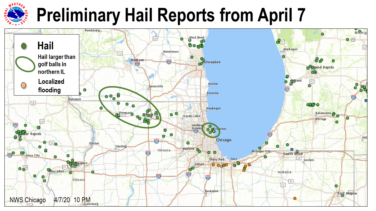
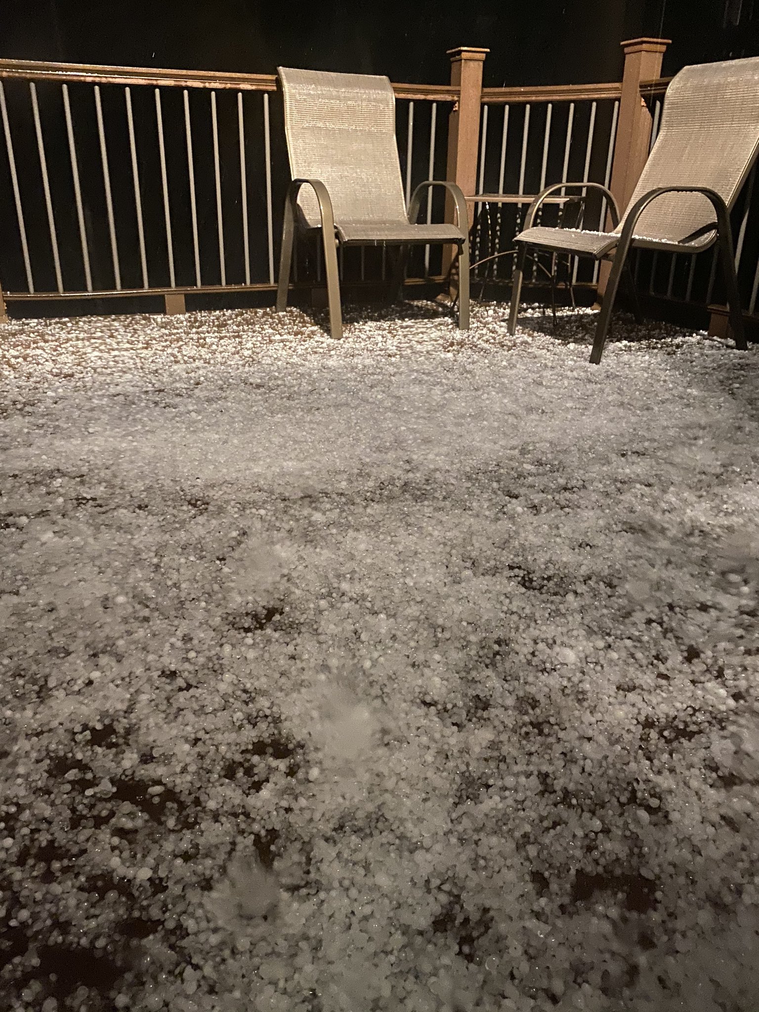
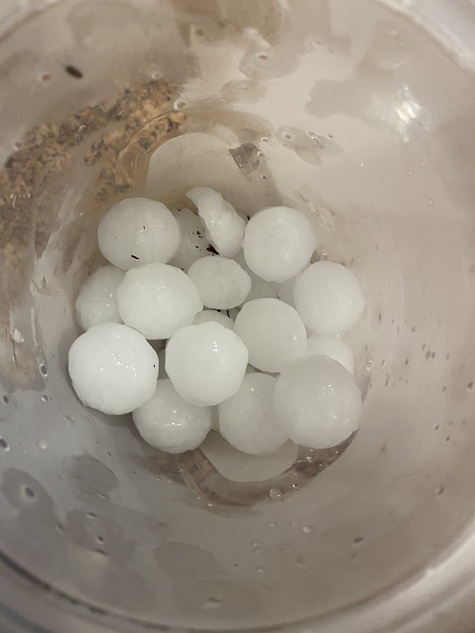
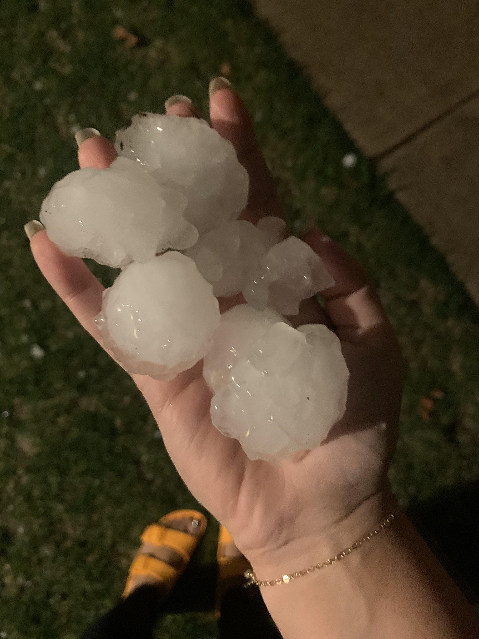
An unseasonably warm and humid air mass fueled explosive thunderstorm development along a cold front during the late afternoon of April 7th. Thunderstorms initially developed over southern Wisconsin during the afternoon then slowly moved south into northern Illinois. The storms were prolific hail producers, with particularly large hail in the Rockford area as well as across some of the near northern Chicago suburbs. Numerous reports of hail 1" in diameter or larger were received with the most intense storms producing hail of 2 to 3 inches in diameter!
Additional information about the storms that hit eastern Iowa: |
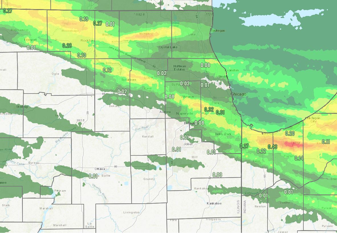
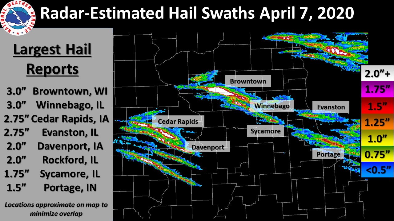 Radar-estimated hail swaths and largest hail reports across Iowa, Wisconsin, and Illinois, during the evening hours of April 7, 2020. |
Photos & Video:
 |
 |
 |
 |
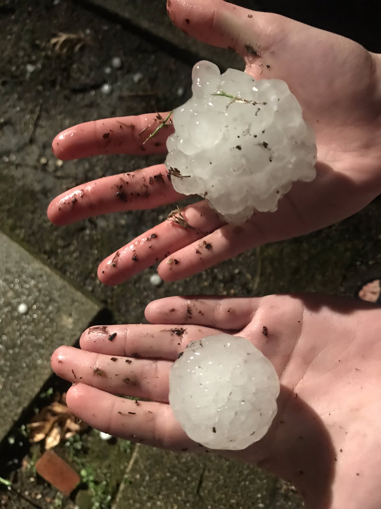
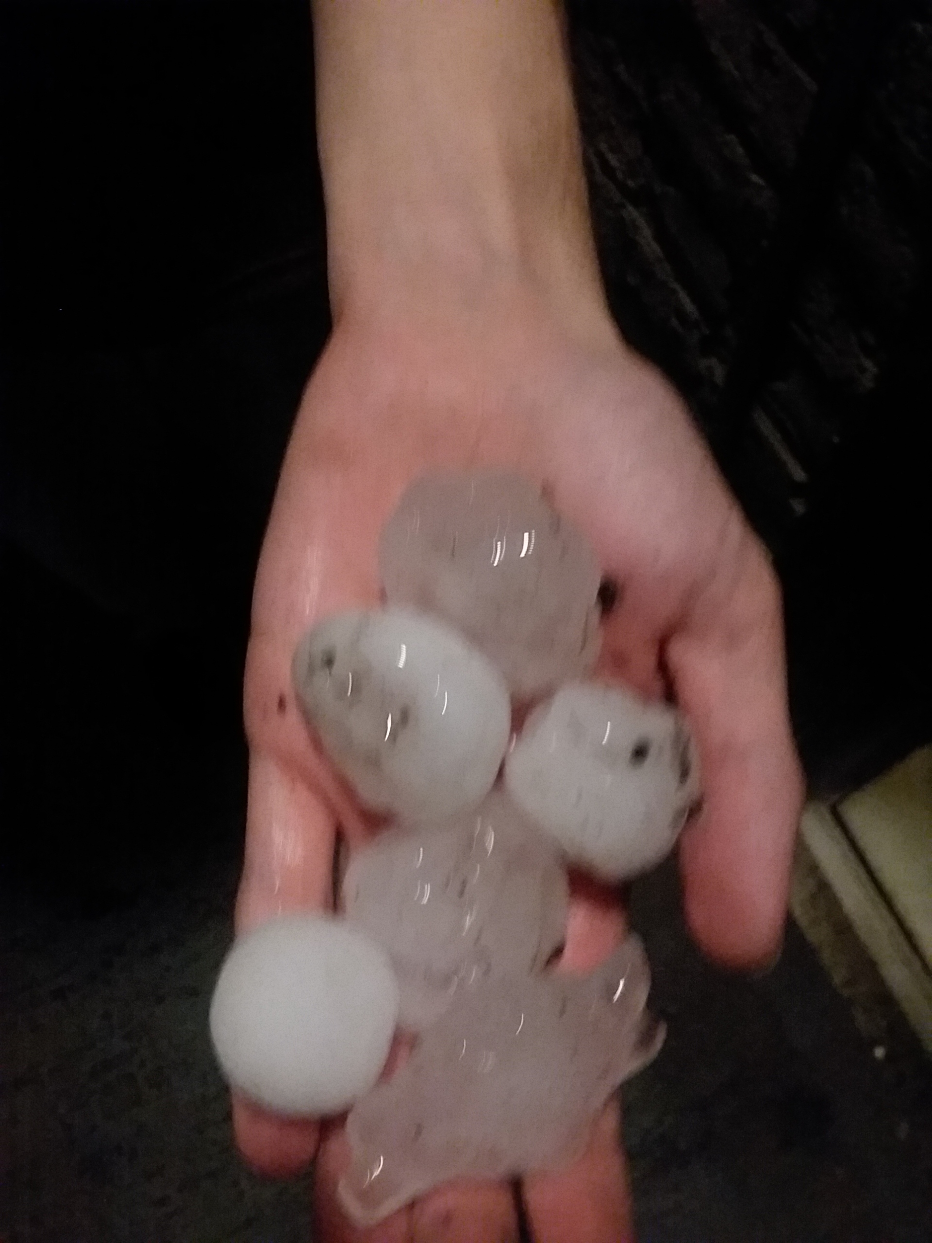
| Large hail in Evanston, IL from Mark Caro |
Large hail in Evanston, IL from Rick DiMaio |
Large Hail near Rockford, IL from Lou Bauscher |
Large hail near Sycamore Illinois from a Nate Knorrek |
 |
 |
 |
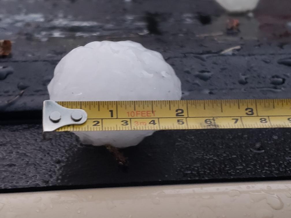
| Large hail near Valparaiso, IN from Mark Meyer |
Large hail near Valparaiso, IN from Mark Meyer |
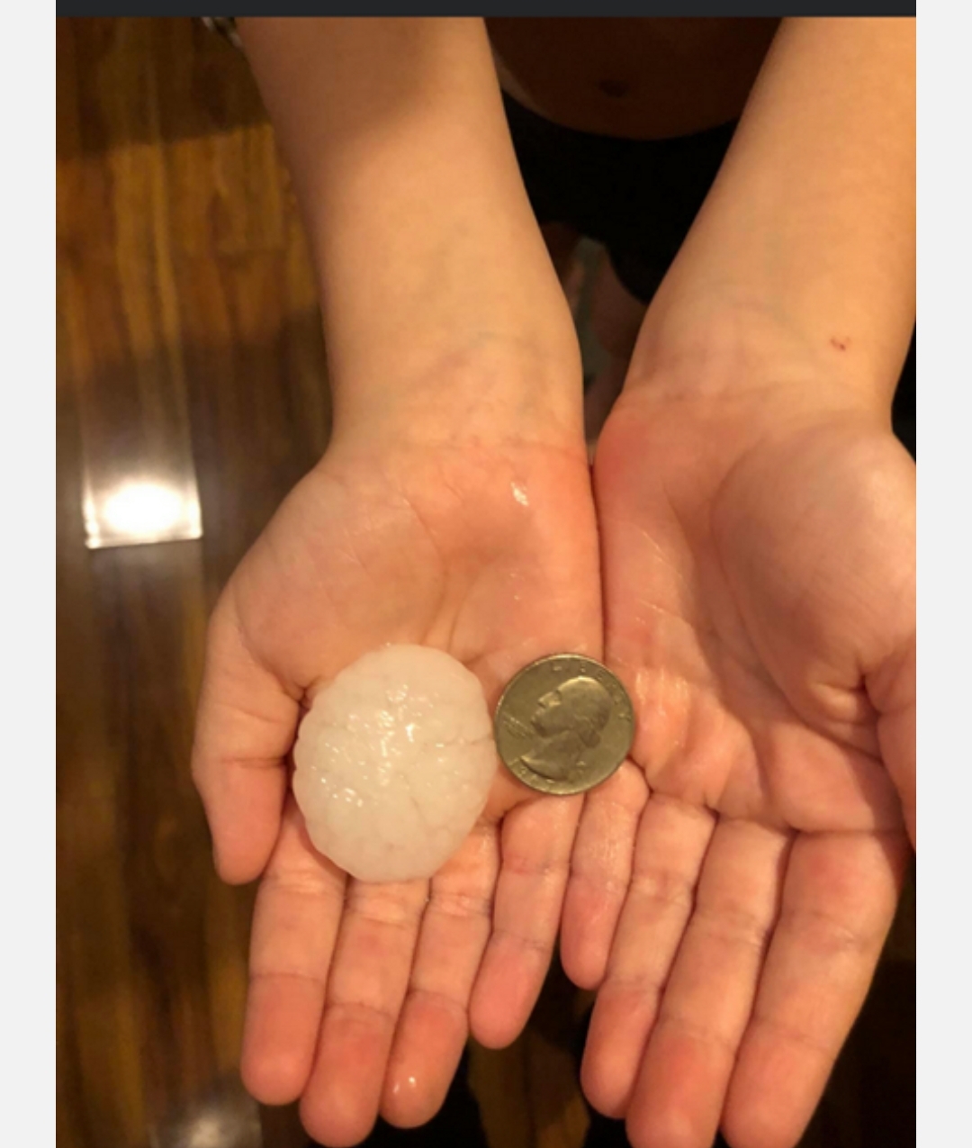
Large hail in Skokie, IL from Jasar Zvizdic |
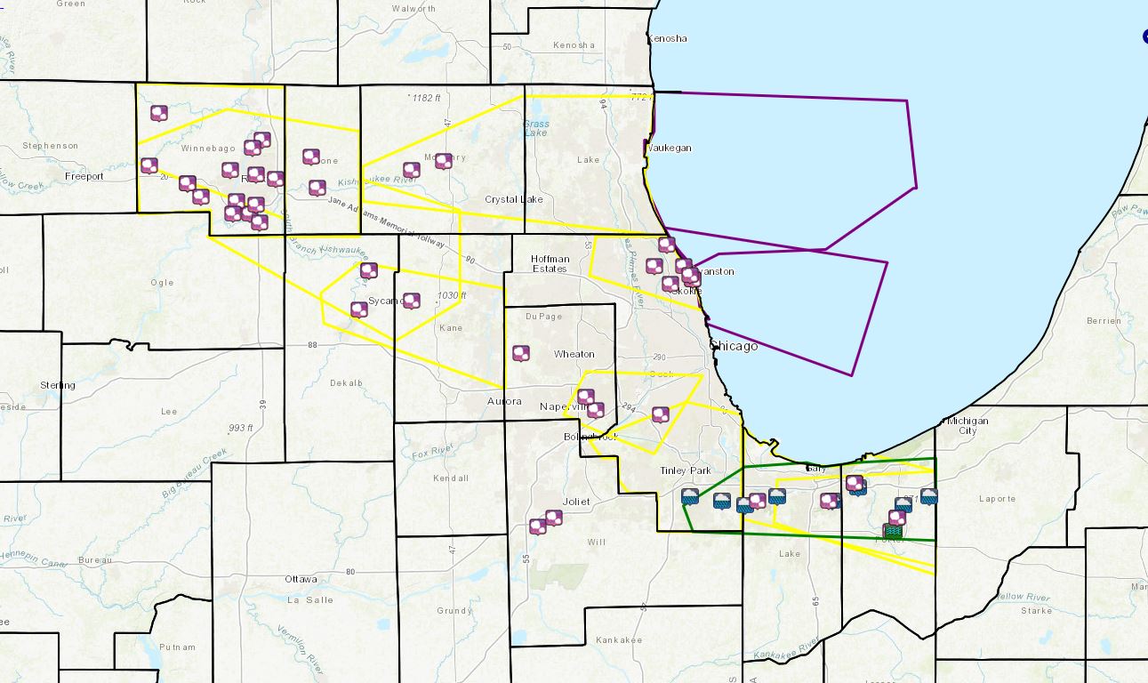
Storm Reports
|
||||||||||
PRELIMINARY LOCAL STORM REPORT...SUMMARY
NATIONAL WEATHER SERVICE CHICAGO IL
1210 AM CDT WED APR 8 2020

..TIME...   ...EVENT...      ...CITY LOCATION...     ...LAT.LON...
..DATE...   ....MAG....      ..COUNTY LOCATION..ST.. ...SOURCE....
            ..REMARKS..

0935 PM     HAIL             2 NNE VALPARAISO        41.50N 87.05W
04/07/2020  U0.88 INCH       PORTER             IN   TRAINED SPOTTER

            CORRECTS PREVIOUS HAIL REPORT FROM 2 NNE
            VALPARAISO. NUMEROUS REPORTS OF HAIL BETWEEN
            NICKEL AND QUARTER SIZE IN NORTH SECTIONS OF
            VALPARAISO.

0935 PM     FLOOD            VALPARAISO              41.47N 87.06W
04/07/2020                   PORTER             IN   TRAINED SPOTTER

            SPOTTER REPORTED 1 HAIL, 50 MPH WINDS, AND
            MINOR FLOODING OF LOW-LYING AREAS.

0935 PM     HAIL             1 W VALPARAISO          41.47N 87.07W
04/07/2020  E1.50 INCH       PORTER             IN   PUBLIC

            RELAYED VIA SOCIAL MEDIA AND TIME ESTIMATED
            BY RADAR.

0907 PM     HAIL             PORTAGE                 41.58N 87.18W
04/07/2020  M1.50 INCH       PORTER             IN   TRAINED SPOTTER

            TIME ESTIMATED VIA RADAR.

0905 PM     HAIL             1 NNW PORTAGE           41.58N 87.18W
04/07/2020  U1.25 INCH       PORTER             IN   TRAINED SPOTTER

            TIME ESTIMATED VIA RADAR.

0903 PM     HAIL             1 NW PORTAGE            41.58N 87.18W
04/07/2020  M1.00 INCH       PORTER             IN   TRAINED SPOTTER


0515 AM     HEAVY RAIN       7 SE CHESTERTON         41.55N 86.95W
04/07/2020  M1.19 INCH       PORTER             IN   PUBLIC

            PRECIPITATION SINCE MIDNIGHT 4/7. WUNDERMAP
            STATION ID LOMWESTV9.

0514 AM     HEAVY RAIN       PORTAGE                 41.57N 87.17W
04/07/2020  M1.04 INCH       PORTER             IN   PUBLIC

            PRECIPITATION SINCE MIDNIGHT 4/7. WUNDERMAP
            STATION ID KINPORTA46.

0514 AM     HEAVY RAIN       4 NNE VALPARAISO        41.53N 87.03W
04/07/2020  M1.39 INCH       PORTER             IN   PUBLIC

            PRECIPITATION SINCE MIDNIGHT 4/7. WUNDERMAP
            STATION ID KINVALPA65.

0935 PM     HAIL             1 SW HIGHLAND           41.54N 87.48W
04/07/2020  U1.00 INCH       LAKE               IN   PUBLIC

            PUBLIC REPORT SENT VIA MPING.

0830 PM     HAIL             HOBART                  41.54N 87.26W
04/07/2020  U1.00 INCH       LAKE               IN   TRAINED SPOTTER

            TIME ESTIMATED VIA RADAR.

0513 AM     HEAVY RAIN       1 SW MUNSTER            41.53N 87.52W
04/07/2020  M1.60 INCH       LAKE               IN   PUBLIC

            PRECIPITATION SINCE MIDNIGHT 4/7. WUNDERMAP
            STATION ID KINMUNST9.

0513 AM     HEAVY RAIN       1 NNE HOBART            41.54N 87.25W
04/07/2020  M1.78 INCH       LAKE               IN   PUBLIC

            PRECIPITATION SINCE MIDNIGHT 4/7. WUNDERMAP
            STATION ID KINHOBART18.

0512 AM     HEAVY RAIN       1 NNE GRIFFITH          41.55N 87.42W
04/07/2020  M1.35 INCH       LAKE               IN   PUBLIC

            PRECIPITATION SINCE MIDNIGHT 4/7. WUNDERMAP
            STATION ID KINHIGHL12.

0728 PM     HAIL             2 E NEW MILFORD         42.18N 89.02W
04/07/2020  U2.00 INCH       WINNEBAGO          IL   PUBLIC

            PUBLIC REPORT OF 2 IN HAIL ALONG I-39 NEAR
            NEW MILFORD.

0728 PM     HAIL             3 NNE NEW MILFORD       42.22N 89.03W
04/07/2020  E1.50 INCH       WINNEBAGO          IL   PUBLIC

            PICTURE SHARED VIA SOCIAL MEDIA OF HAIL
            LARGER THAN QUARTER SIZE NEAR LINDEN RD AND
            35TH STREET. TIME ESTIMATED VIA RADAR.

0726 PM     HAIL             ROCKFORD AIRPORT        42.20N 89.10W
04/07/2020  M1.25 INCH       WINNEBAGO          IL   TRAINED SPOTTER


0724 PM     HAIL             2 N ROCKFORD AIRPORT    42.23N 89.09W
04/07/2020  E1.00 INCH       WINNEBAGO          IL   PUBLIC


0721 PM     HAIL             2 NNE NEW MILFORD       42.20N 89.05W
04/07/2020  M1.75 INCH       WINNEBAGO          IL   TRAINED SPOTTER


0719 PM     HAIL             3 NNW CHERRY VALLEY     42.28N 88.97W
04/07/2020  M1.00 INCH       WINNEBAGO          IL   TRAINED SPOTTER


0717 PM     HAIL             3 SE WINNEBAGO          42.24N 89.20W
04/07/2020  M2.00 INCH       WINNEBAGO          IL   PUBLIC

            PICTURE SHARED ON SOCIAL MEDIA OF 2 IN HAIL
            SOUTHEAST OF WINNEBAGO.

0715 PM     HAIL             WINNEBAGO               42.27N 89.24W
04/07/2020  E3.00 INCH       WINNEBAGO          IL   TRAINED SPOTTER

            DAMAGE TO SIDING AND CARS FROM HAIL. LARGEST
            WERE APPROXIMATELY 3 INCHES IN DIAMETER.

0715 PM     HAIL             2 NNW ROCKFORD          42.30N 89.11W
04/07/2020  M1.00 INCH       WINNEBAGO          IL   TRAINED SPOTTER


0712 PM     HAIL             MACHESNEY PARK          42.35N 89.04W
04/07/2020  M1.00 INCH       WINNEBAGO          IL   TRAINED SPOTTER


0710 PM     HAIL             WINNEBAGO               42.27N 89.24W
04/07/2020  M2.00 INCH       WINNEBAGO          IL   TRAINED SPOTTER


0710 PM     HAIL             2 SE LOVES PARK         42.29N 89.03W
04/07/2020  U1.75 INCH       WINNEBAGO          IL   PUBLIC

            PUBLIC REPORT VIA MPING.

0709 PM     HAIL             PECATONICA              42.31N 89.36W
04/07/2020  M1.00 INCH       WINNEBAGO          IL   BROADCAST MEDIA


0707 PM     HAIL             2 NE MACHESNEY PARK     42.37N 89.01W
04/07/2020  U1.50 INCH       WINNEBAGO          IL   PUBLIC

            PUBLIC REPORT VIA MPING.

0640 PM     HAIL             DURAND                  42.43N 89.33W
04/07/2020  E1.75 INCH       WINNEBAGO          IL   PUBLIC

            MULTIPLE PICTURES SHARED VIA SOCIAL MEDIA OF
            HAIL UP TO GOLF BALL SIZE NEAR LAKE
            SUMMERSET AND DURAND. TIME ESTIMATED BY
            RADAR.

0120 AM     HAIL             ROCKDALE                41.50N 88.11W
04/07/2020  E0.70 INCH       WILL               IL   PUBLIC

            TIME ESTIMATED BY RADAR.

1226 AM     HAIL             3 SW ROCKDALE           41.48N 88.16W
04/07/2020  E0.25 INCH       WILL               IL   EMERGENCY MNGR


0712 PM     HAIL             WOODSTOCK               42.32N 88.45W
04/07/2020  M1.00 INCH       MCHENRY            IL   TRAINED SPOTTER


0659 PM     HAIL             4 NE MARENGO            42.30N 88.55W
04/07/2020  U1.00 INCH       MCHENRY            IL   PUBLIC

            PUBLIC REPORT VIA MPING.

0847 PM     HAIL             3 S BURLINGTON          42.00N 88.55W
04/07/2020  M1.00 INCH       KANE               IL   EMERGENCY MNGR

            TIME ESTIMATED VIA RADAR.

0915 PM     HAIL             WEST CHICAGO            41.88N 88.21W
04/07/2020  U1.00 INCH       DUPAGE             IL   PUBLIC

            PUBLIC REPORT VIA MPING.

0820 PM     HAIL             1 S DOWNERS GROVE       41.78N 88.01W
04/07/2020  E0.88 INCH       DUPAGE             IL   PUBLIC

            PHOTOS SHARED VIA SOCIAL MEDIA OF HAIL
            BETWEEN DIME AND QUARTER SIZE IN DOWNERS
            GROVE.

0820 PM     HAIL             DARIEN                  41.75N 87.98W
04/07/2020  U1.00 INCH       DUPAGE             IL   PUBLIC

            TIME ESTIMATED VIA RADAR.

0843 PM     HAIL             1 WSW SYCAMORE          41.98N 88.71W
04/07/2020  U1.75 INCH       DE KALB            IL   TRAINED SPOTTER

            NEAR PEACE ROAD AND IL-23.

0802 PM     HAIL             2 SSE GENOA             42.07N 88.68W
04/07/2020  M1.00 INCH       DE KALB            IL   TRAINED SPOTTER


0800 PM     HAIL             2 S GENOA               42.07N 88.68W
04/07/2020  U1.00 INCH       DE KALB            IL   PUBLIC

            MULTIPLE PUBLIC REPORTS OF 1 IN DIAMETER
            HAIL JUST SOUTH OF GENOA.

0832 PM     HAIL             1 NNE EVANSTON          42.06N 87.69W
04/07/2020  U1.50 INCH       COOK               IL   BROADCAST MEDIA

            NUMEROUS ADDITIONAL PUBLIC REPORTS OF HAIL
            LARGER THAN QUARTER SIZE IN VICINITY. TIME
            ESTIMATED VIA RADAR.

0832 PM     HAIL             EVANSTON                42.05N 87.68W
04/07/2020  M1.75 INCH       COOK               IL   PUBLIC

            NUMEROUS PICTURES SHARED VIA SOCIAL MEDIA OF
            HAIL UP TO GOLF BALL SIZE IN EVANSTON. TIME
            ESTIMATED BY RADAR.

0832 PM     HAIL             1 NE EVANSTON           42.05N 87.68W
04/07/2020  M2.75 INCH       COOK               IL   PUBLIC

            MULTIPLE PHOTOS SHARED VIA SOCIAL MEDIA OF
            HAIL UP TO BASEBALL SIZE IN EVANSTON.
            DELAYED REPORT, TIME ESTIMATED VIA RADAR.

0828 PM     HAIL             1 NW SKOKIE             42.04N 87.75W
04/07/2020  U1.00 INCH       COOK               IL   PUBLIC

            PUBLIC REPORT VIA MPING.

0827 PM     HAIL             1 E WILMETTE            42.08N 87.71W
04/07/2020  M1.50 INCH       COOK               IL   EMERGENCY MNGR

            TIME ESTIMATED BY RADAR.

0825 PM     HAIL             1 ESE GLENVIEW          42.08N 87.80W
04/07/2020  M1.00 INCH       COOK               IL   TRAINED SPOTTER


0822 PM     HAIL             3 SW MIDWAY AIRPORT     41.74N 87.78W
04/07/2020  M1.00 INCH       COOK               IL   CO-OP OBSERVER

            GUSTS UP TO 40 MPH.

0812 PM     HAIL             GLENCOE                 42.13N 87.76W
04/07/2020  E0.88 INCH       COOK               IL   TRAINED SPOTTER

            TRAINED SPOTTER ESTIMATES HAIL OF 0.88-1.00
            IN DIAMETER. TIME ESTIMATED BY RADAR.

0515 AM     HEAVY RAIN       1 NNW FLOSSMOOR         41.55N 87.69W
04/07/2020  M0.98 INCH       COOK               IL   PUBLIC

            PRECIPITATION SINCE MIDNIGHT 4/7. WUNDERMAP
            STATION ID KINHIGHL12.

0515 AM     HEAVY RAIN       1 ESE GLENWOOD          41.54N 87.59W
04/07/2020  M1.59 INCH       COOK               IL   PUBLIC

            TOTAL RAINFALL SINCE MIDNIGHT. STATION ID
            KILGLENW1.

0737 PM     HAIL             BELVIDERE               42.26N 88.84W
04/07/2020  M1.00 INCH       BOONE              IL   TRAINED SPOTTER


0725 PM     HAIL             TIMBERLANE              42.33N 88.86W
04/07/2020  M1.25 INCH       BOONE              IL   TRAINED SPOTTER
|
Rain Reports
 |
| Rainfall |
Maximum/Minimum Temperature and Precipitation Table
National Weather Service Chicago/Romeoville IL
1004 AM CDT Wed Apr 8 2020

High temperature yesterday
Low temperature last 12 hours
Precipitation last 24 hours
Snowfall last 24 hours

.BR LOT 0408 C DH01/TAIRZX/DH07/TAIRZP/PPDRZZ/SFDRZZ

:ID Location                    High   Low     Pcpn  Snowfall
ORD: Chicago-O`Hare           :  80  /  51  /  0.01  / 0.0
CNII2: Chicago-Northerly Isl  :  78  /  45  /
MDW: Chicago-Midway           :  80  /  50  /  0.31
LOTI2: NWS Chicago-Romeoville :  79  /  52  /  0.00  / 0.0
RFD: Rockford Airport         :  78  /  45  /  0.10  / 0.0
DPA: DuPage Airport           :  80  /  50  /  0.08
UGN: Waukegan Airport         :  79  /  43  /     T
ARR: Aurora/Sugar Grove       :  79  /  49  /  0.00
PWK: Wheeling/CHI Exec        :  80  /  48  /  0.08
VPZ: Valparaiso IN            :  79  /  50  /  0.14
:
:Unofficial Supplemental AWOS Locations
:
DKB: DeKalb                   :   M  /  50  /
JOT: Joliet                   :  81  /  53  /
IKK: Kankakee                 :  80  /  51  /
IGQ: Lansing                  :  78  /  49  /
VYS: Peru                     :  81  /  50  /
PNT: Pontiac                  :  82  /  51  /
RZL: Rensselaer IN            :  79  /  50  /
RPJ: Rochelle                 :  78  /  44  /
06C: Schaumburg               :   M  /  48  /
:
:Additional Supplemental Automated Locations
:
SBNI2: Shabbona 5NNE          :  79  /  45  /
WMGI2: Wilmington-Midewin     :  82  /  52  /
.END

The following data provided by National Weather Service cooperative
observers. 24 hr temperatures and precipitation ending at indicated
time this morning. Locations are grouped by climatic division.


.BR LOT 0408 C DH07/TAIRZX/TAIRZN/PPDRZZ/SFDRZZ/SDIRZZ

:                                                  Snow  Snow
:Location               Date/Time  Max  Min  Pcpn  Fall  Depth
:Northeast Illinois...
ARRI2: Aurora         :   DH0700/  80 / 52 / 0.00 /  0.0/    0
BARI2: Barrington 3SW :   DH0800/  78 / 47 / 0.03 /  0.0/    0
DEKI2: DeKalb         :   DH0700/  78 / 53 / 0.01 /  0.0/    0
ELGI2: Elgin          :   DH0700/  78 / 50 / 0.02 /  0.0/    0
GEOI2: Genoa          :   DH0600/     /    / 0.28 /  0.0/    0
JOLI2: Joliet Lock/Dam:   DH0600/  79 / 51 / 0.00 /  0.0/    0
WHTI2: Lisle Mortn Arb:   DH0700/  79 / 49 / 0.02 /  0.0/    0
MATI2: Manhattan  5NE :   DH0800/     /    / 0.00 /  0.0/    0
MDTI2: Mendota        :   DH0600/     /    / 0.00 /  0.0/    0
MHYI2: McHenry        :   DH0800/  82 / 46 / 0.20 /  0.0/    0
MFWI2: Midway Coop    :   DH0700/  80 / 50 / 0.51 /  0.0/    0
MMOI2: Marseilles     :   DH0600/  66 /    / 0.00 /  0.0/    0
MOSI2: Morris         :   DH0800/  81 / 53 / 0.00 /  0.0/    0
MUNI2: Mundelein      :   DH0700/  78 / 45 /    T /  0.0/    0
OTTI2: Ottawa 4SW     :   DH0746/  79 / 51 / 0.00 /  0.0/    0
PKFI2: Park Forest    :   DH0500/  79 / 50 / 0.04 /  0.0/    0
PEOI2: Peotone        :   DH0700/     /    / 0.00 /  0.0/    0
STAI2: Streator       :   DH0700/  77 / 55 / 0.00 /  0.0/    0
WODI2: Woodstock 5NW  :   DH0700/     /    / 0.08 /  0.0/    0
:                                                  Snow  Snow
:Location               Date/Time  Max  Min  Pcpn  Fall  Depth
:Northwest Illinois...
PAWI2: Paw Paw        :   DH0700/  78 / 48 / 0.00 /  0.0/    0
RSCI2: Roscoe         :   DH0630/     /    / 0.45 /  0.0/    0
STWI2: Steward        :   DH0700/     /    / 0.00 /  0.0/    0
:                                                  Snow  Snow
:Location               Date/Time  Max  Min  Pcpn  Fall  Depth
:Northwest Indiana...
CRPI3: Crown Point    :   DH0630/     /    / 0.12 /    T/    0
RZZI3: Rensselaer     :   DH0730/  80 /    / 0.00 /  0.0/    0
:                                                  Snow  Snow
:Location               Date/Time  Max  Min  Pcpn  Fall  Depth
:Eastern Illinois...
BOUI2: Bourbonnais    :   DH0700/     /    / 0.00 /  0.0/    0
CHTI2: Chatsworth     :   DH0700/     /    / 0.00 /  0.0/    0
CWWI2: Dwight         :   DH0700/  80 / 50 / 0.00 /  0.0/    0
KKEI2: Kankakee       :   DH0700/  80 / 51 / 0.00 /  0.0/    0
PXNI2: Paxton         :   DH0630/  80 / 50 / 0.00 /  0.0/    0
SAAI2: St Anne        :   DH0700/     /    / 0.00 /  0.0/    0
WATI2: Watseka        :   DH0700/  80 / 54 / 0.00 /  0.0/    0
.END
Other Additional Supplementary Reports
                                                   Snow  Snow
:Location               Date/Time  Max  Min  Pcpn  Fall  Depth
BATI2: Batavia        :   DH0600/  80 / 52 /    T /  0.0/    0
CTYI2: Coal City 4NNW :   DH0700/  82 / 53 /    T /  0.0/    0
EGNI2: Elgin          :   DH0800/     /    / 0.05 /  0.0/    0
HEBI2: Hebron         :   DH0700/     /    / 0.01 /  0.0/    0
LKZI2: Lake Zurich    :   DH0700/     /    / 0.05 /  0.0/    0
WJWI2: Westmont       :   DH0700/     /    / 0.15 /  0.0/    0

Soil temperatures at 4 inch depth under bare soil
:Location                Max  Min
WATI2: Watseka        :   56 / 47
:
Soil temperatures at 4 inch depth under sod
:Location                Max  Min
:

These data are preliminary and have not undergone final quality
control by the National Center for Environmental Information /NCEI/.
Therefore... these data are subject to revision. Final and certified
climate data can be accessed at www.ncei.noaa.gov.
Additional Info
 |
Media use of NWS Web News Stories is encouraged! Please acknowledge the NWS as the source of any news information accessed from this site. Additional recaps can be found on the NWS Chicago Past Events Page |
|