
Dangerous heat will expand from the Gulf Coast into the Southern Plains and Desert Southwest through week's end. Additional extreme heat impacting the Pacific Northwest will shift to the northern Plains by the weekend. Tropical Storm Bertha is expected to continue to impact portions of the northern Gulf Coast from the western Florida Panhandle to southeastern Louisiana through tonight. Read More >
Overview
|
Fast Facts: Thunderstorms brought torrential rain, flash flooding, hail and damaging winds to northern Illinois Friday afternoon and evening. Radar estimates and surface rainfall measurements indicate a swath of 3-8" of rain fell roughly along the I-80 corridor.
|
|
Storm Reports
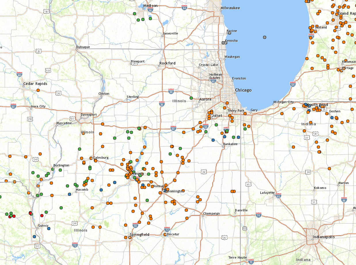 |
| Flooding (orange), Wind (blue) and Hail (green) Reports for the 24 hour period ending 8 AM Saturday September 28, 2019 |
PRELIMINARY LOCAL STORM REPORT
NATIONAL WEATHER SERVICE CHICAGO/ROMEOVILLE IL


..TIME...   ...EVENT...      ...CITY LOCATION...     ...LAT.LON...
..DATE...   ....MAG....      ..COUNTY LOCATION..ST.. ...SOURCE....
            ..REMARKS..
0911 AM     HEAVY RAIN       PALOS PARK              41.67N 87.83W
09/28/2019  M3.20 INCH       COOK               IL   TRAINED SPOTTER
0723 AM     HEAVY RAIN       PARK FOREST             41.48N 87.69W
09/28/2019  M6.75 INCH       COOK               IL   TRAINED SPOTTER
0712 AM     HEAVY RAIN       STREATOR                41.12N 88.84W
09/28/2019  M8.44 INCH       LA SALLE           IL   TRAINED SPOTTER
0810 PM     FLASH FLOOD      1 SSW CROWN POINT       41.41N 87.37W
09/27/2019                   LAKE               IN   TRAINED SPOTTER

            STREET FLOODING MULTIPLE FEET DEEP NEAR LAKE
            STREET AND GREENWOOD AVENUE IN CROWN POINT.

0800 PM     FLOOD            3 NNE HIGHLAND          41.59N 87.44W
09/27/2019                   LAKE               IN   PUBLIC

            PUBLIC REPORTS STREET FLOODING UP TO 6
            INCHES DEEP NEAR CLINE AND 169TH AT THE
            HAMMOND AND GARY BORDER.

0945 PM     FLASH FLOOD      3 NE CRYSTAL LAWNS      41.60N 88.12W
09/27/2019                   WILL               IL   NWS EMPLOYEE

            NWS EMPLOYEE REPORTS WEBER ROAD CLOSED NEAR
            RENWICK DUE TO FLOODING.

0915 PM     FLASH FLOOD      2 NNW LOCKPORT          41.62N 88.08W
09/27/2019                   WILL               IL   DEPT OF HIGHWAYS

            IL-53 CLOSED NEAR LEWIS UNIVERSITY DUE TO
            FLOODING.

0904 PM     HEAVY RAIN       1 W PEOTONE             41.33N 87.80W
09/27/2019  M5.82 INCH       WILL               IL   TRAINED SPOTTER

            CORRECTS PREVIOUS HEAVY RAIN REPORT FROM 1 W
            PEOTONE. STORM TOTAL RAINFALL SO FAR.
            REPORTED FROM WEST CORNING AVENUE.

0900 PM     FLOOD            2 W CREST HILL          41.55N 88.13W
09/27/2019                   WILL               IL   PUBLIC

            PUBLIC REPORTS STREET FLOODING NEAR THEODORE
            STREET AND LARKIN AVENUE IN JOLIET. RELAYED
            VIA SOCIAL MEDIA.

0900 PM     FLASH FLOOD      2 WNW LOCKPORT          41.60N 88.10W
09/27/2019                   WILL               IL   NWS EMPLOYEE

            RT 53 FLOODED AND CLOSED BETWEEN RENWICK AND
            TAYLOR. ALSO, WEBER FLOODED AND CLOSED
            BETWEEN RENSICK AND AIRPORT RD.

0900 PM     FLOOD            2 NW ROCKDALE           41.52N 88.13W
09/27/2019                   WILL               IL   PUBLIC

            PUBLIC REPORTS STREET FLOODING NEAR ONEIDA
            STREET AND HAMMES AVENUE IN JOLIET. RELAYED
            VIA SOCIAL MEDIA.

0855 PM     FLASH FLOOD      1 W PEOTONE             41.33N 87.80W
09/27/2019                   WILL               IL   TRAINED SPOTTER

            SIX INCHES OR MORE OF FLOWING WATER ON
            PORTIONS OF WEST CORNING AVENUE. ROAD
            CLOSED.

0830 PM     FLOOD            PEOTONE                 41.33N 87.79W
09/27/2019                   WILL               IL   TRAINED SPOTTER

            FLOODING OF NUMEROUS STREETS ACROSS PEOTONE.

0800 PM     FLASH FLOOD      4 NNW MANTENO           41.31N 87.88W
09/27/2019                   WILL               IL   TRAINED SPOTTER

            WATER RESCUE NEAR KENNEDY ROAD AND US52.
            TIME APPROXIMATE.

0645 PM     HAIL             PEOTONE                 41.34N 87.79W
09/27/2019  M0.75 INCH       WILL               IL   COCORAHS


0635 PM     HEAVY RAIN       PEOTONE                 41.33N 87.79W
09/27/2019  M1.25 INCH       WILL               IL   CO-OP OBSERVER

            NWS COOP OBSERVER REPORTS 1.25 INCHES OF
            RAIN IN 21 MINUTES NEAR PEOTONE. 2.65 INCHES
            STORM TOTAL THUS FAR.

0629 PM     HAIL             MANHATTAN               41.43N 87.99W
09/27/2019  U0.75 INCH       WILL               IL   PUBLIC

            RELAYED VIA MPING.

0615 PM     HAIL             3 NW WILMINGTON         41.33N 88.19W
09/27/2019  M1.25 INCH       WILL               IL   PUBLIC

            RELAYED VIA SPOTTER NETWORK.

0415 PM     TSTM WND DMG     4 N BONFIELD            41.21N 88.05W
09/27/2019                   WILL               IL   PUBLIC

            TWO LARGE TREE BRANCHES DOWN. REPORT SHARED
            VIA SOCIAL MEDIA. TIME ESTIMATED BY RADAR.

0317 PM     HAIL             1 NE BLACKSTONE         41.09N 88.68W
09/27/2019  E0.88 INCH       LIVINGSTON         IL   PUBLIC


0305 PM     HAIL             1 E LONG POINT          41.01N 88.87W
09/27/2019  E1.00 INCH       LIVINGSTON         IL   PUBLIC


0300 PM     FLOOD            5 ESE CORNELL           40.96N 88.64W
09/27/2019                   LIVINGSTON         IL   911 CALL CENTER

            CORRECTED REPORT. LIVINGSTON COUNTY SHERIFFS
            OFFICE DISPATCH REPORTED THAT IL-23 WAS
            FLOODED AT 2300 N DUE TO EARLIER HEAVY
            RAINFALL, BUT HAD RECEDED BY 4:30PM.

0225 PM     FLOOD            PONTIAC                 40.88N 88.63W
09/27/2019                   LIVINGSTON         IL   911 CALL CENTER

            LIVINGSTON COUNTY SHERIFFS OFFICE DISPATCH
            REPORTS A FEW ROADWAYS BARRICADED DUE TO
            STANDING WATER IN PONTIAC.

0135 PM     HEAVY RAIN       PONTIAC AIRPORT         40.92N 88.62W
09/27/2019  M2.01 INCH       LIVINGSTON         IL   ASOS

            2.01 INCHES OF RAINFALL IN 1 HOUR.

0600 PM     FLASH FLOOD      1 N SENECA              41.32N 88.61W
09/27/2019                   LA SALLE           IL   PUBLIC

            VIDEO SHARED VIA SOCIAL MEDIA SHOWS FLASH
            FLOODING NEAR US-6 AND MAIN STREET IN
            SENECA. SWIFTLY MOVING WATER WITH DEBRIS.
            TIME ESTIMATED.

0430 PM     FLOOD            STREATOR                41.12N 88.83W
09/27/2019                   LA SALLE           IL   TRAINED SPOTTER

            SPOTTER REPORTS STORM TOTAL THUS FAR OF 4.34
            INCHES. MINOR FLOODING IN STREATOR WITH A
            FEW INCHES OF WATER ON SOME ROADS.

0945 PM     FLASH FLOOD      2 WNW MINOOKA           41.46N 88.30W
09/27/2019                   KENDALL            IL   DEPT OF HIGHWAYS

            MULTIPLE REPORTS OF I-80 CLOSED DUE TO
            FLOODING NEAR MINOOKA.

0710 PM     TSTM WND DMG     4 ENE GRANT PARK        41.25N 87.57W
09/27/2019                   KANKAKEE           IL   PUBLIC

            2 POWER POLES AND A LARGE DIAMETER TREE
            DOWN. REPORT RELAYED BY HAM OPERATOR.

0702 PM     HAIL             1 NW GRANT PARK         41.25N 87.66W
09/27/2019  M2.50 INCH       KANKAKEE           IL   AMATEUR RADIO

            TENNIS BALL SIZE HAIL ON 11000 E JUST NORTH
            OF 9000.

0630 PM     TSTM WND DMG     MANTENO                 41.26N 87.83W
09/27/2019                   KANKAKEE           IL   TRAINED SPOTTER

            SEVERAL TENTS BLOWN DOWN, INCLUDING ONE 60
            FEET BY 120 FEET. TREE LIMBS 6 INCH IN
            DIAMETER ALSO BLOWN DOWN.

0800 PM     HAIL             3 SE KANEVILLE          41.81N 88.47W
09/27/2019  M1.00 INCH       KANE               IL   TRAINED SPOTTER


0900 PM     HEAVY RAIN       3 N CARBON HILL         41.34N 88.30W
09/27/2019  E6.35 INCH       GRUNDY             IL   NWS EMPLOYEE

            6.35 STORM TOTAL, 1.6 SINCE 7 PM.

0845 PM     FLASH FLOOD      3 SW CHANNAHON          41.40N 88.28W
09/27/2019                   GRUNDY             IL   LAW ENFORCEMENT

            CHANNAHON PD REPORTS VIA SOCIAL MEDIA HANSEL
            ROAD CLOSED DUE TO FLOODING BETWEEN RIDGE
            ROAD AND MCLINDON ROAD.

0620 PM     FLOOD            1 NNW MORRIS            41.37N 88.43W
09/27/2019                   GRUNDY             IL   EMERGENCY MNGR

            GRUNDY COUNTY EMERGENCY MANAGEMENT REPORTS
            FLOODING OF A FEW STREETS IN MORRIS. BEDFORD
            ROAD COVERED WITH WATER BUT NOT CLOSED AT
            THIS TIME.

0620 PM     FLOOD            3 NW CARBON HILL        41.33N 88.34W
09/27/2019                   GRUNDY             IL   NWS EMPLOYEE

            STREET FLOODING IN THE AREA. 4.03 INCHES
            STORM TOTAL SO FAR.

0915 PM     FLASH FLOOD      1 NNE OLYMPIA FIELDS    41.53N 87.69W
09/27/2019                   COOK               IL   DEPT OF HIGHWAYS

            VOLMER RD FLOODED AND CLOSED BETWEEN KEDZIE
            AND WESTERN.

0915 PM     HEAVY RAIN       1 SW COUNTRY CLUB HILLS 41.56N 87.73W
09/27/2019  M6.73 INCH       COOK               IL   TRAINED SPOTTER

            STORM TOTAL TODAY.
Rain Reports
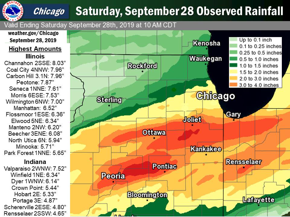 |
| Precipitation as measured by sensors and observers - for the 24 hour period ending 7 am Saturday September 28 |
...Morning Rainfall Roundup...

   The following are rain amounts for the previous 24-hours
   as measured in the morning by NWS Cooperative Observers
   and CoCoRaHS observers.
   Observations are usually taken between 6 AND 8 AM.

   24-hour rainfall amounts
       for Saturday(09/28/19)...


Illinois                                       Rain
  Location (County):                           fall (inches)

  Channahon 2SSE (Will)........................8.03
  Coal City 4NNW (Grundy)......................7.96
  Carbon Hill 3.1N (Grundy)....................7.96
  Peotone (Will)...............................7.87
  Seneca 1NNE (La Salle).......................7.61
  Morris 6ESE (Grundy).........................7.53
  Wilmington 6NW (Will)........................7.00
  Coal City 3N (Grundy)........................6.52
  Manhattan (Will).............................6.52
  Morris (Grundy)..............................6.51
  Flossmoor 1ESE (Cook)........................6.36
  Morris 2SSE (Grundy).........................6.36
  Elwood 5NE (Will)............................6.34
  Coal City (Grundy)...........................6.20
  Manteno 2NW (Kankakee).......................6.20
  Beecher 3ENE (Will)..........................6.08
  North Utica 6N (La Salle)....................5.94
  Manhattan 2SE (Will).........................5.93
  Flossmoor (Cook).............................5.91
  Manhattan 1ESE (Will)........................5.86
  Minooka (Grundy).............................5.71
  Park Forest 1NNE (Cook)......................5.65
  Channahon 1NNE (Will)........................5.55
  Marseilles Lock & Dam (La Salle).............5.55
  New Lenox 3ENE (Will)........................5.27
  Plainfield 5SW (Kendall).....................5.25
  Mokena 1W (Will).............................5.13
  Wilmington 3SE (Will)........................5.11
  New Lenox 3E (Will)..........................5.10
  New Lenox 2SE (Will).........................5.08
  Joliet 2n (Will).............................4.99
  Lockport 1SE (Will)..........................4.90
  Romeoville (Will)............................4.84
  Mazon 0.5ENE (Grundy)........................4.75
  Lansing (Cook)...............................4.72
  Park Forest (Cook)...........................4.70
  Homewood (Cook)..............................4.63
  Morris 5NNW (Grundy).........................4.62
  Beecher 3SSE (Will)..........................4.40
  Ottawa (La Salle)............................4.40
  Ottawa 1NW (La Salle)........................4.36
  Crete 3E (Will)..............................4.33
  Plainfield 3ESE (Will).......................4.31
  Ottawa 2N (La Salle).........................4.29
  Peru 1ENE (La Salle).........................4.13
  Brandon Road Lock & Dam (Will)...............4.10
  Joliet (Will)................................4.10
  Homer Glen 2NW (Will)........................4.04
  Homer Glen 1ENE (Will).......................4.02
  Monee (Will).................................4.00
  Streator 1WSW (La Salle).....................3.78
  St Anne (Kankakee)...........................3.73
  Dwight 4NNW (Grundy).........................3.72
  Pontiac 1SE (Livingston).....................3.66
  Midlothian 1SE (Cook)........................3.53
  La Salle (La Salle)..........................3.51
  Palos Park 1SW (Cook)........................3.43
  Dwight (Livingston)..........................3.40
  Watseka 6.9WNW (Iroquois)....................3.25
  Lemont (Cook)................................3.22
  Midway (Cook)................................3.18
  Plainfield (Will)............................3.13
  Oswego 5SSE (Kendall)........................3.12
  Park Ridge (Cook)............................3.07
  Earlville 3S (La Salle)......................3.01
  Herscher 3E (Kankakee).......................3.01
  Chebanse (Kankakee)..........................2.98
  Emington 2SSE (Livingston)...................2.94
  Oak Lawn (Cook)..............................2.89
  Bourbonnais (Kankakee).......................2.86
  Oak Lawn 2SE (Cook)..........................2.81
  Willow Springs (Cook)........................2.80
  Roselle 1ESE (Du Page).......................2.77
  Mendota (La Salle)...........................2.77
  Momence (Kankakee)...........................2.70
  Elk Grove Village 1ESE (Cook)................2.68
  Oak Lawn 1N (Cook)...........................2.62
  Midway Coop (Cook)...........................2.62
  Burr Ridge 1ESE (Cook).......................2.60
  Peru (La Salle)..............................2.60
  Chatsworth (Livingston)......................2.57
  Chicago Ridge (Cook).........................2.52
  Elk Grove Village 2WSW (Cook)................2.45
  Ohare Airport (Cook).........................2.45
  Countryside 1ENE (Cook)......................2.44
  Mendota (La Salle)...........................2.40
  Burr Ridge 2SW (Du Page).....................2.34
  Geneva 4WSW (Kane)...........................2.33
  Carol Stream (Du Page).......................2.31
  Rogers Park 2SW (Cook).......................2.30
  Cissna Park 1S (Iroquois)....................2.30
  Geneva 1SSW (Kane)...........................2.26
  Bridgeview 1NNW (Cook).......................2.24
  Paw Paw (Lee)................................2.24
  Chicago 6ESE (Cook)..........................2.18
  West Chicago (Du Page).......................2.17
  Lincolnwood 2E (Cook)........................2.17
  Batavia 2WNW (Kane)..........................2.17
  Somonauk 2NE (De Kalb).......................2.13
  Earlville 5NNE (De Kalb).....................2.09
  Bolingbrook 3NE (Du Page)....................2.07
  Ashkum 5.6E (Iroquois).......................2.07
  Naperville 4SSW (Will).......................2.07
  Sugar Grove 1ENE (Kane)......................2.04
  Sugar Grove 1NE (Kane).......................2.01
  Schaumburg 2E (Cook).........................1.99
  North Aurora 2NE (Kane)......................1.95
  Buckley (Iroquois)...........................1.92
  Gibson 3WNW (Ford)...........................1.91
  Aurora (Kane)................................1.90
  Gibson 6NE (Ford)............................1.89
  Batavia 1WSW (Kane)..........................1.89
  Batavia (Kane)...............................1.86
  Downers Grove 0.4NNE (Du Page)...............1.86
  Westmont (Du Page)...........................1.86
  Elburn (Kane)................................1.85
  Elburn (Kane)................................1.84
  Montgomery 1SSE (Kendall)....................1.84
  Elburn (Kane)................................1.84
  Elmhurst 1ESE (Du Page)......................1.82
  Elmhurst 2SE (Du Page).......................1.81
  Naperville 2SE (Du Page).....................1.81
  Glen Ellyn 2SSE (Du Page)....................1.80
  Plano (Kendall)..............................1.79
  Wheaton 2NNE (Du Page).......................1.75
  Glen Ellyn 1WSW (Du Page)....................1.75
  Elmhurst (Du Page)...........................1.75
  Elgin (Kane).................................1.74
  Elgin 1S (Kane)..............................1.74
  Lombard 1NNW (Du Page).......................1.72
  Paxton (Ford)................................1.72
  Aurora (Kane)................................1.70
  Downers Grove 1S (Du Page)...................1.70
  Lisle (Du Page)..............................1.68
  Hoffman Estates 2SE (Cook)...................1.65
  Aurora 4SE (Du Page).........................1.65
  Paxton (Ford)................................1.65
  Gibson 2SW (Ford)............................1.63
  La Grange Park 1SSW (Cook)...................1.61
  Lisle 1SW (Du Page)..........................1.61
  Naperville 1NW (Du Page).....................1.60
  Oak Park 1NNE (Cook).........................1.58
  Oak Park 1SW (Cook)..........................1.57
  Chicago 6NNE (Cook)..........................1.55
  Arlington Heights 1SW (Cook).................1.51
  Elgin 2W (Kane)..............................1.49
  Aurora 4SE (Du Page).........................1.47
  Glencoe (Cook)...............................1.42
  Mount Prospect 3NE (Cook)....................1.38
  Gilberts (Kane)..............................1.33
  Cicero 2SSW (Cook)...........................1.30
  Wheeling (Cook)..............................1.29
  Elgin 8WSW (Kane)............................1.28
  St. Charles 6NW (Kane).......................1.27
  Arlington Heights 1S (Cook)..................1.23
  De Kalb (De Kalb)............................1.19
  Palatine 1E (Cook)...........................1.18
  Barrington (Lake)............................1.16
  De Kalb (De Kalb)............................1.16
  Winnetka 1ESE (Cook).........................1.11
  Rochelle (Ogle)..............................1.10
  Elgin (Kane).................................1.09
  Waukegan (Lake)..............................1.07
  Steward (Lee)................................1.03
  De Kalb 1SW (De Kalb)........................1.00
  Bannockburn (Lake)...........................1.00
  Buffalo Grove 2N (Lake)......................0.99
  Highwood 1S (Lake)...........................0.95
  Lake Zurich (Lake)...........................0.91
  Ashton (Lee).................................0.90
  Cary (McHenry)...............................0.90
  Mundelein (Lake).............................0.86
  Lake Forest 2NNE (Lake)......................0.84
  Winthrop Harbor 1SSW (Lake)..................0.83
  Bull Valley 2WNW (McHenry)...................0.82
  Lake Villa 2WSW (Lake).......................0.80
  Zion (Lake)..................................0.79
  Lakemoor 2NW (McHenry).......................0.79
  Genoa (De Kalb)..............................0.76
  Rochelle (Ogle)..............................0.76
  Fox Lake 2SE (Lake)..........................0.75
  McHenry (Stratton Lock & Dam) (McHenry)......0.75
  Libertyville 2ESE (Lake).....................0.74
  Lincolnshire 1N (Lake).......................0.73
  Lake Bluff 1W (Lake).........................0.71
  Algonquin 1N (McHenry).......................0.70
  Wonder Lake 1WNW (McHenry)...................0.69
  Waukegan 2N (Lake)...........................0.67
  Crystal Lake 1WSW (McHenry)..................0.67
  Dixon 3NNW (Lee).............................0.66
  Woodstock 4SW (McHenry)......................0.66
  Lake Zurich 1N (Lake)........................0.56
  Woodstock 5nw (McHenry)......................0.53
  South Beloit 2SE (Winnebago).................0.41
  Rockford 2ENE (Winnebago)....................0.33
  Hebron (McHenry).............................0.31
  Capron (Boone)...............................0.26
  Rockford 3NE (Winnebago).....................0.25
  Rockford (Winnebago).........................0.24
  Roscoe 2ESE (Winnebago)......................0.20
  Roscoe 2se (Winnebago).......................0.20
  Kankakee (Kankakee)..........................0.03

Indiana                                        Rain
  Location (County):                           fall (inches)

  Valparaiso 2WNW (Porter).....................7.52
  Valparaiso 2NW (Porter)......................6.82
  Winfield 1NE (Lake)..........................6.34
  Valparaiso 1NNW (Porter).....................6.26
  Valparaiso 2N (Porter).......................6.19
  Dyer 1WNW (Lake).............................6.14
  Valparaiso 2WSW (Porter).....................5.75
  Crown Point (Lake)...........................5.44
  Crown Point 1N (Lake)........................5.44
  Hobart 2E (Lake).............................5.33
  Valparaiso 4SW (Porter)......................4.92
  Portage 3E (Porter)..........................4.87
  Schererville 2ESE (Lake).....................4.80
  Schererville 1E (Lake).......................4.80
  Hobart 1SSW (Lake)...........................4.68
  Rensselaer 2SSW (Jasper).....................4.65
  Valparaiso 6WSW (Porter).....................4.64
  Rensselaer (Jasper)..........................4.60
  Hebron 1NW (Porter)..........................4.46
  Valparaiso 6SSW (Porter).....................4.42
  Schererville 1E (Lake).......................4.27
  Munster 2NNW (Lake)..........................4.26
  Hebron 1NE (Porter)..........................4.26
  Rensselaer 4N (Jasper).......................4.24
  Valparaiso (Porter)..........................4.21
  Valparaiso 6NW (Porter)......................4.18
  Hebron 4NE (Porter)..........................4.07
  De Motte 6S (Jasper).........................3.90
  Lake Village (Newton)........................3.84
  Mount Ayr 2NNE (Newton)......................3.71
  Porter 1S (Porter)...........................3.46
  Morocco (Newton).............................3.44
  Hammond 1SSW (Lake)..........................3.43
  Rensselaer 5NW (Jasper)......................3.42
  Rensselaer 10NNE (Jasper)....................3.35
  Wheatfield 5W (Jasper).......................3.30
  Wheatfield 4WSW (Jasper).....................2.97
  De Motte 1SSW (Jasper).......................2.82
  Kentland 2SSE (Newton).......................2.75
  Remington (Jasper)...........................2.50
  De Motte 1NNW (Jasper).......................2.37
Additional Info
 |
Media use of NWS Web News Stories is encouraged! Please acknowledge the NWS as the source of any news information accessed from this site. Additional recaps can be found on the NWS Chicago Past Events Page |
|

