Extreme heat continues today from the central Plains to the lower Mississippi River Valley, over southeast Montana, and from southern California into the Southwest Deserts. Extreme Heat Warnings remain in effect. Severe thunderstorms capable of strong to severe wind gusts and large hail are possible across the Great Lakes into the Ohio Valley today into tonight. Read More >

NOAA All Hazards Weather Radio broadcasts National Weather Service warnings, watches, forecasts, and other hazard information 24 hours a day. Known as "the voice of National Weather Service," NOAA All Hazards Weather Radio is provided as a service by the Department of Commerce's National Oceanic and Atmospheric Administration (NOAA).
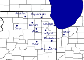
NWS Chicago NOAA All Hazards Weather Radio Programs:
|
|
Transmitter |
Frequency (MHz) |
Power (Watts) |
Counties in Coverage Area |
|
KWO-39 Chicago |
162.550 |
300 |
Cook, DuPage, Lake (IL), Lake (IN), Porter |
|
KZZ-81 Lockport |
162.425 |
1000 |
Cook, DuPage, Kane, Kankakee, Kendall, Lake (IL), Lake (IN), Will |
|
KZZ-57 Rockford |
162.475 |
1000 |
Boone, DeKalb, Green, Lee, Ogle, Rock, Stephenson, Winnebago |
|
WNG-536 DeKalb |
162.550 |
300 |
Boone, DeKalb, Kane, Lee, Ogle, Winnebago |
|
KZZ-55 Dixon |
162.525 |
300 |
Bureau, Carroll, Clinton (IA), Lee, Ogle, Whiteside |
|
WNG-689 Hebron |
162.450 |
300 |
Jasper, Lake (IN), LaPorte, Newton, Porter, Pulaski, Starke |
|
KXI-41 Crystal Lake |
162.500 |
300 |
Boone, Cook, Kane, Kenosha, Lake, McHenry, Walworth |
|
KXI-58 Plano |
162.400 |
300 |
DeKalb, DuPage, Grundy, Kane, Kendall, LaSalle, Will |
|
WXK-24 Odell |
162.450 |
1000 |
Ford, Grundy, Iroquois, Kankakee, LaSalle, Livingston, Marshall, McLean, Will, Woodford |
|
KXI-86 Crescent City |
162.500 |
300 |
Benton, Ford, Iroquois, Kankakee, Newton, Vermilion |
|
KZZ-58 Kankakee |
162.525 |
300 |
Iroquois, Kankakee, Lake, Newton, Will |
Other NOAA All Hazards Weather Radio Items of Interest:


 ;
;