Lubbock, TX
Weather Forecast Office
Quick Shot of Chilly Rain
|
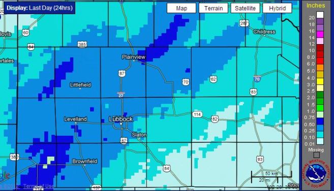 |
| 24-hour radar estimated rainfall ending at 9 am on Monday, 31 December 2012. Click on the image for a larger view. A regional view of the radar estimated rainfall for this same period can be FOUND HERE. |
|
A quick moving storm system combined with increasing moisture and temperatures in the 30s to bring a chilly rain to much of the South Plains region to close out 2012. The precipitation fell during the late evening hours of the 30th (Sunday) and early morning hours of the 31st (Monday). As the above and below maps show, nearly everyone experienced a little precipitation. The heaviest rain, from 1/3 to over 1/2 of an inch, fell in a southwest to northeast swath across the South Plains. In addition, the temperature did fall to or just below the freezing mark across parts of the western South Plains into the southwest Texas Panhandle. These cold temperatures allowed a little freezing rain, sleet and snow to develop, though accumulations were very light and resulted in minimal travel difficulties. |
|
|
|||
|
Rainfall totals from the end of the year cold rain event. Reports are courtesy of the West Texas Mesonet.
|

US Dept of Commerce
National Oceanic and Atmospheric Administration
National Weather Service
Lubbock, TX
2579 S. Loop 289
Suite 100
Lubbock, TX 79423-1400
806-745-3916
Comments? Questions? Please Contact Us.


 Follow us on X
 Follow us on Facebook
 Follow us on YouTube
 LUB RSS Feed


