| Rolling Plains and Southern South Plains Winter Storm 5-6 December 2013 |
|||
 |
|||
|
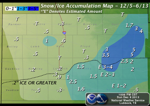
Storm total snow, sleet, and ice accumulations for December 5th-6th, 2013
|
|||
| A strong cold front plowed through the Extreme Southern Texas Panhandle, South Plains, and Rolling Plains on December 4th (Wednesday), plummeting temperatures into the 20s overnight and beginning a three and a half day period of subfreezing temperatures in West Texas. | |||
 |
|||
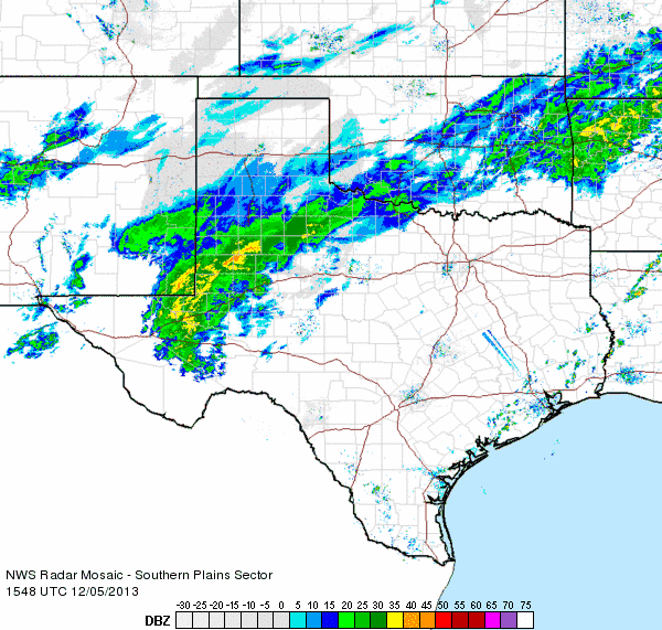
| Regional radar animation valid from 9:48 to 10:58 am on Thursday, 5 December 2013. | |||
|
The first batch of wintry precipitation fell on the extreme Southern Texas Panhandle, South Plains, and Rolling Plains as an upper level disturbance moved through ahead of a parent trough during the early morning hours of the 5th (Thursday), consisting of mainly freezing rain and sleet. A large swath of freezing rain impacted locations in the southern South Plains into the southern and central Rolling Plains, with amounts up to one quarter of an inch reported. Portions of King and Cottle Counties observed up to two and a half inches of sleet and snow combined. Nearly 100 traffic accidents were attributed to icy roads in and around Lubbock, while icy conditions on Texas Highway 114, one mile west of Smyer in Hockley County, contributed to a two-vehicle crash producing one fatality and two injuries. |
|||
 |
|||
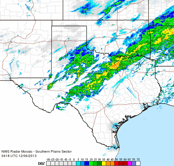
| Regional radar animation valid from 10:18 to 11:28 pm on Thursday, 5 December 2013. | |||
|
As the upper trough pushed out of the Great Basin and into the Desert Southwest, another round of frozen precipitation impacted the southern South Plains and Rolling Plains into the far southeastern Panhandle throughout the evening on the 5th (Wednesday) into the morning of the 6th (Thursday). The precipitation consisted mostly of sleet early before transitioning to snow as cooling occurred aloft throughout the atmosphere. Up to five inches of storm total snow and sleet occurred in Paducah, with portions of Childress and Motley Counties reporting three and a half to four inches. Below are a few pictures captured during the wintry weather on the South Plains. |
|||
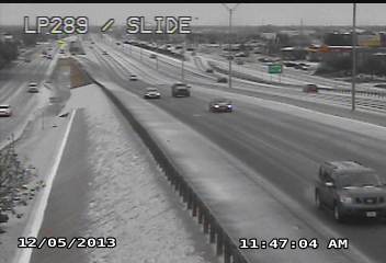
Pictures from Lubbock (left) and Shallowater (right) on 5 December 2013. The sleet and ice created some travel problems. The pictures are courtesy of TXDOT (left) and KAMC (right).
|
|||

