
Dangerous heat will expand from the Gulf Coast into the Southern Plains and Desert Southwest through week's end. Additional extreme heat impacting the Pacific Northwest will shift to the northern Plains by the weekend. Tropical Storm Bertha is expected to continue to impact portions of the northern Gulf Coast from the western Florida Panhandle to southeastern Louisiana through tonight. Read More >
| Severe Thunderstorm bring lots of Wind and a little Rain 8-9 March 2019 |
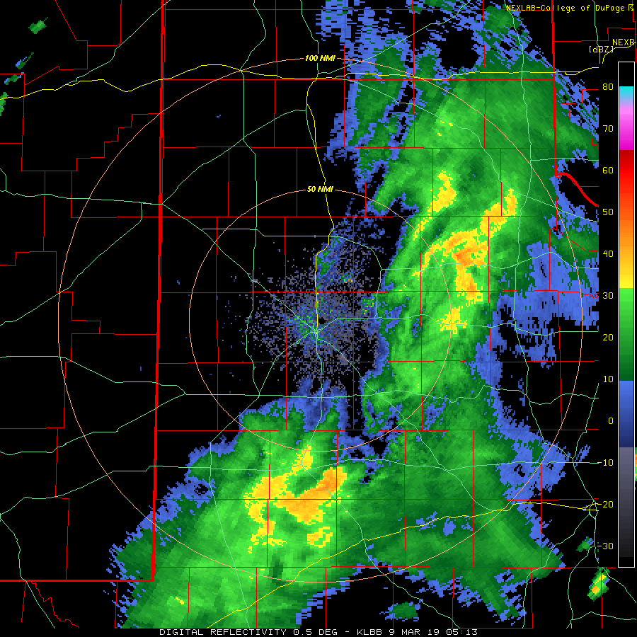 |
| Lubbock radar animation valid from 11:13 pm on Friday, 8 March, to 7:04 am on Saturday, 9 March 2019. |
| A powerful upper level storm system brought a little bit of rainfall and an excess of wind to the South Plains Friday night into Saturday morning (8-9 March). This system was moisture-starved, which allowed evaporation of the rainfall to enhance the winds, while limiting the rainfall. An initial band of showers developed across the South Plains and Rolling Plains Friday evening. Rain totals with this activity were very light, from a trace to a few hundredths, but the showers did provide many strong wind gusts and a couple of severe gusts. |
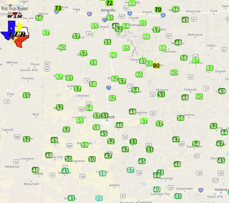 |
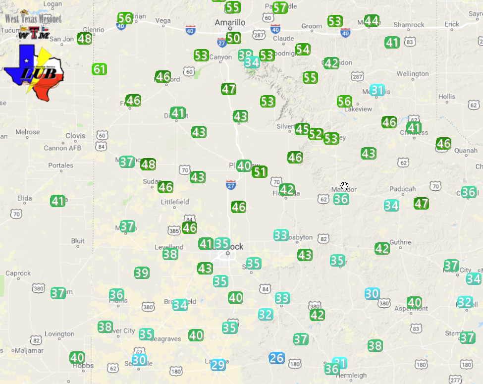
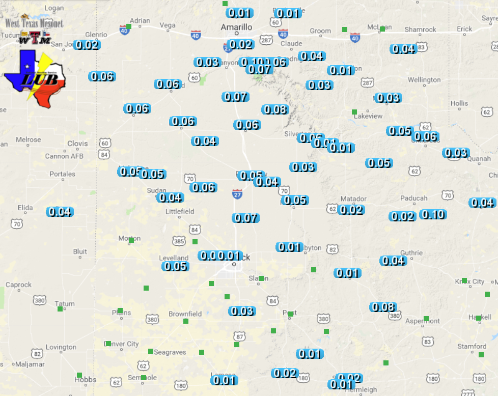
| Maximum wind gusts measured by the West Texas Mesonet on 9 March 2019. The maximum sustained wind speeds can be VIEWED HERE. |
| Not to be outdone, a narrow band of showers and thunderstorms developed in eastern New Mexico late Friday evening and then raced across the Texas Panhandle and central and northern South Plains early Saturday morning. This activity generated very strong winds, with gusts of 55 to 65 mph being common. The Turkey West Texas Mesonet recorded a rogue 80 mph wind gust at 2:45 am. |
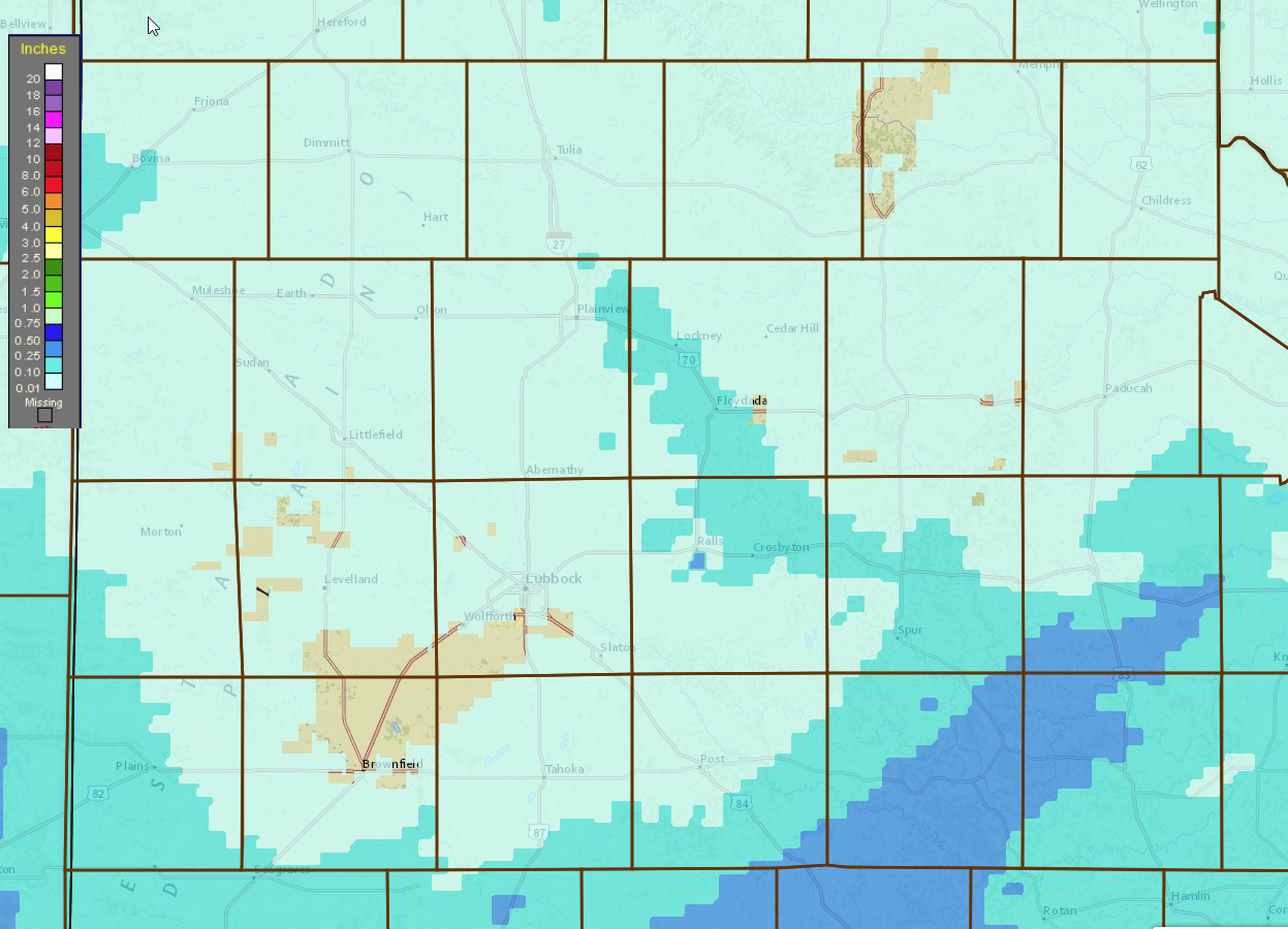 |
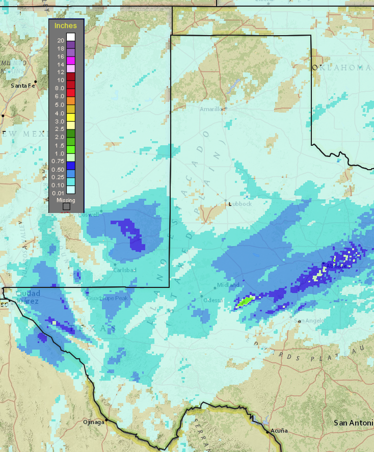
| 48-hour radar-estimated and bias-corrected rainfall ending at 1 pm on 10 March 2019. A regional view of this same information can be FOUND HERE. Observed rain totals from the West Texas Mesonet can also be VIEWED HERE. |
| Unfortunately, the rain totals were on the light side, from a trace to a tenth of an inch. These light totals, combined with the strong and dusty winds, only managed to dirty exposed vehicles before drying back up. Gusty westerly winds continued behind the narrow band of showers and thunderstorms into the day on Saturday before gradually weakening during the afternoon hours. |
| The Preliminary Storm Reports for this first round of severe thunderstorms in 2019 are available below. |
PRELIMINARY LOCAL STORM REPORT...SUMMARY
NATIONAL WEATHER SERVICE LUBBOCK TX
631 AM CST SAT MAR 09 2019

..TIME...   ...EVENT...      ...CITY LOCATION...     ...LAT.LON...
..DATE...   ....MAG....      ..COUNTY LOCATION..ST.. ...SOURCE....
            ..REMARKS..

0635 PM     NON-TSTM WND GST 2 S BROWNFIELD          33.15N 102.27W
03/08/2019  M59 MPH          TERRY              TX   MESONET

0839 PM     NON-TSTM WND GST 9 WSW EARTH             34.19N 102.56W
03/08/2019  M58 MPH          LAMB               TX   MESONET

1255 AM     TSTM WND GST     2 NE FRIONA             34.65N 102.69W
03/09/2019  M60 MPH          PARMER             TX   MESONET

            MEASURED BY WEST TEXAS MESONET.

0110 AM     TSTM WND GST     2 SSW MULESHOE          34.21N 102.74W
03/09/2019  M67 MPH          BAILEY             TX   MESONET

            MEASURED BY WEST TEXAS MESONET.

0120 AM     TSTM WND GST     9 WSW EARTH             34.19N 102.56W
03/09/2019  M61 MPH          LAMB               TX   MESONET

            MEASURED BY WEST TEXAS MESONET.

0140 AM     TSTM WND GST     3 N HART                34.42N 102.11W
03/09/2019  M59 MPH          CASTRO             TX   MESONET

            MEASURED BY WEST TEXAS MESONET.

0150 AM     TSTM WND GST     6 S OLTON               34.09N 102.12W
03/09/2019  M58 MPH          LAMB               TX   MESONET

            MEASURED BY WEST TEXAS MESONET.

0155 AM     TSTM WND GST     2 ENE TULIA             34.54N 101.74W
03/09/2019  M66 MPH          SWISHER            TX   MESONET

            WEST TEXAS MESONET

0204 AM     TSTM WND GST     VIGO PARK               34.65N 101.50W
03/09/2019  M65 MPH          SWISHER            TX   MESONET

            ALSO GUSTED TO 60 MPH AT 205 AM. MEASURED BY WEST TEXAS
            MESONET.

0210 AM     TSTM WND GST     4 S LEVELLAND           33.53N 102.36W
03/09/2019  M65 MPH          HOCKLEY            TX   MESONET

            WEST TEXAS MESONET.

0210 AM     TSTM WND GST     1 S PLAINVIEW           34.18N 101.71W
03/09/2019  M62 MPH          HALE               TX   MESONET

            WEST TEXAS MESONET

0215 AM     TSTM WND GST     1 S PLAINVIEW           34.16N 101.72W
03/09/2019  M62 MPH          HALE               TX   AWOS

0215 AM     TSTM WND GST     6 SSW ANTON             33.73N 102.19W
03/09/2019  M64 MPH          HOCKLEY            TX   MESONET

            WEST TEXAS MESONET

0225 AM     TSTM WND GST     7 ESE SILVERTON         34.45N 101.19W
03/09/2019  M61 MPH          BRISCOE            TX   MESONET

            WEST TEXAS MESONET

0229 AM     TSTM WND GST     3 ENE SOUTH PLAINS      34.24N 101.26W
03/09/2019  M60 MPH          FLOYD              TX   MESONET

            WEST TEXAS MESONET

0230 AM     TSTM WND GST     5 ENE ABERNATHY         33.88N 101.76W
03/09/2019  M62 MPH          HALE               TX   MESONET

            WEST TEXAS MESONET

0230 AM     TSTM WND GST     7 ESE SILVERTON         34.45N 101.19W
03/09/2019  M59 MPH          BRISCOE            TX   MESONET

            WEST TEXAS MESONET

0233 AM     TSTM WND GST     6 NNE LUBBOCK           33.67N 101.82W
03/09/2019  M59 MPH          LUBBOCK            TX   ASOS

0235 AM     TSTM WND GST     CAPROCK CANYON SP       34.41N 101.06W
03/09/2019  M63 MPH          BRISCOE            TX   MESONET

            WEST TEXAS MESONET

0235 AM     TSTM WND GST     2 S BROWNFIELD          33.15N 102.27W
03/09/2019  M59 MPH          TERRY              TX   MESONET

            WEST TEXAS MESONET

0240 AM     TSTM WND GST     6 SSW WOLFFORTH         33.42N 102.05W
03/09/2019  M58 MPH          LUBBOCK            TX   MESONET

            WEST TEXAS MESONET

0241 AM     TSTM WND GST     2 S LESLEY              34.65N 100.81W
03/09/2019  M66 MPH          HALL               TX   MESONET

            GUSTS OF 60 TO 66 MPH FROM 241 AM TO 245 AM. MEASURED
            BY WEST TEXAS MESONET.

0245 AM     TSTM WND GST     2 WSW TURKEY            34.38N 100.93W
03/09/2019  M80 MPH          HALL               TX   MESONET

            SUSTAINED 53 MPH. MEASURED BY WEST TEXAS MESONET.

0305 AM     TSTM WND GST     1 S NORTHFIELD          34.27N 100.60W
03/09/2019  M60 MPH          MOTLEY             TX   MESONET

            WEST TEXAS MESONET

0316 AM     TSTM WND GST     2 W CHILDRESS           34.43N 100.28W
03/09/2019  M71 MPH          CHILDRESS          TX   ASOS

0320 AM     TSTM WND GST     6 NW WHITE RIVER LAKE   33.53N 101.17W
03/09/2019  M59 MPH          CROSBY             TX   MESONET

            WEST TEXAS MESONET

0320 AM     TSTM WND GST     2 NNE CHILDRESS         34.46N 100.20W
03/09/2019  M60 MPH          CHILDRESS          TX   MESONET

            WEST TEXAS MESONET

0325 AM     TSTM WND GST     6 NW WHITE RIVER LAKE   33.53N 101.17W
03/09/2019  M67 MPH          CROSBY             TX   MESONET

            WEST TEXAS MESONET

0344 AM     TSTM WND GST     2 SSE HACKBERRY         33.90N 100.13W
03/09/2019  M60 MPH          COTTLE             TX   MESONET

            WEST TEXAS MESONET


&&

EVENT NUMBER LUB1900086 LUB1900087 LUB1900088 LUB1900089 LUB1900090
LUB1900091 LUB1900092 LUB1900093 LUB1900094 LUB1900095 LUB1900096
LUB1900097 LUB1900098 LUB1900099 LUB1900106 LUB1900100 LUB1900101
LUB1900103 LUB1900102 LUB1900104 LUB1900105 LUB1900108 LUB1900107
LUB1900109 LUB1900110 LUB1900111 LUB1900112 LUB1900113 LUB1900114


Shortly before 1 AM CST, a squall line raced east across the far
southern Panhandle and northern South Plains at speeds up to 60 mph,
with isolated to scattered showers and storms farther south. Numerous
severe wind gusts of 58 mph or more accompanied these storms, with a
peak gust to 80 mph measured at a West Texas mesonet station near
Turkey.

$$

