
Scattered thunderstorms with severe gusts, hail and a tornado risk are possible near a cold front from the Ohio Valley to the Mid-Atlantic tonight. Tropical Storm Bertha is expected to bring tropical storm conditions to portions of the Gulf Coast from the panhandle of Florida into Louisiana through Wednesday. Read More >
|
Winter storm wallops West Texas |
|
 |
|
|
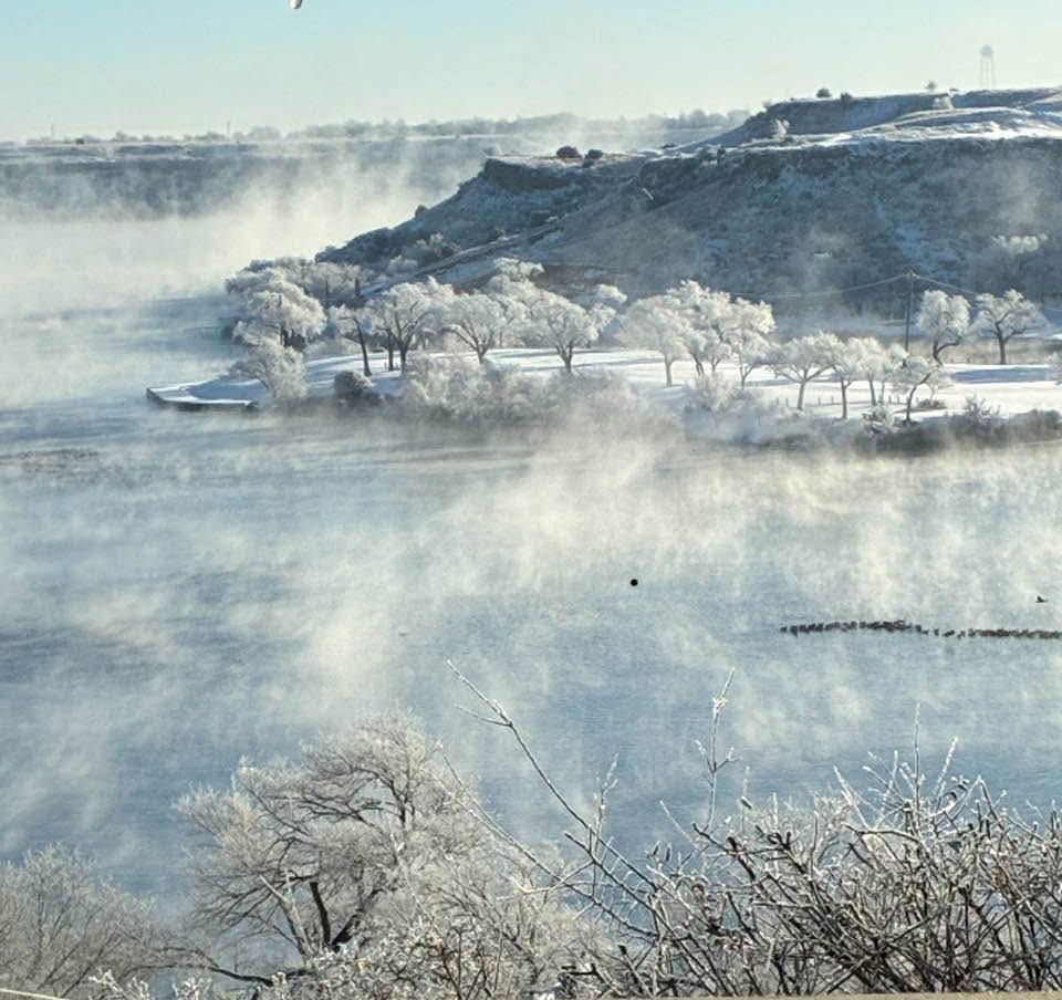
Steamy wintry scene from Buffalo Springs on Monday (26 January 2026). The image is courtesy of Linda Honeycutt via KCBD. |
|
|
The ongoing mild to warm and persistently dry winter of 2025-2026 made an abrupt one-eighty in late January 2026. The abrasive change was fueled by the passage of an Arctic cold front, in conjunction with several disturbances passing over aloft which was able to tap abundant low-level moisture from the Gulf. The result was high temperatures plunging from near and above average (in the 50s and lower 60s) to the single digits and lower teens, along with a prolonged period of wintry weather. |
|
 |
|
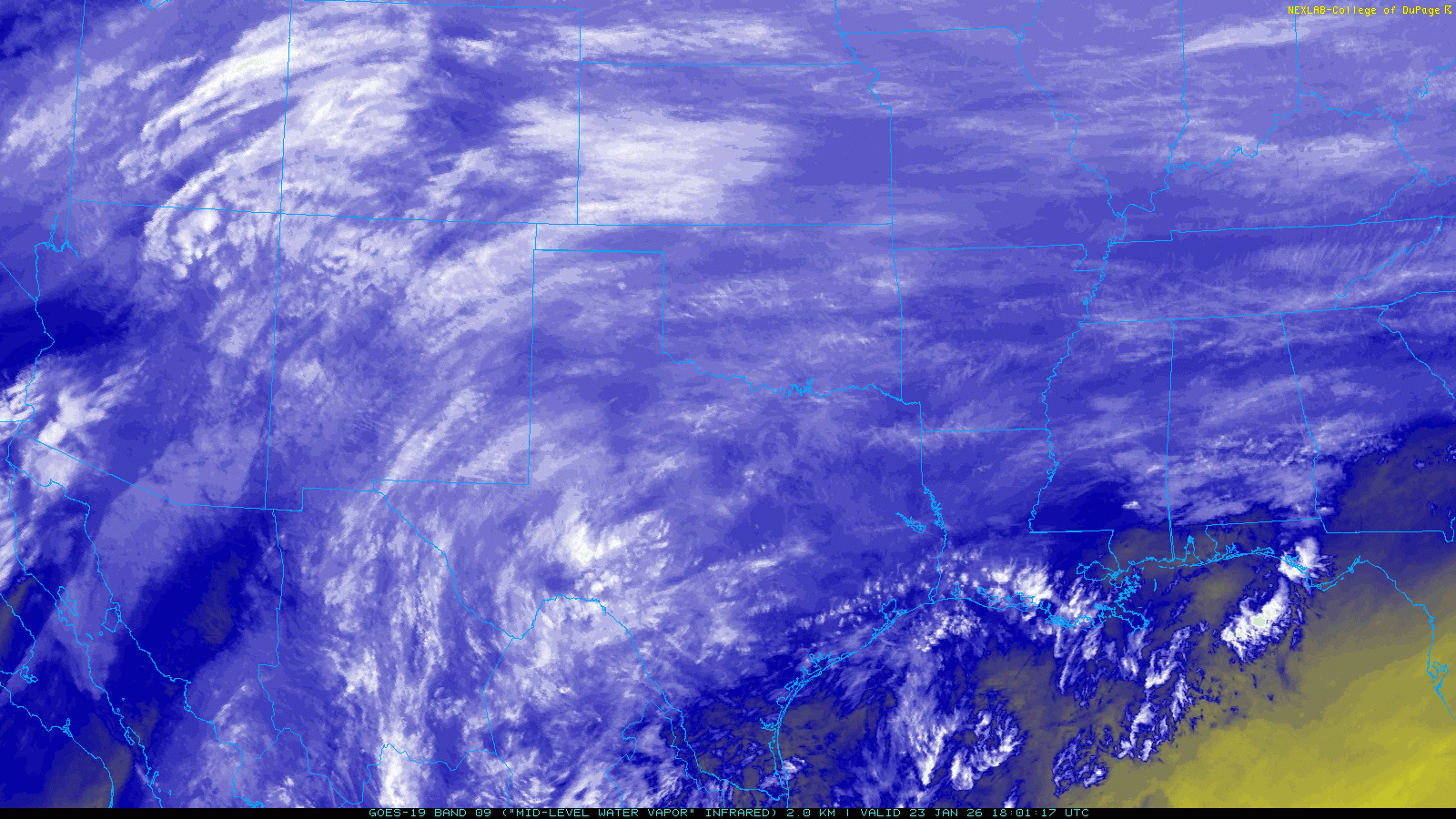
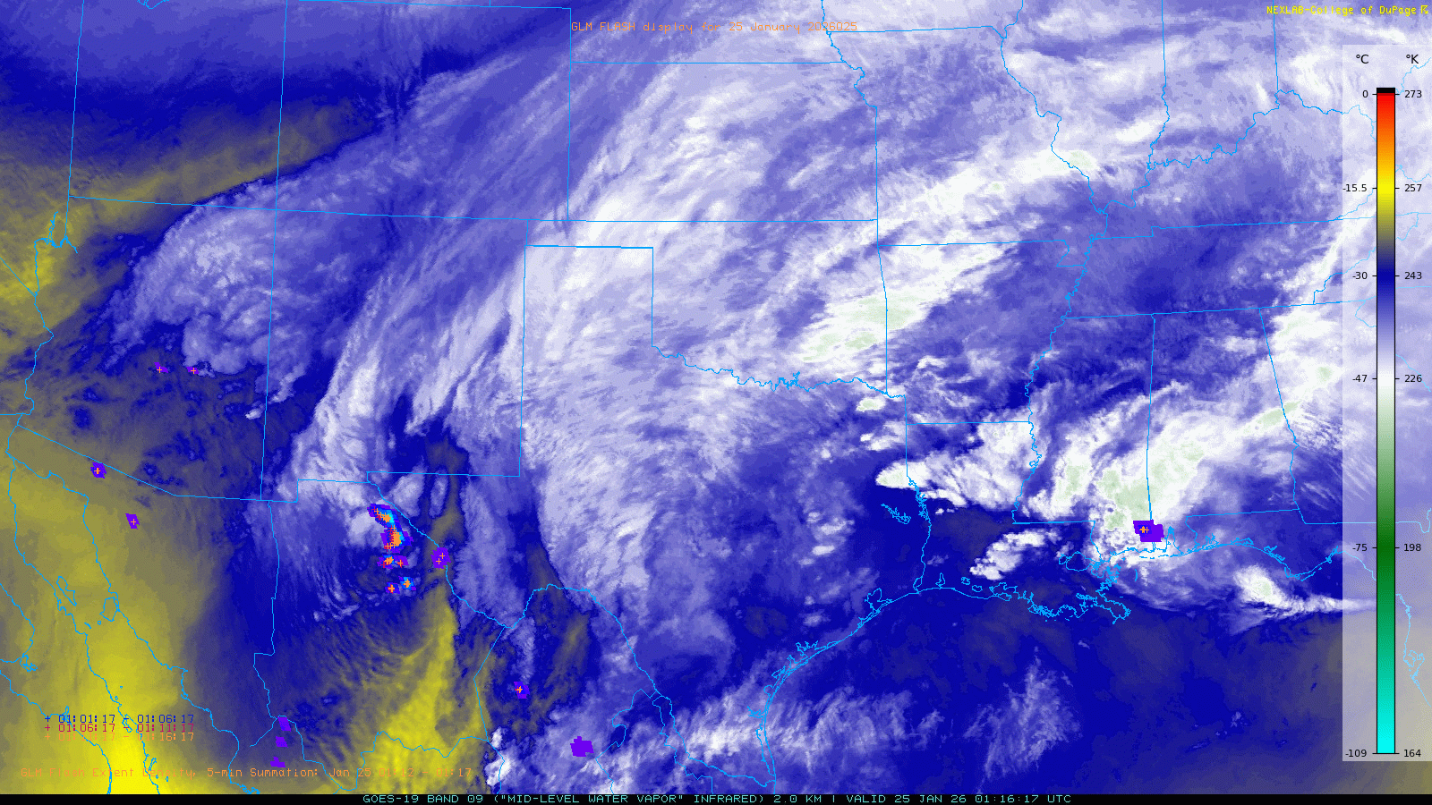
| Water vapor satellite animation from 1:01 pm on Friday to 12:01 pm on Sunday (23-26 January 2026). A more detailed water vapor image, captured during a period of heavier precipitation from 7:16 pm to 9:06 pm on Saturday (25 January), can be VIEWED HERE. | |
|
The dramatic changes kicked off on Friday (23 January) as an Arctic cold front advanced through the South Plains region throughout the day. In advance of the front, mild temperatures, from the middle 30s to the lower 40s, and areas of fog and drizzle were in place around daybreak. This turned out to be the warmest part of the day as gusty northeasterly winds carried increasingly cold air southwestward in the region during the day. In Lubbock, the temperature dropped below freezing around midday, and remained sub-freezing until just after noon the following Tuesday, resulting in almost four continuous days (95 hours and 35 minutes to be exact) at or below freezing! |
|
 |
|
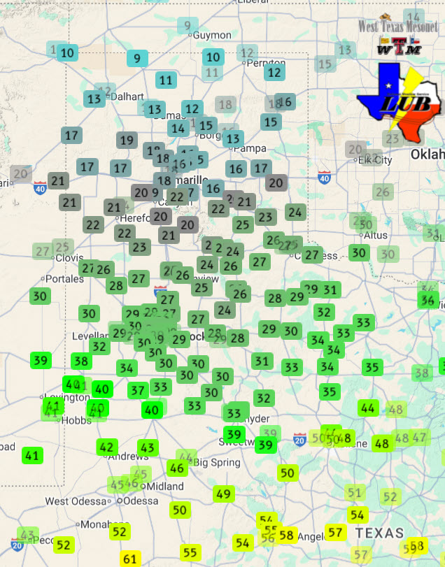
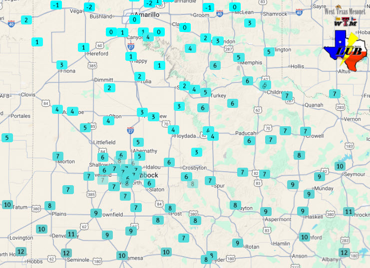
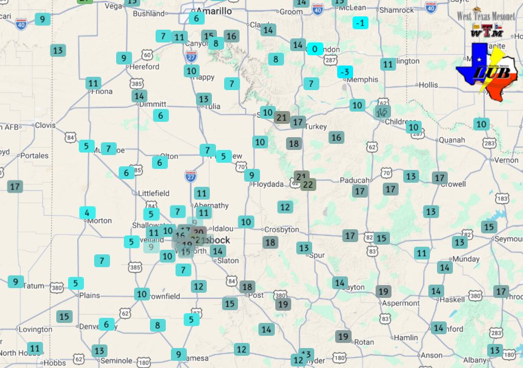
| Temperatures observed by the West Texas Mesonet (WTM) at 1:50 pm on Friday (23 January 2026). | |
|
The above map illustrates the magnitude of the temperature gradient, with temperatures early Friday afternoon ranging from the single digits and teens across the northern Texas Panhandle to the 50s and lower 60s in the Concho Valley and Edwards Plateau. In addition to being bitterly cold, the Arctic air was initially quite dry, quickly scouring out any residual fog and drizzle. However, shortly after the cold air infiltrated the region, Pacific moisture began to stream over from the southwest resulting in the onset of wintry showers. The first moisture fell as freezing rain at many locations, but quickly switched to sleet as the lower levels of the atmosphere cooled. |
|
 |
|
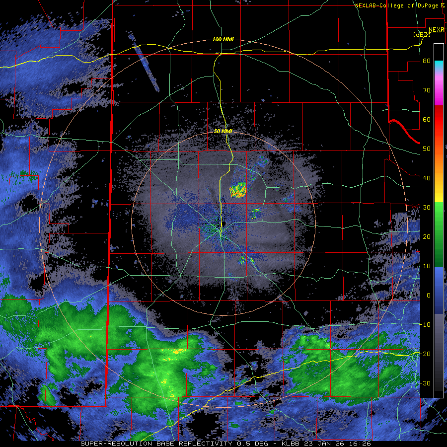
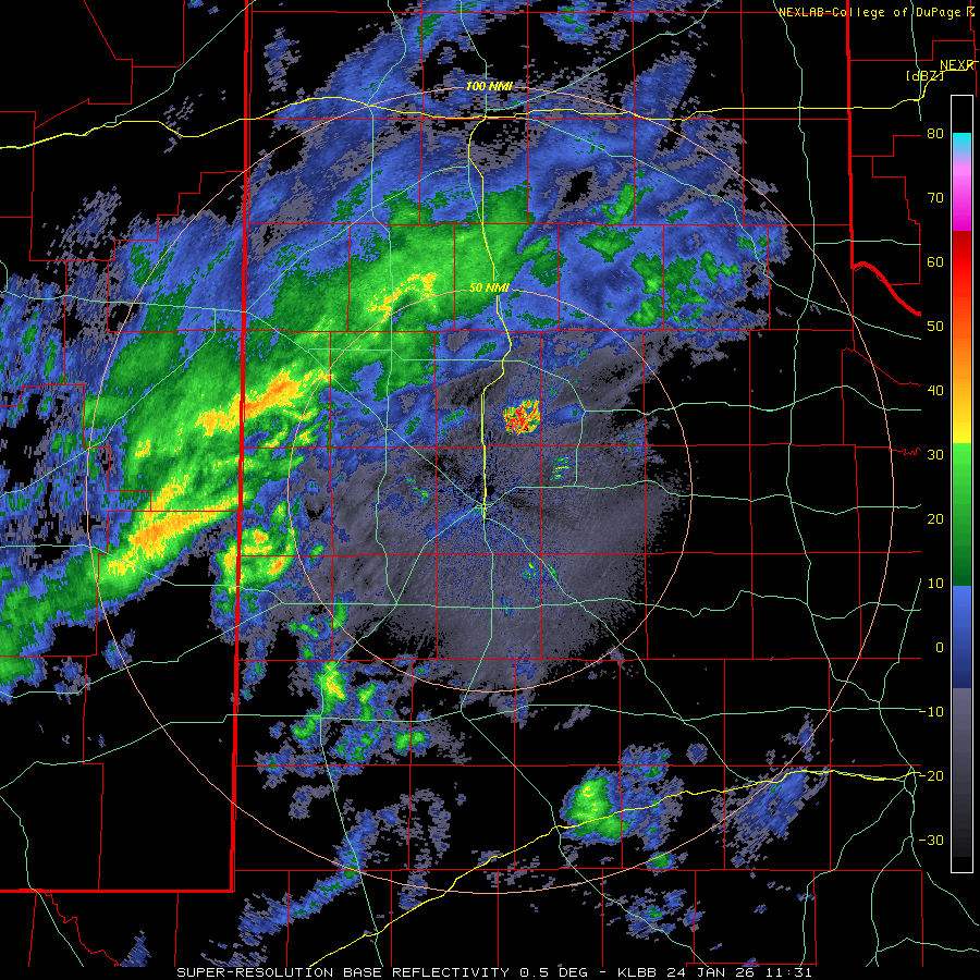
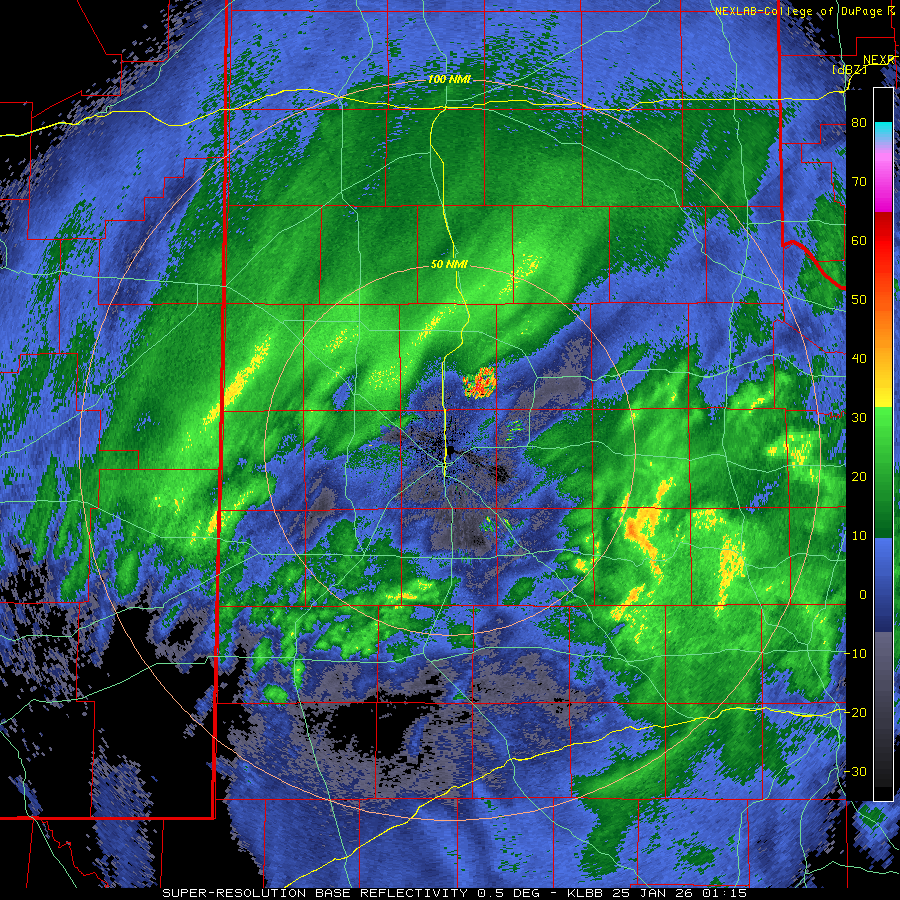
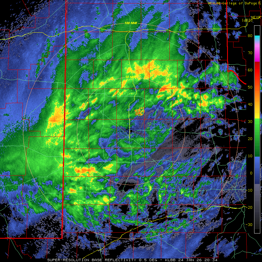
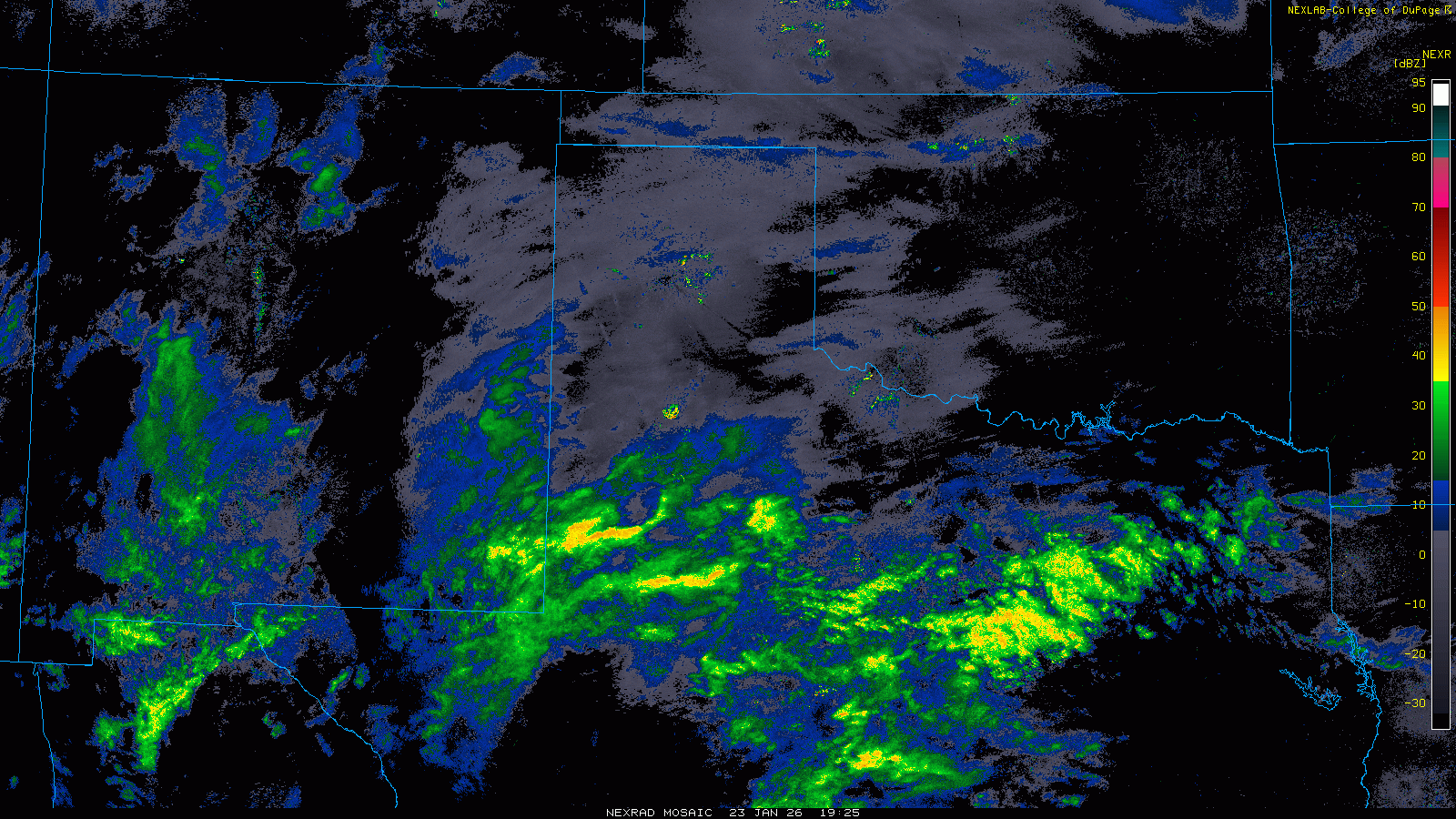
| Lubbock WSR-88D radar animation valid from 10:26 am to 7:12 pm on Friday (26 January 2026). | |
|
Despite temperatures tumbling well below freezing, into the single digits for most by Saturday morning, sleet continued to be the predominate mode of precipitation when the heavier showers moved overhead Friday night into Saturday. The culprit for the wintry mix was a stubborn "warm" layer about a mile above the ground where temperatures persisted above freezing, as high as 40 degrees or so. This "warm" layer aloft caused the snowflakes falling into it to partially or fully melt, depending on how warm and deep the above freezing layer was. Oftentimes this would result in freezing rain at ground level, but in this case the bitterly cold air below the "warm" layer was deep enough and cold enough for the rain drop or partially melted snowflake to completely refreeze, becoming sleet before hitting the ground. |
|
 |
 |
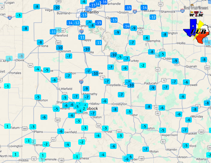
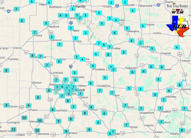
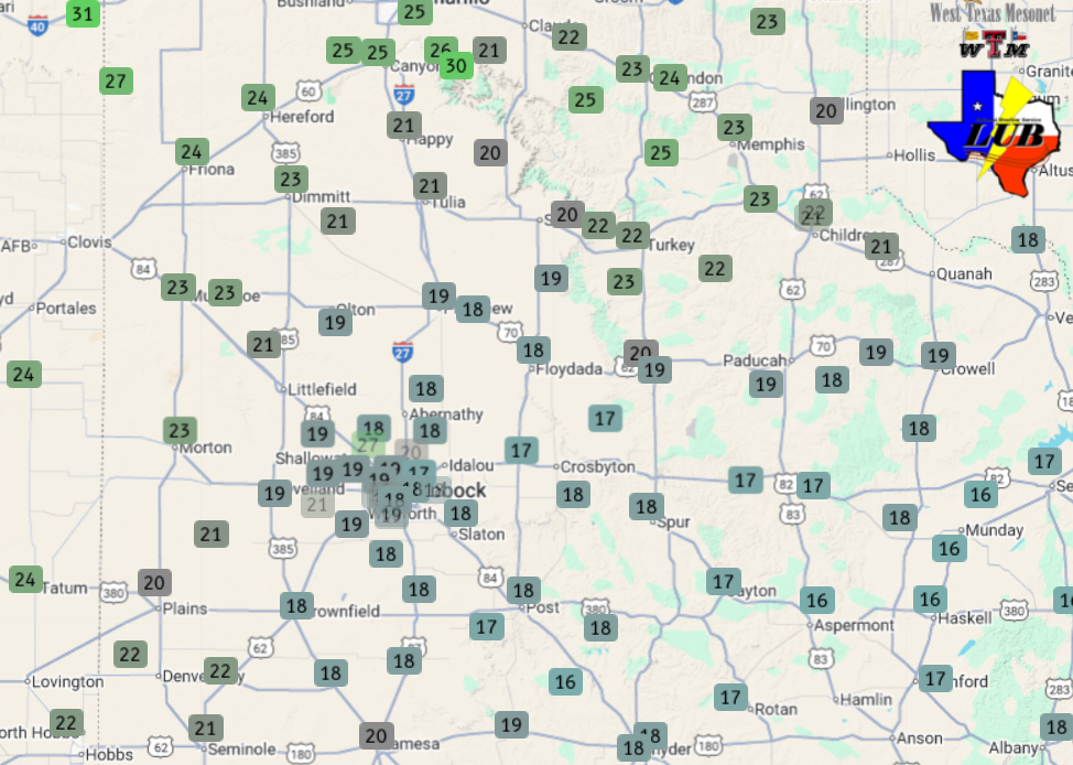
| Saturday morning's lows (left) and Saturday afternoon's highs (right) measured by the West Texas Mesonet (24 January 2026). | |
|
Even though temperatures moved very little during the day Saturday, with highs only reaching the upper single digits to lower and middle teens, the warmth aloft kept periods of sleet showers going much of the day. Since sleet accumulates much more slowly than snow (with the same amount of liquid equivalent), totals were on the lighter side, ranging from a few tenths up to an inch or two in most spots. Regardless, roads quickly became slick and remained so as ice and sleet covered the roadways Friday evening and did not improve any on Saturday. |
|
 |
|
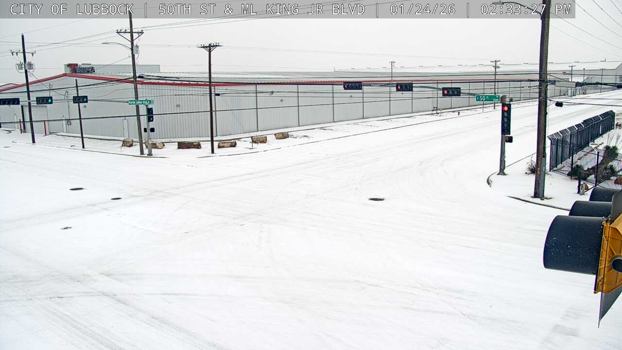
| Snowy intersection at 50th Street and Martin Luther King Junior Boulevard in Lubbock on Saturday afternoon (24 January 2026). The image is courtesy of the City of Lubbock. | |
|
Not to be overlooked, in addition to the wintry precipitation and difficult travel conditions, breezy winds combined with the bitter cold temperatures to produce dangerous wind chills. To exposed skin, it felt like 0 to -15 degrees, even worse at times, throughout the day on Saturday. |
|
 |
 |
| Wind chill values, as measured by the West Texas Mesonet, at 5:10 am (left) and 2 pm (right) on Saturday (24 January 2026). | |
|
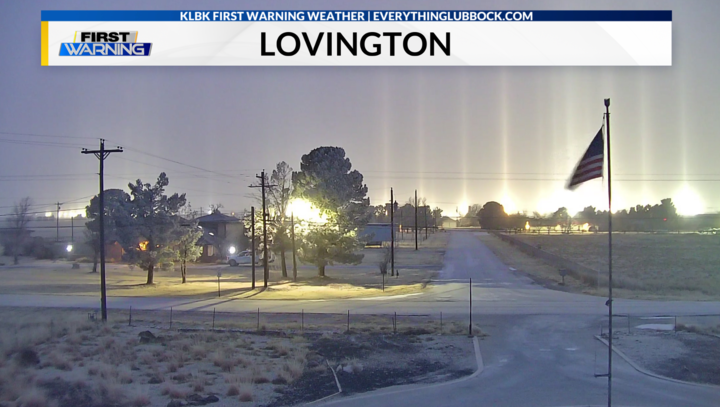
The cold air and relatively moist conditions created interesting optical effects, including light pillars. As the name implies and the picture below illustrates, light pillars look like a vertical beam of light which are created when light from a point source is reflected by numerous ting, flat hexagon-shaped ice crystals suspended in the lower atmosphere. These types of crystals are favored in cold and moist condition not often experienced this far south. |
|
 |
|
| Light pillars, a rare optical effect seen this far south, observed in Lovington, NM, early Saturday morning (24 January 2026). The picture is courtesy of KLBK. | |
|
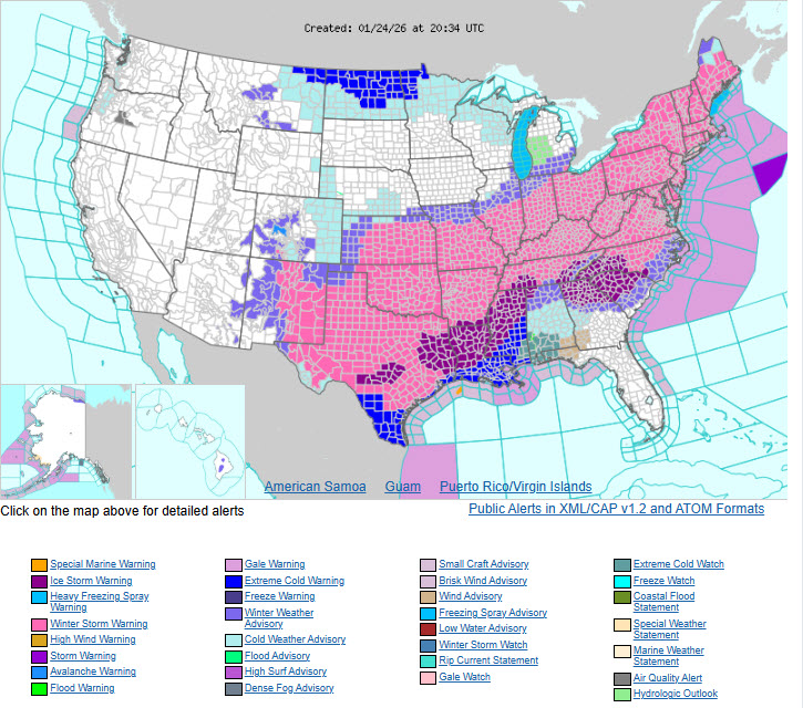
The cold air and winter storm and was not confined to West Texas or even the southern High Plains, but affected a large portion of the Lower 48, as the below graph shows. Heavy snow, sleet and/or freezing rain resulted in major impacts from New Mexico to New England. Even where wintry precipitation didn't fall, exceptionally cold air affected the Midwest and Great Lakes. |
|
 |
|
| Graphic showing the extent of winter weather related advisories, watches and warnings on Saturday afternoon (24 January 2026). | |
|
Eventually, late Saturday afternoon into Saturday evening, the "warm" layer aloft dropped below freezing which allowed the sleet/snow mix to change over to exclusively snow. This coincided with a stronger round of lift associated with a storm system approaching from the Desert Southwest. The net result was more widespread moderate to heavy snow, including some huge snowflakes falling as the switchover from sleet to snow occurred. |
|
 |
|
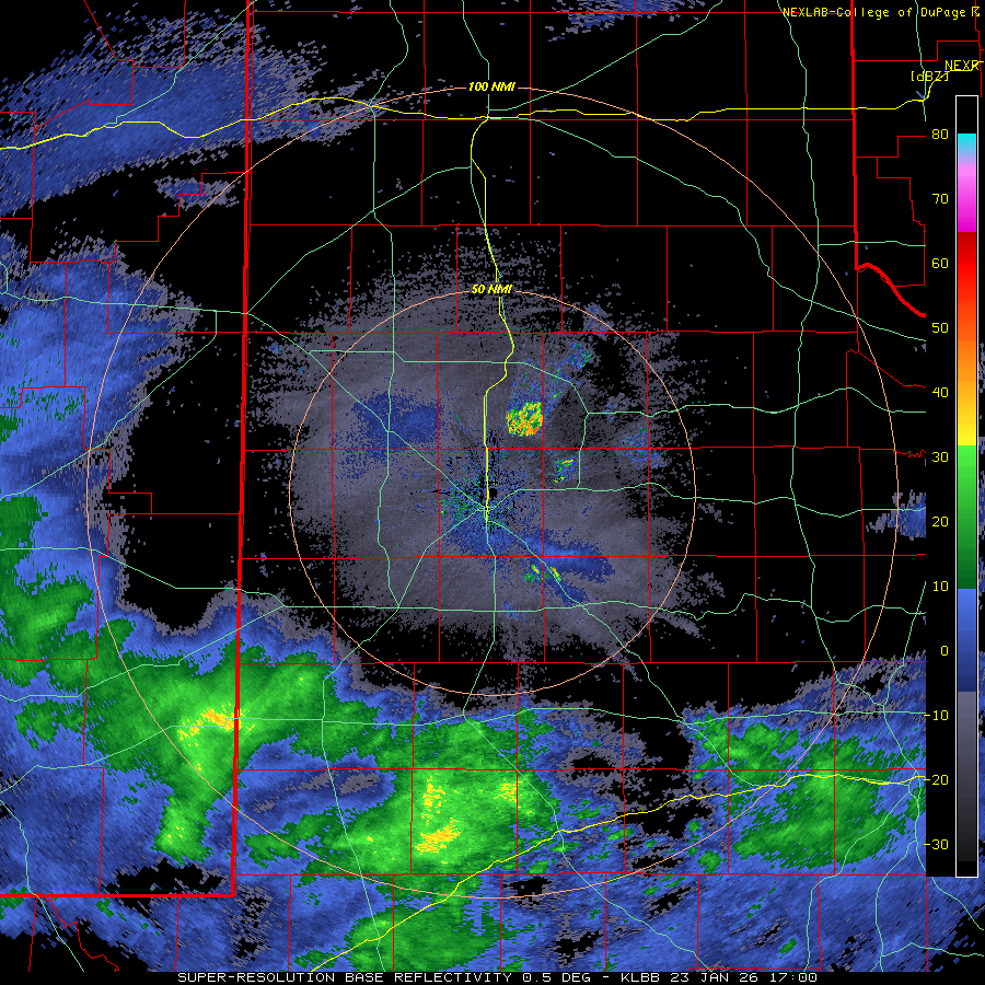
| Lubbock WSR-88D radar animation valid from 5:31 am to 2:29 pm on Saturday (24 January 2026). An additional radar animation, valid from 2:30 pm to 7:04 pm on Saturday (24 January), can be FOUND HERE. | |
|
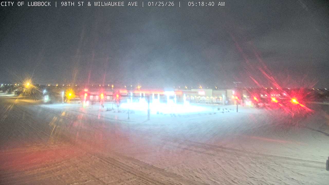
Snow quickly piled up on top of the layers of ice and sleet already in place Saturday night into early Sunday. The most persistent bands of heavy snow targeted the western South Plains and the south-central Texas Panhandle, though the entire region saw some snowfall. |
|
 |
|
| Snow coming down and accumulating at 98th Street and Milwaukee Avenue in Lubbock at 5:18 am on Sunday (25 January 2026). The image is courtesy of the City of Lubbock. | |
|
Temperatures remained bitterly cold into Sunday morning with lows in the single digits. Combined with a breeze, wind chills well below zero were common. |
|
 |
 |
| Sunday morning's lows (left) and Sunday afternoon's highs (right) measured by the West Texas Mesonet (25 January 2026). | |
|
Temperatures finally moderated Sunday afternoon, though still only "warmed" into the upper teens and lower 20s at most spots. Where sunshine returned by mid-afternoon, and they received the least amount of wintry precipitation, highs did reach the middle 20s over the southwest Texas Panhandle. |
|
 |
|
| Lubbock WSR-88D radar animation valid from 7:15 pm on Saturday to 4:06 am on Sunday (24-25 January 2026). An additional radar animation, valid from 11 am on Friday to 5:09 am on Saturday (23-24 January), can be FOUND HERE. | |
|
A final upper level disturbance emerging from the southern Rockies brought the last wave of light to moderate snow to parts of the region on Sunday. This snowfall was less widespread, and the system didn't have a lot of moisture to work with, but it produced a very light and fluffy snow which accumulated quickly where the more intense bands moved through. This last burst of snow targeted the central South Plains and Rolling Plains providing another quick 1 to 2+ inches for many. |
|
 |
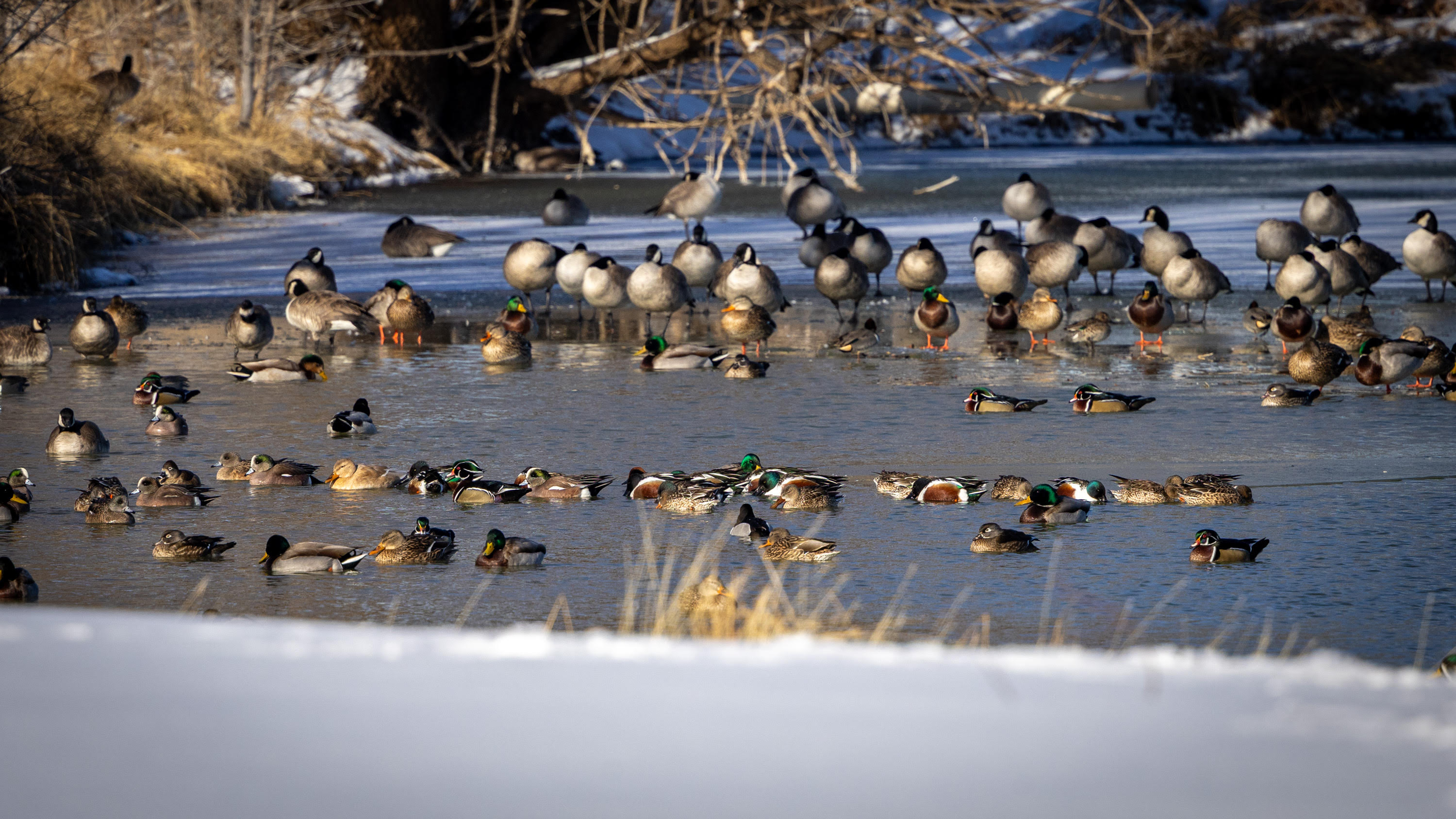 |
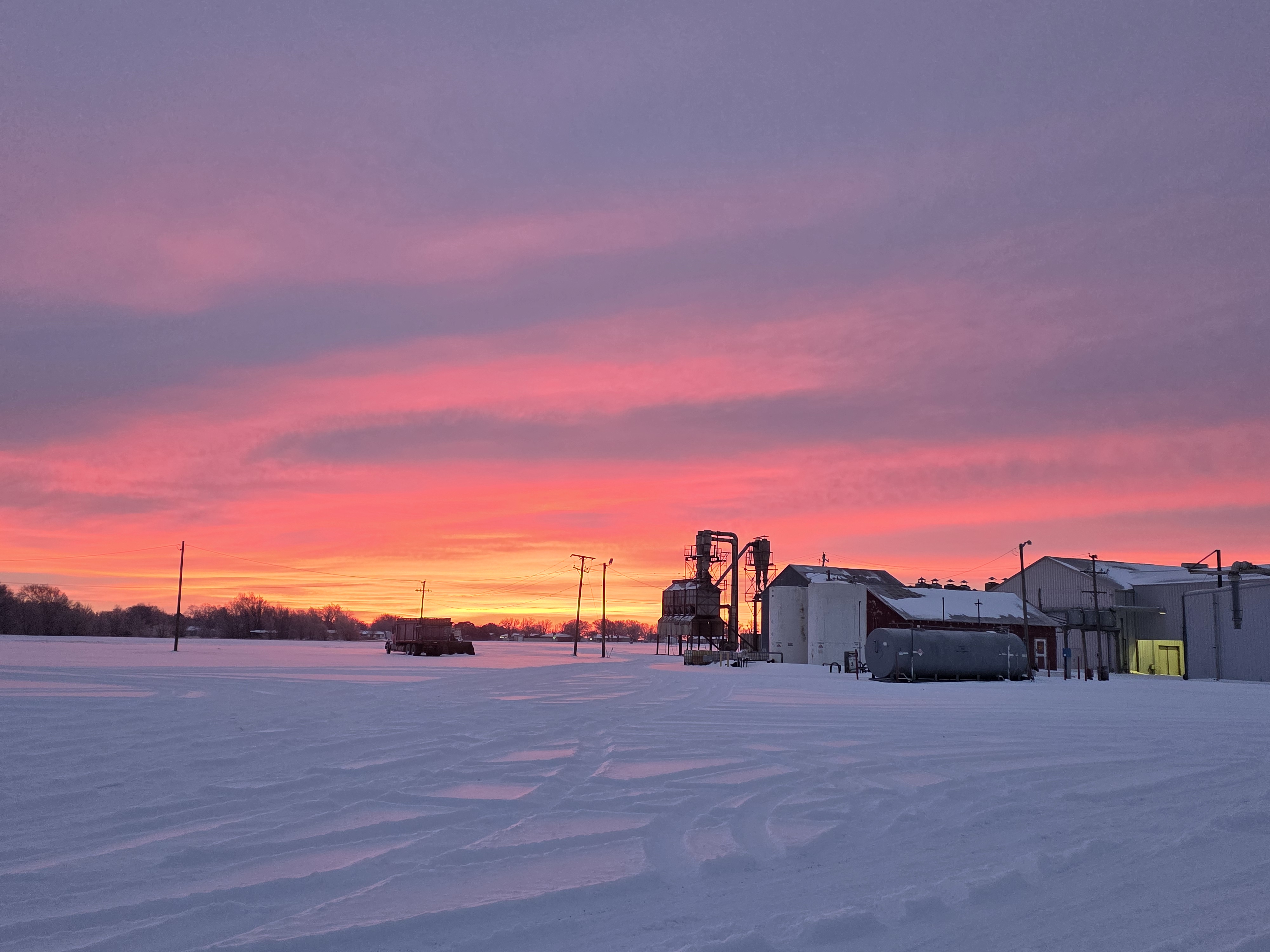
| Scenic post-snow pictures from around the area. The image on the left is of the WesTex Co-op Gin in O'Donnell Tuesday morning (27 January 2026). The image on the right is of the waterfowl enjoying some open water on a playa lake within the Lakeridge Country Club in Lubbock on Monday afternoon. The pictures are courtesy of Fernando Acosta (via KCBD) and Erin Shaw, respectively. | |
|
The snowy scenes made for nice pictures, though the prolonged cold was difficult on outdoor wildlife and kept roadways hazardous for many days. |
|
 |
|
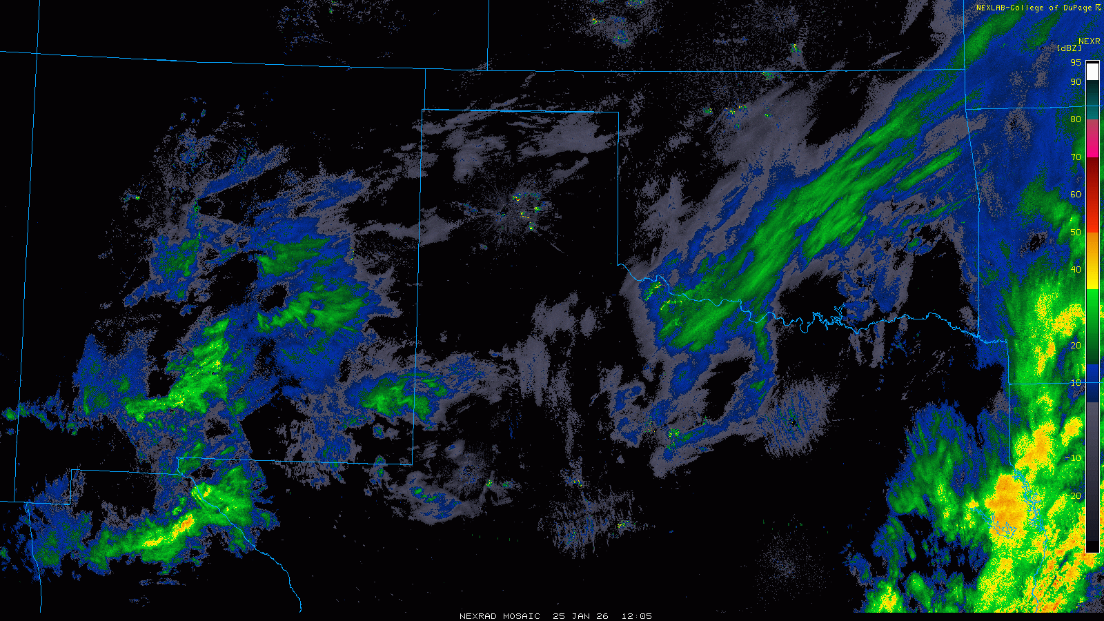
| Regional radar animation valid from 6:15 am to 2:25 pm on Sunday (25 January 2026). An additional radar animation, valid from 2:30 pm to 7:04 pm on Saturday (24 January), can be FOUND HERE. A regional animation, valid from 1:25 pm on Friday to 5:25 am on Sunday, can be VIEWED HERE. | |
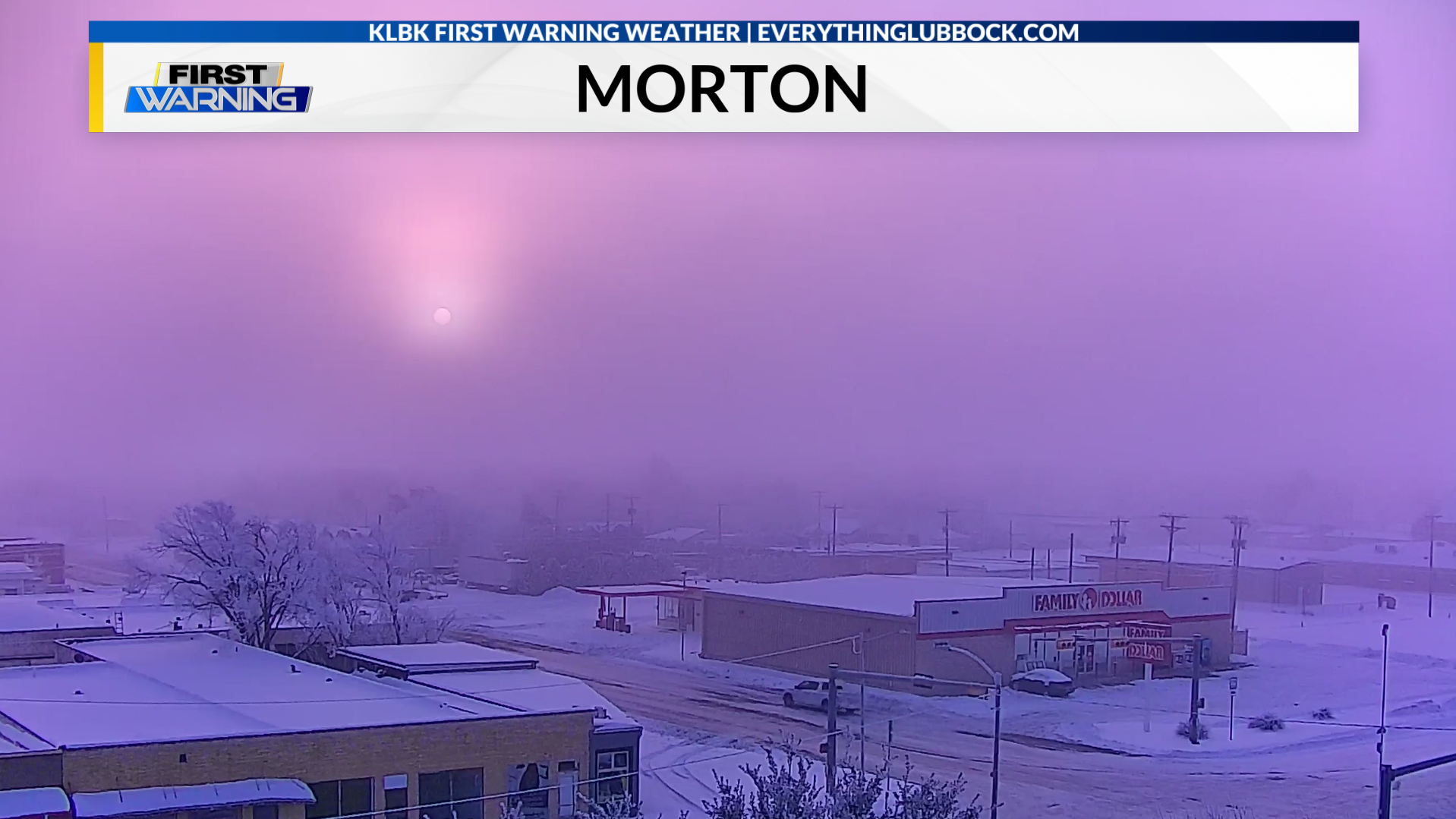
| Although the wintry precipitation quickly diminished and shifted east by late Sunday afternoon, clearing skies and light winds promoted the development of areas of freezing fog by early Monday morning. The freezing fog made for an ominous sight and deposited ice on exposed surfaces, further enhancing the winter wonderland. | |
 |
|
| Freezing fog in Morton Monday morning (26 January 2026). The image is courtesy of KLBK. | |
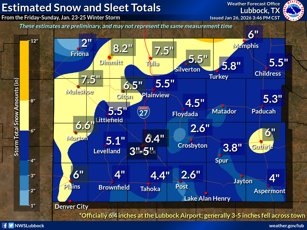
| By the conclusion of the multi-day winter storm, significant amounts of sleet and snow had blanketed the entire region. The heaviest accumulations, near and in excess of 6 inches, were found over the western and northwestern South Plains into the south-central Texas Panhandle. The remainder of the South Plains and much of the Rolling Plains tallied 3 to 6 inches of sleet and snow, while the far southwest Texas Panhandle, around Friona, only measured a couple of inches. | |
 |
|
| Graphic displaying the 3-day storm total snow and sleet from Friday through Sunday (23-25 January 2026). The image was created using reports from Cooperative Observers, the Official Weather Observers at the Lubbock Airport and the general public. | |
| Officially, the weather observers at the Lubbock Airport measured 6.4 inches of sleet and snow over the three-day stretch which melted down to 0.63 inches of liquid equivalent. The snowfall on January 23rd (0.8 inches) and 25th (3.2 inches) set new daily snowfall records, but the snow on the 24th (2.4 inches) came up well shy of the 7.2 inches that fell in 2023. | |
 |
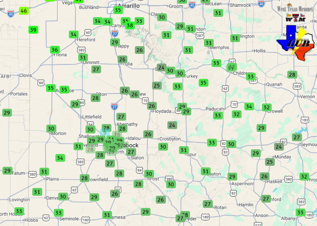 |
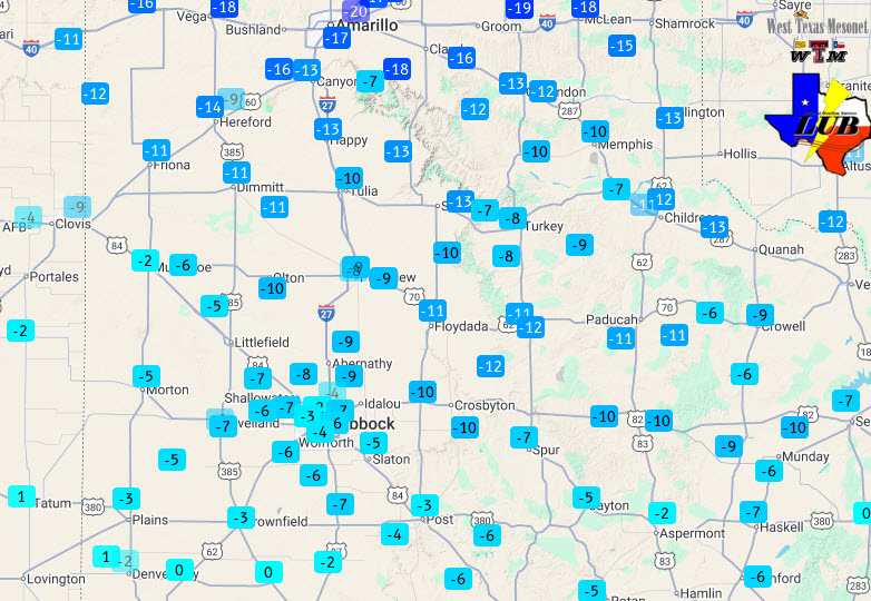
| Monday morning's lows (left) and Monday afternoon's highs (right) measured by the West Texas Mesonet (26 January 2026). Low temperatures measured by the West Texas Mesonet Tuesday morning (27 January) can be VIEWED HERE. | |
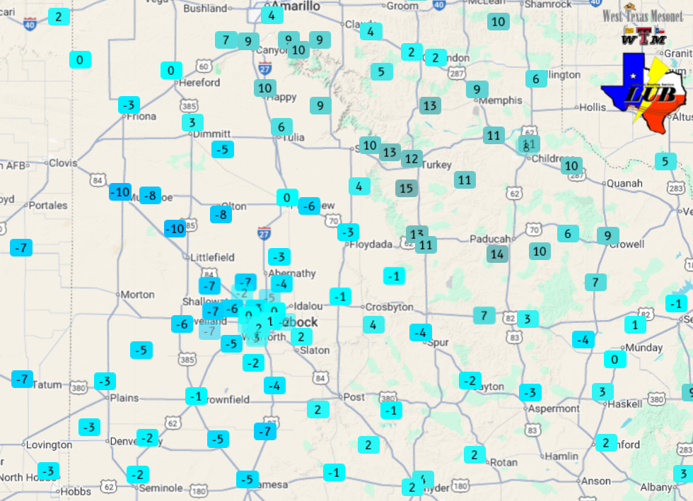
| The fresh snowpack, mostly clear skies and light winds allowed temperatures to plunge Sunday night, resulting in the coldest temperatures of the event over much of the Caprock and southern Rolling Plains Monday morning (26 January). Most spots dropped to or below zero, including an incredible -10˚F at the Muleshoe and Amherst WTM sites. Lubbock's official low was -2˚F, which shattered the previous daily record of 7˚F from 1966. This temperature tied for the 18th coldest of all time on record at Lubbock and it hadn't been this cold since December 22nd of 1989! The last time the temperature in Lubbock was colder than this was way back in 1971 when it reached -4˚F on January 5th. | |
 |
|
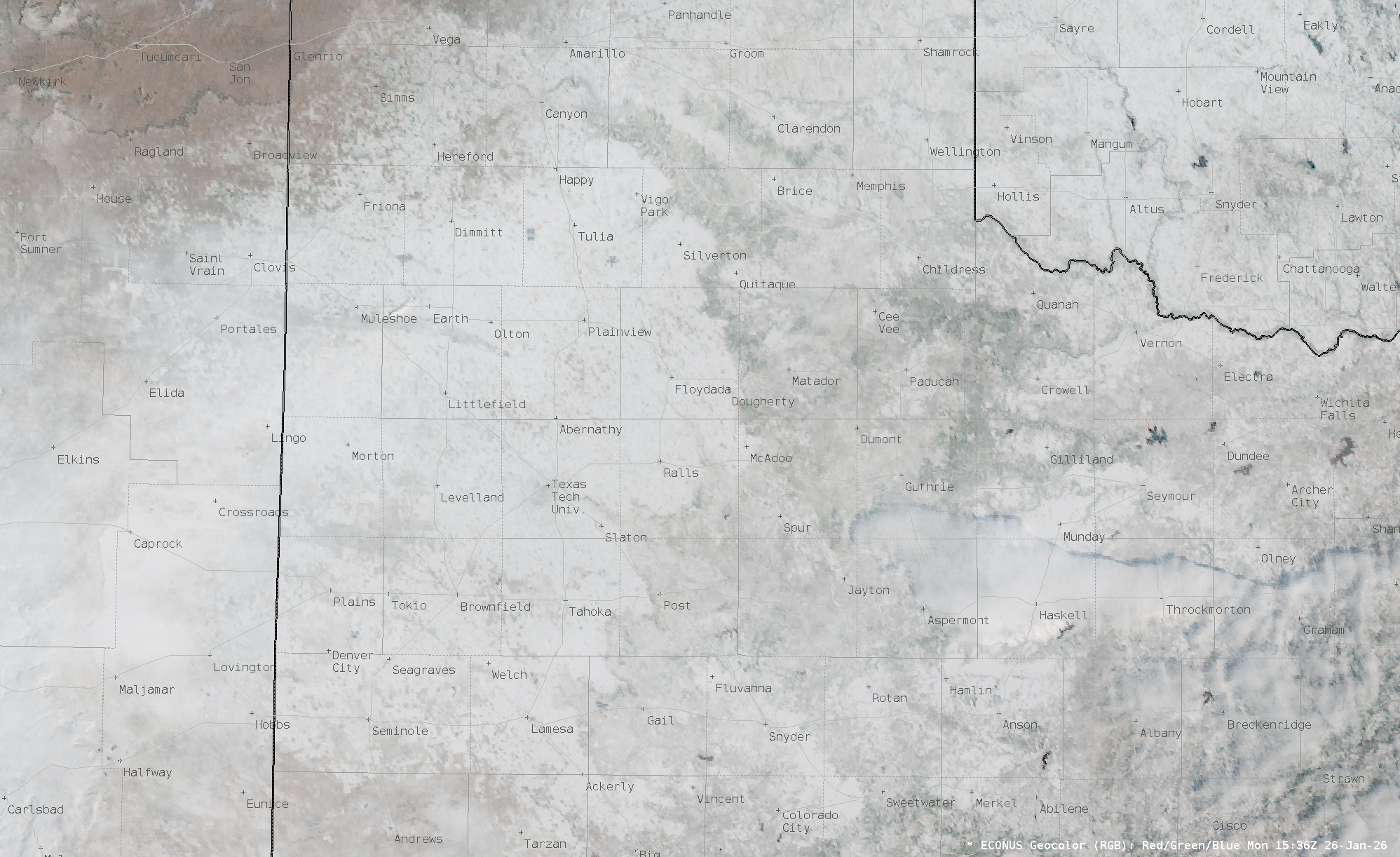
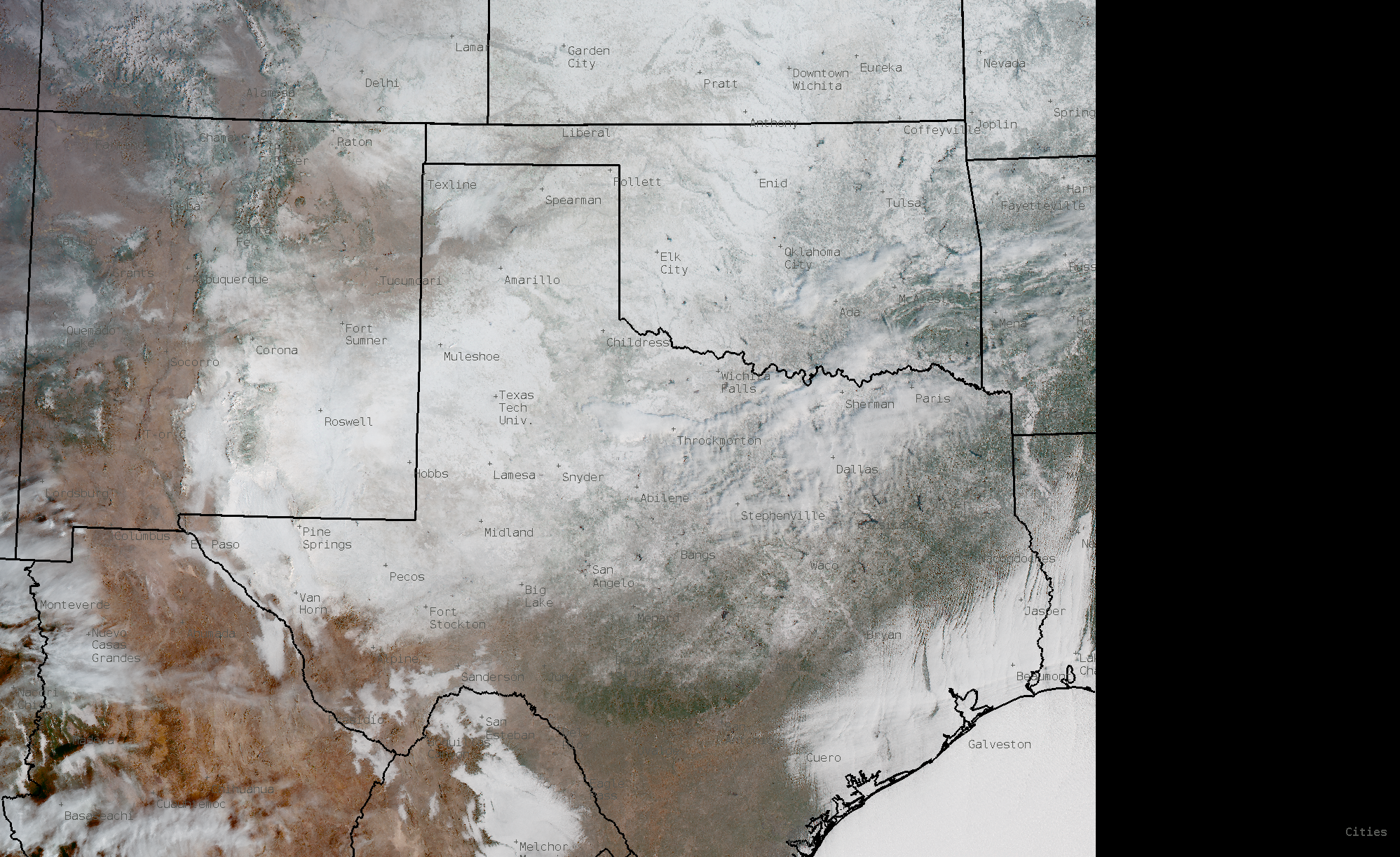
| Visible satellite image showing the widespread snow cover on Monday morning (26 January 2026). A wider view of the region can be FOUND HERE. Additionally, a visible satellite animation of the entire Continental U.S. Monday morning can be VIEWED HERE, with a regional animation HERE. | |
| The extent of the winter storm was evident from space on Monday when clear skies allowed for an unimpeded view. A broad snowpack (white) blanketed all of the South Plains region, much of the northern half to two-thirds of Texas, and a large swath of the central and eastern United States. | |
 |
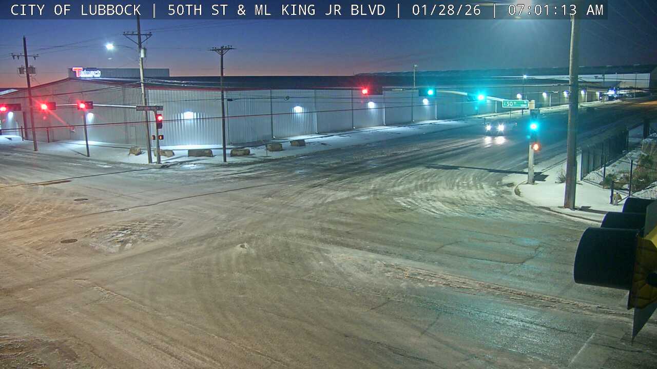 |
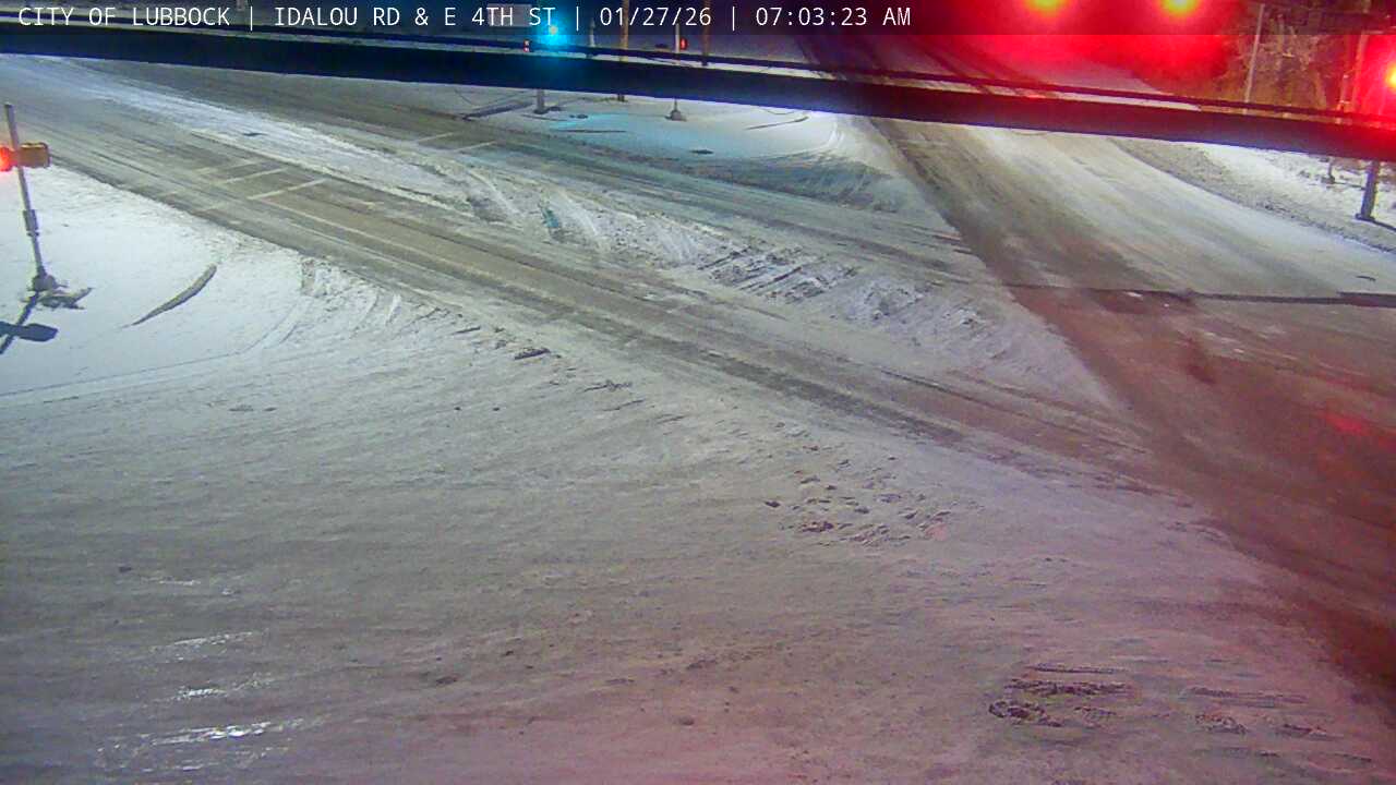
| Snow/ice-covered roadways at: (left) 4th Street and Idalou Round in Lubbock at 7:03 am on Tuesday (27 January 2026); and (right) 50th Street and Martin Luther King Jr. Boulevard at 7:01 am on Wednesday (28 January 2026). The images are courtesy of the City of Lubbock. | |
| High temperatures finally rebounded above freezing for the entire area Tuesday afternoon (27 January), reaching the 40s in most locations. Even so, residual sleet and snow, combined with cold overnight temperatures, kept travel hazardous, especially on residential streets and secondary roadways much of Tuesday and again Wednesday morning (28 January). | |
Preliminary Local Storm Report...Summary
National Weather Service Lubbock TX
215 PM CST Mon Jan 26 2026

..TIME...   ...EVENT...      ...CITY LOCATION...     ...LAT.LON...
..DATE...   ....MAG....      ..COUNTY LOCATION..ST.. ...SOURCE....
            ..REMARKS..

0900 AM     Snow             Denver City             32.97N 102.83W
01/26/2026  M6.0 Inch        Yoakum             TX   CO-OP Observer

            Event total snow (and sleet).

0900 AM     Snow             Plains                  33.19N 102.83W
01/26/2026  E6.0 Inch        Yoakum             TX   Law Enforcement


0900 AM     Snow             Brownfield              33.18N 102.27W
01/26/2026  M4.0 Inch        Terry              TX   CO-OP Observer

            Event total snow (and sleet).

0900 AM     Snow             3 ENE Tulia             34.56N 101.72W
01/26/2026  M7.5 Inch        Swisher            TX   CO-OP Observer

            Event total snow (and sleet).

0900 AM     Snow             Vigo Park               34.65N 101.50W
01/26/2026  E8.0 Inch        Swisher            TX   CO-OP Observer

            Event total snow (and sleet).

0900 AM     Snow             1 NNW Aspermont         33.15N 100.23W
01/26/2026  M4.0 Inch        Stonewall          TX   CO-OP Observer

            Event total snow (and sleet).

0900 AM     Snow             Friona                  34.64N 102.72W
01/26/2026  M1.7 Inch        Parmer             TX   CO-OP Observer

            Event total snow (and sleet).

0900 AM     Snow             2 E Flomot              34.23N 100.96W
01/26/2026  M4.0 Inch        Motley             TX   CO-OP Observer

            Event total snow (and sleet).

0900 AM     Snow             1 NE Matador            34.03N 100.81W
01/26/2026  M3.6 Inch        Motley             TX   CO-OP Observer

            Event total snow (and sleet).

0900 AM     Snow             2 S Northfield          34.26N 100.60W
01/26/2026  M4.1 Inch        Motley             TX   Public

            Event total snow (and sleet).

0900 AM     Snow             Roaring Springs         33.90N 100.86W
01/26/2026  M3.8 Inch        Motley             TX   CO-OP Observer

            Event total snow (and sleet).

0900 AM     Snow             1 WNW Tahoka            33.17N 101.81W
01/26/2026  M4.4 Inch        Lynn               TX   CO-OP Observer

            Event total snow (and sleet).

0356 PM     Snow             4 E Reese Center        33.59N 101.96W
01/25/2026  M4.5 Inch        Lubbock            TX   Public


0546 PM     Snow             1 NNW Lubbock Int. Airp 33.67N 101.82W
01/25/2026  M6.4 Inch        Lubbock            TX   Official NWS Obs

            Corrects previous snow report from 1 NNW
            Lubbock Int. Airport. This is the official
            storm total snowfall (and sleet) observed at
            the Lubbock Airport.

0700 AM     Snow             3 E Reese Center        33.59N 101.97W
01/26/2026  M3.8 Inch        Lubbock            TX   Public

            Storm event total snow and sleet. Picture
            and report from social media.

0900 AM     Snow             7 SW Lubbock            33.51N 101.93W
01/26/2026  M4.0 Inch        Lubbock            TX   CO-OP Observer

            Event total snow (and sleet).

0900 AM     Snow             4 ENE Wolfforth         33.52N 101.95W
01/26/2026  M4.2 Inch        Lubbock            TX   NWS Employee

            Event total snow (and sleet).

0900 AM     Snow             1 SW Slaton             33.43N 101.66W
01/26/2026  M4.3 Inch        Lubbock            TX   CO-OP Observer

            Event total snow (and sleet).

0900 AM     Snow             Shallowater             33.69N 101.99W
01/26/2026  M5.2 Inch        Lubbock            TX   NWS Employee

            Event total snow (and sleet).

0900 AM     Snow             3 WNW Woodrow           33.46N 101.89W
01/26/2026  M4.7 Inch        Lubbock            TX   NWS Employee

            Event total snow (and sleet).

0147 PM     Snow             4 SSW Lubbock           33.53N 101.88W
01/26/2026  M4.0 Inch        Lubbock            TX   NWS Employee

            Event total snow (and sleet).

0900 AM     Snow             5 SW Littlefield        33.87N 102.26W
01/26/2026  M5.8 Inch        Lamb               TX   CO-OP Observer

            Event total snow (and sleet).

0900 AM     Snow             1 S Olton               34.17N 102.14W
01/26/2026  M6.5 Inch        Lamb               TX   CO-OP Observer

            Event total snow (and sleet).

0900 AM     Snow             Dumont                  33.81N 100.52W
01/26/2026  M3.0 Inch        King               TX   CO-OP Observer

            Event total snow (and sleet).

0900 AM     Snow             Guthrie                 33.63N 100.34W
01/26/2026  M6.0 Inch        King               TX   CO-OP Observer

            Event total snow (and sleet).

0900 AM     Snow             15 S Paducah            33.82N 100.31W
01/26/2026  M3.0 Inch        King               TX   CO-OP Observer

            Event total snow (and sleet).

0430 PM     Snow             4 WSW Pep               33.79N 102.61W
01/25/2026  M7.0 Inch        Hockley            TX   CO-OP Observer

            Storm event total snow and sleet.

0900 AM     Snow             2 SSW Levelland         33.55N 102.38W
01/26/2026  M5.1 Inch        Hockley            TX   Public

            Event total snow (and sleet).

0900 AM     Snow             6 N Ropesville          33.49N 102.19W
01/26/2026  M5.0 Inch        Hockley            TX   CO-OP Observer

            Event total snow (and sleet).

0900 AM     Snow             Memphis                 34.73N 100.54W
01/26/2026  E6.0 Inch        Hall               TX   CO-OP Observer

            Event total snow (and sleet).

0900 AM     Snow             Turkey                  34.39N 100.89W
01/26/2026  E5.8 Inch        Hall               TX   CO-OP Observer

            Event total snow (and sleet).

0900 AM     Snow             Plainview               34.19N 101.70W
01/26/2026  M4.3 Inch        Hale               TX   CO-OP Observer

            Event total snow (and sleet).

0900 AM     Snow             1 WNW Plainview         34.20N 101.75W
01/26/2026  M4.9 Inch        Hale               TX   CO-OP Observer

            Event total snow (and sleet).

0900 AM     Snow             Abernathy               33.84N 101.85W
01/26/2026  M4.8 Inch        Hale               TX   CO-OP Observer

            Event total snow (and sleet).

0900 AM     Snow             Lake Alan Henry         33.07N 101.05W
01/26/2026  M5.2 Inch        Garza              TX   CO-OP Observer

            Event total snow (and sleet).

0900 AM     Snow             Post                    33.19N 101.38W
01/26/2026  M2.5 Inch        Garza              TX   Postal Employee

            Event total snow (and sleet).

0900 AM     Snow             Southland               33.36N 101.55W
01/26/2026  M3.3 Inch        Garza              TX   CO-OP Observer

            Event total snow (and sleet).

0900 AM     Snow             Floydada                33.98N 101.33W
01/26/2026  M2.5 Inch        Floyd              TX   Law Enforcement

            Event total snow (and sleet).

0900 AM     Snow             1 WSW Floydada          33.98N 101.34W
01/26/2026  E4.5 Inch        Floyd              TX   CO-OP Observer

            Event total snow (and sleet).

0900 AM     Snow             9 SE Floydada           33.88N 101.25W
01/26/2026  M3.4 Inch        Floyd              TX   CO-OP Observer

            Event total snow (and sleet).

0900 AM     Snow             1 W Spur                33.48N 100.88W
01/26/2026  E3.8 Inch        Dickens            TX   CO-OP Observer

            Event total snow (and sleet).

0900 AM     Snow             3 WNW Crosbyton         33.66N 101.28W
01/26/2026  M2.5 Inch        Crosby             TX   CO-OP Observer

            Event total snow (and sleet).

0900 AM     Snow             2 SSE White River Lake  33.46N 101.09W
01/26/2026  M5.8 Inch        Crosby             TX   CO-OP Observer

            Event total snow (and sleet).

0900 AM     Snow             10 S Paducah            33.88N 100.38W
01/26/2026  M5.3 Inch        Cottle             TX   CO-OP Observer

            Event total snow (and sleet).

0900 AM     Snow             7 E Paducah             34.02N 100.18W
01/26/2026  M5.1 Inch        Cottle             TX   CO-OP Observer

            Event total snow (and sleet).

0900 AM     Snow             Morton                  33.72N 102.76W
01/26/2026  M6.6 Inch        Cochran            TX   CO-OP Observer

            Event total snow (and sleet).

0900 AM     Snow             Childress               34.43N 100.22W
01/26/2026  M5.3 Inch        Childress          TX   CO-OP Observer

            Event total snow (and sleet).

0900 AM     Snow             5 S Dodson              34.69N 100.03W
01/26/2026  M6.0 Inch        Childress          TX   CO-OP Observer


0900 AM     Snow             1 W Kirkland            34.39N 100.09W
01/26/2026  E5.0 Inch        Childress          TX   CO-OP Observer

            Event total snow (and sleet).

0900 AM     Snow             3 S Tell                34.34N 100.40W
01/26/2026  M5.3 Inch        Childress          TX   CO-OP Observer

            Event total snow (and sleet).

0900 AM     Snow             7 NW Childress          34.52N 100.29W
01/26/2026  M4.4 Inch        Childress          TX   CO-OP Observer

            Event total snow (and sleet).

0900 AM     Snow             1 ESE Dimmitt           34.54N 102.30W
01/26/2026  M8.2 Inch        Castro             TX   CO-OP Observer

            Event total snow (and sleet).

0900 AM     Snow             1 S Hart                34.37N 102.12W
01/26/2026  M5.7 Inch        Castro             TX   CO-OP Observer

            Event total snow (and sleet).

0900 AM     Snow             Silverton               34.47N 101.30W
01/26/2026  M5.5 Inch        Briscoe            TX   CO-OP Observer

            Event total snow (and sleet).

0900 AM     Snow             1 SSW Muleshoe          34.22N 102.73W
01/26/2026  M4.1 Inch        Bailey             TX   CO-OP Observer

            Event total snow (and sleet).

0900 AM     Snow             1 WNW Muleshoe Wildlife 33.95N 102.77W
01/26/2026  M7.5 Inch        Bailey             TX   CO-OP Observer

            Event total snow (and sleet).

