
 2025 was the 2nd WARMEST year on record for Lubbock, finishing just behind 2024. The warmth was punctuated by an very warm/hot fall and concluded with a dry but record warm last two-thirds of December which included the warmest Christmas on record (high of 86°F!). Impressively, 11 of the 12 months recorded above average temperatures, with only January finishing cooler than normal. Over the course of the year rainfall was scarce early-on, increased in frequency and quantity through much of the growing season, and became more elusive in fall. The relatively well-timed rains, in combination with bountiful rain in November of 2024 (priming the sub-soil), and a hot, but not scorching summer, provided a good growing season for many. Lubbock finished the year with 17.51 inches, just shy of average and 60th wettest, or 56th driest, on record. The most impactful event of the year for the South Plains region was the result of a supercell thunderstorm that produced 8 tornadoes and significant wind-driven hail as it moved through the western and central South Plains the afternoon and evening of June 5th. The tornadoes inflicted significant damage when they encountered structures north and northwest of Morton, north and northeast of Levelland, northeast and east of Smyer and around Reese Center. Assessments of the damage resulted in three of the tornadoes obtaining an EF2 rating and two others garnering an EF1 rating. The year ended with an average yearly temperature of 64.7°F, an astounding 3.3°F above the 1991-2020 30-year average of 61.4°F, and only 0.1°F off the record warmest year (2024). 2025 was the 2nd WARMEST year on record for Lubbock, finishing just behind 2024. The warmth was punctuated by an very warm/hot fall and concluded with a dry but record warm last two-thirds of December which included the warmest Christmas on record (high of 86°F!). Impressively, 11 of the 12 months recorded above average temperatures, with only January finishing cooler than normal. Over the course of the year rainfall was scarce early-on, increased in frequency and quantity through much of the growing season, and became more elusive in fall. The relatively well-timed rains, in combination with bountiful rain in November of 2024 (priming the sub-soil), and a hot, but not scorching summer, provided a good growing season for many. Lubbock finished the year with 17.51 inches, just shy of average and 60th wettest, or 56th driest, on record. The most impactful event of the year for the South Plains region was the result of a supercell thunderstorm that produced 8 tornadoes and significant wind-driven hail as it moved through the western and central South Plains the afternoon and evening of June 5th. The tornadoes inflicted significant damage when they encountered structures north and northwest of Morton, north and northeast of Levelland, northeast and east of Smyer and around Reese Center. Assessments of the damage resulted in three of the tornadoes obtaining an EF2 rating and two others garnering an EF1 rating. The year ended with an average yearly temperature of 64.7°F, an astounding 3.3°F above the 1991-2020 30-year average of 61.4°F, and only 0.1°F off the record warmest year (2024). The graphic below highlights some of the more significant weather events that occurred across the area in 2025. January 9th brought the first shot of snow in 2025, with most locations seeing a little wintry weather, and a heavy swath of snow (4-6+ inches) impacting the southwest Texas Panhandle. Dusty and warm winds in mid-January proceeded a prolonged stretch of subfreezing temperatures, complete with a little light snow for some. March 8th brought another swath of 4-8 inches of snow, this time targeting the south-central into the southeast Texas Panhandle, from Silverton to Northfield. Six days later, March 14th, an intense storm system brought hurricane force winds to the southern Texas Panhandle and northern South Plains and thick blowing dust to the entire region. A peak wind gust of 84 mph was measured by the West Texas Mesonet near Friona and Dimmitt. April 5th brought a late-season snow, as much as a foot in Silverton, and 4+ inches to much of the south-central Texas Panhandle and northern South Plains. Thunderstorms flourished in late April, with tennis-ball size hail falling in Littlefield on April 22nd, and softball size hail and DVD size hail falling outside of Post and southeast of Guthrie, respectively, on April 29th. In addition, April 24th brought tornadoes to rural portions of northeast Floyd and southwest Motley Counties as well southern Crosby and northeast Garza Counties, and April 25th brought additional tornadoes outside of Hart and southeast of Muleshoe to west of Littlefield. May was atypically devoid of thunderstorm activity, but one intense storm late in the month did generate a brief tornado along with hail estimated to be about 6 inches in diameter (the size of melon or large grapefruit!) near Afton on May 25th. This same slow-moving storm dumped torrential rain as it moved across the central Rolling Plains, causing the South Pease River (Tongue River) to swell and inundate many campsites partaking in the Memorial Day Weekend south of Roaring Springs. Another isolated, but intense, thunderstorm dropped softball size hail north of Brownfield on May 29th. A week later, on June 5th, an intense supercell thunderstorm spawned 8 tornadoes, a few of them significant, as it moved north of Morton, Whiteface and Levelland, northeast of Smyer and across Reese Center. The following days, June 6th through 10th, provided additional rounds of severe thunderstorms and heavy rain, including an 80 mph gust measured in New Home on the 6th and a 90 mph gust near Lakeview on the 8th. The summer brought heat and occasional rain, including a quick 2-4 inches of rain to much of Lubbock on August 30th, which led to flooding at Ransom Canyon. The weather turned drier in fall, but it remained warm. In fact, November 15th brought the latest 90°F temperature ever recorded at Lubbock, and only the second time the mercury has touched 90°F in November, the first being November 9, 2006. December kept the warmth going, recording an all-time December record high of 86°F on Christmas Day, breaking the previous record of 85°F, set three days earlier, and shattering the daily record of 76°F (set back in 1955)!
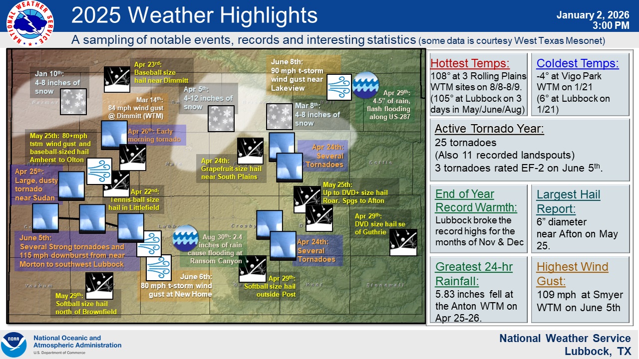 Notable weather impacts to the region in 2025. Note that this is just a sampling of events, many more have been omitted due to space constraints.
A total of 25 supercell tornadoes were observed in the Lubbock 24-county service area in 2025, greater than the long-term average of 18. The bulk of the tornadoes occurred on two very active days, including 10 tornadoes on April 24th and 8 tornadoes on June 5th. The tornadoes of April 24th included one that tracked nearly 10 miles, from approximately 10 miles southwest of Flomot to 8 miles west-southwest of Whiteflat, lasted 28 minutes, and had an estimated maximum width of 440 yards. No known damage was documented with this tornado, though chaser video did show trees and shrubs being lofted and power flashes as it moved through open ranch land. Given the lack of damage observed, an EFU (unknown) rating was assigned to this tornado. The remainder of the tornadoes on April 24th, including one west of Roaring Springs and 5 brief tornadoes northeast of Post all inflicted no known damage and were rated EFU. The following two days each brought a tornado, including a late-night twister that tracked about 17 miles, from near Springlake to west of Hart, between 1:28 am and 2:23 am on the 26th. Thankfully, the tornado evaded homes and structures and was also rated EFU. April concluded with a brief EFU tornado south of Anton on the 30th. A dearth of thunderstorm in May, climatologically the heart of severe weather season for West Texas, led to a single supercell tornado (a brief EFU about 8 miles east of Afton on the 25th) in May.
The biggest tornadic event of the year occurred on June 5th, when a long-track, intense supercell thunderstorm generated 8 tornadoes as it moved across the western and central South Plains. Several of these tornadoes were intense and lasted for tens of minutes as the storm tracked through northern Cochran, northern Hockley and into west-central Lubbock counties. Unfortunately, several of these tornadoes impacted structures and inflicted significant damage. Three of the tornadoes were rated EF2, including a wedge-type tornado that destroyed multiple large wooden power poles northwest of Morton, a strong tornado that rolled a semi-truck and damaged buildings and trees as it moved by north of Whitharral, and twister that damaged or destroyed several manufactured homes east and northeast of Smyer. Two other tornadoes acquired an EF1 rating, one that rolled two manufactured homes and injured two people northeast of Smyer, and the final tornado that toppled large trees and damaged roofs in southern portions of Reese Center. Fortunately, the vigorously rotating thunderstorm stopped producing tornadoes as it moved across the city of Lubbock, though large wind-driven hail caused a lot of damage to structures on the southwest side of town.
The following day, June 6th, brought 3 more tornadoes to the South Plains, this time near Sundown. However, unlike the previous day, all the tornadoes were short-lived, did no known damage and were rated EFU. No additional supercell tornadoes were documented in the NWS Lubbock County Warning Area the remainder of 2025, though landspout-type tornadoes were observed on a couple of days.
|
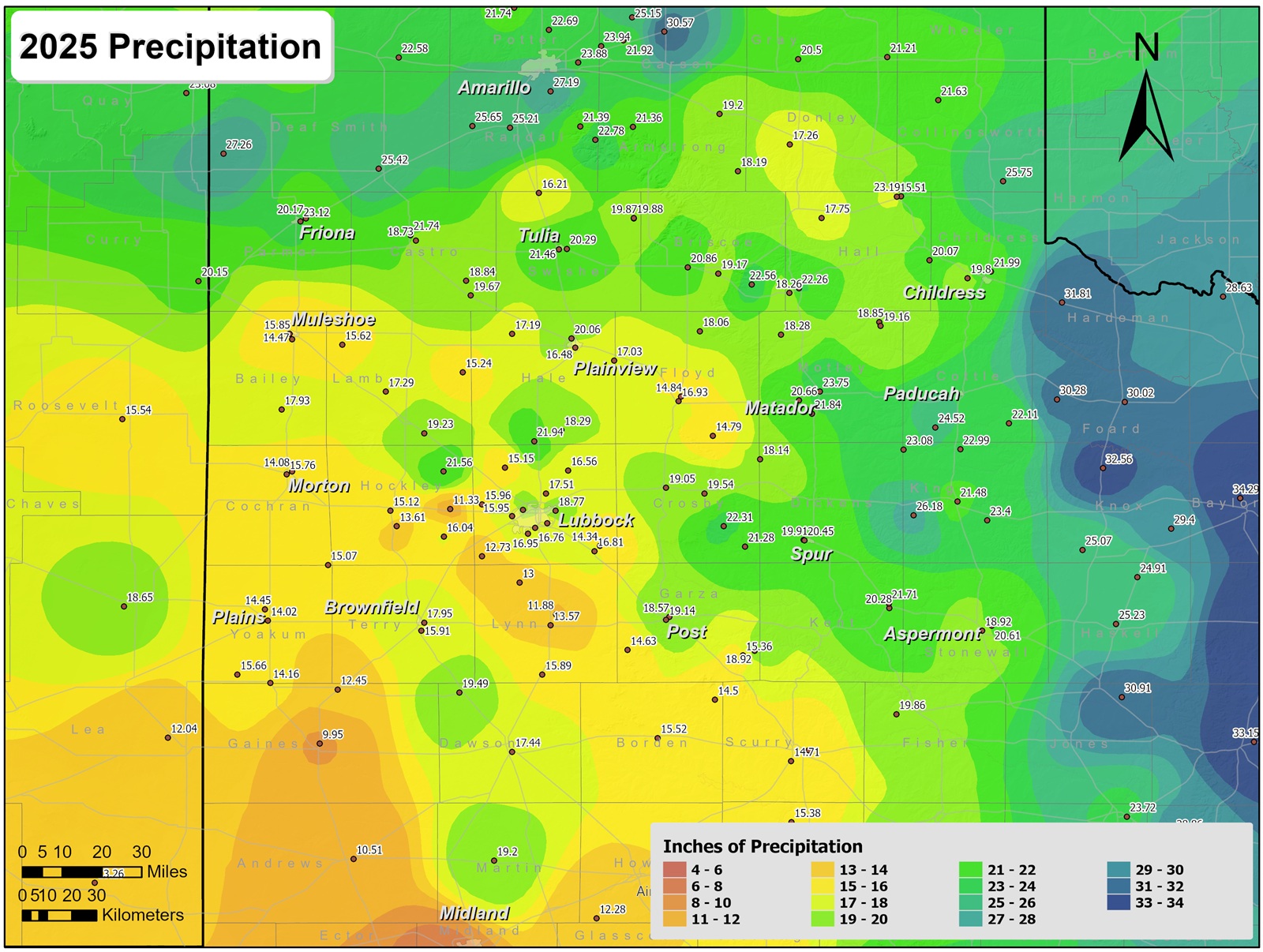
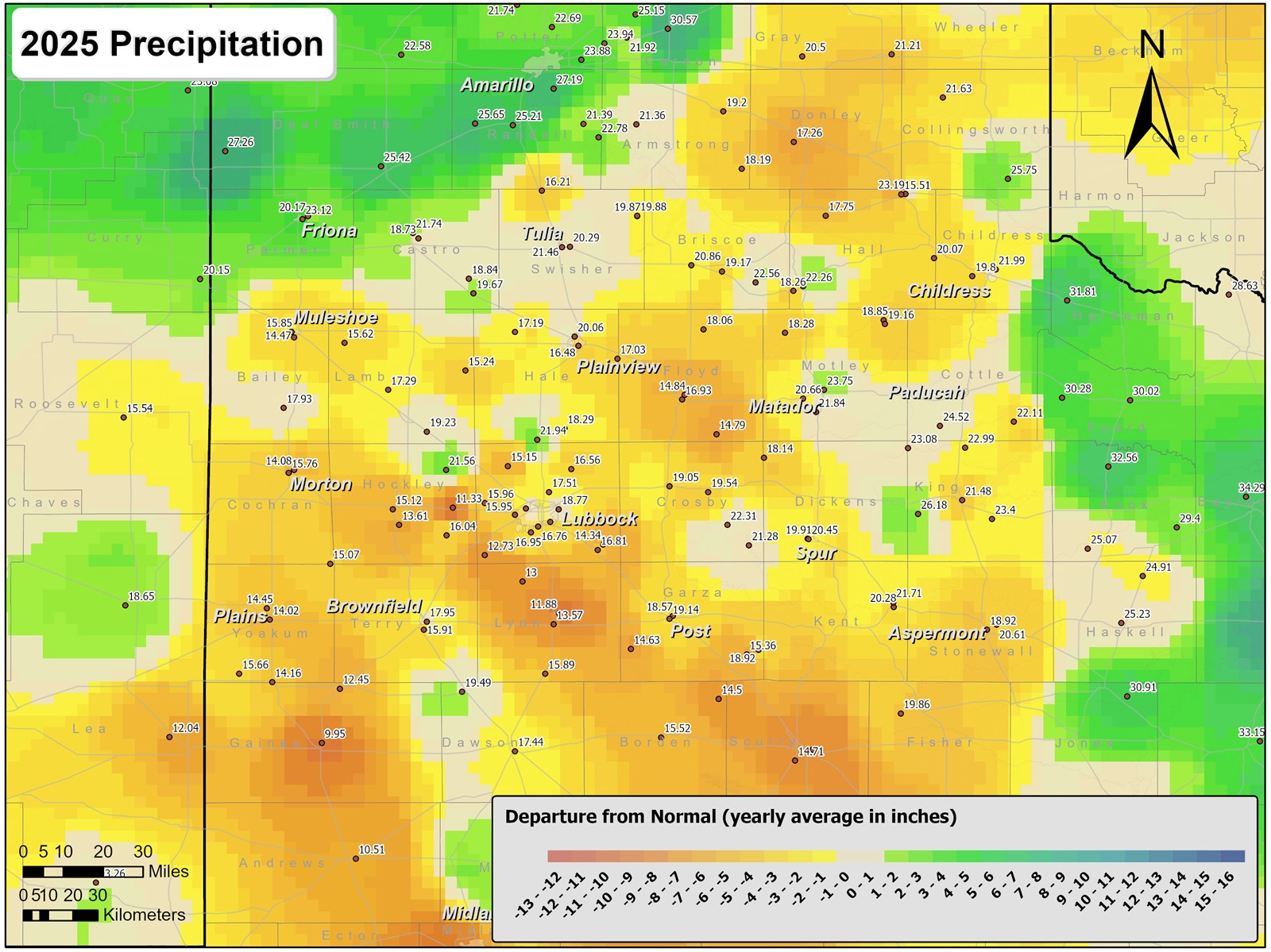
As is typical, precipitation totals in 2025 generally increased from west-to-east across the South Plains region. Rainfall was most difficult to come by over the southwest South Plains into southeast New Mexico, as well as over parts of the south-central and west central South Plains, where annual totals of 10 to 15 inches were common. The lowest total measured in the region was 9.95 inches at the West Texas Mesonet (WTM) site near Seminole. In contrast, the heaviest rain, 20 to 25+ inches, targeted many locations off the Caprock as well as over parts of the southern and central Texas Panhandle. The highest total measured in the Lubbock County Warning Area was 26.18 inches at the WTM 10 miles west of Guthrie. Totals in excess of 30 inches were found farther east, stretching from parts of western North Texas into the Big Country.
Lubbock International Airport officially recorded 17.51 inches of precipitation, 0.82 inches below the long-term average of 18.33 inches, or 96% of average. This was fairly similar to many locations within the city of Lubbock, where totals ranged from around 16 to over 18 inches. However, not far away, from southeast Hockley County through southwest Lubbock County and into northwest and central Lynn County, most spots saw less rain, generally from 12 to 14 inches.
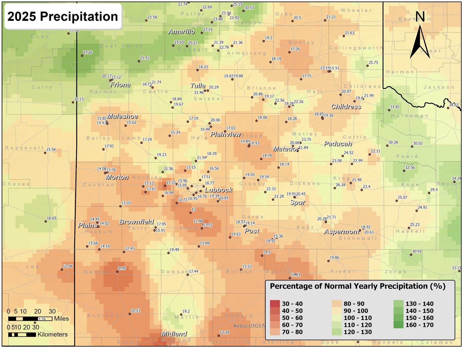
The map below shows the 2025 precipitation as a percent of the long-term average or "normal". The image illustrates the fact that most of the region had received average to below average rainfall in 2025, with a few select spots finishing the year slightly above average. Locations that fared best, with respect to average, were the western and southwest Texas Panhandle as well as much of western North Texas.
|
|
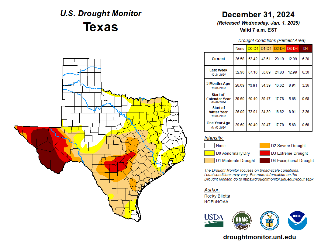
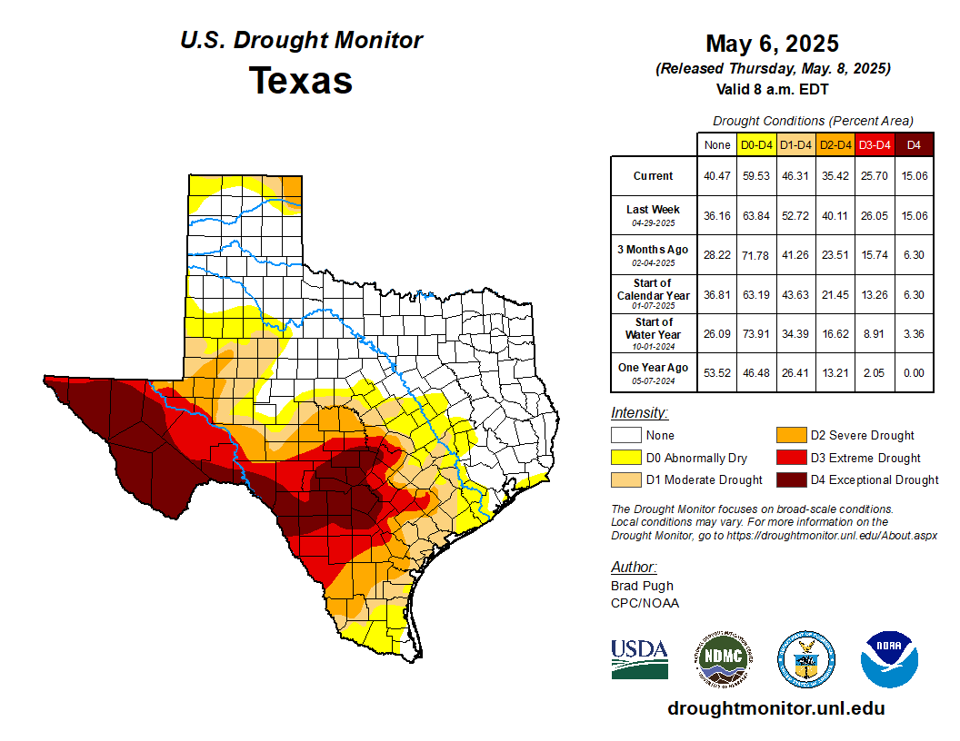
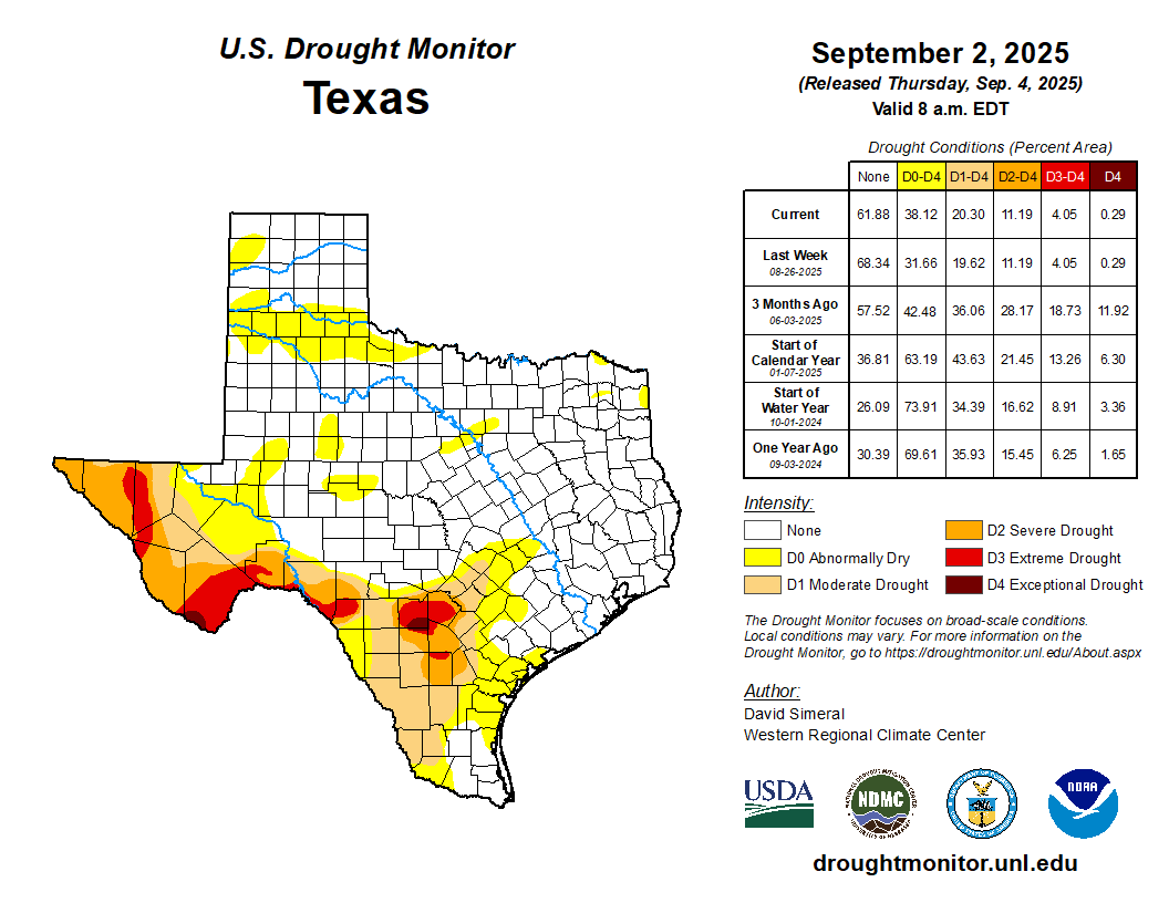
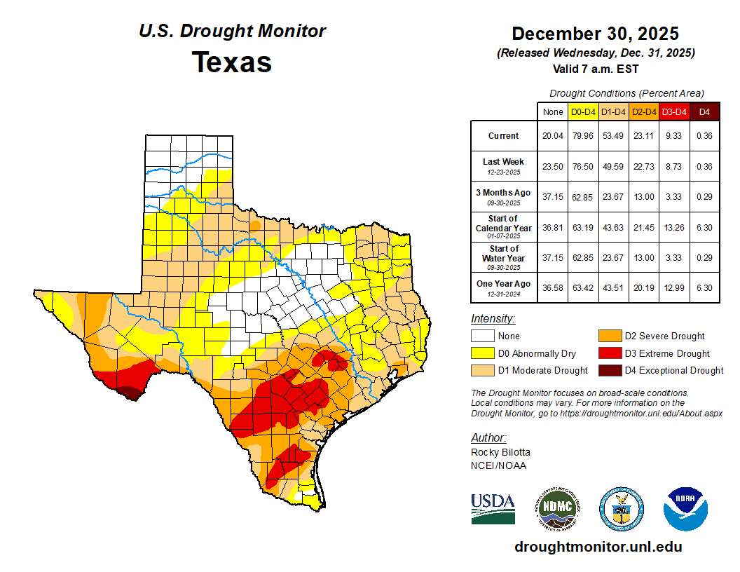
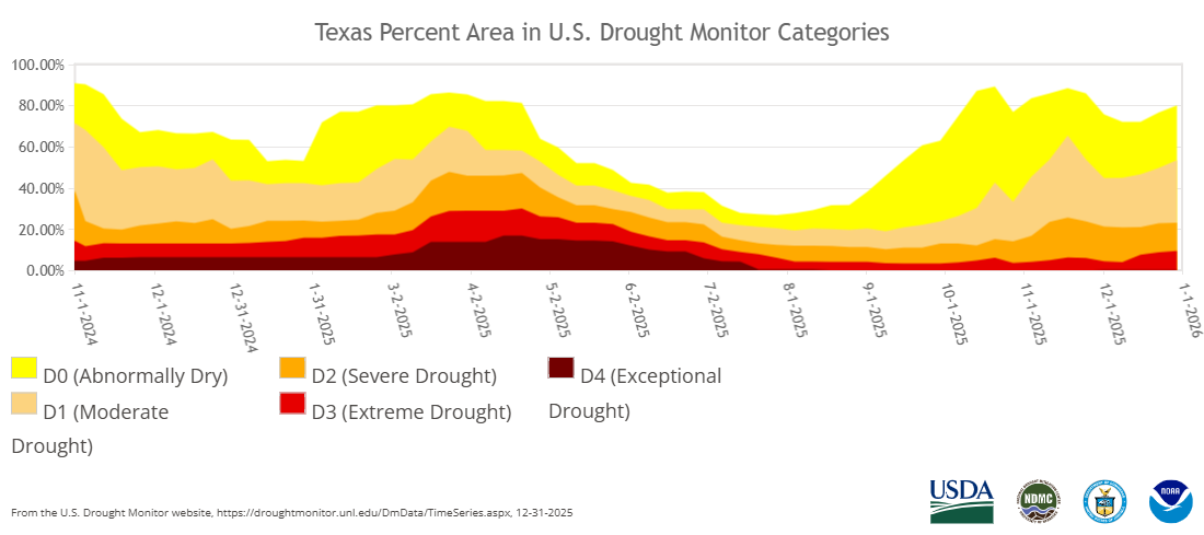
The year began free of drought across northwest Texas, thanks primarily to the widespread heavy rain that fell in November 2024. A dry start to 2025 allowed moderate to severe drought to develop and expand over much of the South Plains region by late March. The drought conditions eased through April and early May as showers and thunderstorms brought periodic rain to the region. Much of the remainder of May was on the dry side, but thunderstorms and rainfall returned with vigor in early June, and relatively regular rainfall continued through the remainder of the summer. This kept the region drought free through the summer, and also helped to mitigate temperatures from getting too hot. The meaningful rainfall largely shutoff in the fall, and coupled with well above average temperatures, it led to abnormally dry to moderate drought conditions returning to the region. Much farther south, where the exceptional drought was in place across much of Far West Texas to start 2025, welcome summer rain helped ameliorate conditions for all but a small portion of the Big Bend.
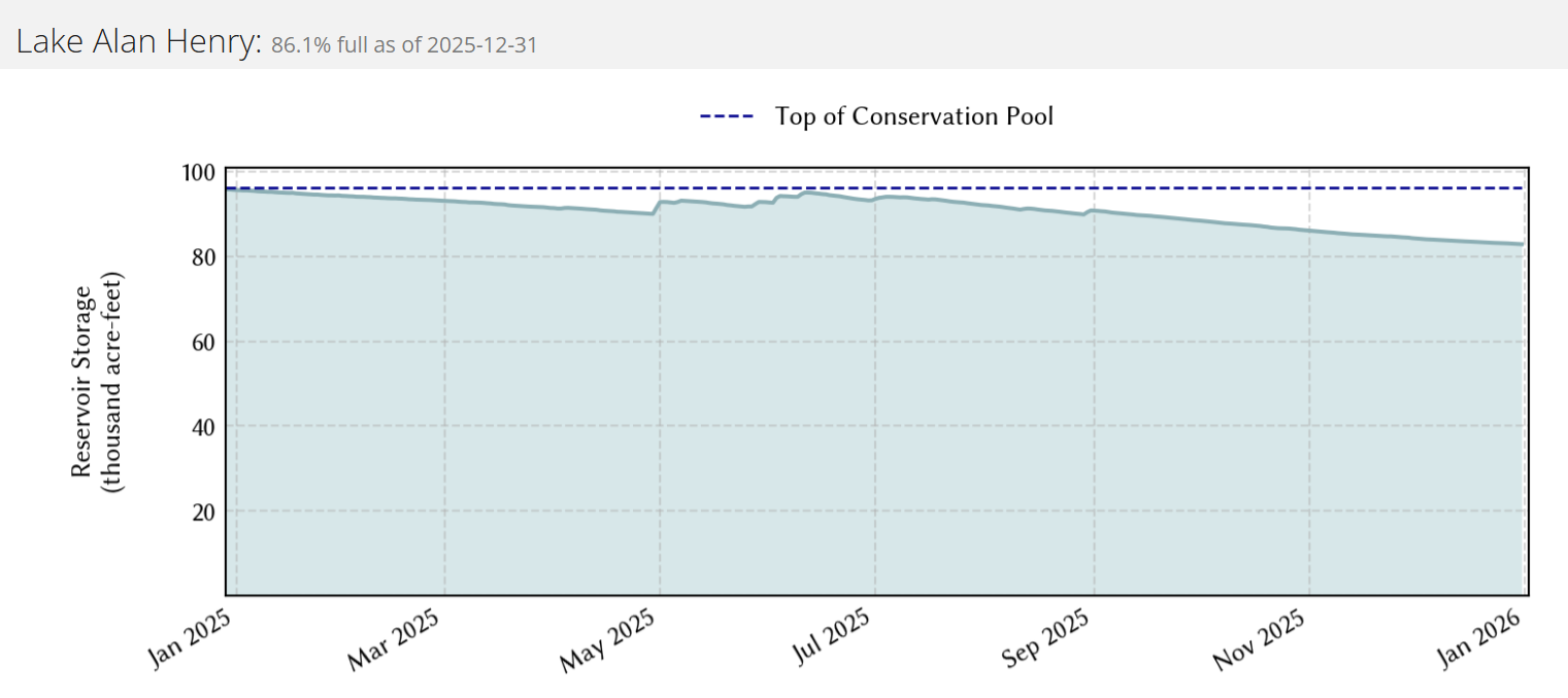
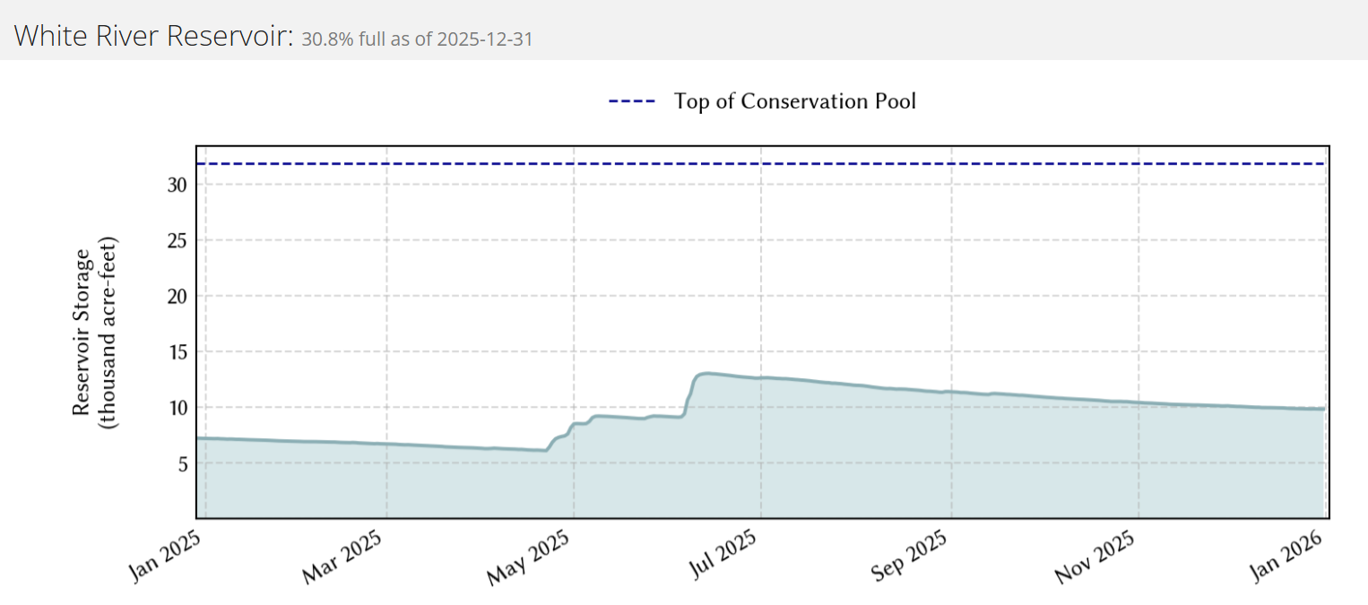
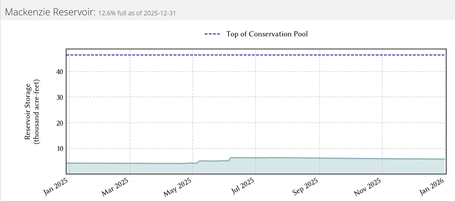
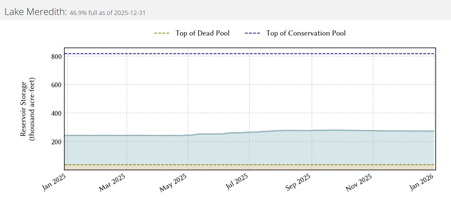
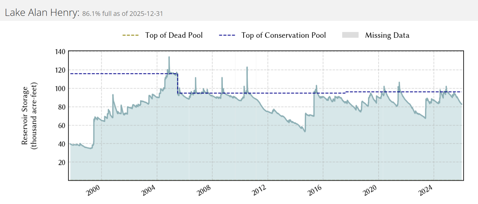
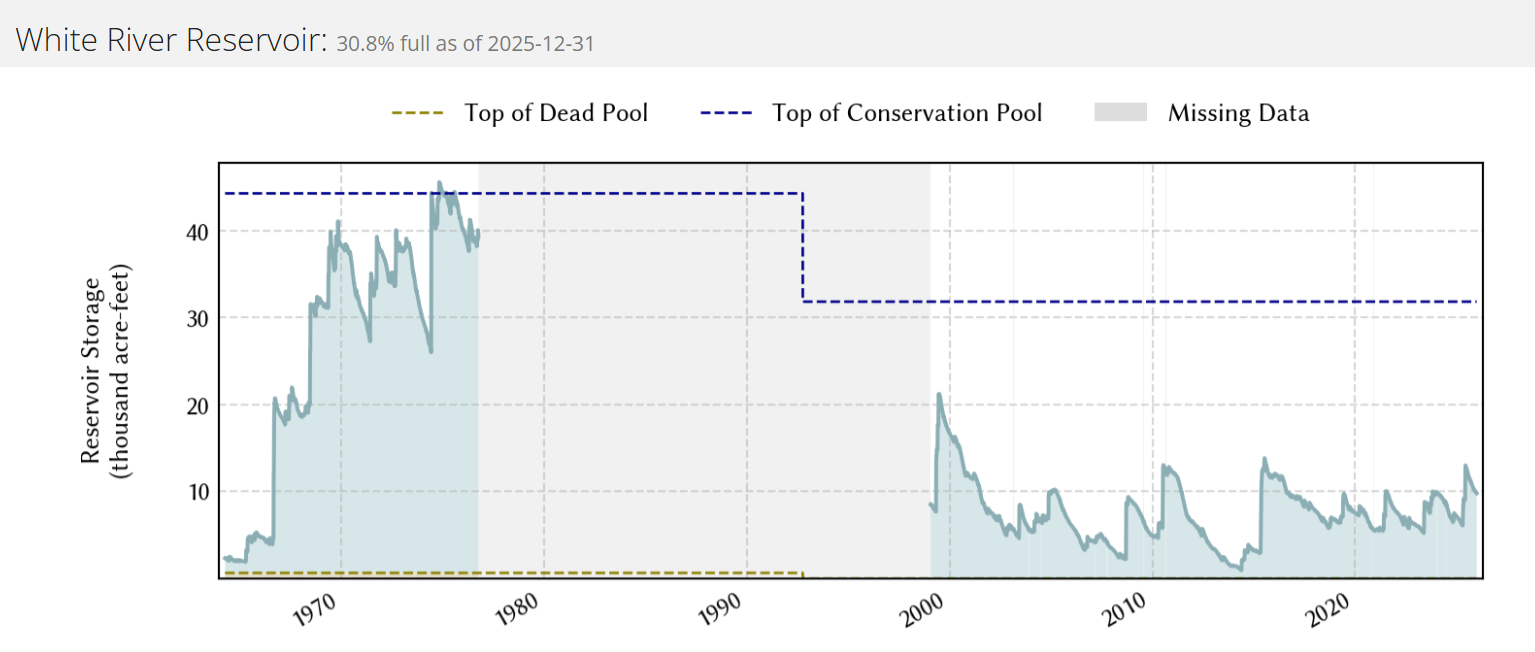
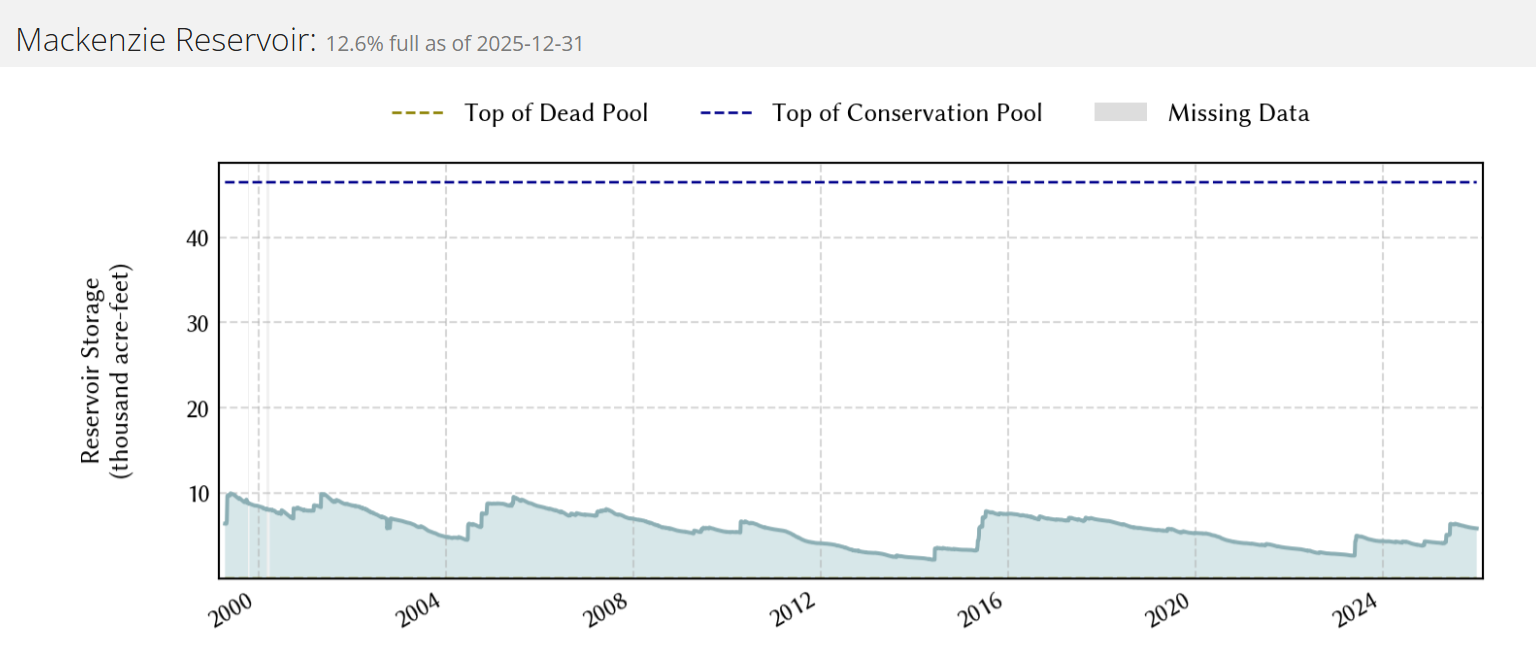
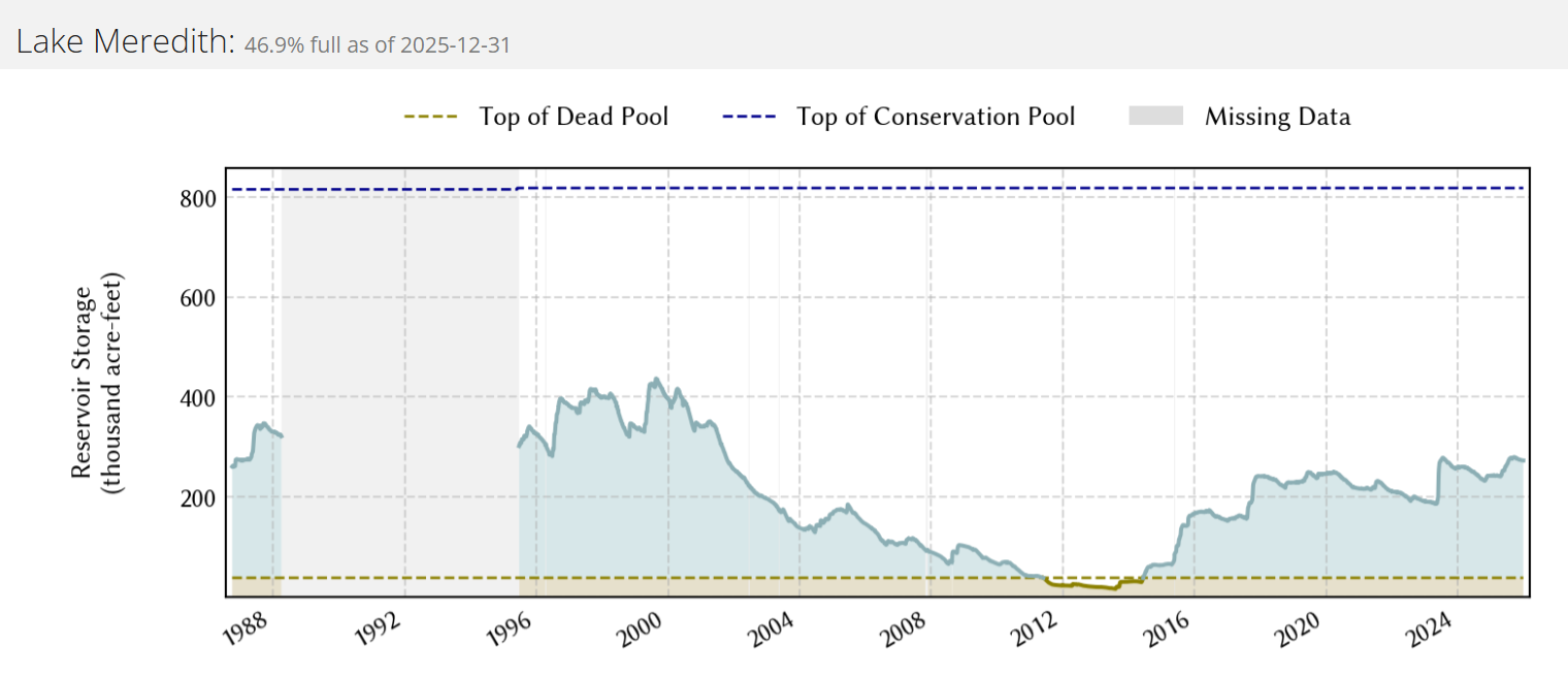
Area reservoir levels fell through the late winter and early spring, as precipitation was spotty and light. Several bouts of heavy rain from late May into June, and the resulting runoff, gave boosts to all of the reservoirs. Alan Henry came up just shy of full conservation level in early July, while both White River Lake and Mackenzie Reservoir measured significant rises. Thereafter, a slow downward trend was the general rule through late summer and fall as demand for the water continued, but rainfall dwindled. The exception was Lake Meredith, where the level held fairly steady through the fall after a modest rise late spring and summer. Over the course of 2025, area lake conservation levels had mixed responses, falling at Lake Alan Henry (from 100% to 86%) and rising at Lake Mackenzie (from 9% to 13%), White River Lake (from 23% to 31%) and Lake Meredith (from 41% to 47%).
|
||||||||||||||||||||
|
2025 will go down in the books as the 2nd warmest and 60th wettest (or 56th driest) year since records began in 1911 at Lubbock. The mean monthly temperatures were warmer than average for 11 of the 12 months, which isn't surprising for the 2nd warmest year on record. The only month that was cooler than average was January (-3.6°F). The warmest months, with respect to average, were December (+9.1°F), November (+7.2°F), October (+6.4°F) and March (+5.1°F).
Precipitation was tough to come by the first few months of the year, with less than a quarter inch of rain (0.22 inches to be exact) tallied in total through March. Several rounds of rain in April and the first week of May lifted the annual total to near 4 inches, close to average. However, the rest of May and start of June, which normally brings more frequent rounds of showers and thunderstorms, was very dry. That changed abruptly on June 5th, when severe thunderstorms brought tornadoes, wind-driven hail and torrential rain to parts of the region. Over the course of 48 hours Lubbock measured 4.63 inches or rain, more than fell the previous 94 days. The year-to-date rainfall jumped above average, where it stayed through the summer and fall thanks to relatively regular rainfall through the warm/hot season. The consistent rainfall, at least by the semi-arid standards of West Texas, shut off in mid-September, with only a few light events through October and the first half of November. In total, 2025 provided 6 days that recorded 1 inch or more of rainfall, 1 in May, 3 in June, 1 in July and 1 in August. The wettest day was June 6th when 2.70 inches fell. The wettest month of the year was June with 6.13 inches, though no other months produced more than 3 inches. February was the driest month with a mere trace of rain, though December wasn't far behind, only tallying a hundredth of an inch.
The year had 4 days with measurable snow, but only one day with more than an inch of snow. In total, only 2.5 inches of snow fell in 2025, with a majority of it falling on one day in early April. Record snowfall fell April 5th, when 1.5 inches of snow was measured at the Lubbock Airport. This was one of the latest measurable snows on record, falling only a week earlier than the latest snow on record (1.4 inches on April 12, 1980).
The Lubbock Airport recorded a total of 17.51 inches of precipitation for 2025, finishing 0.82 inches below average. No daily rainfall record were set in 2025.
The hottest temperature in 2025 was 105°F, reached on May 24th, June 17th and August 9th. This was the "coolest" annual high temperature going back until 2015, when it "only" reached 100°F. Temperatures hit the triple digits on 15 days in 2025, a mere 4 days above the long-term average of 11. However, fall brought a stretch of very warm temperatures, breaking several daily records and supplying the latest 90°F temperature on record on November 15th. The previous record, and only other time the mercury touched 90°F in November, was on November 9th, 2006. On the other side of the pendulum, the coldest temperature of the year was 6°F, experienced on January 21st, while two other days dropped into the single digits (8°F on January 19th and 9°F on February 19th). The temperature dropped to or below 20°F on 15 occasions in the entire year, mostly within mid-late January and mid-February, and a couple of times in December. Twenty-six record highs were tied or set in 2025: 84°F on February 2nd; 91°F on February 3rd; 88°F on February 5th; 85°F on February 6th; 89°F on February 7th; 91°F on March 25th; 96°F on April 12th; 96°F on April 13th; 95°F on April 17th; 105°F on August 9th; 104°F on August 28th; 99°F on September 22nd; 94°F on October 20th; 88°F on November 4th; 87°F on November 6th; 86°F on November 11th; 89°F on November 13th; 89°F on November 14th; 90°F on November 15th; 79°F December 19th; 81°F December 20th; 85°F December 22nd; 84°F December 23rd, 86°F December 25th; 81°F December 26th; and 83°F December 27th.
The incredibly warm 85°F on December 22nd also set a new all-time December record high, breaking the previous mark of 83°F, reached on December 6th, 1939. The new December all-time record high was short-lived, being edged out by the 86°F recorded three days later, on Christmas Day.
In addition, 12 record high minimum temperatures were set or tied in 2025. No record lows were set in 2025. However, the cold stretch in February set 2 record low maximums: 23°F on February 19th; and 29°F on February 20th.
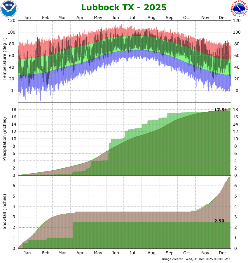
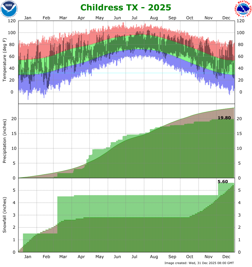
The upper section of the below graph shows the daily high and low temperature distribution for 2025 at Lubbock Preston Smith International Airport. A majority of the year yielded temperatures at or above average, with 11 of the 12 months finishing warmer than average. The warmest months, with respect to average, occurred in December (+9.1°F), November (+7.2°F), October (+6.4°F) and March (+5.1°F), resulting in a warm/hot fall. January (-3.6°F), punctuated by two separate intrusions of Arctic air, was the lone month to finish cooler than average in 2025. February (+0.7) also experienced a couple shots of cold air, including the coldest afternoon of the year on February 19th when the high temperature only reached 23 degrees. Early April and early May also provided cooler-than-average stretches, with much of rest of the year dominated by near to above average temperatures.
The middle section of the chart above shows how much rain accumulated through 2025. Lubbock finished with a grand total of 17.51 inches, or 0.82 inches below the 30-year average. Rainfall the first 3+ months was nearly nonexistent. Much of April into early May brought periodic rainfall, including nearly 2 inches of rain in early May that raised the year-to-date value to around the average of 4 inches. Then it turned dry for nearly a month, with only 0.18 inches falling from May 7th through June 4th, which is typically a wetter time of year. Thankfully, rainfall surged after that, punctuated by severe thunderstorms that dropped 1.95 inches on May 5th and 2.70 inches on May 6th. Periodic showers and thunderstorms continued through summer and into early fall before largely shutting off in mid-September. Dry conditions persisted through October, November and December, causing the final yearly total to fall just below average after residing on the positive side of normal from early June until late November. As opposed to the previous year(s), the well-timed and relatively regular rainfall during the warm/hot season, in combination with the relatively cool summer (at least in comparison to 2025), aided the farmers and ranchers across the region. The warm and dry fall also aided in the harvest.
Similar to the past few years, snow was tough to come by in 2025. The year saw a total of 2.5 inches of snow, including a daily record of 1.5 inches of heavy wet snow which fell on April 5th. This late-season snow was one of the latest measurable snows on record, falling only a week earlier than the latest snow on record (1.4 inches on April 12, 1980). The end of 2025 brought only trace amounts of snow to Lubbock, observed late on December 3rd into the early hours of the 4th.
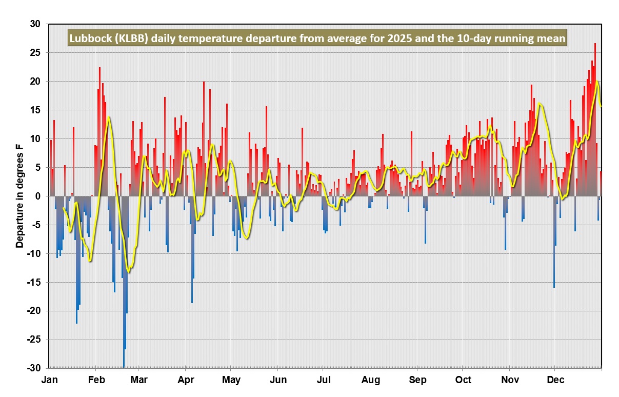
The graph above displays the daily temperature as the departure from the "normal", or 30-year average temperature. The yellow line represents the 10-day running mean of the daily temperature departure and is used to smooth out the day-to-day extremes so that longer trends are easier to see. The two biggest stretches of below average temperatures occurred the second half of January and mid-late February, with a couple of smaller cool stretches in early April and early May. The most notable trend is the nearly continuous above average temperatures from mid-summer through fall and the start of winder, including exceptionally warm periods in early February, mid-November and mid-late December. Overall, the average temperature of 64.7°F degrees for the entire year was 3.3°F above the 30-year average, and made for the 2nd warmest year in the historical record for Lubbock. |
|
|
| JANUARY through DECEMBER |

