|
Historic wind, thick blowing dust and critical fire weather |
|
 |
|
|
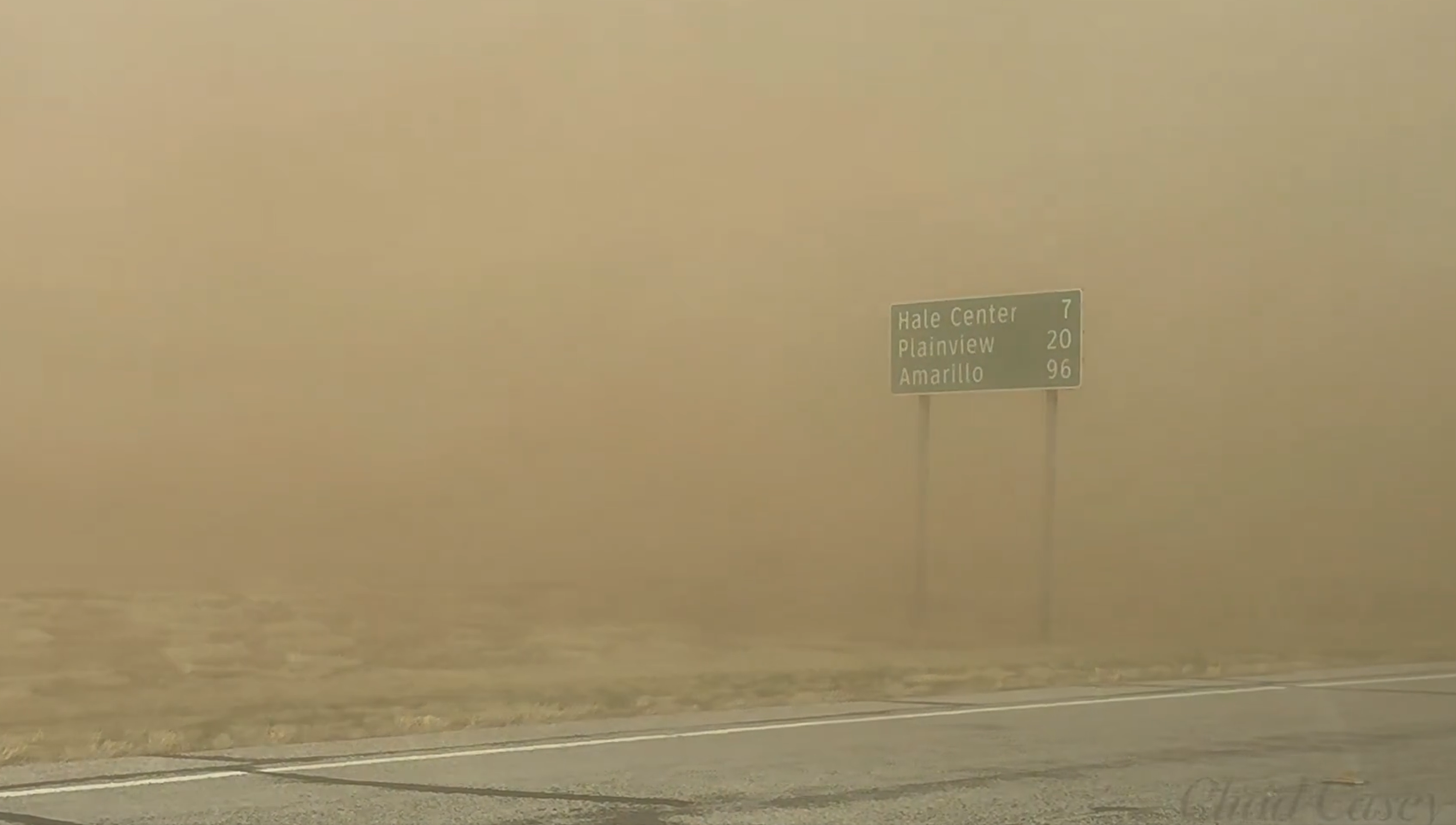
Thick blowing dust near Hale Center on Friday (14 March 2025). The picture is courtesy of Chad Casey. |
|
|
An intense cyclone emerging over the southern High Plains on Friday (14 March 2025) brought high-impact weather to the entire region. This included very strong winds, thick blowing dust, severe thunderstorms, precipitation and extremely critical fire weather. |
|
 |
|
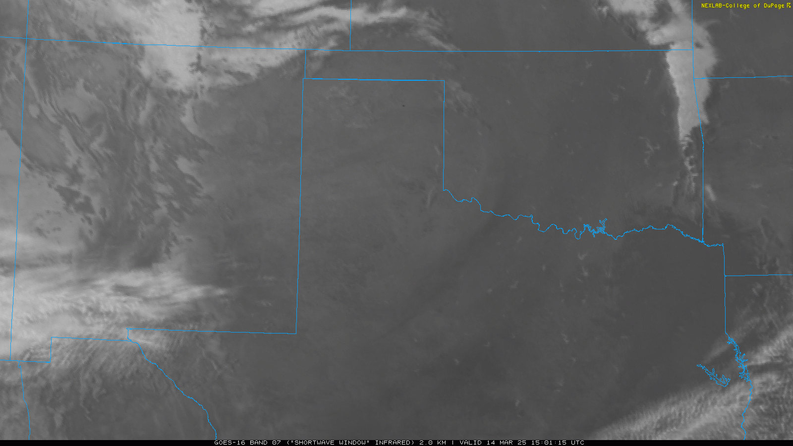
| Water vapor satellite loop valid from 6:11 am to 3:31 pm on Friday (14 March 2025). | |
| The South Plains, Rolling Plains and southern Texas Panhandle was positioned on the south side of the rapidly strengthening storm system, an ideal location for intense westerly winds. On this day, the winds did not disappoint. After a breezy overnight leading into Friday, a Pacific cold front raced from west-to-east across the region during the early morning hours. | |
 |
|
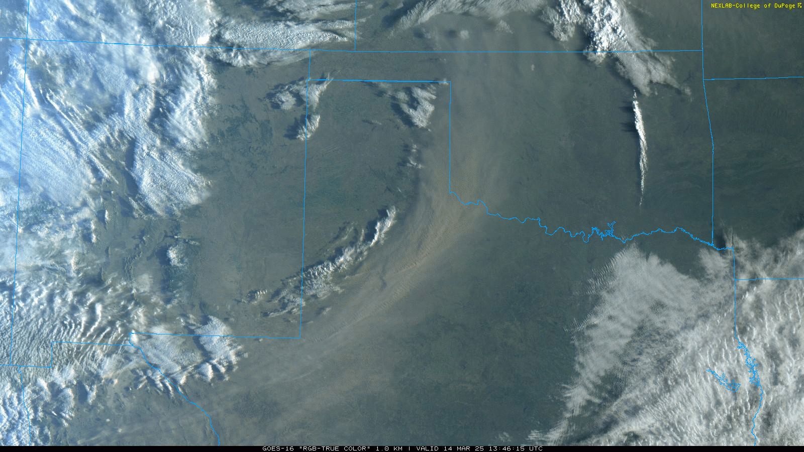
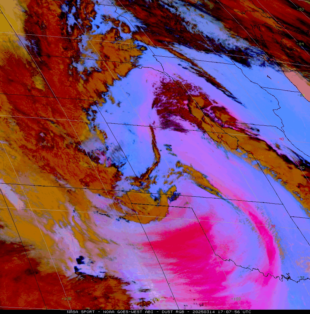
| "RGB-True Color" satellite loop valid from 8:46 am to 6:56 pm on Friday (14 March 2025). A larger regional satellite loop can be VIEWED HERE. | |
| Severe-caliber wind gusts (58 mph or stronger) advanced out of eastern New Mexico and quickly across the Caprock and Rolling Plains Friday morning. Many locations recorded wind gusts of 60 to 70+ mph, which was accompanied by a brief bout of thick blowing dust. As the above animation illustrates, the initial round of dust moved shifted quickly off into Oklahoma and North Texas. However, this was just foreshadowing of what was about to come. | |
 |
|
| Accident near Hale Center on Friday (14 March 2025). The picture is courtesy of Chad Casey. | |
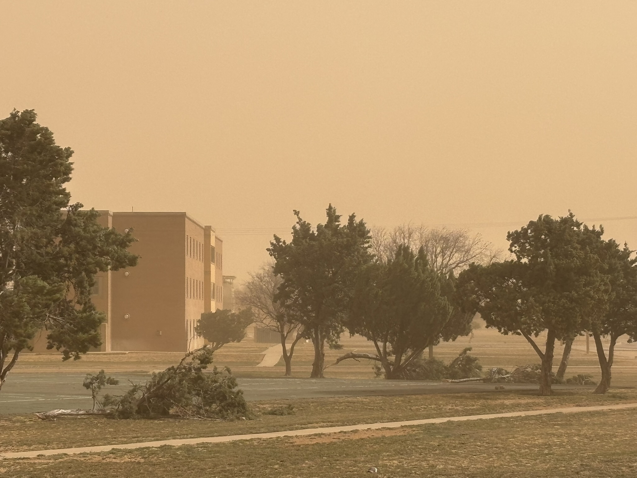
| Even more intense westerly winds evolved over the region through the mid-late morning hours and continued through most of the afternoon before finally easing in the evening. The widespread and long-duration intense wind storm picked up copious amounts of dust from eastern New Mexico and the South Plains region, creating a thick shroud of dust that dropped the visibility to a half mile or less. Many locations, particularly downwind of open fields and construction sites, experienced brownout conditions, making travel extremely hazardous. | |
 |
|
| Geocolor (RGB) satellite loop valid from 2:59 pm to 3:14 pm on Friday (14 March 2025). An additional larger regional satellite image displaying a Dust RGB valid from 12:07 pm to 12:26 pm on Friday can be FOUND HERE. | |
| Unfortunately, the limited visibility did contribute to numerous accidents across the region. This included high profile vehicles, including 18-wheelers, that were tumbled by the wind. The wind also caused significant tree and property damage across the region, while the thick dust created respiratory issues for those that ventured out in it. | |
 |
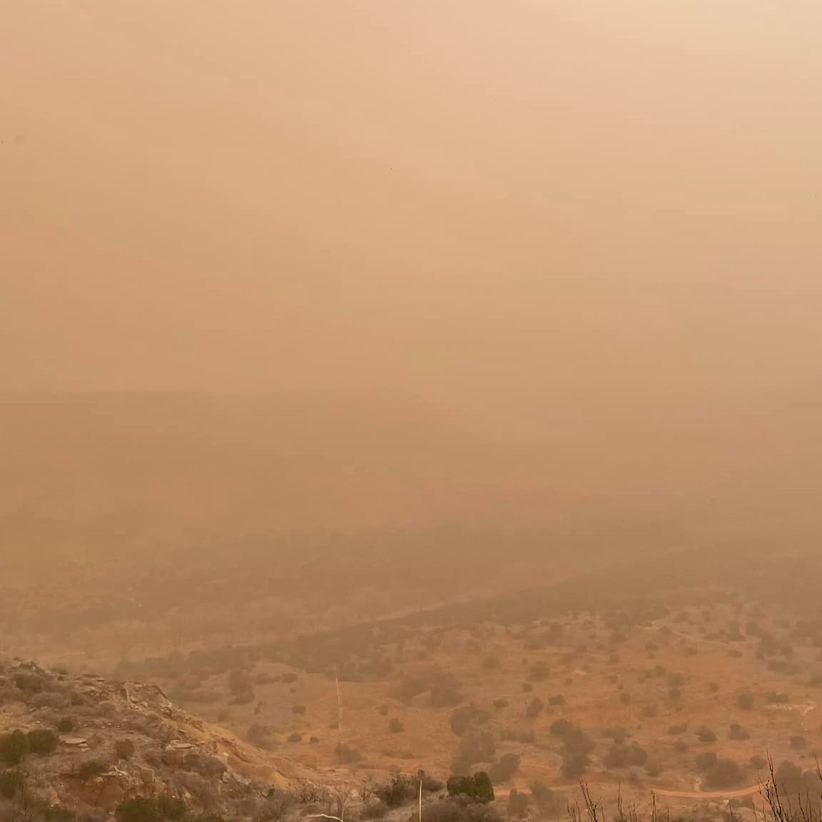 |
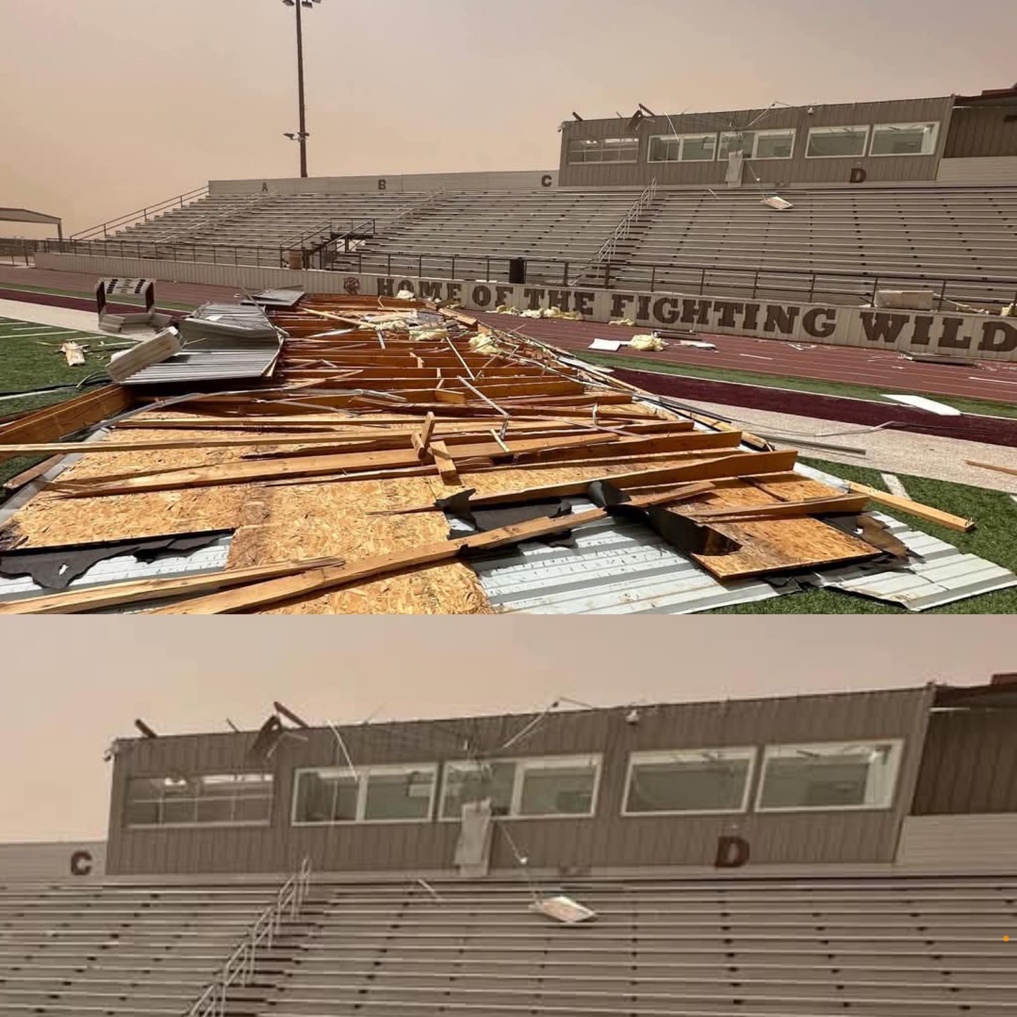
| (left) Damage sustained to the Littlefield Football Stadium on Friday (14 March 2025). The picture is courtesy of Pete Christy. (right) Dusty scene overlooking Palo Duro Canyon on Friday. The image is courtesy of TPWD. | |
|
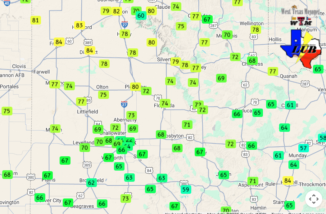
Over the course of the windy Friday, peak wind gusts of 65 to 75 mph were common. Several locations, primarily over the northern South Plains and southern Texas Panhandle, experienced gusts as high as 75 to 85 mph! Peak wind gusts measured within the Lubbock Forecast Area included 84 mph at the Friona and Dimmitt West Texas Mesonet (WTM) sites. |
|
 |
|
| Peak wind gusts measured on Friday (14 March 2025). The data are courtesy of the West Texas Mesonet (WTM). The peak wind speeds on Friday, as measured by the WTM, can be VIEWED HERE. | |
| Just as impressive, peak sustained wind speeds of 50 to 65 mph were measured over most of the area on Friday. Also, the duration of the intense winds was incredible. Many spots experience 60 to 120 minutes (1 to 2 hours) when the wind was gusting over 58 mph. The Amherst WTM was the winner (or loser, depending on your point of view), recording 201 minutes with wind gusts at or above 58 mph on Friday. | |
 |
 |
| Pictures of damage sustained in Dimmitt on Friday (14 March 2025). The pictures are courtesy of Benjamin Elmore. | |
|
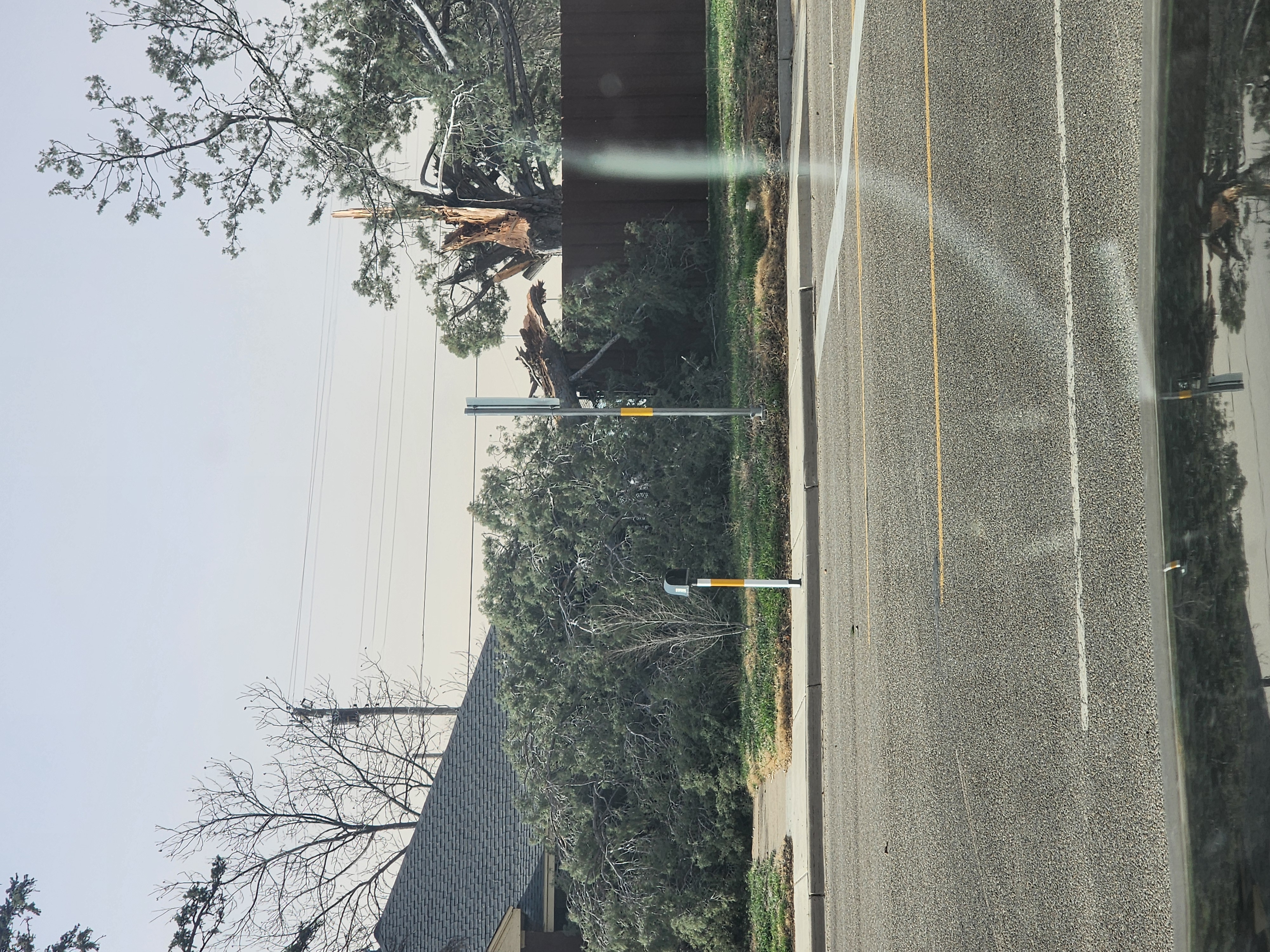
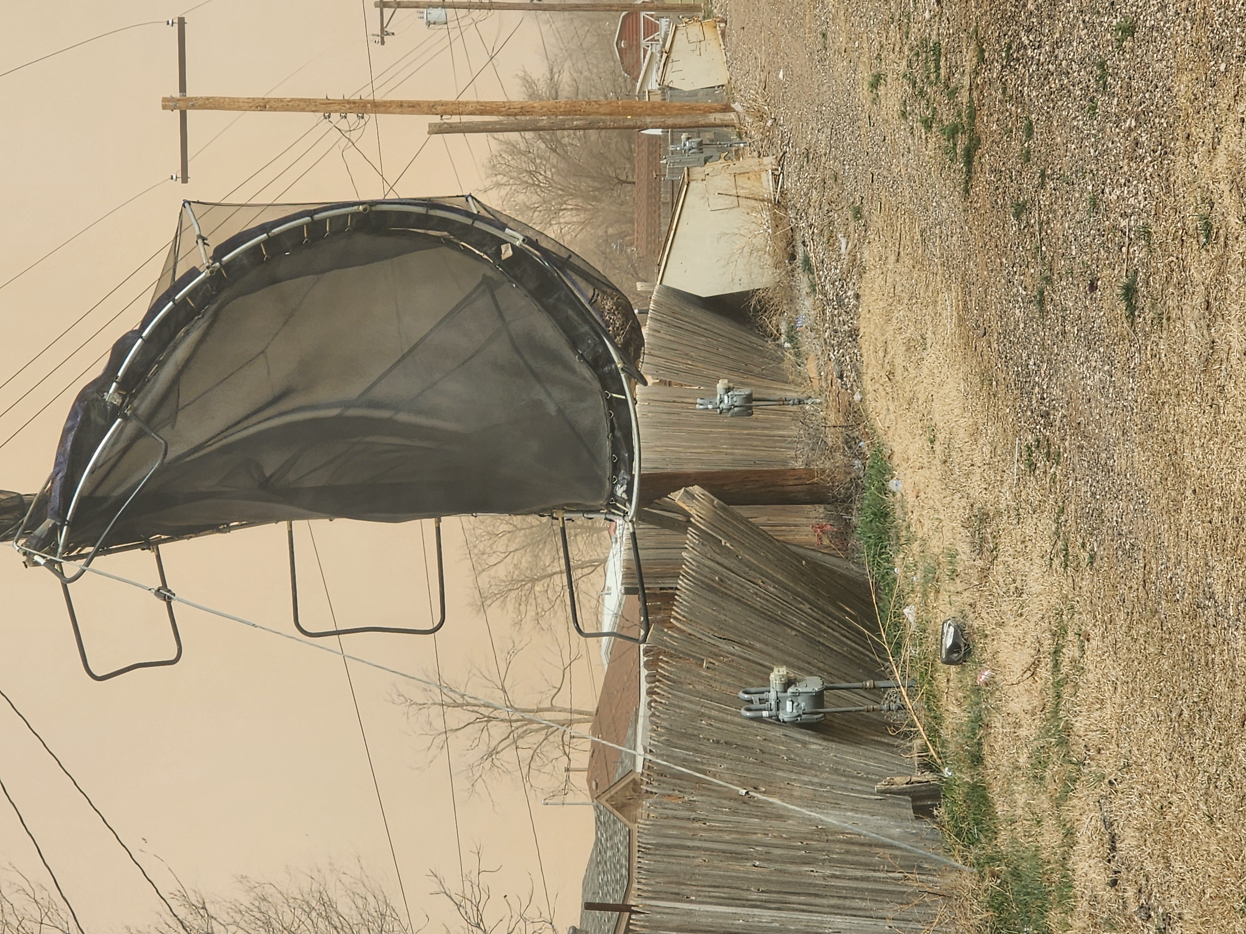
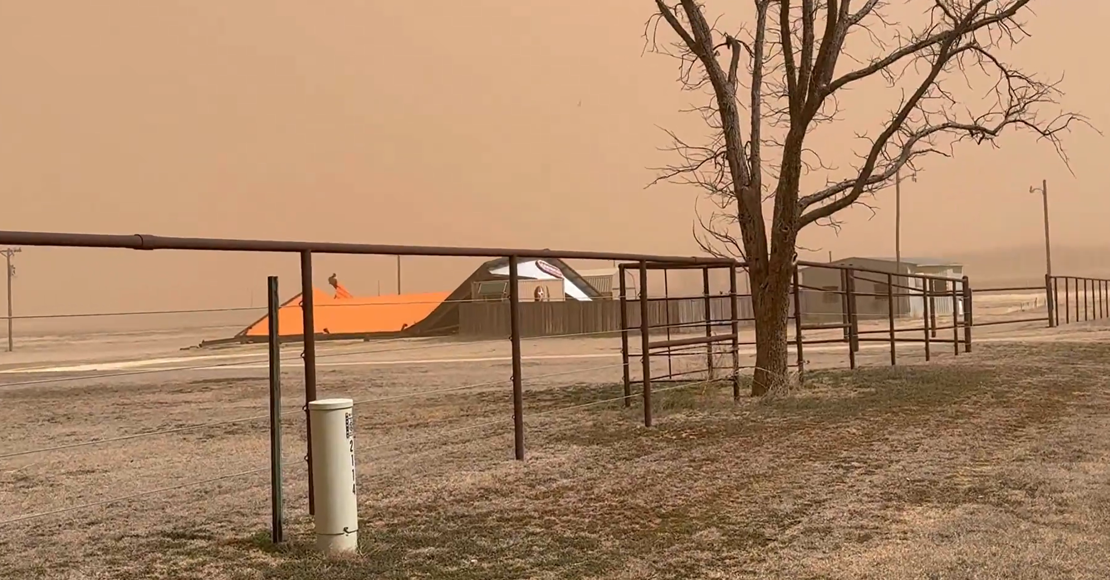
Unfortunately, the intensity and duration of the winds did cause significant damage around the region, as the above and below pictures demonstrate. Officially, the Lubbock Airport recorded a peak wind gust of 82 mph, measured at 1:23 pm, which is the highest wind gust on record for the spring (March, April, May period) dating back to 1945. |
|
 |
|
| Damage to a building south of Plainview on Friday (14 March 2025). The image is courtesy of Chad Casey. | |
|
The wind and blowing dust weren't the only impact to the region. The intense dry winds also supported the rapid development and spread of wildfires, primarily across eastern parts of the Texas Panhandle into central Oklahoma. A couple of wildfires ignited further south too, but thankfully, they were able to be extinguished relatively quickly. |
|
 |
|
| Infrared satellite loop valid from 10:01 am to 8:21 pm on Friday (14 March 2025). The dark spots are "hotspots" where wildfires are ongoing. | |
| Even farther east, where low-level moisture was available, the dynamic storm system generated many severe, some which became tornadic, over the central and southern Mississippi River Valley. One storm also produced a swath of severe-caliber hail over parts of Central and East Texas, from east of Austin through College Station and on to Shreveport, LA. | |
 |
|
| Considerable tree damage at Reese Center on Friday (14 March 2025). The picture is courtesy of Eric Bruning. | |
|
A list of the preliminary storm reports collected over this historically windy day can be found below. |
|
Preliminary Local Storm Report...Summary
National Weather Service Lubbock TX
828 PM CDT Fri Mar 14 2025
..TIME... ...EVENT... ...CITY LOCATION... ...LAT.LON...
..DATE... ....MAG.... ..COUNTY LOCATION..ST.. ...SOURCE....
..REMARKS..
0830 AM Non-Tstm Wnd Gst Caprock Canyons State P 34.41N 101.07W
03/14/2025 M64 MPH Briscoe TX Mesonet
This is the first severe caliber wind gust
of the day.
0859 AM Non-Tstm Wnd Gst 1 E Happy 34.74N 101.84W
03/14/2025 M65 MPH Swisher TX Mesonet
This is the first severe caliber gust of the
day.
0902 AM Non-Tstm Wnd Gst 2 S Lesley 34.65N 100.81W
03/14/2025 M61 MPH Hall TX Mesonet
This is the first severe weather gust of the
day.
0913 AM Non-Tstm Wnd Gst 1 NW Lake Alan Henry 33.08N 101.06W
03/14/2025 M58 MPH Garza TX Mesonet
This is the first severe weather gust of the
day.
0914 AM Non-Tstm Wnd Gst 2 NE Friona 34.65N 102.69W
03/14/2025 M70 MPH Parmer TX Mesonet
This is the peak gusts of the day, to this
point. It is associated with the third
period of severe caliber gusts recorded this
morning. The first severe gust occurred at
5:38 am.
0921 AM Non-Tstm Wnd Gst 4 SW Matador 33.99N 100.90W
03/14/2025 M62 MPH Motley TX Mesonet
This is the first severe caliber wind gust
of the day.
0927 AM Non-Tstm Wnd Gst 1 NW Lake Alan Henry 33.08N 101.06W
03/14/2025 M59 MPH Garza TX Mesonet
Peak wind gust measured through 1:30 PM.
0933 AM Non-Tstm Wnd Gst 3 ENE South Plains 34.24N 101.26W
03/14/2025 M58 MPH Floyd TX Mesonet
This is the first severe caliber gust of the
day.
0945 AM Non-Tstm Wnd Gst 2 NE Dimmitt 34.57N 102.29W
03/14/2025 M71 MPH Castro TX Mesonet
Highest wind gust to this point today.
0952 AM Non-Tstm Wnd Gst 2 ENE Tulia 34.54N 101.74W
03/14/2025 M71 MPH Swisher TX Mesonet
Peak wind gust observed through 10:15 am
today.
0952 AM Non-Tstm Wnd Gst Vigo Park 34.65N 101.50W
03/14/2025 M75 MPH Swisher TX Mesonet
This is the peak wind gust measured through
10 am.
0954 AM Non-Tstm Wnd Gst 4 E Lubbock 33.59N 101.78W
03/14/2025 M60 MPH Lubbock TX Mesonet
This is the first severe caliber wind gust
of the day.
0955 AM Non-Tstm Wnd Gst 4 W Childress 34.43N 100.28W
03/14/2025 M64 MPH Childress TX ASOS
0957 AM Non-Tstm Wnd Gst 3 N Hart 34.42N 102.11W
03/14/2025 M70 MPH Castro TX Mesonet
This is the peak wind gust measured through
10 AM.
0958 AM Non-Tstm Wnd Gst 7 ESE Silverton 34.45N 101.19W
03/14/2025 M71 MPH Briscoe TX Mesonet
This is the peak wind gust measured through
10:15 AM.
1000 AM Non-Tstm Wnd Dmg Dimmitt 34.55N 102.31W
03/14/2025 Castro TX Law Enforcement
Relayed report of a tree sheared off within
town. Time and location of the damage are
estimated. Visibility in town was around 2
miles because of blowing dust.
1005 AM Non-Tstm Wnd Gst 4 SE Lubbock 33.54N 101.81W
03/14/2025 M60 MPH Lubbock TX Mesonet
First severe caliber gust of the day.
1010 AM Non-Tstm Wnd Gst 2 SSE Plainview 34.17N 101.72W
03/14/2025 M61 MPH Hale TX AWOS
This is the peak wind gust measured through
10:30 AM. Visibility is also down to 2 miles
from blowing dust.
1012 AM Non-Tstm Wnd Gst 6 S Olton 34.09N 102.12W
03/14/2025 M70 MPH Lamb TX Mesonet
This is the peak wind gust measured through
10:20 AM.
1020 AM Dust Storm 8 N Dimmitt 34.66N 102.32W
03/14/2025 Castro TX Law Enforcement
Reports of brownout conditions between
Dimmitt and Hereford.
1021 AM Non-Tstm Wnd Gst 3 N Roaring Springs 33.94N 100.85W
03/14/2025 M72 MPH Motley TX Mesonet
Peak wind gust measured through 12:55 PM.
1027 AM Non-Tstm Wnd Gst Caprock Canyons State P 34.41N 101.07W
03/14/2025 M71 MPH Briscoe TX Mesonet
This is the peak wind gust measured through
10:30 AM.
1033 AM Non-Tstm Wnd Gst 10 WSW Guthrie 33.57N 100.48W
03/14/2025 M61 MPH King TX Mesonet
1034 AM Non-Tstm Wnd Gst 2 SSW Muleshoe 34.21N 102.74W
03/14/2025 M71 MPH Bailey TX Mesonet
This is the peak wind gust measured through
11:20 AM.
1034 AM Non-Tstm Wnd Gst 6 NW White River Lake 33.53N 101.17W
03/14/2025 M59 MPH Crosby TX Mesonet
This is the peak wind gust measured through
10:40 AM.
1038 AM Non-Tstm Wnd Gst New Home 33.33N 101.91W
03/14/2025 M65 MPH Lynn TX Mesonet
Peak wind gust measured through 1:20 PM.
1040 AM Non-Tstm Wnd Gst 10 SW Paducah 33.89N 100.40W
03/14/2025 M65 MPH Cottle TX Mesonet
This is the peak wind gust measured through
10:40 AM.
1041 AM Non-Tstm Wnd Gst 2 NE Dimmitt 34.57N 102.29W
03/14/2025 M78 MPH Castro TX Mesonet
This is the peak wind gust measured through
11:10 AM.
1041 AM Non-Tstm Wnd Gst 1 W Spur 33.48N 100.88W
03/14/2025 M61 MPH Dickens TX Mesonet
This is the peak wind gust measured through
10:45 AM.
1042 AM Non-Tstm Wnd Gst 8 SW Sundown 33.39N 102.61W
03/14/2025 M67 MPH Cochran TX Mesonet
Peak wind gust measured through 1:15 PM.
1043 AM Non-Tstm Wnd Gst 1 NE Post 33.20N 101.37W
03/14/2025 M63 MPH Garza TX Mesonet
Peak wind gust measured through 11:35 AM.
1044 AM Non-Tstm Wnd Gst 3 WNW Lubbock 33.60N 101.90W
03/14/2025 M63 MPH Lubbock TX Mesonet
This is the peak wind gust measured through
10:50 AM.
1045 AM Non-Tstm Wnd Gst 2 S Brownfield 33.15N 102.27W
03/14/2025 M62 MPH Terry TX Mesonet
Peak wind gust measured through 1:30 PM.
1045 AM Non-Tstm Wnd Gst Reese Center 33.61N 102.05W
03/14/2025 M68 MPH Lubbock TX Mesonet
Peak wind gust measured through 1:10 PM.
1045 AM Non-Tstm Wnd Gst 7 ESE Silverton 34.45N 101.19W
03/14/2025 M77 MPH Briscoe TX Mesonet
This is the peak wind gust measured through
11:10 AM.
1046 AM Non-Tstm Wnd Gst 4 SW Matador 33.99N 100.90W
03/14/2025 M71 MPH Motley TX Mesonet
Peak wind gust measured through 1 PM.
1046 AM Non-Tstm Wnd Gst 3 NE Aspermont 33.17N 100.20W
03/14/2025 M62 MPH Stonewall TX Mesonet
This is the peak wind gust measured through
10:50 AM.
1047 AM Non-Tstm Wnd Gst 3 NNE Tahoka 33.21N 101.78W
03/14/2025 M63 MPH Lynn TX Mesonet
Peak wind gust measured through 11:50 AM.
1048 AM Non-Tstm Wnd Dmg 3 WSW Lubbock 33.57N 101.89W
03/14/2025 Lubbock TX Fire Dept/Rescue
Tree fallen on garage near 31st Street and
Knoxville Avenue in Lubbock.
1048 AM Non-Tstm Wnd Gst 2 SSE Hackberry 33.90N 100.13W
03/14/2025 M63 MPH Cottle TX Mesonet
This is the peak wind gust measured through
11 AM.
1049 AM Non-Tstm Wnd Gst 6 NW White River Lake 33.53N 101.17W
03/14/2025 M67 MPH Crosby TX Mesonet
Peak wind gust measured through 1:15 PM.
1049 AM Non-Tstm Wnd Gst 6 SSW Anton 33.73N 102.19W
03/14/2025 M69 MPH Hockley TX Mesonet
Peak wind gust measured through 1:05 PM.
1049 AM Non-Tstm Wnd Gst 4 SSE Estelline 34.50N 100.42W
03/14/2025 M72 MPH Hall TX Mesonet
This is the peak wind gust measured through
11:05 AM.
1050 AM Non-Tstm Wnd Gst 2 SSE Plainview 34.17N 101.72W
03/14/2025 M63 MPH Hale TX AWOS
Peak wind gust measured through 12:30 PM.
Visibility has fallen as low at 1.25 miles
from blowing dust.
1053 AM Non-Tstm Wnd Gst 9 SW Earth 34.19N 102.56W
03/14/2025 M73 MPH Lamb TX Mesonet
This is the peak wind gust measured through
11:15 AM.
1054 AM Non-Tstm Wnd Gst 2 NNE Childress 34.46N 100.20W
03/14/2025 M65 MPH Childress TX Mesonet
This is the peak wind gust measured through
11 AM.
1055 AM Non-Tstm Wnd Gst 2 NE Friona 34.65N 102.69W
03/14/2025 M78 MPH Parmer TX Mesonet
This is the peak wind gust measured through
11:10 AM.
1057 AM Non-Tstm Wnd Dmg 5 ENE Wolfforth 33.53N 101.93W
03/14/2025 Lubbock TX Local Official
Tree uprooted and blocking portion of the
road near 73rd Street and Chicago Avenue in
Lubbock.
1057 AM Non-Tstm Wnd Gst 1 E Happy 34.74N 101.84W
03/14/2025 M78 MPH Swisher TX Mesonet
This is the peak wind gust measured through
11:10 AM.
1101 AM Non-Tstm Wnd Gst 1 SSE Jayton 33.23N 100.57W
03/14/2025 M65 MPH Kent TX Mesonet
This is the peak wind gust measured through
11:05 AM.
1102 AM Non-Tstm Wnd Gst 2 SSE Hackberry 33.90N 100.13W
03/14/2025 M64 MPH Cottle TX Mesonet
Peak wind gust measured through 1:30 PM.
1102 AM Non-Tstm Wnd Gst 3 NE Aspermont 33.17N 100.20W
03/14/2025 M71 MPH Stonewall TX Mesonet
Peak wind gust measured through 1 PM.
1103 AM Non-Tstm Wnd Gst 5 SSW Graham 33.08N 101.52W
03/14/2025 M65 MPH Garza TX Mesonet
Peak wind gust measured through 1:25 PM.
1104 AM Non-Tstm Wnd Dmg 1 NNE Lubbock 33.60N 101.84W
03/14/2025 Lubbock TX Local Official
Semi-truck flipped by strong winds near
Municipal Drive and Interstate 27 in
Lubbock.
1104 AM Non-Tstm Wnd Gst 3 N Hart 34.42N 102.11W
03/14/2025 M74 MPH Castro TX Mesonet
This is the peak wind gust measured through
11:15 AM.
1104 AM Non-Tstm Wnd Gst 2 ENE Tulia 34.54N 101.74W
03/14/2025 M76 MPH Swisher TX Mesonet
This is the peak wind gust measured through
11:15 AM.
1113 AM Non-Tstm Wnd Gst 2 WSW Turkey 34.38N 100.93W
03/14/2025 M73 MPH Hall TX Mesonet
This is the peak wind gust measured through
11:20 AM.
1113 AM Non-Tstm Wnd Gst 2 S Lesley 34.65N 100.81W
03/14/2025 M77 MPH Hall TX Mesonet
This is the peak wind gust measured through
11:20 AM.
1115 AM Dust Storm 2 SSW Levelland 33.55N 102.37W
03/14/2025 Hockley TX AWOS
1115 AM Non-Tstm Wnd Gst 6 S Wolfforth 33.42N 102.05W
03/14/2025 M67 MPH Lubbock TX Mesonet
Peak wind gust measured through 11:50 AM.
1115 AM Dust Storm 2 SSW Levelland 33.55N 102.37W
03/14/2025 Hockley TX AWOS
Reporting 1/4 mile visibility because of
blowing dust. Wind is also gusting up to 56
knots.
1122 AM Non-Tstm Wnd Gst 2 NE Friona 34.65N 102.69W
03/14/2025 M81 MPH Parmer TX Mesonet
This is the peak wind gust measured through
11:25 AM.
1124 AM Non-Tstm Wnd Gst 3 WNW Lubbock 33.60N 101.90W
03/14/2025 M64 MPH Lubbock TX Mesonet
Peak wind gust measured through 1:25 PM.
1129 AM Non-Tstm Wnd Gst 9 SW Earth 34.19N 102.56W
03/14/2025 M74 MPH Lamb TX Mesonet
Peak wind gust measured through 12:50 PM.
1131 AM Non-Tstm Wnd Gst 4 SE Lubbock 33.54N 101.81W
03/14/2025 M64 MPH Lubbock TX Mesonet
Peak wind gust measured through 1:25 PM.
1135 AM Non-Tstm Wnd Gst 8 SE Guthrie 33.55N 100.21W
03/14/2025 M64 MPH King TX Mesonet
Peak wind gust measured through 11:45 AM.
1136 AM Non-Tstm Wnd Gst 4 E Lubbock 33.59N 101.78W
03/14/2025 M66 MPH Lubbock TX Mesonet
Peak wind gust measured through 1:20 PM.
1140 AM Non-Tstm Wnd Dmg 3 WSW Lubbock 33.57N 101.88W
03/14/2025 Lubbock TX Local Official
Tree down on the roadway near 30th Street
and Gary Avenue in Lubbock.
1141 AM Non-Tstm Wnd Gst 10 WSW Guthrie 33.57N 100.48W
03/14/2025 M69 MPH King TX Mesonet
Peak wind gust measured through 1:10 PM.
1146 AM Non-Tstm Wnd Gst 6 E New Deal 33.73N 101.74W
03/14/2025 M69 MPH Lubbock TX Mesonet
Peak wind gust measured through 1:05 PM.
1150 AM Non-Tstm Wnd Gst 3 ENE South Plains 34.24N 101.26W
03/14/2025 M72 MPH Floyd TX Mesonet
Peak wind gust measured through 12:55 PM.
1157 AM Non-Tstm Wnd Gst 2 NE Dimmitt 34.57N 102.29W
03/14/2025 M82 MPH Castro TX Mesonet
Peak wind gust measured through 12:35 PM.
1200 PM Non-Tstm Wnd Dmg Dimmitt 34.55N 102.32W
03/14/2025 Castro TX Law Enforcement
Relayed report of widespread damage to trees
and sheds and other out buildings around
Dimmitt.
1201 PM Non-Tstm Wnd Gst 2 NE Friona 34.65N 102.69W
03/14/2025 M84 MPH Parmer TX Mesonet
Peak wind gust measured through 12:35 AM.
1203 PM Non-Tstm Wnd Gst Smyer 33.59N 102.17W
03/14/2025 M70 MPH Hockley TX Mesonet
Peak wind gust measured through 1:05 PM.
1203 PM Non-Tstm Wnd Gst 2 E Flomot 34.23N 100.96W
03/14/2025 M70 MPH Motley TX Mesonet
Peak wind gust measured through 1:05 PM.
1204 PM Non-Tstm Wnd Gst 4 W Childress 34.43N 100.28W
03/14/2025 M71 MPH Childress TX ASOS
Peak wind gust measured through 3:35 PM.
1209 PM Non-Tstm Wnd Gst 1 S Northfield 34.27N 100.60W
03/14/2025 M68 MPH Motley TX Mesonet
Peak wind gust measured through 12:20 PM.
1212 PM Non-Tstm Wnd Gst 3 N Plains 33.23N 102.84W
03/14/2025 M67 MPH Yoakum TX Mesonet
Peak wind gust measured through 1:15 PM.
1213 PM Non-Tstm Wnd Gst 4 S Levelland 33.53N 102.36W
03/14/2025 M70 MPH Hockley TX Mesonet
Peak wind gust measured through 1:05 PM.
1213 PM Non-Tstm Wnd Gst 1 S Plainview 34.18N 101.71W
03/14/2025 M73 MPH Hale TX Mesonet
Peak wind gust measured through 12:50 PM.
1213 PM Non-Tstm Wnd Gst 6 S Olton 34.09N 102.12W
03/14/2025 E75 MPH Lamb TX Mesonet
Peak wind gust measured through 12:45 PM.
1215 PM Non-Tstm Wnd Dmg 3 NW Woodrow 33.48N 101.89W
03/14/2025 Lubbock TX Law Enforcement
Power line in the lanes of traffic at 130th
Street and Indiana Avenue in Lubbock.
1216 PM Non-Tstm Wnd Gst Vigo Park 34.65N 101.50W
03/14/2025 M78 MPH Swisher TX Mesonet
Peak wind gust measured through 12:40 PM.
1217 PM Non-Tstm Wnd Gst 2 SSW Muleshoe 34.21N 102.74W
03/14/2025 M77 MPH Bailey TX Mesonet
Peak wind gust measured through 12:40 PM.
1217 PM Non-Tstm Wnd Gst 3 N Hart 34.42N 102.11W
03/14/2025 M78 MPH Castro TX Mesonet
Peak wind gust measured through 12:40 PM.
1219 PM Non-Tstm Wnd Gst 6 W Lubbock 33.57N 101.94W
03/14/2025 M68 MPH Lubbock TX Mesonet
Peak wind gust measured through 1:10 PM.
1220 PM Non-Tstm Wnd Dmg 1 NW Hart 34.39N 102.12W
03/14/2025 Castro TX Law Enforcement
Power pole reported to be wrapped around a
vehicle near Hart. Exact location and time
of incident unknown.
1220 PM Dust Storm 8 SE Dimmitt 34.47N 102.22W
03/14/2025 Castro TX Law Enforcement
Highway 194 has been closed between Dimmitt
and Hart because of strong winds and near
zero visibility from blowing dust.
1220 PM Dust Storm Dimmitt 34.55N 102.31W
03/14/2025 Castro TX Law Enforcement
Visibility below 1/4 mile due to blowing
dust.
1229 PM Dust Storm 1 NNW Lubbock Int. Airp 33.67N 101.82W
03/14/2025 Lubbock TX ASOS
Visibility of 1/4 mile from blowing dust.
Wind is gusting to 61 knots at the moment.
1231 PM Non-Tstm Wnd Dmg 2 SSW Lubbock 33.55N 101.87W
03/14/2025 Lubbock TX Law Enforcement
Power pole downed near 44th Street and
Avenue X in Lubbock. The downed line sparked
a small fire.
1233 PM Non-Tstm Wnd Gst 6 S Lubbock 33.50N 101.88W
03/14/2025 M64 MPH Lubbock TX Mesonet
Peak wind gust measured through 1:25 PM.
1239 PM Non-Tstm Wnd Gst 3 WSW Aiken 34.13N 101.57W
03/14/2025 M71 MPH Hale TX Mesonet
Peak wind gust measured through 1 PM.
1239 PM Non-Tstm Wnd Gst 2 NE Dimmitt 34.57N 102.29W
03/14/2025 M84 MPH Castro TX Mesonet
Peak wind gust measured through 12:45 PM.
1240 PM Non-Tstm Wnd Gst 7 ESE Silverton 34.45N 101.19W
03/14/2025 M78 MPH Briscoe TX Mesonet
Peak wind gust measured through 12:40 PM.
1241 PM Non-Tstm Wnd Gst 1 NNE Floydada 34.00N 101.33W
03/14/2025 M73 MPH Floyd TX Mesonet
Peak wind gust measured through 12:55 PM.
1243 PM Non-Tstm Wnd Gst 6 ENE Abernathy 33.88N 101.76W
03/14/2025 E71 MPH Hale TX Mesonet
Peak wind gust measured through 1 PM.
1244 PM Non-Tstm Wnd Dmg 5 E Reese Center 33.59N 101.95W
03/14/2025 Lubbock TX Public
Tree downed near Hyden Avenue and Huron
Avenue.
1246 PM Non-Tstm Wnd Gst 1 W Spur 33.48N 100.88W
03/14/2025 M62 MPH Dickens TX Mesonet
Peak wind gust measured through 1:30 PM.
1251 PM Non-Tstm Wnd Gst Vigo Park 34.65N 101.50W
03/14/2025 M80 MPH Swisher TX Mesonet
Peak wind gust measured through 2:35 PM.
1256 PM Non-Tstm Wnd Gst 3 NNW Mcadoo 33.77N 101.04W
03/14/2025 M68 MPH Dickens TX Mesonet
Peak wind gust measured through 1:15 PM.
1257 PM Non-Tstm Wnd Dmg 1 WSW Lubbock 33.58N 101.86W
03/14/2025 Lubbock TX Public
Downed tree near 16th Street and Avenue V in
Lubbock.
0101 PM Non-Tstm Wnd Gst 2 NNE Childress 34.46N 100.20W
03/14/2025 M66 MPH Childress TX Mesonet
Peak wind gust measured through 1:20 PM.
0101 PM Non-Tstm Wnd Gst 1 SE Ralls 33.67N 101.38W
03/14/2025 M68 MPH Crosby TX Mesonet
Peak wind gust measured through 1:15 PM.
0104 PM Non-Tstm Wnd Gst 2 WSW Turkey 34.38N 100.93W
03/14/2025 M77 MPH Hall TX Mesonet
Peak wind gust measured through 2:40 PM.
0107 PM Non-Tstm Wnd Gst 1 NE Memphis 34.73N 100.53W
03/14/2025 M70 MPH Hall TX Mesonet
Peak wind gust measured through 3 PM.
0107 PM Non-Tstm Wnd Gst 2 E Flomot 34.23N 100.96W
03/14/2025 M70 MPH Motley TX Mesonet
0109 PM Non-Tstm Wnd Gst 2 NE Slaton 33.46N 101.62W
03/14/2025 M66 MPH Lubbock TX Mesonet
Peak wind gust measured through 1:20 PM.
0113 PM Non-Tstm Wnd Gst 2 ENE Tulia 34.54N 101.74W
03/14/2025 M78 MPH Swisher TX Mesonet
Peak wind gust measured through 2:40 PM.
0119 PM Non-Tstm Wnd Dmg 5 W Lubbock 33.58N 101.93W
03/14/2025 Lubbock TX Law Enforcement
Downed tree at 18th Street and Chicago
Avenue in Lubbock.
0121 PM Non-Tstm Wnd Gst 1 N O`Donnell 32.98N 101.83W
03/14/2025 M73 MPH Lynn TX Mesonet
Peak wind gust measured through 2:50 PM.
0123 PM Non-Tstm Wnd Gst 1 NNW Lubbock Int. Airp 33.67N 101.82W
03/14/2025 M82 MPH Lubbock TX ASOS
Peak wind gust measured through 3:35 PM.
0128 PM Non-Tstm Wnd Gst 1 ENE Morton 33.73N 102.74W
03/14/2025 M74 MPH Cochran TX Mesonet
Peak wind gust measured through 2:45 PM.
0130 PM Non-Tstm Wnd Dmg 1 NE Matador 34.03N 100.81W
03/14/2025 Motley TX CO-OP Observer
A couple of trees have been blown down. Time
estimated.
0134 PM Non-Tstm Wnd Dmg 2 E Wolfforth 33.51N 101.97W
03/14/2025 Lubbock TX Law Enforcement
Stop sign blown down at 98th Street and
Upland Avenue in Lubbock.
0137 PM Non-Tstm Wnd Gst Caprock Canyons State P 34.41N 101.07W
03/14/2025 M78 MPH Briscoe TX Mesonet
Peak wind gust measured through 2:40 PM.
0141 PM Non-Tstm Wnd Dmg 5 W Lubbock 33.59N 101.92W
03/14/2025 Lubbock TX Public
Roof blown off a portion of The Landing at
Pinewood Park near 4th Street and Slide
Avenue in Lubbock.
0145 PM Non-Tstm Wnd Dmg 2 WSW Lubbock 33.57N 101.87W
03/14/2025 Lubbock TX Fire Dept/Rescue
Fire department responding to a tree fallen
on a power line near 22nd Place and
University Avenue in Lubbock.
0146 PM Non-Tstm Wnd Gst 1 S Plainview 34.18N 101.71W
03/14/2025 M80 MPH Hale TX Mesonet
Peak wind gust measured through 2:35 PM.
0148 PM Non-Tstm Wnd Gst 2 NNE Childress 34.46N 100.20W
03/14/2025 M68 MPH Childress TX Mesonet
Peak wind gust measured through 3 PM.
0148 PM Non-Tstm Wnd Gst 10 WSW Guthrie 33.57N 100.48W
03/14/2025 M72 MPH King TX Mesonet
Peak wind gust measured through 2:50 PM.
0151 PM Non-Tstm Wnd Gst 7 ESE Silverton 34.45N 101.19W
03/14/2025 M79 MPH Briscoe TX Mesonet
Peak wind gust measured through 2:35 PM.
0153 PM Non-Tstm Wnd Gst 3 NNW Mcadoo 33.77N 101.04W
03/14/2025 M71 MPH Dickens TX Mesonet
Peak wind gust measured through 2:55 PM.
0208 PM Non-Tstm Wnd Gst 2 SSE Hackberry 33.90N 100.13W
03/14/2025 M65 MPH Cottle TX Mesonet
Peak wind gust measured through 3:05 PM.
0208 PM Non-Tstm Wnd Gst 4 SW Matador 33.99N 100.90W
03/14/2025 M72 MPH Motley TX Mesonet
Peak wind gust measured through 2:55 PM.
0208 PM Non-Tstm Wnd Gst 3 ENE South Plains 34.24N 101.26W
03/14/2025 M74 MPH Floyd TX Mesonet
Peak wind gust measured through 2:45 PM.
0215 PM Non-Tstm Wnd Dmg 5 NW Lubbock 33.63N 101.91W
03/14/2025 Lubbock TX Public
Picture of a metal roof taken off an
industrial building along Highway 84 between
Lubbock and Shallowater. The location is
estimated.
0218 PM Non-Tstm Wnd Gst 3 WSW Aiken 34.13N 101.57W
03/14/2025 M72 MPH Hale TX Mesonet
Peak wind gust measured through 2:50 PM.
0221 PM Non-Tstm Wnd Gst 1 W Spur 33.48N 100.88W
03/14/2025 M64 MPH Dickens TX Mesonet
Peak wind gust measured through 3:05 PM.
0227 PM Non-Tstm Wnd Gst 8 SE Guthrie 33.55N 100.21W
03/14/2025 M66 MPH King TX Mesonet
Peak wind gust measured through 3:05 PM.
0230 PM Non-Tstm Wnd Gst 2 SSE Plainview 34.17N 101.72W
03/14/2025 M74 MPH Hale TX AWOS
Peak wind gust measured through 3:10 PM.
Blowing dust was reducing the visibility to
1 mile at the time of the peak gust.
0231 PM Non-Tstm Wnd Gst 1 NNE Floydada 34.00N 101.33W
03/14/2025 M74 MPH Floyd TX Mesonet
Peak wind gust measured through 2:45 PM.
0242 PM Non-Tstm Wnd Gst 6 ENE Abernathy 33.88N 101.76W
03/14/2025 M73 MPH Hale TX Mesonet
Peak wind gust measured through 2:50 PM.
0245 PM Non-Tstm Wnd Gst 6 NW White River Lake 33.53N 101.17W
03/14/2025 M68 MPH Crosby TX Mesonet
Peak wind gust measured through 3 PM.
0249 PM Non-Tstm Wnd Gst 2 E Flomot 34.23N 100.96W
03/14/2025 M74 MPH Motley TX Mesonet
Peak wind gust measured through 3:20 PM.
0256 PM Non-Tstm Wnd Gst 2 NE Slaton 33.46N 101.62W
03/14/2025 M67 MPH Lubbock TX Mesonet
Peak wind gust measured through 3 PM.

