
Tropical Storm Bertha could bring tropical storm conditions to portions of the Florida Panhandle and Alabama coast through Wednesday, where a Tropical Storm Watch and Storm Surge Watch is in effect. Numerous severe thunderstorms with heavy rainfall are expected from the Ohio Valley into the Mid-Atlantic and Northeast Tuesday. Read More >
|
Thunderstorms bring widespread rainfall and scattered severe weather |
|
 |
|
|
Supercell thunderstorm north of Aspermont late Tuesday afternoon (29 April 2025). The picture is courtesy of Austin Christopher. |
|
|
Tuesday, April 29th, brought yet another day of active weather, complete with severe thunderstorms that produced giant hail, damaging winds and torrential rainfall. This marked the 8th straight day of severe weather affecting parts of the South Plains, Rolling Plains or southern Texas Panhandle. This active stretch kicked off April 22nd and 23rd, and ramped up in coverage and intensity April 24th, 25th and 26th. Thunderstorm activity was more isolated April 27th and 28th, but still managed to produce a little severe weather, with hail falling over parts of Lubbock Sunday evening (27 April) and an intense storm clipping the southern Rolling Plains Monday afternoon (28 April). |
|
 |
|
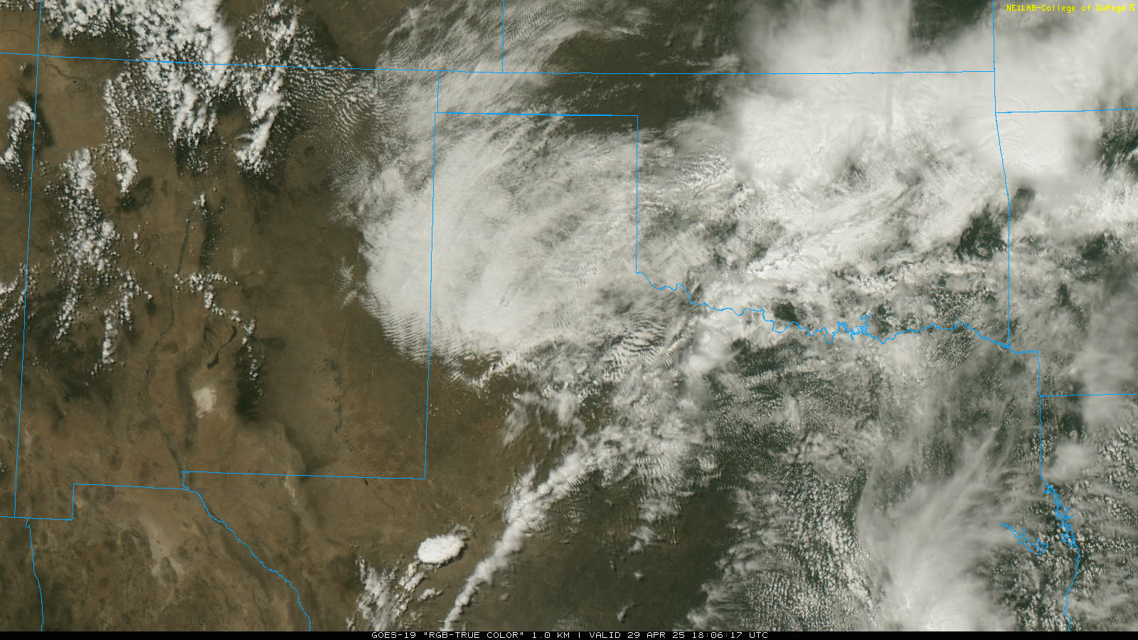
| "RGB-True Color" satellite loop valid from 1:06 pm to 5:36 pm on Tuesday (29 April 2025). | |
|
On Tuesday, thunderstorms erupted along a southward moving cold front over the southern South and Rolling Plains during the afternoon. These storms fed on rich moisture and strong instability south of the front, and quickly started to rotate thanks to abundant vertical wind shear. The most intense storms of the day targeted the southern Rolling Plains as they tracked eastward, bringing large to giant hail, strong winds and intense rainfall. |
|
 |
|
| Supercell thunderstorm near Afton Sunday afternoon (25 May 2025). | |
|
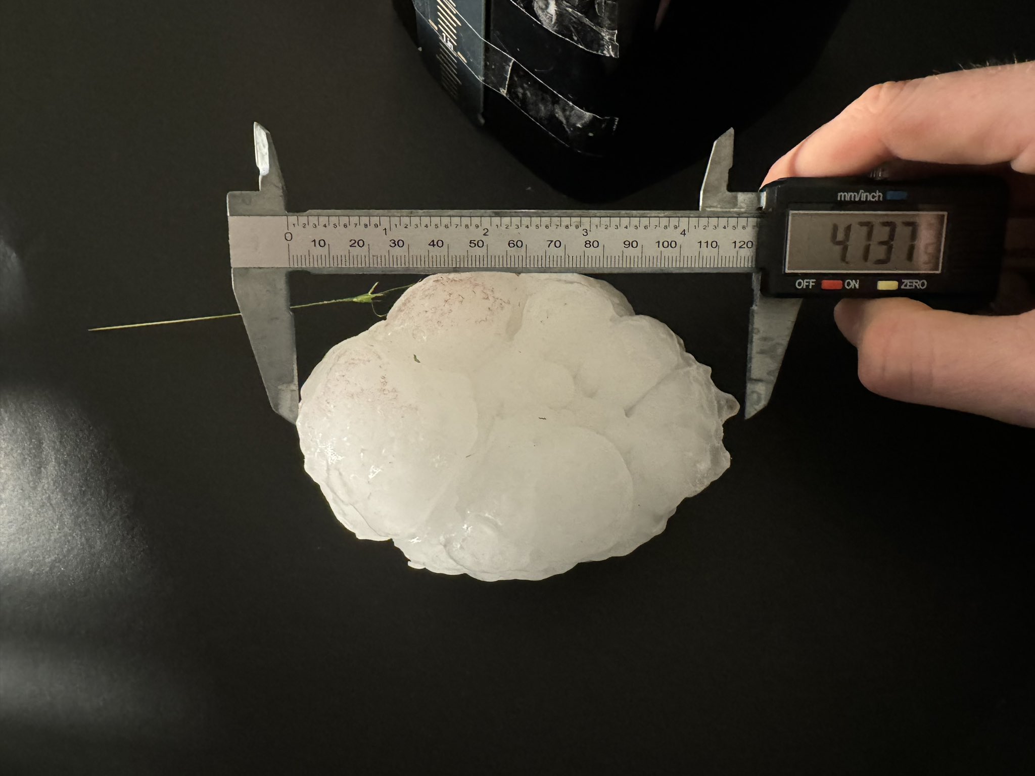
Farther to the southeast, very intense storms brought hail as large as 5 inches in diameter, which was found 12 miles south-southeast of Guthrie. Winds from this activity also blew the roof off a vacant home in Jayton. On the positive side, the cold front continued to move south, undercutting these intensely rotating storms, which likely was the reason they failed to produce any known tornadoes. |
|
 |
|
| Supercell thunderstorm near Post Tuesday afternoon (29 April 2025). The image is courtesy of Jeremy Perez. | |
| The severe weather spread eastward with the storms through Tuesday evening, producing a peak wind gust of 106 mph as it moved by the Seymour West Texas Mesonet (WTM) station located 3 miles northwest of town. Just as impressive, the WTM site recorded 3 gusts of 100 mph or higher, sustained winds of 68 mph or higher for 11 straight minutes and a peak sustained wind speed of 84 mph. | |
 |
|
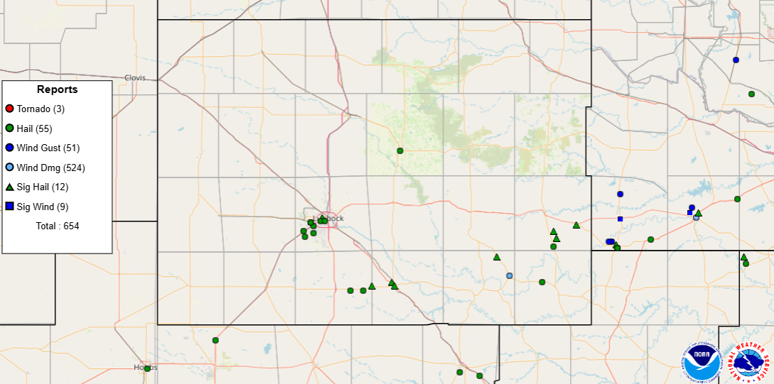
| Preliminary storm reports gathered on Tuesday (29 April 2025). | |
|
The departure of the afternoon thunderstorms wasn't the end of the event for West Texas. Instead, lift associated with the approach and passage of a mid-upper level disturbance sparked several additional rounds of widespread rain and thunderstorms that moved tracked across the South Plains, Rolling Plains and southeast Texas Panhandle late Tuesday night into Wednesday morning. |
|
 |
|
| Giant hail that fell southeast of Guthrie Tuesday afternoon (29 April 2025). The image is courtesy of Matthew Cappucci. | |
| A few of the overnight thunderstorms were strong to severe, but the great impact from this activity was widespread moderate to heavy rainfall. Over the course of the event, the COOP Observer in Post measured 3.35 inches of rain! The heavy rain resulted in flash flooding and inundation of many low-lying and poor drainage areas. | |
 |
|
| LBB WSR-88D radar animation valid from 10:44 pm on Tuesday to 6:23 am on Wednesday (29-30 April 2025). | |
|
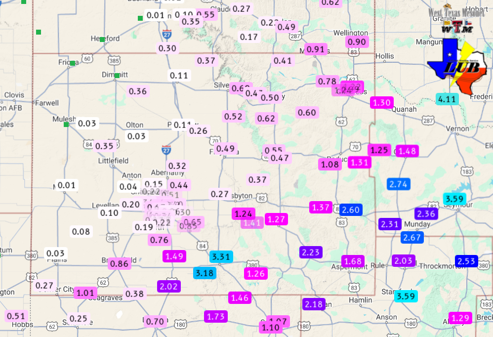
Rain totals of 1 to 3+ inches were common from the southeast South Plains through the southern Texas Panhandle, with the heaviest swath of rain affecting locations over central and southwestern Garza County, including Post, as well as southeastern King County. Runoff from the torrential rainfall led to a surge of water running down the Brazos River at Justiceburg, which lifted Lake Alan Henry about 1 foot, bringing it just under a foot below full conservation level. |
|
 |
|
| 24-hour radar-estimated and biased-corrected precipitation ending at 7 am on Wednesday (30 April 2025). Rainfall over this same period, measured by the West Texas Mesonet, can be VIEWED HERE. | |
| A list of the preliminary storm reports collected on April 29th can be found below. | |
Preliminary Local Storm Report
National Weather Service Lubbock TX
1037 AM CDT Wed Apr 30 2025

..TIME...   ...EVENT...      ...CITY LOCATION...     ...LAT.LON...
..DATE...   ....MAG....      ..COUNTY LOCATION..ST.. ...SOURCE....
            ..REMARKS..

0222 PM     Hail             6 E Tahoka              33.16N 101.69W
04/29/2025  M1.50 Inch       Lynn               TX   Trained Spotter

            Via Tahoka FD.

0233 PM     Hail             4 E Wolfforth           33.50N 101.95W
04/29/2025  E1.25 Inch       Lubbock            TX   Public

            Report from mPING: Half Dollar (1.25 in.).

0235 PM     Hail             1 W Wolfforth           33.51N 102.02W
04/29/2025  E1.00 Inch       Lubbock            TX   Public

            Report from mPING: Quarter (1.00 in.).

0241 PM     Hail             4 SE Reese Center       33.56N 101.97W
04/29/2025  E1.00 Inch       Lubbock            TX   Public

            Report from mPING: Quarter (1.00 in.).

0242 PM     Hail             11 E Tahoka             33.16N 101.60W
04/29/2025  M1.75 Inch       Lynn               TX   Fire Dept/Rescue

            Tahoka FD.

0242 PM     Hail             2 S Wolfforth           33.48N 102.01W
04/29/2025  E1.75 Inch       Lubbock            TX   Public

            Report from mPING: Golf Ball (1.75 in.).

0244 PM     Hail             6 SW Lubbock            33.54N 101.95W
04/29/2025  E1.00 Inch       Lubbock            TX   Public

            Report from mPING: Quarter (1.00 in.).

0246 PM     Hail             3 W Lubbock             33.57N 101.90W
04/29/2025  E1.00 Inch       Lubbock            TX   Public

            Report from mPING: Quarter (1.00 in.).

0251 PM     Hail             4 SE Reese Center       33.56N 101.97W
04/29/2025  E1.25 Inch       Lubbock            TX   Public

            Report from mPING: Half Dollar (1.25 in.).

0255 PM     Hail             2 SW Lubbock            33.57N 101.87W
04/29/2025  E1.25 Inch       Lubbock            TX   Public

            Report from mPING: Half Dollar (1.25 in.).

0256 PM     Hail             2 W Lubbock             33.59N 101.89W
04/29/2025  E2.00 Inch       Lubbock            TX   Public

            Report from mPING: Hen Egg (2.00 in.).

0256 PM     Hail             2 W Lubbock             33.59N 101.89W
04/29/2025  E2.00 Inch       Lubbock            TX   Public

            Report from mPING: Hen Egg (2.00 in.).

0311 PM     Hail             9 W Post                33.19N 101.54W
04/29/2025  M2.00 Inch       Garza              TX   Fire Dept/Rescue

            Tahoka FD.

0326 PM     Hail             2 NW Post               33.21N 101.40W
04/29/2025  E3.50 Inch       Garza              TX   Broadcast Media

            Media relayed public report. Time estimated
            from radar.

0328 PM     Hail             Post                    33.19N 101.38W
04/29/2025  M2.50 Inch       Garza              TX   Law Enforcement

            Garza County SO.

0345 PM     Flood            Post                    33.19N 101.38W
04/29/2025                   Garza              TX   Trained Spotter

            Numerous streets reported covered with water
            in Post.

0435 PM     Hail             9 SSE Guthrie           33.51N 100.26W
04/29/2025  M2.00 Inch       King               TX   Other Federal

            NSSL report.

0447 PM     Hail             15 S Guthrie            33.42N 100.26W
04/29/2025  E1.75 Inch       King               TX   Public

            Report from mPING: Golf Ball (1.75 in.).

0450 PM     Tstm Wnd Dmg     Jayton                  33.25N 100.57W
04/29/2025                   Kent               TX   CO-OP Observer

            Roof blown off a vacant home. Time estimated
            from radar.

0451 PM     Hail             Girard                  33.36N 100.66W
04/29/2025  M4.00 Inch       Kent               TX   Law Enforcement

            Kent County SO.

0454 PM     Hail             12 SSE Guthrie          33.47N 100.24W
04/29/2025  M5.00 Inch       King               TX   Storm Chaser

            Corrects previous hail report from 12 SSE
            Guthrie. Social media report.

0505 PM     Hail             14 ESE Guthrie          33.55N 100.10W
04/29/2025  M4.50 Inch       King               TX   Public

            Public report from mPING. Corrected for
            location. Location estimated from radar.

0525 PM     Hail             Floydada                33.98N 101.34W
04/29/2025  M1.75 Inch       Floyd              TX   CO-OP Observer

            Half dollar to golf ball size hail around
            town. Time estimated from radar.

0525 PM     Hail             Floydada                33.98N 101.34W
04/29/2025  M2.00 Inch       Floyd              TX   Public

            Media relayed public report.

0525 PM     Hail             Floydada                33.98N 101.34W
04/29/2025  M1.75 Inch       Floyd              TX   Fire Dept/Rescue

            Floydada FD.

0552 PM     Hail             8 NW Aspermont          33.21N 100.34W
04/29/2025  E1.50 Inch       Stonewall          TX   Public

            Report from mPING: Ping Pong Ball (1.50
            in.).

0554 PM     Flash Flood      1 NW Jayton             33.26N 100.58W
04/29/2025                   Kent               TX   Public


0700 AM     Rain             1 NE Post               33.20N 101.37W
04/30/2025  M3.35 Inch       Garza              TX   CO-OP Observer

            24-hour rain total measured this morning.
            The rain fell between 3 pm yesterday and 7
            am this morning.

