|
| Storm Reports |
| Are you interested in what happened during a recent event? Check out the report below. |
|
|
 |
Very Warm/Dry Then Turning Cooler on February 25-28, 2024 |
 |
| |
|
|
| |
|
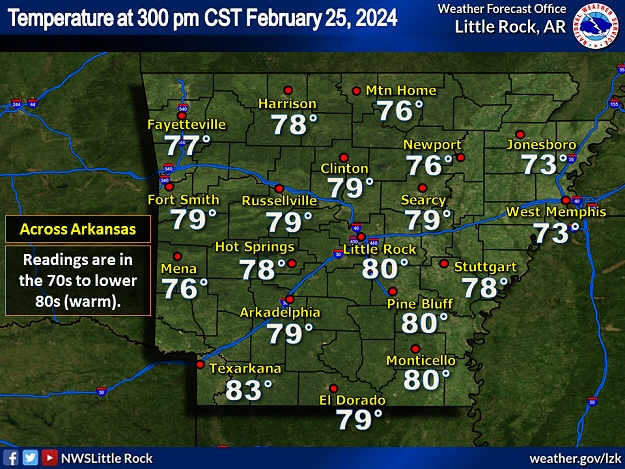
Arkansas was on track to have one of the warmest Februarys on record, and the 25th just added to the fire. Afternoon temperatures were in the 70s to lower 80s, which was well above normal readings in the mid 50s to lower 60s. The high at Little Rock (Pulaski County) was 81 degrees, making this the earliest 80 degree day since 2018. A day later, the mercury hit 90 degrees at Texarkana (Miller County). It had never been so warm so early locally.
Not only did it feel like spring, moisture was lacking. On the 25th, for example, afternoon humidity levels were largely below 30 percent.
|
| Average Temperatures in February, 2024 (Through the 28th) |
| Site |
Average Temperature |
Departure |
| Fayetteville (NW AR) |
49.3° |
+9.0° |
| Harrison (NC AR) |
50.2° |
+9.3° |
| Jonesboro (NE AR) |
50.8° |
+8.1° |
| Fort Smith (WC AR) |
53.4° |
+8.4° |
| Little Rock (C AR) |
55.2° |
+10.6° |
| West Memphis (EC AR) |
50.3° |
+5.2° |
| Texarkana (SW AR) |
58.4° |
+10.1° |
| El Dorado (SC AR) |
54.8° |
+6.3° |
| Pine Bluff (SE AR) |
54.9° |
+8.4° |
|
|
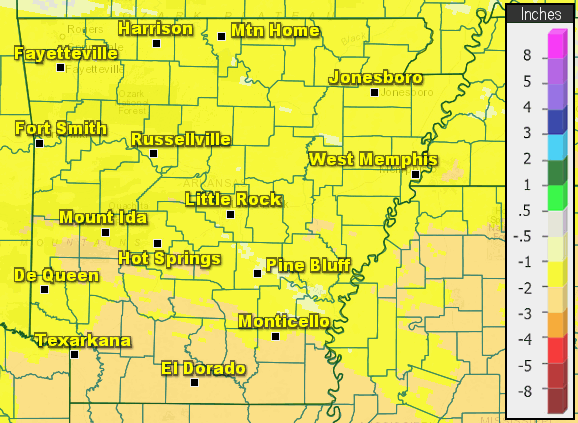
| In the picture: Precipitation was one to more than two inches below average in the two week period ending at 600 am CST on 02/28/2024. |
|
| |
|
A dry air mass contributed at a lack of rain during the latter half of February. During this time frame, precipitation was one to more than two inches subpar. This was after a somewhat wet start to the month (and a sopping wet January). The wildfire concern was ramping up.
|
|
|
| In the pictures: Strong and gusty southwest winds on 02/27/2024 shifted to the northwest the next day behind a cold front. Gusts were over 40 mph in places both days. |
|
| |
|
A cold front on the 27th did nothing to help the situation. In fact, matters got worse as wind speeds picked up surrounding the front. If there were any wildfires, gusts over 40 mph helped fan the flames
|
|
|
| In the video: A strong cold front arrived from the Plains on 02/27/2024. Preceding the front, afternoon temperatures were in the 70s/80s. The next day, readings in the afternoon were in the 40s/50s behind the front. |
|
| |
|
Following the front, afternoon temperatures on the 28th were more than thirty degrees cooler than the day before at many sites. However, the front provided another round of very dry air, and humidity levels plummeted.
|
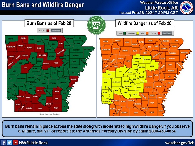 |
| In the picture: Burn bans were posted in twenty counties and there was a moderate to high wildfire danger across Arkansas on 02/28/2024. The information is courtesy of the Arkansas Forestry Commission. |
|
| |
|
It is no wonder that almost thirty counties had burn bans posted on the 28th, and a moderate to high wildfire danger existed.
|
| Freeze Worries |
|
Vegetation started making an early comeback in February given well above average temperatures. Since freezes typically occur as late as mid-March to mid-April in Arkansas, budding and flowering plants will be vulnerable to any blasts of cold air that arrive in the coming weeks.
|
|
|