 |
| For Your Information |
| If there is something that may be of interest to you, we will try to make that information available. |
|
|
 |
What is a Tornado Emergency? |
 |
| |
| Back in 1999, a destructive tornado (eventually rated F5) was bearing down on the Oklahoma City, OK area on May 3rd. Forecasters at the National Weather Service in Norman, OK had a Tornado Warning in effect, but felt that it was not enough. They needed to enhance the wording in the warning somehow to catch the attention of people in the path of this monster. That is when the Tornado Emergency was hatched. |
...TORNADO EMERGENCY IN SOUTH OKLAHOMA CITY METRO AREA...

AT 6:57 PM CDT...A LARGE TORNADO WAS MOVING ALONG INTERSTATE 44 WEST
OF NEWCASTLE. ON ITS PRESENT PATH...THIS LARGE DAMAGING TORNADO WILL
ENTER SOUTHWEST SECTIONS OF THE OKLAHOMA CITY METRO AREA BETWEEN
7:15 AND 7:30 PM. PERSONS IN MOORE AND SOUTH OKLAHOMA CITY SHOULD
TAKE IMMEDIATE TORNADO PRECAUTIONS!

THIS IS AN EXTREMELY DANGEROUS AND LIFE THREATENING SITUATION. IF
YOU ARE IN THE PATH OF THIS LARGE AND DESTRUCTIVE TORNADO...TAKE
COVER IMMEDIATELY.

DOPPLER RADAR HAS INDICATED THIS STORM MAY CONTAIN DESTRUCTIVE HAIL
TO THE SIZE OF BASEBALLS...OR LARGER.
|
 |
| Rotation | Debris Ball | More About Rotation |
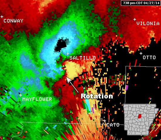
| In the pictures: The WSR-88D (Doppler Weather Radar) showed strong rotation between Mayflower and Vilonia (both in Faulkner County) at 738 pm CDT on 04/27/2014. There was also a debris ball present, which is a very good indicator of a tornado causing damage. |
|
| |
|
There was no guidance on how to write such a product. Forecasters did not follow any protocol. They just did it.
In 2007, the National Weather Service in Dodge City, KS was faced with a similar situation on May 4th. Tornado Emergencies were still unofficial and hardly ever used, but that did not stop one from going out to the people of Greensburg, KS (preceding an EF5 monster).
Fast forward to the Super Tuesday Tornado Outbreak of February 5, 2008, and a record (for that time) five Tornado Emergencies were disseminated in Tennessee and Alabama. There were none in Arkansas.
|
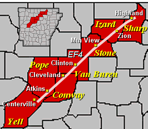 |
That was the day a deadly tornado (rated EF4) cut a 122 mile swath through seven counties in northern sections of the state and killed 13 people. Tornado Warnings were issued for this storm, but no Tornado Emergencies. Why on earth not? |
| In the picture: A tornado rated EF4 tracked through portions of Yell, Pope, Conway, Van Buren, Stone, Izard and Sharp Counties on 02/05/2008. |
|
As pointed out in a service assessment following the event, "Little Rock personnel felt that the Tornado Emergency was to be reserved for tornadoes impinging on densely populated areas. This is the general perception of all WFOs (Weather Forecast Offices). During this event, there was no national guidance on when to use Tornado Emergency wording."
Not long after, the Tornado Emergency was formalized and officially recognized. Today, National Weather Service directives specify that Tornado Emergencies are reserved for rare situations when:
|
| a. |
Severe threat to human life is imminent or ongoing. |
| b. |
Catastrophic damage is imminent or ongoing. |
| c |
Reliable sources confirm tornado (either 1 or 2): |
| |
1. Visual. |
| |
2. Radar imagery strongly suggests the existence of a damaging tornado (a debris ball signature, for example). |
|
|
|

