NOAA NWS Marine Weather Services
National Program
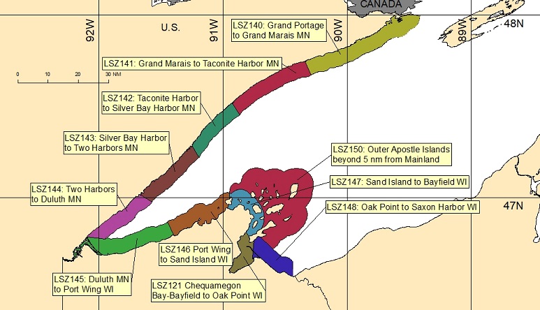
| Minnesota Shore Line | Wisconsin Shore Line |
| LSZ140: Grand Portage to Grand Marais, MN | LSZ145: Duluth, MN to Port Wing, WI |
| LSZ141: Grand Marais to Taconite Harbor, MN | LSZ146: Port Wing to Sand Island, WI |
| LSZ142: Taconite Harbor to Silver Bay Harbor, MN | LSZ147: Sand Island to Bayfield, WI |
| LSZ143: Silver Bay Harbor to Two Harbors, MN | LSZ148: Oak Point Saxon Harbor WI |
| LSZ144: Two Harbors to Duluth, MN | LSZ150: Outer Apostle Islands beyond 5 NM from Mainland |
| LSZ121: Chequamegon Bay-Bayfield to Oak Point WI |
Great Lakes Marine Weather Portal - Includes point forecasts
Nearshore Marine Forecast which includes all these zones
Special Marine Warning(s) and Marine Weather Statement(s) for these zones
Marine Weather Message for these zones
Open Lake Forecast for Lake Superior (All Zones- Includes Synopsis and MAFOR) (individual zones)
Experimental Modernized Open Lake Forecast for Lake Superior
Graphical Marine Forecasts are available here. Choose the map background and forecast element and zoom in to your area of interest.
Great Lakes nearshore forecasts are subdivided by zone, each identified by text description and a Universal Generic Code (UGC). The different colors used in the map above have no meaning and are only intended to assist in differentiating the zones.
Great Lakes nearshore marine forecasts are issued throughout the boating season, typically beginning around April 1 and ending around December 31, dependent on ice conditions on the entrances to each individual lake. During periods of climatological extremes leading to erratic ice coverage patterns (shifting of ice edge, late/early freeze, etc.), and based on customer needs, nearshore forecasts may be issued throughout the winter to support the National Weather Service mission of protecting life and property on the waters of the Great Lakes.
These forecasts are also available via e-mail
NOTICE - Check time and date of forecasts. Linked data may not represent the latest forecast.
NWS Internet is available 24 hours a day, seven days a week . Timely delivery of data and products through the Internet is not guaranteed. Official NWS dissemination systems which can provide timely delivery of data and products are listed in our DISCLAIMER.
US Dept of Commerce
National Oceanic and Atmospheric Administration
National Weather Service
NOAA NWS Marine Weather Services
1325 East-West Hwy, 13th floor
Communications Office
Silver Spring, MD 20910
Comments? Questions? Please Contact Us.

