
Wildfires and poor air quality continue for the Pacific Northwest, Rockies and extended into the Plains. Severe thunderstorms possible for the northern Plains and upper Midwest on Monday along a frontal boundary. Another boundary will focus showers and thunderstorms for the eastern seaboard with localized heavy rainfall possible. For Alaska, a strong Bering Sea storm will bring winds and rainfall. Read More >
National Weather Service Omaha/Valley,NE
Home | Office | Staff |
The Omaha Weather Forecast Office (WFO) has a long and storied history. Weather observations in the Omaha area began during the Lewis and Clark expedition in the early 1800s. In the late 1800s, upper-air data collection commenced using kites. Today, rawinsonde upper-air observations are conducted in western Douglas County at the present-day National Weather Service office.
++++++++++++++++++++++++++++++++++++++++++++++++++++++++++++++++++++++++++++++++++++++++++++++++++++
Current location
The Omaha/Valley, NE Weather Forecast Office (WFO) is situated roughly one mile northwest of Valley, Nebraska—about 23 miles west-northwest of downtown Omaha and approximately 32 miles northwest of Offutt Air Force Base. The office occupies a 10-acre site at the southeast corner of North 288th Street and Ida Street (Nebraska Highway 64).
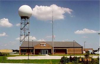
The present forecast office, upper air site, and WSR-88D radar has been at Valley since 1994.
++++++++++++++++++++++++++++++++++++++++++++++++++++++++++++++++++++++++++++++++++++++++++++++++++++
Previous site.
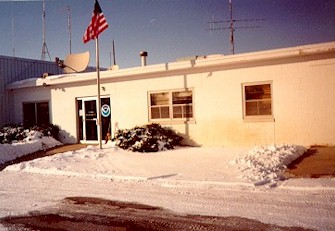
The upper air, radar, and forecast offices were co-located at the 72nd and McKinley site from 1974 to 1994.
++++++++++++++++++++++++++++++++++++++++++++++++++++++++++++++++++++++++++++++++++++++++++++++++++++
Dual Operations 1954 to 1974
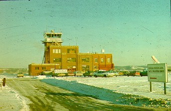
The second floor at Eppley Airport was the forecast office site from 1941 to 1974.
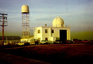
The upper air and radar (WSR-1) site was located at North Omaha Airport from 1954 to 1974.
++++++++++++++++++++++++++++++++++++++++++++++++++++++++++++++++++++++++++++++++++++++++++++++++++++
July 19, 2011, Installation and testing of the new AWIPS II forcast system began.
October 7, 2013, AWIPS II system was accepted as operational.
1804 - late July - Lewis and Clark expedition records weather observations near Omaha and Council Bluffs.
1820-1826 - First continuous temperature observations taken in Omaha area by U.S. Army Surgeons (Ft. Atkinson near Ft. Calhoun).
1870 - First U.S. Signal Corps Office in Omaha in Old Market Area.
1871 - First river gage installed to monitor the Missouri River at Omaha.
1891 - Weather Bureau established under Department of Agriculture.
1897-1898 - First kite flight with temperature recording equipment.
1898 - First national convention of U.S. Weather Bureau held in Omaha.
1909 - Exploratory free balloon flights at Fort Omaha.
1913 - Omaha Easter Sunday tornado on March 23. 156 people killed, 1700 homes destroyed or damaged.
1919 - Weather Bureau takes over pilot ballon program from the Signal Corps.
1931-1938 - Airplane flights used to obtain upper air data.
1938 - First radiosonde flight replaces airplane soundings.
1941 - City office and airport offices consolidated at Eppley Airfield.
1952 April 18 - All time record flood on Missouri flood at Omaha.
1954 September 16 - Upper air site established at North Omaha Airport.
1955 - The WSR-1 weather radar installed at North Omaha Airport.
1972 - Weather Service forecast office for Nebraska established at Eppley Airfield in Omaha.
1974 - North Omaha airport and Eppley Airfield offices consolidated at 72nd and McKinley (North Omaha).
1975 May 6 - Omaha Tornado. Three deaths, hundreds injured and $150 million in damage.
1977 - WSR-74C weather radar installed at North Omaha.
1994 - Weather Forecast Office moved to location northwest of Valley, Nebraska. WSR-88D doppler radar installed.
1996 June 12 - Wind gust of 92 mph is recorded at the Weather Service office.
2019 March 12-18 - Deadly flooding impacted a large portion of eastern Nebraska and western Iowa. WFO Omaha was temporarily evacuated due to flooding.


 Back to the home page.