
Dangerous heat will expand from the Gulf Coast into the Southern Plains and Desert Southwest through week's end. Additional extreme heat impacting the Pacific Northwest will shift to the northern Plains by the weekend. Tropical Storm Bertha is expected to continue to impact portions of the northern Gulf Coast from the western Florida Panhandle to southeastern Louisiana through tonight. Read More >
A tornado outbreak occurred over parts of northern and central Oklahoma during the day on May 24, 2011, with violent tornadoes devastating several communities. By the end of the day, one EF-5, two EF-4, and two EF-3 tornadoes destroyed buildings, ripped up trees and power poles, and unfortunately, resulted in 11 deaths and 293 injuries.
The day began with a strong upper level trough ejecting out of the southwestern United States. The trough took on a negative tilt as it approached the southern Plains. A strong jet stream was located at both the middle and upper levels rotating around the upper trough. At the surface, a low pressure strengthened rapidly over northwestern Oklahoma, keeping the low-level flow of warm, moist air to flow east of a dry line that had moved into western Oklahoma.
Thunderstorms developed by early afternoon over western Oklahoma, and quickly became supercells as they moved northeast. Strong low-level rotation developed early, with the first tornado occurring over Blaine County, and moved northeast into Major County. Another supercell rapidly gained low-level rotation as it moved from Caddo into Canadian County. This tornado became the strongest of them all as it moved north of El Reno, west of Piedmont, and to south of Guthrie in Logan county. Nine people died as a result of this violent tornado.
Two more powerful supercells developed over Grady county, and they moved northeast into McClain and Cleveland counties. Finally, the final tornado occurred east of Norman into Pottawatomie county. The timing of this outbreak could not have come at a worse time, as rush hour was just unfolding as the tornadoes neared the Oklahoma City metro area.
 |
 |
 |
| Radar reflectivity and storm relative velocity images for Central OK at 5:31 pm CDT on May 24, 2011 | Tornado near Chickasha - Photo courtesy of Derrick James | Tornado near Lookeba - Photo courtesy of Dal Archer |

| Year | Total |
| 2011 | 22 |
| 1998 | 16 |
| 1957 | 12 |
| 2008 | 10 |
| 1962 | 8 |
This GIS file contains tornado paths for the "Calumet-El Reno-Piedmont-Guthrie" tornado, the "Chickasha-Blanchard-Newcastle" tornado, the "Washington-Goldsby" tornado, and the "Stillwater" tornado.
PUBLIC INFORMATION STATEMENT...UPDATED
NATIONAL WEATHER SERVICE NORMAN OK
340 PM CDT WED JUN 8 2011
... MAY 24, 2011 OKLAHOMA TORNADO OUTBREAK ...
UPDATED PATHS TO TORNADOES 1.. 6.. 7 AND 8. ADDED TORNADOES 5 AND 9.
...EVENT OVERVIEW...
STRONG TO VIOLENT TORNADOES MOVED ACROSS PARTS OF WESTERN AND
CENTRAL OKLAHOMA DURING THE AFTERNOON AND EVENING HOURS OF
MAY 24TH. STORMS INITIALLY FORMED ACROSS SOUTHWEST OKLAHOMA AND
QUICKLY BECAME SEVERE AS THEY MOVED NORTHEAST. SEVERAL OF THESE
STORMS PRODUCED TORNADOES ALONG WITH VERY LARGE HAIL. ANOTHER
CONCENTRATED AREA OF SEVERE STORMS MOVED ACROSS SOUTH CENTRAL AND
SOUTHEAST OKLAHOMA BETWEEN 7 AND 10 PM.
STORM 1... CANTON LAKE
PRELIMINARY DATA...
EVENT DATE: MAY 24, 2011
EVENT TYPE: TORNADO
EF RATING: EF-3
ESTIMATED PEAK WINDS (MPH): UNKNOWN
INJURIES/FATALITIES: 2/0
EVENT START LOCATION AND TIME: 3 W CANTON 3:20 PM CDT
EVENT END LOCATION AND TIME: 6 WSW FAIRVIEW 3:43 PM CDT
DAMAGE PATH LENGTH (IN MILES): 13 MILES
WIDTH: 1/2 MILE
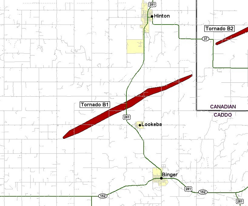
STORM 2... LOOKEBA
PRELIMINARY DATA...
EVENT DATE: MAY 24, 2011
EVENT TYPE: TORNADO
EF RATING: EF-3
ESTIMATED PEAK WINDS (MPH): 140
INJURIES/FATALITIES: UNKNOWN/0
EVENT START LOCATION AND TIME: 4 WSW LOOKEBA 3:31 PM CDT
EVENT END LOCATION AND TIME: 4 NE LOOKEBA 3:46 PM CDT
DAMAGE PATH LENGTH (IN MILES): 9 MILES
DAMAGE WIDTH: TO BE DETERMINED
NOTE: DETERMINED TO BE A SEPARATE TORNADO FROM CALUMET TORNADO
BASED ON ANALYSIS OF GROUND SURVEY AND MOBILE RADAR OBSERVATIONS.
STORM 3... FAIRVIEW
PRELIMINARY DATA...
EVENT DATE: MAY 24, 2011
EVENT TYPE: TORNADO
EF RATING: EF-0
ESTIMATED PEAK WINDS (MPH): UNKNOWN
INJURIES/FATALITIES: 0/0
EVENT LOCATION AND TIME: 2 SW FAIRVIEW 3:47 PM TO 3:51 PM CDT
DAMAGE PATH LENGTH (IN MILES): UNKNOWN
WIDTH: UNKNOWN
NOTE: THIS TORNADO PRODUCED NO KNOWN DAMAGE BUT WAS OBSERVED BY
SPOTTERS. THE LOCATION IS ESTIMATED.
STORM 4... CALUMET-EL RENO-PIEDMONT-GUTHRIE
PRELIMINARY DATA...
EVENT DATE: MAY 24, 2011
EVENT TYPE: TORNADO
EF RATING: EF-5
ESTIMATED PEAK WINDS (MPH): GREATER THAN 210 MPH
INJURIES/FATALITIES: UNKNOWN/9
EVENT START LOCATION AND TIME: 4 ESE HINTON 3:50 PM CDT
EVENT END LOCATION AND TIME: 4 NE GUTHRIE 5:35 PM CDT
DAMAGE PATH LENGTH (IN MILES): 65 MILES
DAMAGE WIDTH: TO BE DETERMINED
NOTE: RATING BASED ON UNIVERSITY OF OKLAHOMA MOBILE DOPPLER RADAR
MEASUREMENTS.
STORM 5... RICHLAND
PRELIMINARY DATA...
EVENT DATE: MAY 24, 2011
EVENT TYPE: TORNADO
EF RATING: EF-0
ESTIMATED PEAK WINDS (MPH): UNKNOWN
INJURIES/FATALITIES: NONE/NONE
EVENT LOCATION AND TIME: 3 NW RICHLAND 4:37 TO 4:38 PM CDT
DAMAGE PATH LENGTH (IN MILES): 1 MILE
DAMAGE WIDTH: UNKNOWN
STORM 6... CHICKASHA-BLANCHARD-NEWCASTLE
PRELIMINARY DATA...
EVENT DATE: MAY 24, 2011
EVENT TYPE: TORNADO
EF RATING: EF-4
ESTIMATED PEAK WINDS (MPH): 190
INJURIES/FATALITIES: UNKNOWN/1
EVENT START LOCATION AND TIME: 2 S CHICKASHA 5:06 PM CDT
EVENT END LOCATION AND TIME: SOUTHWEST OKLAHOMA CITY NEAR
SOUTHWEST 149TH AND PORTLAND AVENUE AT 6:01 PM CDT
DAMAGE PATH LENGTH (IN MILES): 32 MILES
DAMAGE WIDTH: UNKNOWN
STORM 7... WASHINGTON-GOLDSBY
PRELIMINARY DATA...
EVENT DATE: MAY 24, 2011
EVENT TYPE: TORNADO
EF RATING: EF-4
ESTIMATED PEAK WINDS (MPH): 190
INJURIES/FATALITIES: UNKNOWN/NONE
EVENT START LOCATION AND TIME: 2 W BRADLEY 5:26 PM CDT
EVENT END LOCATION AND TIME: 1 W GOLDSBY 6:05 PM CDT
DAMAGE PATH LENGTH (IN MILES): 23 MILES
DAMAGE WIDTH: UNKNOWN
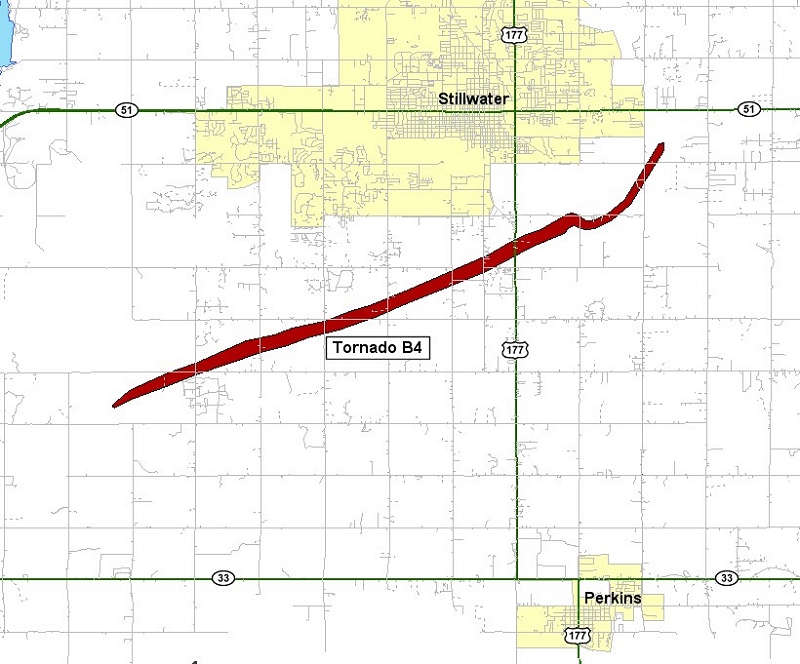
STORM 8... STILLWATER
PRELIMINARY DATA...
EVENT DATE: MAY 24, 2011
EVENT TYPE: TORNADO
EF RATING: EF-2
ESTIMATED PEAK WINDS (MPH): 130
INJURIES/FATALITIES: UNKNOWN/NONE
EVENT START LOCATION AND TIME: 8 SW STILLWATER 5:50 PM CDT
EVENT END LOCATION AND TIME: 3 ESE STILLWATER 6:05 PM CDT
DAMAGE PATH LENGTH (IN MILES): 10 MILES
DAMAGE WIDTH: 880 YARDS
STORM 9... GOLDSBY
PRELIMINARY DATA...
EVENT DATE: MAY 24, 2011
EVENT TYPE: TORNADO
EF RATING: EF-1
ESTIMATED PEAK WINDS (MPH): TO BE DETERMINED
INJURIES/FATALITIES: NONE/NONE
EVENT LOCATION AND TIME: 2.5 SE GOLDSBY AT 6:02 PM CDT
DAMAGE PATH LENGTH (IN MILES): 0.5 MILES
DAMAGE WIDTH: UNKNOWN
STORM 10... MCLOUD
PRELIMINARY DATA...
EVENT DATE: MAY 24, 2011
EVENT TYPE: TORNADO
EF RATING: EF-1
ESTIMATED PEAK WINDS (MPH): 110
INJURIES/FATALITIES: 1/NONE
EVENT START LOCATION AND TIME: 4.5 SSW MCLOUD 6:36 PM CDT
EVENT END LOCATION AND TIME: 3.5 S MCLOUD 6:39 PM CDT
DAMAGE PATH LENGTH (IN MILES): 2 MILES
WIDTH: 50 YARDS.
STORM 11... RAVIA
PRELIMINARY DATA...
EVENT DATE: MAY 24, 2011
EVENT TYPE: TORNADO
EF RATING: EF-1
ESTIMATED PEAK WINDS (MPH): 95
INJURIES/FATALITIES: NONE/NONE
EVENT START LOCATION AND TIME: 1 NW RAVIA 7:30 PM CDT
EVENT END LOCATION AND TIME: 2 N TISHOMINGO 7:45 PM CDT
DAMAGE PATH LENGTH (IN MILES): 6 MILES
WIDTH: UNKNOWN
$$
|
| A1 | A2 | B1 | B2 | B3 | B4 | C1 | C2 | D1 | D2 | D3 | E1 |
| Tornadoes by Intensity | ||||||
|---|---|---|---|---|---|---|
| EF0 | EF1 | EF2 | EF3 | EF4 | EF5 | Total |
| 3 | 2 | 2 | 2 | 2 | 1 | 12 |
| Tornado Number |
Event Tornado ID |
Storm Name | Time (CDT) |
Length of Path (miles) |
Width of Path (yards) |
EF- Scale |
Killed | Injured | County | Location |
|---|---|---|---|---|---|---|---|---|---|---|
| 1 | A1 | Canton Lake | 1520-1543 | 13 | 880 | EF3 | 1 | 2 | Dewey/ Blaine/ Major | 3 W Canton - 6 WSW Fairview |
| 2 | B1 | Lookeba | 1531-1546 | 9 | 800 | EF3 | 0 | 0 | Caddo | 4 WSW Lookeba - 4 NE Lookeba |
| 3 | A2 | Fairview | 1547-1551 | 0.7 | 80 | EF0 | 0 | 0 | Major | 2 SW Fairview |
| 4 | B2 | Calumet-El Reno-Piedmont-Guthrie | 1550-1735 | 63 | 1760 | EF5 | 9 | 181 | Canadian/ Kingfisher/ Logan | 4 ESE Hinton - 4 NE Guthrie |
| 5 | B3 | Richland | 1637-1638 | 1.5 | 50 | EF0 | 0 | 0 | Canadian | 3 NW Richland |
| 6 | C1 | Chickasha-Blanchard-Newcastle | 1706-1801 | 33 | 880 | EF4 | 1 | 48 | Grady/ McClain/ Cleveland | 2 S Chickasha - SW Oklahoma City (near SW 149th and Portland) |
| 7 | D1 | Washington- Goldsby |
1726-1805 | 23 | 880 | EF4 | 0 | 61 | Grady/ McClain | 2 W Bradley - 1 W Goldsby |
| 8 | C2 | Newcastle | 1745-1746 | 0.7 | 50 | EF0 | 0 | 0 | McClain | 2 SW Newcastle |
| 9 | B4 | Stillwater | 1750-1805 | 10 | 880 | EF2 | 0 | 0 | Payne | 8 SW - 3 ESE Stillwater |
| 10 | D2 | Goldsby | 1802 | 0.5 | 40 | EF1 | 0 | 0 | McClain | 2.5 SE Goldsby |
| 11 | D3 | McLoud | 1836-1839 | 2 | 50 | EF2 | 0 | 1 | Pottawatmomie | 4.5 SSW McLoud - 3.5 S McLoud |
| 12 | E1 | Ravia | 1930-1945 | 5 | 1200 | EF1 | 0 | 0 | Johnston | 1 NNW Ravia - 3 NNE Tishomingo |
| Tornado Number |
Date | Time (CST) |
Length of Path (miles) |
Width of Path (yards) |
F-Scale | Killed | Injured | County | Location |
|---|---|---|---|---|---|---|---|---|---|
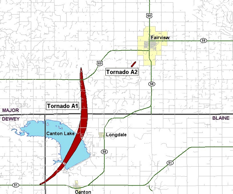
| A1 | 05/24/2011 | 1420-1444 | 13 | 880 | EF3 | 1 | 2 | Dewey/ Blaine/ Major | 3 W Canton - Canton Lake - 6 WSW Fairview |
This large tornado began west of Canton in Dewey County and moved north-northeast toward (and eventually over) Canton Lake. The damage was confined to trees and power poles/lines during the early stages of the tornado. However, more significant damage occurred as the tornado moved into Blaine County.
The tornado moved northeast toward Canton Lake, which is where more significant damage occurred. Near the lake, on both sides where the tornado crossed, significant tree damage occurred. Numerous trailer homes were knocked over or destroyed. On the south side of the lake, two injuries occurred at the Canadian Campground. Several other campers took shelter in a concrete bathhouse. Although the bathhouse sustained damage, no injuries were reported. Other concrete structures (benches, pick-nick tables, etc.) were knocked over or shattered. On the other side of the lake, southwest of Longdale, significant damage continued to more structures and trees.
The tornado then continued to move almost due north into Major County and hit homesteads and barns, severely damaging most structures, and splintering trees and power poles. One of the farmsteads received on the upper end of EF-3 damage, with the house completely collapsing and the trees on the property debarked and snapped. The tornado continued near Cedar Springs, damaging the church roof, and severely damaging a mobile home and several buildings at a farmstead. The tornado finally lifted southwest of Fairview.
| Twin Lakes, OK (KTLX) Radar Relectivity and Storm Relative Velocity | |
|---|---|
 Combination Radar Reflectivity and Storm Relative Velocity at 3:02 PM CDT on 5/24/2011") 3:02 PM CDT |
 Combination Radar Reflectivity and Storm Relative Velocity at 3:06 PM CDT on 5/24/2011") 3:06 PM CDT |
 Combination Radar Reflectivity and Storm Relative Velocity at 3:10 PM CDT on 5/24/2011") 3:10 PM CDT |
 Combination Radar Reflectivity and Storm Relative Velocity at 3:14 PM CDT on 5/24/2011") 3:14 PM CDT |
 Combination Radar Reflectivity and Storm Relative Velocity at 3:19 PM CDT on 5/24/2011") 3:19 PM CDT |
 Combination Radar Reflectivity and Storm Relative Velocity at 3:23 PM CDT on 5/24/2011") 3:23 PM CDT |
 Combination Radar Reflectivity and Storm Relative Velocity at 3:27 PM CDT on 5/24/2011") 3:27 PM CDT |
 Combination Radar Reflectivity and Storm Relative Velocity at 3:32 PM CDT on 5/24/2011") 3:32 PM CDT |
 Combination Radar Reflectivity and Storm Relative Velocity at 3:36 PM CDT on 5/24/2011") 3:36 PM CDT |
 Combination Radar Reflectivity and Storm Relative Velocity at 3:40 PM CDT on 5/24/2011") 3:40 PM CDT |
 Combination Radar Reflectivity and Storm Relative Velocity at 3:45 PM CDT on 5/24/2011") 3:45 PM CDT |
 Combination Radar Reflectivity and Storm Relative Velocity at 3:49 PM CDT on 5/24/2011") 3:49 PM CDT |
 Combination Radar Reflectivity and Storm Relative Velocity at 3:53 PM CDT on 5/24/2011") 3:53 PM CDT |
|
| Vance AFB, OK (KVNX) Radar Relectivity and Storm Relative Velocity | |
 Combination Radar Reflectivity and Storm Relative Velocity at 3:10 PM CDT on 5/24/2011") 3:10 PM CDT |
 Combination Radar Reflectivity and Storm Relative Velocity at 3:15 PM CDT on 5/24/2011") 3:15 PM CDT |
 Combination Radar Reflectivity and Storm Relative Velocity at 3:20 PM CDT on 5/24/2011") 3:20 PM CDT |
 Combination Radar Reflectivity and Storm Relative Velocity at 3:24 PM CDT on 5/24/2011") 3:24 PM CDT |
 Combination Radar Reflectivity and Storm Relative Velocity at 3:29 PM CDT on 5/24/2011") 3:29 PM CDT |
 Combination Radar Reflectivity and Storm Relative Velocity at 3:34 PM CDT on 5/24/2011") 3:34 PM CDT |
 Combination Radar Reflectivity and Storm Relative Velocity at 3:38 PM CDT on 5/24/2011") 3:38 PM CDT |
 Combination Radar Reflectivity and Storm Relative Velocity at 3:43 PM CDT on 5/24/2011") 3:43 PM CDT |
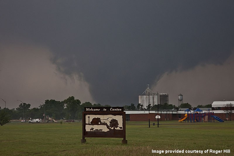 Photo provided courtesy of Roger Hill |
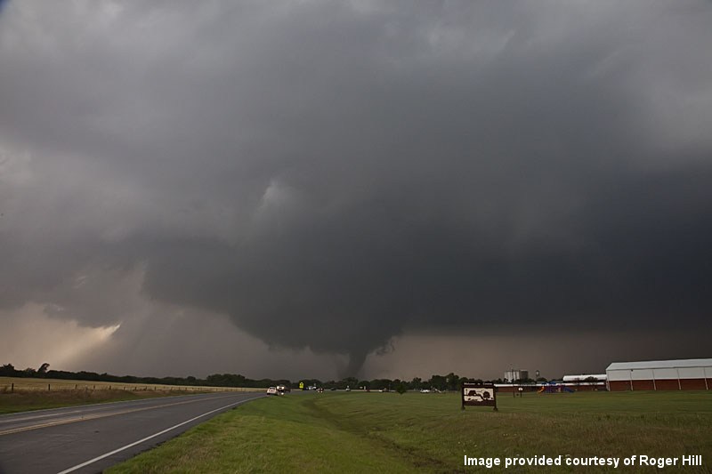 Photo provided courtesy of Roger Hill |
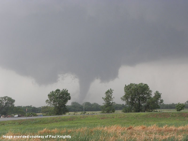 Photo provided courtesy of Paul Knightly |
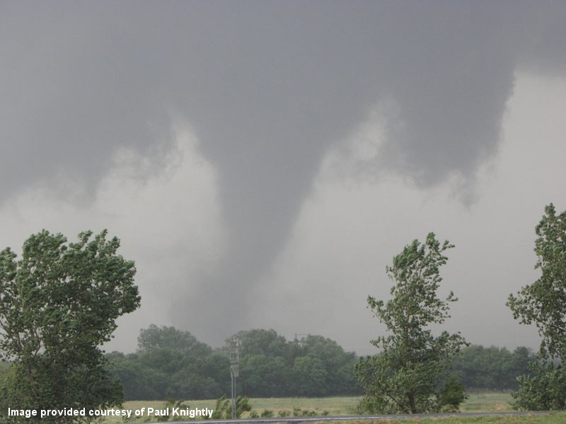 Photo provided courtesy of Paul Knightly |
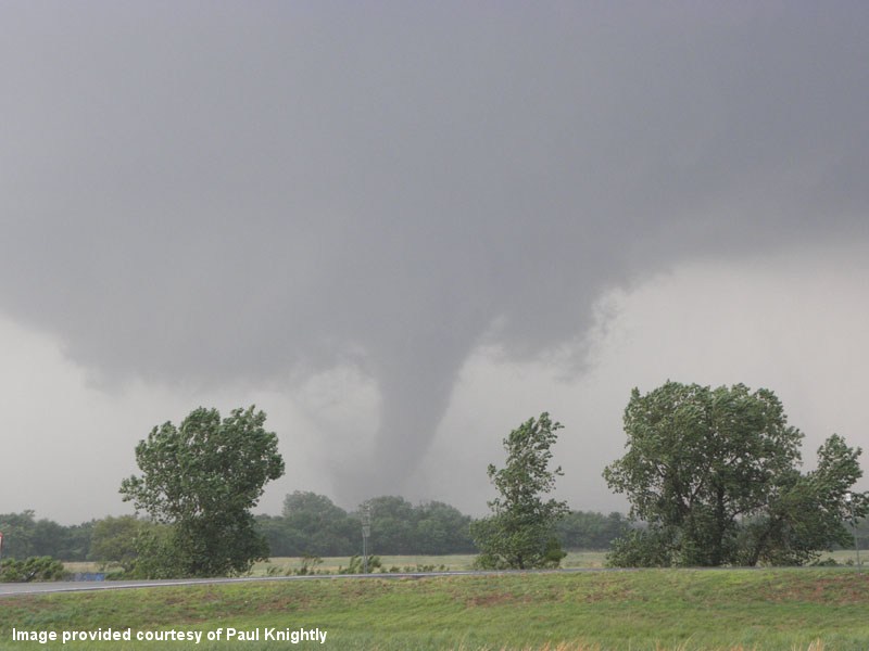 Photo provided courtesy of Paul Knightly |
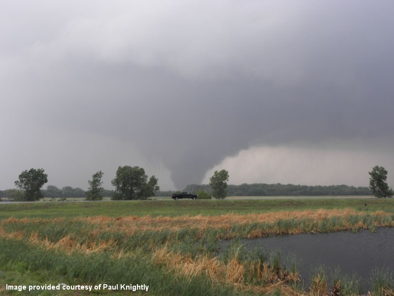 Photo provided courtesy of Paul Knightly |
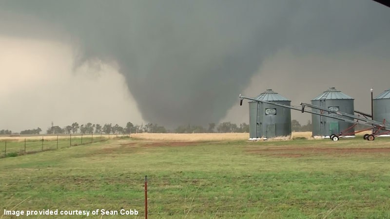 Photo provided courtesy of Sean Cobb |
Click on a time to jump to the product:
3:00 PM CDT - 3:11 PM CDT - 3:28 PM CDT - 3:40 PM CDT - 3:52 PM CDT - 4:08 PM CDT - 4:22 PM CDT
WFUS54 KOUN 242000
TOROUN
OKC011-043-093-151-242045-
/O.NEW.KOUN.TO.W.0038.110524T2000Z-110524T2045Z/

BULLETIN - EAS ACTIVATION REQUESTED
TORNADO WARNING
NATIONAL WEATHER SERVICE NORMAN OK
300 PM CDT TUE MAY 24 2011

THE NATIONAL WEATHER SERVICE IN NORMAN HAS ISSUED A

* TORNADO WARNING FOR...
  NORTHERN BLAINE COUNTY IN NORTHWEST OKLAHOMA...
  NORTHEASTERN DEWEY COUNTY IN NORTHWEST OKLAHOMA...
  MAJOR COUNTY IN NORTHWEST OKLAHOMA...
  EXTREME SOUTHEASTERN WOODS COUNTY IN NORTHWEST OKLAHOMA...

* UNTIL 345 PM CDT

* AT 300 PM CDT...NATIONAL WEATHER SERVICE RADAR INDICATED A SEVERE
  THUNDERSTORM CAPABLE OF PRODUCING A TORNADO 10 MILES WEST OF
  CANTON...MOVING NORTHEAST AT 45 MPH.

* LOCATIONS IN THE WARNING INCLUDE AMES...CANTON LAKE...CANTON...CLEO
  SPRINGS...FAIRVIEW...HOMESTEAD...HUCMAC...ISABELLA...LONGDALE...
  MENO...ORIENTA...ORION AND RINGWOOD.

PRECAUTIONARY/PREPAREDNESS ACTIONS...

TAKE COVER NOW. LEAVE MOBILE HOMES AND VEHICLES. IF POSSIBLE...MOVE
TO A BASEMENT OR STORM SHELTER. OTHERWISE MOVE TO AN INTERIOR ROOM OR
HALLWAY ON THE LOWEST FLOOR. STAY AWAY FROM WINDOWS AND OUTSIDE
WALLS.

&&

LAT...LON 3646 9855 3646 9811 3621 9812 3592 9880
      3610 9891
TIME...MOT...LOC 2000Z 221DEG 38KT 3606 9873

$$
WWUS54 KOUN 242011
SVSOUN
SEVERE WEATHER STATEMENT
NATIONAL WEATHER SERVICE NORMAN OK
311 PM CDT TUE MAY 24 2011
OKC151-242020-
/O.CAN.KOUN.TO.W.0038.000000T0000Z-110524T2045Z/
WOODS OK-
311 PM CDT TUE MAY 24 2011
...THE TORNADO WARNING HAS BEEN CANCELLED FOR EXTREME SOUTHEASTERN
WOODS COUNTY...
LAT...LON 3593 9877 3611 9879 3645 9848 3646 9811
3621 9812
TIME...MOT...LOC 2010Z 232DEG 36KT 3605 9867
$$
OKC011-043-093-242045-
/O.CON.KOUN.TO.W.0038.000000T0000Z-110524T2045Z/
DEWEY OK-BLAINE OK-MAJOR OK-
311 PM CDT TUE MAY 24 2011
...A TORNADO WARNING REMAINS IN EFFECT UNTIL 345 PM CDT FOR EASTERN
MAJOR...NORTHERN BLAINE AND NORTHEASTERN DEWEY COUNTIES...
AT 310 PM CDT...NATIONAL WEATHER SERVICE RADAR DETECTED A SEVERE
THUNDERSTORM CAPABLE OF PRODUCING A TORNADO 7 MILES WEST OF CANTON...
MOVING NORTHEAST AT 40 MPH. THE MOST DANGEROUS PORTION OF THE STORM
WILL BE APPROACHING THE CANTON AND LONGDALE AREAS. TAKE COVER
IMMEDIATELY!
* LOCATIONS IN THE WARNING INCLUDE AMES...CANTON LAKE...CANTON...CLEO
SPRINGS...FAIRVIEW...HOMESTEAD...ISABELLA...LONGDALE...MENO...
ORIENTA AND RINGWOOD.
LAT...LON 3593 9877 3611 9879 3645 9848 3646 9811
3621 9812
TIME...MOT...LOC 2010Z 232DEG 36KT 3605 9867
$$
WWUS54 KOUN 242028 RRA
SVSOUN
SEVERE WEATHER STATEMENT
NATIONAL WEATHER SERVICE NORMAN OK
328 PM CDT TUE MAY 24 2011
OKC011-043-093-242045-
/O.CON.KOUN.TO.W.0038.000000T0000Z-110524T2045Z/
DEWEY OK-BLAINE OK-MAJOR OK-
328 PM CDT TUE MAY 24 2011
...A TORNADO WARNING REMAINS IN EFFECT UNTIL 345 PM CDT FOR EASTERN
MAJOR...NORTHWESTERN BLAINE AND NORTHEASTERN DEWEY COUNTIES...
AT 328 PM CDT...RADAR AND STORM SPOTTERS OBSERVED A TORNADO NEAR
EASTERN CANTON LAKE...MOVING NORTHEAST AT 35 MPH. THIS TORNADO IS
MOVING TOWARD THE LONGDALE AREA. TAKE COVER IMMEDIATELY IF YOU LIVE
IN OR NEAR LONGDALE.
* LOCATIONS IN THE WARNING INCLUDE AMES...CANTON LAKE...CLEO
SPRINGS...FAIRVIEW...HOMESTEAD...ISABELLA...LONGDALE...MENO...
ORIENTA AND RINGWOOD.
LAT...LON 3609 9844 3606 9864 3618 9870 3645 9848
3646 9811 3621 9812
TIME...MOT...LOC 2028Z 213DEG 30KT 3613 9857
$$
WFUS54 KOUN 242040
TOROUN
OKC003-093-242145-
/O.NEW.KOUN.TO.W.0041.110524T2040Z-110524T2145Z/

BULLETIN - EAS ACTIVATION REQUESTED
TORNADO WARNING
NATIONAL WEATHER SERVICE NORMAN OK
340 PM CDT TUE MAY 24 2011

THE NATIONAL WEATHER SERVICE IN NORMAN HAS ISSUED A

* TORNADO WARNING FOR...
  SOUTHERN ALFALFA COUNTY IN NORTHWEST OKLAHOMA...
  EASTERN MAJOR COUNTY IN NORTHWEST OKLAHOMA...

* UNTIL 445 PM CDT

* AT 340 PM CDT...A THUNDERSTORM WITH A HISTORY OF PRODUCING
  TORNADOES WAS LOCATED 8 MILES SOUTHWEST OF FAIRVIEW...MOVING
  NORTHEAST AT 25 MPH.

* LOCATIONS IN THE WARNING INCLUDE ALINE...CARMEN...CLEO SPRINGS...
  FAIRVIEW...GOLTRY...HELENA AND ORIENTA.

PRECAUTIONARY/PREPAREDNESS ACTIONS...

TAKE COVER NOW. LEAVE MOBILE HOMES AND VEHICLES. IF POSSIBLE...MOVE
TO A BASEMENT OR STORM SHELTER. OTHERWISE MOVE TO AN INTERIOR ROOM OR
HALLWAY ON THE LOWEST FLOOR. STAY AWAY FROM WINDOWS AND OUTSIDE
WALLS.

&&

LAT...LON 3656 9810 3617 9843 3617 9864 3659 9846
TIME...MOT...LOC 2040Z 207DEG 23KT 3619 9856

$$
WWUS54 KOUN 242052
SVSOUN
SEVERE WEATHER STATEMENT
NATIONAL WEATHER SERVICE NORMAN OK
352 PM CDT TUE MAY 24 2011
OKC003-093-242145-
/O.CON.KOUN.TO.W.0041.000000T0000Z-110524T2145Z/
ALFALFA OK-MAJOR OK-
352 PM CDT TUE MAY 24 2011
...A TORNADO WARNING REMAINS IN EFFECT UNTIL 445 PM CDT FOR CENTRAL
MAJOR AND SOUTHERN ALFALFA COUNTIES...
AT 352 PM CDT...A THUNDERSTORM WITH A HISTORY OF PRODUCING TORNADOES
WAS LOCATED NEAR FAIRVIEW...MOVING NORTHEAST AT 40 MPH. THE
DANGEROUS PORTION OF THIS STORM IS HEADED TOWARD ORIENTA AND CLEO
SPRINGS. TAKE COVER NOW!
* LOCATIONS IN THE WARNING INCLUDE ALINE...CARMEN...CLEO SPRINGS...
FAIRVIEW...GOLTRY...HELENA AND ORIENTA.
LAT...LON 3624 9837 3625 9859 3659 9846 3656 9810
TIME...MOT...LOC 2052Z 209DEG 35KT 3632 9847
$$
WWUS54 KOUN 242108
SVSOUN
SEVERE WEATHER STATEMENT
NATIONAL WEATHER SERVICE NORMAN OK
408 PM CDT TUE MAY 24 2011
OKC003-093-242145-
/O.CON.KOUN.TO.W.0041.000000T0000Z-110524T2145Z/
ALFALFA OK-MAJOR OK-
408 PM CDT TUE MAY 24 2011
...A TORNADO WARNING REMAINS IN EFFECT UNTIL 445 PM CDT FOR NORTHERN
MAJOR AND SOUTHERN ALFALFA COUNTIES...
AT 408 PM CDT...A THUNDERSTORM WITH A HISTORY OF PRODUCING TORNADOES
WAS LOCATED NEAR ORIENTA...MOVING NORTHEAST AT 35 MPH.
* LOCATIONS IN THE WARNING INCLUDE ALINE...CARMEN...CLEO SPRINGS...
GOLTRY...HELENA AND ORIENTA.
LAT...LON 3632 9838 3636 9853 3659 9846 3656 9810
TIME...MOT...LOC 2108Z 207DEG 29KT 3642 9842
$$
WWUS54 KOUN 242122
SVSOUN
SEVERE WEATHER STATEMENT
NATIONAL WEATHER SERVICE NORMAN OK
422 PM CDT TUE MAY 24 2011
OKC003-093-242132-
/O.CAN.KOUN.TO.W.0041.000000T0000Z-110524T2145Z/
ALFALFA OK-MAJOR OK-
422 PM CDT TUE MAY 24 2011
...THE TORNADO WARNING HAS BEEN CANCELLED FOR NORTHERN MAJOR AND
SOUTHERN ALFALFA COUNTIES...
THE STORM HAS WEAKENED... BUT SMALL HAIL AND GUSTY WINDS MAY STILL
OCCUR.
LAT...LON 3632 9838 3636 9853 3659 9846 3656 9810
TIME...MOT...LOC 2122Z 207DEG 29KT 3652 9836
$$
| Tornado Number |
Date | Time (CST) |
Length of Path (miles) |
Width of Path (yards) |
F-Scale | Killed | Injured | County | Location |
|---|---|---|---|---|---|---|---|---|---|
| A2 | 05/24/2011 | 1447-1451 | 0.7 | 80 | EF0 | 0 | 0 | Major | 2 SW Fairview |
A number of storm chasers observed this tornado to the southwest of Fairview. No known damage occurred.
| Vance AFB, OK (KVNX) Radar Relectivity and Storm Relative Velocity | |
|---|---|
 Combination Radar Reflectivity and Storm Relative Velocity at 3:48 PM CDT on 5/24/2011") 3:48 PM CDT |
 Combination Radar Reflectivity and Storm Relative Velocity at 3:53 PM CDT on 5/24/2011") 3:53 PM CDT |
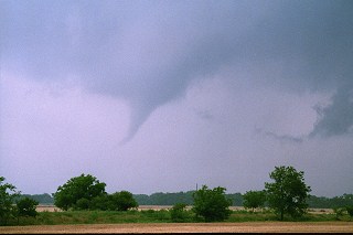 Photo provided courtesy of Dr. William Monfredo |
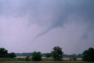 Photo provided courtesy of Dr. William Monfredo |
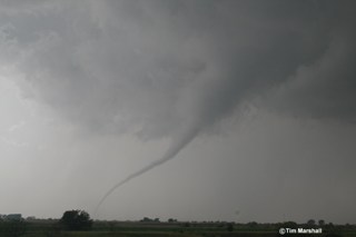 Photo provided courtesy of Tim Marshall |
Click on a time to jump to the product:
3:40 PM CDT - 3:52 PM CDT - 4:08 PM CDT - 4:22 PM CDT
WFUS54 KOUN 242040
TOROUN
OKC003-093-242145-
/O.NEW.KOUN.TO.W.0041.110524T2040Z-110524T2145Z/
BULLETIN - EAS ACTIVATION REQUESTED
TORNADO WARNING
NATIONAL WEATHER SERVICE NORMAN OK
340 PM CDT TUE MAY 24 2011
THE NATIONAL WEATHER SERVICE IN NORMAN HAS ISSUED A
* TORNADO WARNING FOR...
SOUTHERN ALFALFA COUNTY IN NORTHWEST OKLAHOMA...
EASTERN MAJOR COUNTY IN NORTHWEST OKLAHOMA...
* UNTIL 445 PM CDT
* AT 340 PM CDT...A THUNDERSTORM WITH A HISTORY OF PRODUCING
TORNADOES WAS LOCATED 8 MILES SOUTHWEST OF FAIRVIEW...MOVING
NORTHEAST AT 25 MPH.
* LOCATIONS IN THE WARNING INCLUDE ALINE...CARMEN...CLEO SPRINGS...
FAIRVIEW...GOLTRY...HELENA AND ORIENTA.
PRECAUTIONARY/PREPAREDNESS ACTIONS...
TAKE COVER NOW. LEAVE MOBILE HOMES AND VEHICLES. IF POSSIBLE...MOVE
TO A BASEMENT OR STORM SHELTER. OTHERWISE MOVE TO AN INTERIOR ROOM OR
HALLWAY ON THE LOWEST FLOOR. STAY AWAY FROM WINDOWS AND OUTSIDE
WALLS.
&&
LAT...LON 3656 9810 3617 9843 3617 9864 3659 9846
TIME...MOT...LOC 2040Z 207DEG 23KT 3619 9856
$$
WWUS54 KOUN 242052
SVSOUN
SEVERE WEATHER STATEMENT
NATIONAL WEATHER SERVICE NORMAN OK
352 PM CDT TUE MAY 24 2011
OKC003-093-242145-
/O.CON.KOUN.TO.W.0041.000000T0000Z-110524T2145Z/
ALFALFA OK-MAJOR OK-
352 PM CDT TUE MAY 24 2011
...A TORNADO WARNING REMAINS IN EFFECT UNTIL 445 PM CDT FOR CENTRAL
MAJOR AND SOUTHERN ALFALFA COUNTIES...
AT 352 PM CDT...A THUNDERSTORM WITH A HISTORY OF PRODUCING TORNADOES
WAS LOCATED NEAR FAIRVIEW...MOVING NORTHEAST AT 40 MPH. THE
DANGEROUS PORTION OF THIS STORM IS HEADED TOWARD ORIENTA AND CLEO
SPRINGS. TAKE COVER NOW!
* LOCATIONS IN THE WARNING INCLUDE ALINE...CARMEN...CLEO SPRINGS...
FAIRVIEW...GOLTRY...HELENA AND ORIENTA.
LAT...LON 3624 9837 3625 9859 3659 9846 3656 9810
TIME...MOT...LOC 2052Z 209DEG 35KT 3632 9847
$$
WWUS54 KOUN 242108
SVSOUN
SEVERE WEATHER STATEMENT
NATIONAL WEATHER SERVICE NORMAN OK
408 PM CDT TUE MAY 24 2011
OKC003-093-242145-
/O.CON.KOUN.TO.W.0041.000000T0000Z-110524T2145Z/
ALFALFA OK-MAJOR OK-
408 PM CDT TUE MAY 24 2011
...A TORNADO WARNING REMAINS IN EFFECT UNTIL 445 PM CDT FOR NORTHERN
MAJOR AND SOUTHERN ALFALFA COUNTIES...
AT 408 PM CDT...A THUNDERSTORM WITH A HISTORY OF PRODUCING TORNADOES
WAS LOCATED NEAR ORIENTA...MOVING NORTHEAST AT 35 MPH.
* LOCATIONS IN THE WARNING INCLUDE ALINE...CARMEN...CLEO SPRINGS...
GOLTRY...HELENA AND ORIENTA.
LAT...LON 3632 9838 3636 9853 3659 9846 3656 9810
TIME...MOT...LOC 2108Z 207DEG 29KT 3642 9842
$$
WWUS54 KOUN 242122
SVSOUN
SEVERE WEATHER STATEMENT
NATIONAL WEATHER SERVICE NORMAN OK
422 PM CDT TUE MAY 24 2011
OKC003-093-242132-
/O.CAN.KOUN.TO.W.0041.000000T0000Z-110524T2145Z/
ALFALFA OK-MAJOR OK-
422 PM CDT TUE MAY 24 2011
...THE TORNADO WARNING HAS BEEN CANCELLED FOR NORTHERN MAJOR AND
SOUTHERN ALFALFA COUNTIES...
THE STORM HAS WEAKENED... BUT SMALL HAIL AND GUSTY WINDS MAY STILL
OCCUR.
LAT...LON 3632 9838 3636 9853 3659 9846 3656 9810
TIME...MOT...LOC 2122Z 207DEG 29KT 3652 9836
$$
| Tornado Number |
Date | Time (CST) |
Length of Path (miles) |
Width of Path (yards) |
F-Scale | Killed | Injured | County | Location |
|---|---|---|---|---|---|---|---|---|---|
| B1 | 05/24/2011 | 1431-1446 | 9 | 800 | EF3 | 0 | 0 | Caddo | 4 WSW - 4 NE Lookeba |
This tornado damaged/destroyed several structures and mangled numerous many trees and power poles. The tornado dissipated near the Canadian County line, minutes before the storm produced another tornado in Canadian County that became the EF5 Calumet-El Reno-Piedmont-Guthrie tornado.
| Twin Lakes, OK (KTLX) Radar Relectivity and Storm Relative Velocity | |
|---|---|
 Combination Radar Relectivity and Storm Relative Velocity at 3:32 PM CDT on 5/24/2011") 3:32 PM CDT, 5/24/2011 |
 Combination Radar Relectivity and Storm Relative Velocity at 3:36 PM CDT on 5/24/2011") 3:36 PM CDT, 5/24/2011 |
3:53 PM CDT, 5/24/2011 |
|
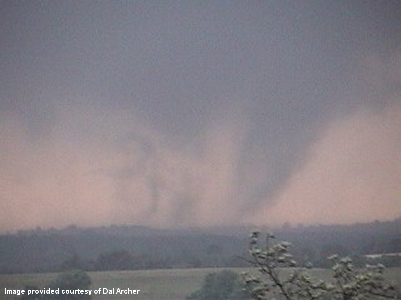 Photo provided courtesy of Dal Archer |
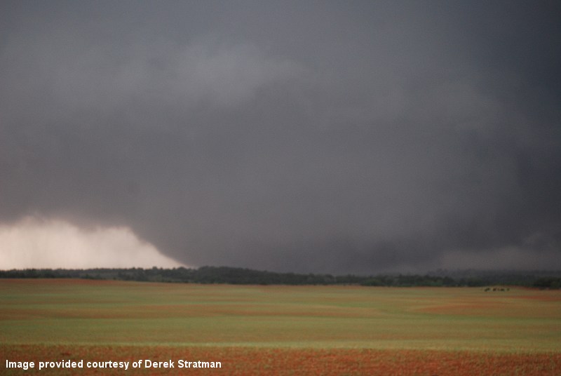 Photo provided courtesy of Derek Stratman |
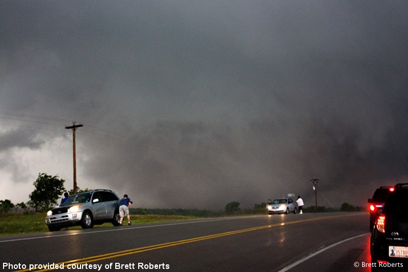 Photo provided courtesy of Brett Roberts |
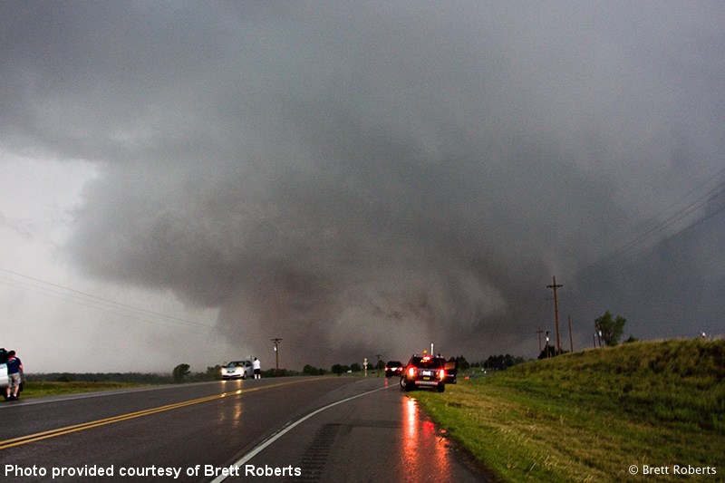 Photo provided courtesy of Brett Roberts |
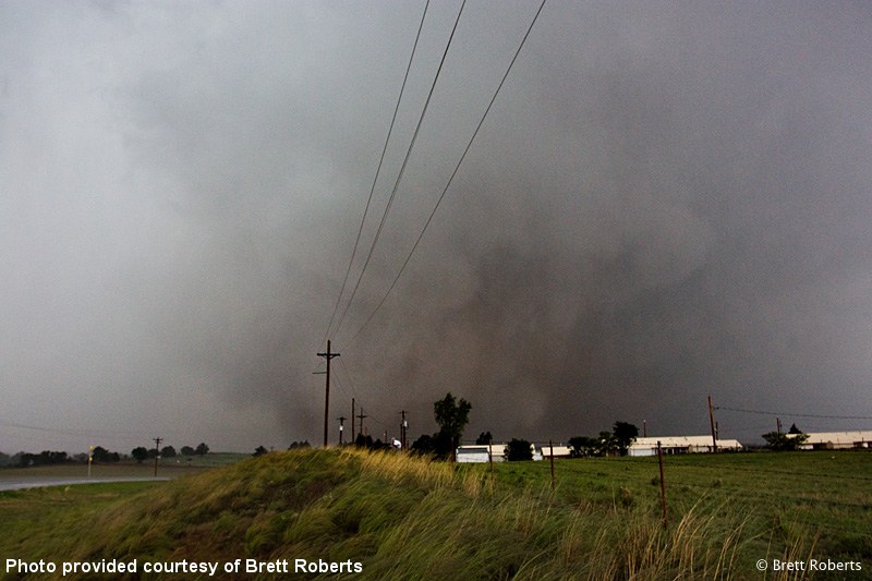 Photo provided courtesy of Brett Roberts |
3:07 PM CDT - 3:17 PM CDT - 3:28 PM CDT - 3:41 PM CDT - 3:55 PM CDT
WFUS54 KOUN 242007
TOROUN
OKC015-149-242100-
/O.NEW.KOUN.TO.W.0040.110524T2007Z-110524T2100Z/

BULLETIN - EAS ACTIVATION REQUESTED
TORNADO WARNING
NATIONAL WEATHER SERVICE NORMAN OK
307 PM CDT TUE MAY 24 2011

THE NATIONAL WEATHER SERVICE IN NORMAN HAS ISSUED A

* TORNADO WARNING FOR...
  NORTHWESTERN CADDO COUNTY IN SOUTHWEST OKLAHOMA...
  EASTERN WASHITA COUNTY IN WESTERN OKLAHOMA...

* UNTIL 400 PM CDT

* AT 308 PM CDT...NATIONAL WEATHER SERVICE RADAR INDICATED A SEVERE
  THUNDERSTORM CAPABLE OF PRODUCING A TORNADO 4 MILES SOUTHWEST OF
  ALFALFA...MOVING NORTHEAST AT 40 MPH.

* LOCATIONS IN THE WARNING INCLUDE ALBERT...ALFALFA...BINGER...
  BRIDGEPORT...CARNEGIE...COLONY...COWDEN...EAKLY...FORT COBB
  RESERVOIR...HINTON AND LOOKEBA.

THIS INCLUDES INTERSTATE 40 BETWEEN MILE MARKERS 90 AND 103.

PRECAUTIONARY/PREPAREDNESS ACTIONS...

TAKE COVER NOW. LEAVE MOBILE HOMES AND VEHICLES. IF POSSIBLE...MOVE
TO A BASEMENT OR STORM SHELTER. OTHERWISE MOVE TO AN INTERIOR ROOM OR
HALLWAY ON THE LOWEST FLOOR. STAY AWAY FROM WINDOWS AND OUTSIDE
WALLS.

&&

LAT...LON 3547 9866 3547 9863 3550 9862 3556 9853
      3555 9831 3538 9831 3538 9829 3530 9829
      3509 9861 3511 9861 3510 9863 3520 9878
TIME...MOT...LOC 2008Z 218DEG 35KT 3522 9862

$$
WWUS54 KOUN 242017
SVSOUN
SEVERE WEATHER STATEMENT
NATIONAL WEATHER SERVICE NORMAN OK
317 PM CDT TUE MAY 24 2011
OKC015-149-242100-
/O.CON.KOUN.TO.W.0040.000000T0000Z-110524T2100Z/
CADDO OK-WASHITA OK-
317 PM CDT TUE MAY 24 2011
...A TORNADO WARNING REMAINS IN EFFECT UNTIL 400 PM CDT FOR EASTERN
WASHITA AND NORTHWESTERN CADDO COUNTIES...
AT 316 PM CDT...NATIONAL WEATHER SERVICE RADAR DETECTED A SEVERE
THUNDERSTORM CAPABLE OF PRODUCING A TORNADO 3 MILES NORTHEAST OF
ALFALFA...MOVING NORTHEAST AT 40 MPH. THIS STORM IS MOVING TOWARDS
EAKLY.
* LOCATIONS IN THE WARNING INCLUDE ALBERT...ALFALFA...BINGER...
BRIDGEPORT...CARNEGIE...COLONY...COWDEN...EAKLY...FORT COBB
RESERVOIR...HINTON AND LOOKEBA.
THIS INCLUDES INTERSTATE 40 BETWEEN MILE MARKERS 90 AND 103.
PRECAUTIONARY/PREPAREDNESS ACTIONS...
IN ADDITION TO A TORNADO THREAT... THIS STORM LIKELY CONTAINS
DAMAGING HAIL TO THE SIZE OF BASEBALLS OR LARGER.
&&
LAT...LON 3547 9866 3547 9863 3550 9862 3556 9853
3555 9831 3538 9831 3538 9829 3530 9829
3509 9861 3511 9861 3510 9863 3520 9878
TIME...MOT...LOC 2016Z 218DEG 35KT 3528 9854
$$
WWUS54 KOUN 242028
SVSOUN
SEVERE WEATHER STATEMENT
NATIONAL WEATHER SERVICE NORMAN OK
328 PM CDT TUE MAY 24 2011
OKC149-242038-
/O.CAN.KOUN.TO.W.0040.000000T0000Z-110524T2100Z/
WASHITA OK-
328 PM CDT TUE MAY 24 2011
...THE TORNADO WARNING HAS BEEN CANCELLED FOR EASTERN WASHITA
COUNTY...
LAT...LON 3550 9861 3556 9853 3555 9852 3555 9831
3538 9831 3538 9829 3530 9829 3518 9853
3519 9856 3530 9862
TIME...MOT...LOC 2028Z 209DEG 35KT 3539 9847
$$
OKC015-242100-
/O.CON.KOUN.TO.W.0040.000000T0000Z-110524T2100Z/
CADDO OK-
328 PM CDT TUE MAY 24 2011
...A TORNADO WARNING REMAINS IN EFFECT UNTIL 400 PM CDT FOR
NORTHWESTERN CADDO COUNTY...
AT 328 PM CDT...NATIONAL WEATHER SERVICE RADAR DETECTED A SEVERE
THUNDERSTORM CAPABLE OF PRODUCING A TORNADO 6 MILES NORTHEAST OF
EAKLY...MOVING NORTHEAST AT 40 MPH. THIS STORM IS MOVING TOWARD
THE BRIDGEPORT AND HINTON AREAS. VERY LARGE HAIL TO BASEBALLS
ARE ALSO LIKELY WITH THIS STORM.
* LOCATIONS IN THE WARNING INCLUDE BINGER...BRIDGEPORT...EAKLY...
HINTON...LOOKEBA AND NORTHWESTERN FORT COBB RESERVOIR.
THIS INCLUDES INTERSTATE 40 BETWEEN MILE MARKERS 90 AND 103.
LAT...LON 3550 9861 3556 9853 3555 9852 3555 9831
3538 9831 3538 9829 3530 9829 3518 9853
3519 9856 3530 9862
TIME...MOT...LOC 2028Z 209DEG 35KT 3539 9847
$$
WFUS54 KOUN 242041
TOROUN
OKC011-015-017-242130-
/O.NEW.KOUN.TO.W.0042.110524T2041Z-110524T2130Z/

BULLETIN - EAS ACTIVATION REQUESTED
TORNADO WARNING
NATIONAL WEATHER SERVICE NORMAN OK
341 PM CDT TUE MAY 24 2011

THE NATIONAL WEATHER SERVICE IN NORMAN HAS ISSUED A

* TORNADO WARNING FOR...
  WESTERN CANADIAN COUNTY IN CENTRAL OKLAHOMA...
  SOUTHERN BLAINE COUNTY IN NORTHWEST OKLAHOMA...
  NORTHERN CADDO COUNTY IN SOUTHWEST OKLAHOMA...

* UNTIL 430 PM CDT

* AT 341 PM CDT...A LARGE... VIOLENT TORNADO WAS LOCATED 6 MILES
SOUTH OF HINTON...MOVING NORTHEAST AT 40 MPH.

* LOCATIONS IN THE WARNING INCLUDE BRIDGEPORT...CALUMET...CEDAR
  LAKE...GEARY AND HINTON.

LAT...LON 3571 9833 3572 9798 3547 9812 3534 9829
      3545 9848
TIME...MOT...LOC 2041Z 218DEG 35KT 3542 9836

$$
WWUS54 KOUN 242055
SVSOUN
SEVERE WEATHER STATEMENT
NATIONAL WEATHER SERVICE NORMAN OK
355 PM CDT TUE MAY 24 2011
OKC011-015-017-242130-
/O.CON.KOUN.TO.W.0042.000000T0000Z-110524T2130Z/
BLAINE OK-CANADIAN OK-CADDO OK-
355 PM CDT TUE MAY 24 2011
...A TORNADO WARNING REMAINS IN EFFECT UNTIL 430 PM CDT FOR NORTHERN
CADDO...WESTERN CANADIAN AND SOUTHERN BLAINE COUNTIES...
AT 350 PM CDT...RADAR CONTINUE TO INDICATE THE POSSIBILITY
OF A TORNADO JUST SOUTHEAST OF HINTON. THIS TORNADIC STORM WILL
LIKELY CROSS I-40 BETWEEN MILES MAKERS 111 AND 106. THE
STORMS ARE MOVING NORTHEAST AT 40 MPH.
* LOCATIONS IN THE WARNING INCLUDE BRIDGEPORT...CALUMET...CEDAR
LAKE...GEARY AND HINTON.
PRECAUTIONARY/PREPAREDNESS ACTIONS...
IN ADDITION TO A TORNADO THREAT... THIS STORM LIKELY CONTAINS
DAMAGING HAIL TO THE SIZE OF BASEBALLS OR LARGER.
&&
LAT...LON 3571 9833 3572 9798 3547 9812 3534 9829
3545 9848
TIME...MOT...LOC 2050Z 218DEG 35KT 3549 9829
$$
| Tornado Number |
Date | Time (CST) |
Length of Path (miles) |
Width of Path (yards) |
F-Scale | Killed | Injured | County | Location |
|---|---|---|---|---|---|---|---|---|---|
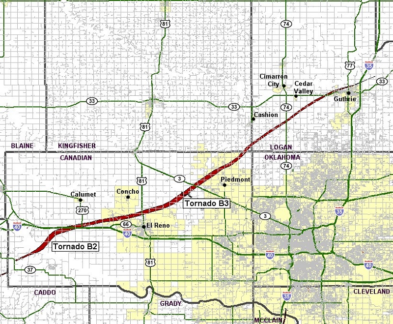
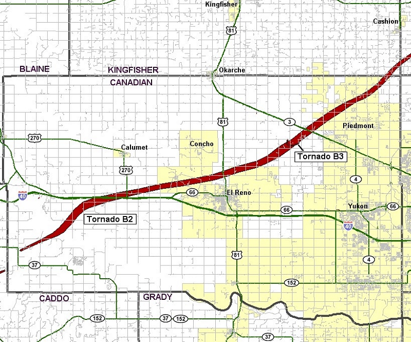
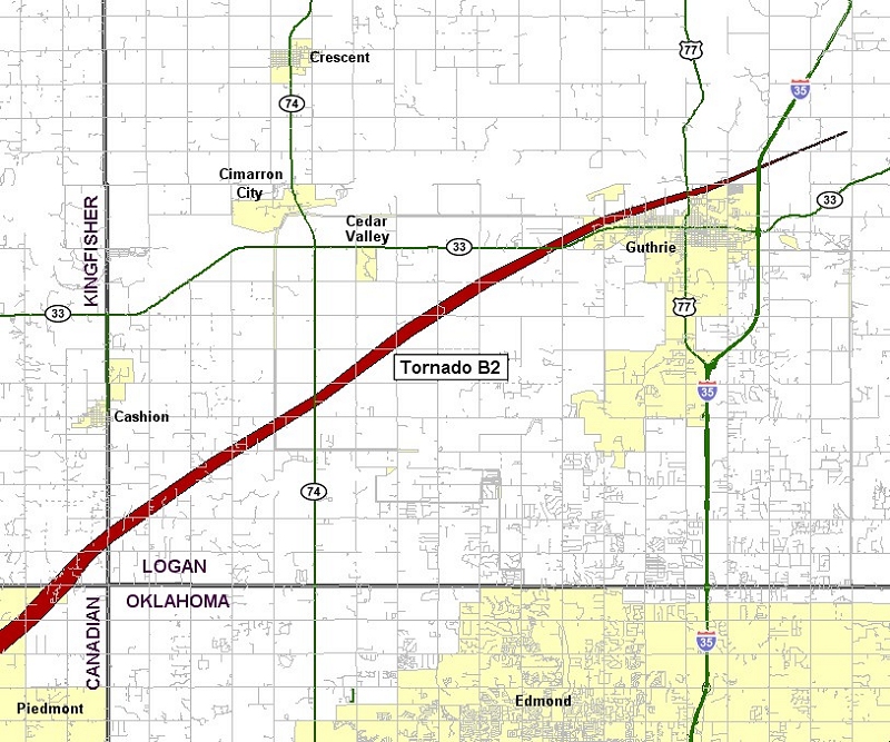
| B2 | 05/24/2011 | 1450-1635 | 63 | 1760 | EF5 | 9 | 181 | Canadian/ Kingfisher/ Logan | 4 ESE Hinton (14 SW Calumet) - near Calumet - El Reno - Piedmont - Cashion - 4 NE Guthrie |
This tornado began very close to the Caddo/Canadian County border and quickly became a strong/violent tornado. The tornado destroyed numerous trees, many of them were debarked, before crossing U.S. Interstate Highway 40. Three people died in vehicles near the I-40 Calumet exit, and two other fatalities occurred just northeast of that location. Cars were thrown thousands of feet off the roadways. It is believed that the tornado reached its maximum intensity just after crossing I-40, and it was here that a mobile radar measured winds of greater than 210 mph just off the surface.
The highest wind gust ever recorded at an Oklahoma Mesonet site was measured near El Reno, as an EF-5 tornado tore a path through Canadian County. The wind speed increased from 61 mph at 4:18 PM CDT, to 66 mph at 4:19 PM CDT, to 131 mph at 4:20 PM CDT, to 151 at 4:21 PM CDT, and then to 91 mph at 14:22 PM CDT. The tornado caused considerable damage to the area surrounding the Mesonet as it moved northeast.
As the tornado continued northeast, it narrowly missed the town of Piedmont. Widespread EF-3, occasional EF-4 damage occurred between El Reno and Piedmont. More widespread EF-4 damage was seen west and north of Piedmont. Especially hard hit was the Falcon Lake neighborhood, near the Kingfisher County border. Two children were killed at this location. The tornado continued into southeastern Kingfisher County.
The tornado entered far southeast Kingfisher County before moving into Logan County. However, EF-3 damage occurred just over the Kingfisher county border, debarking trees and significantly damaging buildings. As the tornado continued northeast, the damage was mainly considered EF-2, with damage to mostly outbuildings and trees.
The tornado moved into Logan County and resulted in two additional fatalities (both of whom were outside when the tornado struck) near Cashion. The tornado destroyed several manufactured homes (both double and single-wide) after entering Logan county. Large high-transmission line tresses collapsed. Trees were debarked with only stumps remaining. Several buildings had most of their exterior walls collapse, with only the inner walls remaining. EF-2 to occasionally EF-3 damage occurred as the tornado neared Guthrie. Luckily, most of the town of Guthrie was spared to the tornado as it moved west and then north of the center of the city. Finally, the tornado dissipated northeast of Guthrie with some minor tree damage. After it was all said and done, the tornado continued for 63 miles, and lasted around an hour and 45 minutes. Monetary damage estimates were not available.
| Twin Lakes, OK (KTLX) Radar Relectivity and Storm Relative Velocity | |
|---|---|
 Combination Radar Reflectivity and Storm Relative Velocity at 3:49 PM CDT on 5/24/2011") 3:49 PM CDT |
 Combination Radar Reflectivity and Storm Relative Velocity at 3:53 PM CDT on 5/24/2011") 3:53 PM CDT |
 Combination Radar Reflectivity and Storm Relative Velocity at 3:57 PM CDT on 5/24/2011") 3:57 PM CDT |
 Combination Radar Reflectivity and Storm Relative Velocity at 4:02 PM CDT on 5/24/2011") 4:02 PM CDT |
 Combination Radar Reflectivity and Storm Relative Velocity at 4:06 PM CDT on 5/24/2011") 4:06 PM CDT |
 Combination Radar Reflectivity and Storm Relative Velocity at 4:10 PM CDT on 5/24/2011") 4:10 PM CDT |
 Combination Radar Reflectivity and Storm Relative Velocity at 4:14 PM CDT on 5/24/2011") 4:14 PM CDT |
 Combination Radar Reflectivity and Storm Relative Velocity at 4:18 PM CDT on 5/24/2011") 4:18 PM CDT |
 Combination Radar Reflectivity and Storm Relative Velocity at 4:23 PM CDT on 5/24/2011") 4:23 PM CDT |
 Combination Radar Reflectivity and Storm Relative Velocity at 4:27 PM CDT on 5/24/2011") 4:27 PM CDT |
 Combination Radar Reflectivity and Storm Relative Velocity at 4:31 PM CDT on 5/24/2011") 4:31 PM CDT |
 Combination Radar Reflectivity and Storm Relative Velocity at 4:36 PM CDT on 5/24/2011") 4:36 PM CDT |
 Combination Radar Reflectivity and Storm Relative Velocity at 4:40 PM CDT on 5/24/2011") 4:40 PM CDT |
 Combination Radar Reflectivity and Storm Relative Velocity at 4:44 PM CDT on 5/24/2011") 4:44 PM CDT |
 Combination Radar Reflectivity and Storm Relative Velocity at 4:48 PM CDT on 5/24/2011") 4:48 PM CDT |
 Combination Radar Reflectivity and Storm Relative Velocity at 4:52 PM CDT on 5/24/2011") 4:52 PM CDT |
 Combination Radar Reflectivity and Storm Relative Velocity at 4:57 PM CDT on 5/24/2011") 4:57 PM CDT |
 Combination Radar Reflectivity and Storm Relative Velocity at 5:01 PM CDT on 5/24/2011") 5:01 PM CDT |
 Combination Radar Reflectivity and Storm Relative Velocity at 5:05 PM CDT on 5/24/2011") 5:05 PM CDT |
 Combination Radar Reflectivity and Storm Relative Velocity at 5:10 PM CDT on 5/24/2011") 5:10 PM CDT |
 Combination Radar Reflectivity and Storm Relative Velocity at 5:14 PM CDT on 5/24/2011") 5:14 PM CDT |
 Combination Radar Reflectivity and Storm Relative Velocity at 5:18 PM CDT on 5/24/2011") 5:18 PM CDT |
 Combination Radar Reflectivity and Storm Relative Velocity at 5:22 PM CDT on 5/24/2011") 5:22 PM CDT |
 Combination Radar Reflectivity and Storm Relative Velocity at 5:27 PM CDT on 5/24/2011") 5:27 PM CDT |
 Combination Radar Reflectivity and Storm Relative Velocity at 5:31 PM CDT on 5/24/2011") 5:31 PM CDT |
 Combination Radar Reflectivity and Storm Relative Velocity at 5:35 PM CDT on 5/24/2011") 5:35 PM CDT |
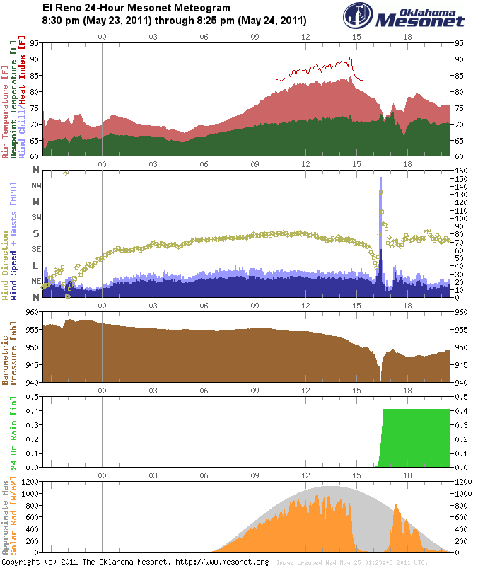
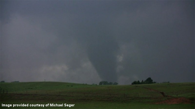 Photo provided courtesy of Michael Seger |
 Photo provided courtesy of Michael Seger |
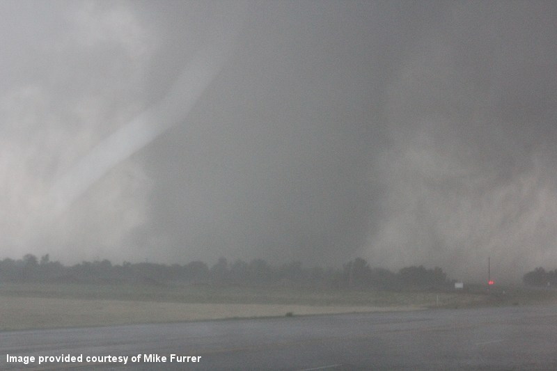 Photo provided courtesy of Mike Furrer |
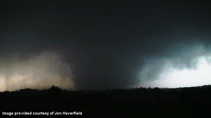 Photo provided courtesy of Jon Haverfield |
 |
 |
 |
 |
 |
 |
 |
 |
 |
 |
 |
 |
 |
 |
 |
 |
 |
 |
 |
 |
 |
 |
 |
 |
 |
 |
 |
 |
 |
 |
 |
 |
 |
3:41 PM CDT - 3:55 PM CDT - 4:00 PM CDT - 4:13 PM CDT - 4:24 PM CDT - 4:32 PM CDT - 4:56 PM CDT - 5:08 PM CDT - 5:21 PM CDT - 5:33 PM CDT
WFUS54 KOUN 242041
TOROUN
OKC011-015-017-242130-
/O.NEW.KOUN.TO.W.0042.110524T2041Z-110524T2130Z/
BULLETIN - EAS ACTIVATION REQUESTED
TORNADO WARNING
NATIONAL WEATHER SERVICE NORMAN OK
341 PM CDT TUE MAY 24 2011
THE NATIONAL WEATHER SERVICE IN NORMAN HAS ISSUED A
* TORNADO WARNING FOR...
WESTERN CANADIAN COUNTY IN CENTRAL OKLAHOMA...
SOUTHERN BLAINE COUNTY IN NORTHWEST OKLAHOMA...
NORTHERN CADDO COUNTY IN SOUTHWEST OKLAHOMA...
* UNTIL 430 PM CDT
* AT 341 PM CDT...A LARGE... VIOLENT TORNADO WAS LOCATED 6 MILES
SOUTH OF HINTON...MOVING NORTHEAST AT 40 MPH.
* LOCATIONS IN THE WARNING INCLUDE BRIDGEPORT...CALUMET...CEDAR
LAKE...GEARY AND HINTON.
LAT...LON 3571 9833 3572 9798 3547 9812 3534 9829
3545 9848
TIME...MOT...LOC 2041Z 218DEG 35KT 3542 9836
$$
| Tornado Number |
Date | Time (CST) |
Length of Path (miles) |
Width of Path (yards) |
F-Scale | Killed | Injured | County | Location |
|---|---|---|---|---|---|---|---|---|---|
| B3 | 05/24/2011 | 1537-1539 | 1.5 | 50 | EF0 | 0 | 0 | Canadian | 3 NW Richland |
A Storm Prediction Center employee observed a satellite tornado rotating around the primary Calumet-El Reno-Piedmont-Guthrie tornado for a couple of minutes to the northwest of Richland. This tornado produced no known damage that was distinguished from the primary tornado.
| Twin Lakes, OK (KTLX) Radar Relectivity and Storm Relative Velocity | |
|---|---|
4:36 PM CDT |
4:40 PM CDT |
WWUS54 KOUN 242132
SVSOUN

SEVERE WEATHER STATEMENT
NATIONAL WEATHER SERVICE NORMAN OK
432 PM CDT TUE MAY 24 2011

OKC017-242145-
/O.CON.KOUN.TO.W.0044.000000T0000Z-110524T2145Z/
CANADIAN OK-
432 PM CDT TUE MAY 24 2011

...A TORNADO WARNING REMAINS IN EFFECT UNTIL 445 PM CDT FOR
NORTHEASTERN CANADIAN COUNTY...

AT 431 PM CDT...A LARGE...VIOLENT TORNADO WAS LOCATED IN THE
NORTHERN PARTS OF EL RENO...MOVING EAST-NORTHEAST AT 30 MPH. PERSONS
IN EL RENO...PIEDMONT...AND NORTHERN YUKON NEED TO BE TAKING
SHELTER! THIS IS A VERY DANGEROUS SITUATION!

* LOCATIONS IN THE WARNING INCLUDE CONCHO...EL RENO...NORTHWESTERN
  OKLAHOMA CITY...OKARCHE...PIEDMONT AND RICHLAND.

LAT...LON 3573 9806 3573 9779 3573 9767 3552 9767
      3551 9800 3556 9809
TIME...MOT...LOC 2131Z 256DEG 26KT 3558 9793

$$
This tornado developed with mainly tree and power pole/line damage. The tree damage was significant, with several homes impacted as the tornado traveled northeast. Significant roof and siding damage occurred to the homes, with several barns and outbuildings sustaining significant damage or were destroyed altogether. EF-2 damage continued as the tornado moved south of Stillwater, with additional structures sustaining roof damage. A couple of the homes also had collapsed chimneys. The damage lessened in severity over the latter half of the tornado path, with mostly tree damage and minor structural damage.
| Twin Lakes, OK (KTLX) Radar Relectivity and Storm Relative Velocity | |
|---|---|
 Combination Radar Reflectivity and Storm Relative Velocity at 5:48 PM CDT on 5/24/2011") 5:48 PM CDT |
 Combination Radar Reflectivity and Storm Relative Velocity at 5:52 PM CDT on 5/24/2011") 5:52 PM CDT |
 Combination Radar Reflectivity and Storm Relative Velocity at 5:56 PM CDT on 5/24/2011") 5:56 PM CDT |
 Combination Radar Reflectivity and Storm Relative Velocity at 6:00 PM CDT on 5/24/2011") 6:00 PM CDT |
 Combination Radar Reflectivity and Storm Relative Velocity at 6:05 PM CDT on 5/24/2011") 6:05 PM CDT |
 Combination Radar Reflectivity and Storm Relative Velocity at 6:10 PM CDT on 5/24/2011") 6:10 PM CDT |
5:33 PM CDT - 5:49 PM CDT - 6:07 PM CDT - 6:27 PM CDT
BULLETIN - EAS ACTIVATION REQUESTED
TORNADO WARNING
NATIONAL WEATHER SERVICE NORMAN OK
533 PM CDT TUE MAY 24 2011

THE NATIONAL WEATHER SERVICE IN NORMAN HAS ISSUED A

* TORNADO WARNING FOR...
  CENTRAL LOGAN COUNTY IN CENTRAL OKLAHOMA...
  PAYNE COUNTY IN CENTRAL OKLAHOMA...
  SOUTHEASTERN NOBLE COUNTY IN NORTHERN OKLAHOMA...

* UNTIL 630 PM CDT

* AT 533 PM CDT...A LARGE... VIOLENT TORNADO WAS LOCATED NEAR
  GUTHRIE...MOVING NORTHEAST AT 35 MPH.

* LOCATIONS IN THE WARNING INCLUDE COYLE...GLENCOE...GUTHRIE...
  INGALLS...LAKE CARL BLACKWELL...LAKE MCMURTRY...LANGSTON...
  MORRISON...PERKINS...QUAY...RIPLEY...SOONER LAKE...STILLWATER AND
  YALE.

THIS INCLUDES INTERSTATE 35 BETWEEN MILE MARKERS 157 AND 175.

PRECAUTIONARY/PREPAREDNESS ACTIONS...

THIS IS AN EXTREMELY DANGEROUS AND LIFE THREATENING SITUATION. IF YOU
ARE IN THE PATH OF THIS LARGE AND DESTRUCTIVE TORNADO... TAKE COVER
IMMEDIATELY. A BASEMENT OR STORM SHELTER IS BEST. OTHERWISE...TAKE
COVER IN AN INTERIOR CLOSET OR BATHROOM AWAY FROM OUTSIDE WALLS AND
WINDOWS. COVER YOUR HEAD WITH PILLOWS AND BLANKETS.

&&

LAT...LON 3635 9702 3635 9695 3633 9691 3626 9691
      3626 9683 3624 9681 3617 9681 3618 9663
      3617 9661 3610 9662 3585 9740 3594 9751
      3646 9703
TIME...MOT...LOC 2233Z 235DEG 30KT 3591 9741

$$
WWUS54 KOUN 242249
SVSOUN
SEVERE WEATHER STATEMENT
NATIONAL WEATHER SERVICE NORMAN OK
549 PM CDT TUE MAY 24 2011
OKC083-103-119-242330-
/O.CON.KOUN.TO.W.0052.000000T0000Z-110524T2330Z/
LOGAN OK-NOBLE OK-PAYNE OK-
549 PM CDT TUE MAY 24 2011
...A TORNADO WARNING REMAINS IN EFFECT UNTIL 630 PM CDT FOR PAYNE...
SOUTHEASTERN NOBLE AND CENTRAL LOGAN COUNTIES...
AT 549 PM CDT...A THUNDERSTORM WITH A HISTORY OF PRODUCING TORNADOES
WAS LOCATED 3 MILES NORTH OF COYLE...MOVING NORTHEAST AT 40 MPH.
THIS IS A VERY DANGEROUS STORM AND IS HEADING TOWARD STILLWATER.
TAKE COVER NOW!
* LOCATIONS IN THE WARNING INCLUDE COYLE...GLENCOE...INGALLS...LAKE
CARL BLACKWELL...LAKE MCMURTRY...LANGSTON...MORRISON...QUAY...
RIPLEY...SOONER LAKE...STILLWATER AND YALE.
THIS INCLUDES INTERSTATE 35 BETWEEN MILE MARKERS 163 AND 173.
PRECAUTIONARY/PREPAREDNESS ACTIONS...
THIS IS AN EXTREMELY DANGEROUS AND LIFE THREATENING SITUATION. IF YOU
ARE IN THE PATH OF THIS LARGE AND DESTRUCTIVE TORNADO... TAKE COVER
IMMEDIATELY. A BASEMENT OR STORM SHELTER IS BEST. OTHERWISE...TAKE
COVER IN AN INTERIOR CLOSET OR BATHROOM AWAY FROM OUTSIDE WALLS AND
WINDOWS. COVER YOUR HEAD WITH PILLOWS AND BLANKETS.
&&
LAT...LON 3588 9734 3601 9742 3646 9703 3635 9702
3635 9695 3633 9691 3626 9691 3626 9683
3624 9681 3617 9681 3618 9663 3617 9661
3610 9662
TIME...MOT...LOC 2249Z 237DEG 37KT 3601 9722
$$
WWUS54 KOUN 242307
SVSOUN
SEVERE WEATHER STATEMENT
NATIONAL WEATHER SERVICE NORMAN OK
607 PM CDT TUE MAY 24 2011
OKC083-242316-
/O.CAN.KOUN.TO.W.0052.000000T0000Z-110524T2330Z/
LOGAN OK-
607 PM CDT TUE MAY 24 2011
...THE TORNADO WARNING HAS BEEN CANCELLED FOR CENTRAL LOGAN COUNTY...
THE STORM HAS MOVED EAST OF THE COUNTY.
LAT...LON 3596 9710 3612 9726 3646 9703 3635 9702
3635 9695 3633 9691 3626 9691 3626 9683
3624 9681 3617 9681 3618 9663 3617 9661
3610 9662
TIME...MOT...LOC 2306Z 239DEG 38KT 3610 9702
$$
OKC103-119-242330-
/O.CON.KOUN.TO.W.0052.000000T0000Z-110524T2330Z/
NOBLE OK-PAYNE OK-
607 PM CDT TUE MAY 24 2011
...A TORNADO WARNING REMAINS IN EFFECT UNTIL 630 PM CDT FOR PAYNE AND
SOUTHEASTERN NOBLE COUNTIES...
AT 606 PM CDT...A THUNDERSTORM WITH A HISTORY OF PRODUCING TORNADOES
WAS LOCATED NEAR STILLWATER...MOVING NORTHEAST AT 45 MPH. THE MOST
DANGEROUS PART OF THE STORM WAS LOCATED ACROSS THE SOUTH SIDES OF
STILLWATER.
* LOCATIONS IN THE WARNING INCLUDE GLENCOE...INGALLS...LAKE CARL
BLACKWELL...LAKE MCMURTRY...MORRISON...QUAY...SOONER LAKE...
STILLWATER AND YALE.
PRECAUTIONARY/PREPAREDNESS ACTIONS...
THIS IS AN EXTREMELY DANGEROUS AND LIFE THREATENING SITUATION. IF YOU
ARE IN THE PATH OF THIS LARGE AND DESTRUCTIVE TORNADO... TAKE COVER
IMMEDIATELY. A BASEMENT OR STORM SHELTER IS BEST. OTHERWISE...TAKE
COVER IN AN INTERIOR CLOSET OR BATHROOM AWAY FROM OUTSIDE WALLS AND
WINDOWS. COVER YOUR HEAD WITH PILLOWS AND BLANKETS.
&&
LAT...LON 3596 9710 3612 9726 3646 9703 3635 9702
3635 9695 3633 9691 3626 9691 3626 9683
3624 9681 3617 9681 3618 9663 3617 9661
3610 9662
TIME...MOT...LOC 2306Z 239DEG 38KT 3610 9702
$$
WWUS54 KOUN 242327
SVSOUN
SEVERE WEATHER STATEMENT
NATIONAL WEATHER SERVICE NORMAN OK
627 PM CDT TUE MAY 24 2011
OKC103-119-242335-
/O.EXP.KOUN.TO.W.0052.000000T0000Z-110524T2330Z/
NOBLE OK-PAYNE OK-
627 PM CDT TUE MAY 24 2011
...THE TORNADO WARNING FOR PAYNE AND SOUTHEASTERN NOBLE COUNTIES WILL
EXPIRE AT 630 PM CDT...
THE TORNADIC PORTION OF THE STORM HAS MOVED OUT OF NOBLE AND PAYNE
COUNTIES.
LAT...LON 3596 9710 3612 9726 3646 9703 3635 9702
3635 9695 3633 9691 3626 9691 3626 9683
3624 9681 3617 9681 3618 9663 3617 9661
3610 9662
TIME...MOT...LOC 2325Z 239DEG 38KT 3620 9681
$$
| Tornado Number |
Date | Time (CST) |
Length of Path (miles) |
Width of Path (yards) |
F-Scale | Killed | Injured | County | Location |
|---|---|---|---|---|---|---|---|---|---|
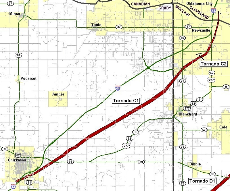
| C1 | 05/24/2011 | 1606-1701 | 33 | 880 | EF4 | 1 | 48 | Grady/ McClain/ Cleveland | 2 S Chickasha - SW Oklahoma City (near SW 149th and Portland) |
This tornado formed on the south side of Chickasha in Grady County, quickly producing EF-2 damage. Mobile homes were damaged and destroyed, trees were uprooted/destroyed, outbuildings were destroyed, and many buildings lost significant portions of their roofs. One fatality occurred as a mobile home was destroyed in the south portion of Chickasha. As the tornado moved northeast of Chickasha, it gained significant strength, with several areas receiving EF-4 damage. Well-built homes were destroyed. Trees were debarked with only stumps remaining. Cars were thrown hundreds of feet. Almost continuous EF-3/occasional EF-4 damage occurred northeast until it crossed into McClain County 1.5 miles south of Highway 9. The tornado was probably at its strongest as it neared/crossed the McClain county line. Wind speeds there were estimated near 200 mph.
Significant damage continued as the violent tornado crossed over the McClain County line. This may have been the strongest portion of this tornado, with wind speeds near 200 mph. Well-built homes were destroyed, with some cleaned off of their foundation. A concrete dome home was severely damage, mainly by the flying debris. Trees were debarked or destroyed. Very little was left standing for the first few miles into McClain County. Fairly consistent EF-3, with brief periods of EF-4 damage occurred as the tornado neared/crossed Highway 9, near the Highway 76 junction. The tornado began to weaken as it moved toward the Cleveland County border, with mainly trees and power poles/lines snapped.
As the tornado continued into Cleveland County, only minor tree/power pole/power line damage occurred just inside the Cleveland County line. A few barns and outbuilding also sustained minor damage east of I-44. The tornado dissipated just north of the Canadian River. After it was finally over, the tornado continued for just under an hour, with a length of around 32 miles. Peak wind speeds were estimated just under 200 mph. Monetary damage estimates were not available.
| Twin Lakes, OK (KTLX) Radar Relectivity and Storm Relative Velocity | |
|---|---|
 Combination Radar Reflectivity and Storm Relative Velocity at 5:10 PM CDT on 5/24/2011") 5:10 PM CDT |
 Combination Radar Reflectivity and Storm Relative Velocity at 5:14 PM CDT on 5/24/2011") 5:14 PM CDT |
 Combination Radar Reflectivity and Storm Relative Velocity at 5:18 PM CDT on 5/24/2011") 5:18 PM CDT |
 Combination Radar Reflectivity and Storm Relative Velocity at 5:22 PM CDT on 5/24/2011") 5:22 PM CDT |
 Combination Radar Reflectivity and Storm Relative Velocity at 5:26 PM CDT on 5/24/2011") 5:26 PM CDT |
 Combination Radar Reflectivity and Storm Relative Velocity at 5:31 PM CDT on 5/24/2011") 5:31 PM CDT |
 Combination Radar Reflectivity and Storm Relative Velocity at 5:35 PM CDT on 5/24/2011") 5:35 PM CDT |
 Combination Radar Reflectivity and Storm Relative Velocity at 5:39 PM CDT on 5/24/2011") 5:39 PM CDT |
 Combination Radar Reflectivity and Storm Relative Velocity at 5:44 PM CDT on 5/24/2011") 5:44 PM CDT |
 Combination Radar Reflectivity and Storm Relative Velocity at 5:48 PM CDT on 5/24/2011") 5:48 PM CDT |
 Combination Radar Reflectivity and Storm Relative Velocity at 5:52 PM CDT on 5/24/2011") 5:52 PM CDT |
 Combination Radar Reflectivity and Storm Relative Velocity at 5:56 PM CDT on 5/24/2011") 5:56 PM CDT |
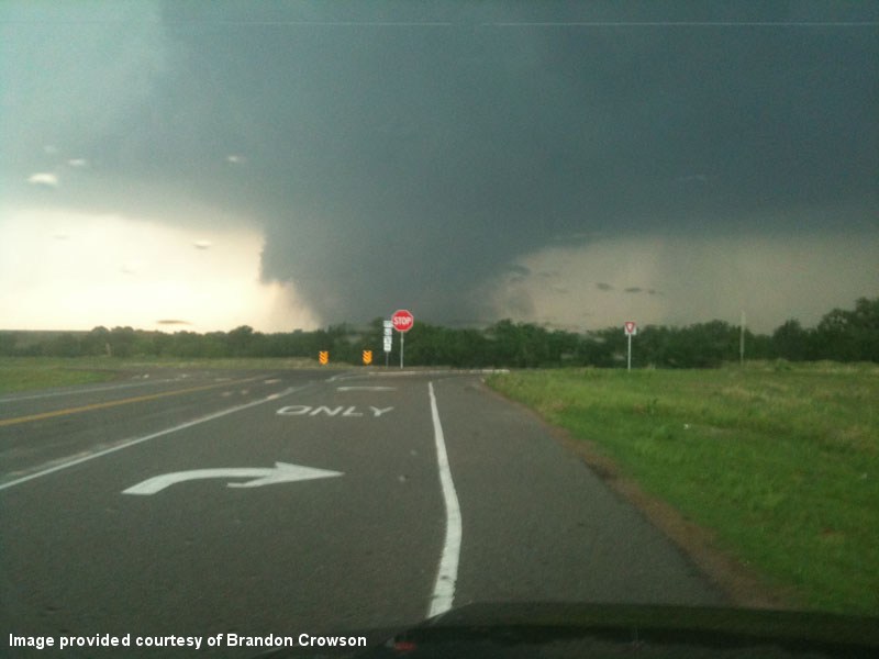 Photo courtesy of Brandon Crowson |
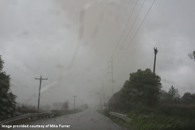 Photo courtesy of Mike Furrer |
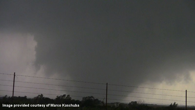 Photo courtesy of Marco Kaschuba |
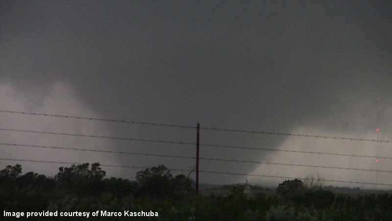 Photo courtesy of Marco Kaschuba |
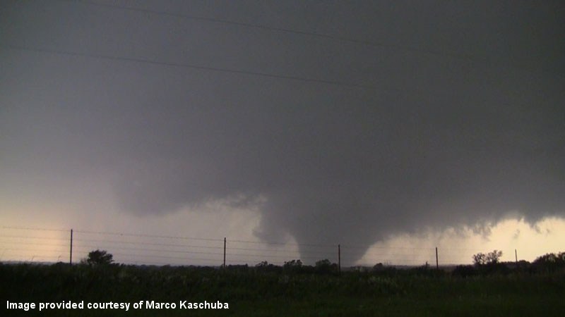 Photo courtesy of Marco Kaschuba |
 Photo courtesy of Tom Pastrano |
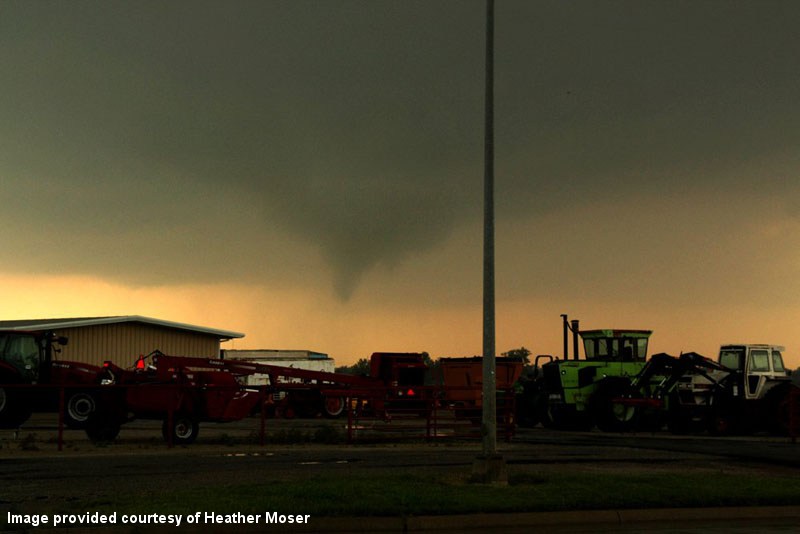 Photo courtesy of Heather Moser |
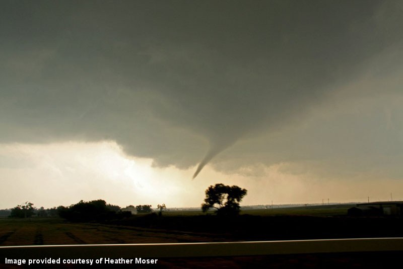 Photo courtesy of Heather Moser |
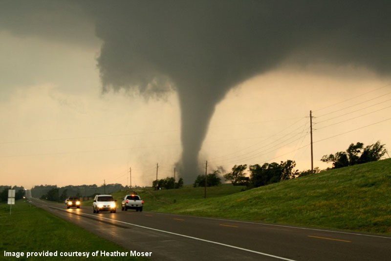 Photo courtesy of Heather Moser |
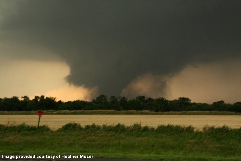 Photo courtesy of Heather Moser |
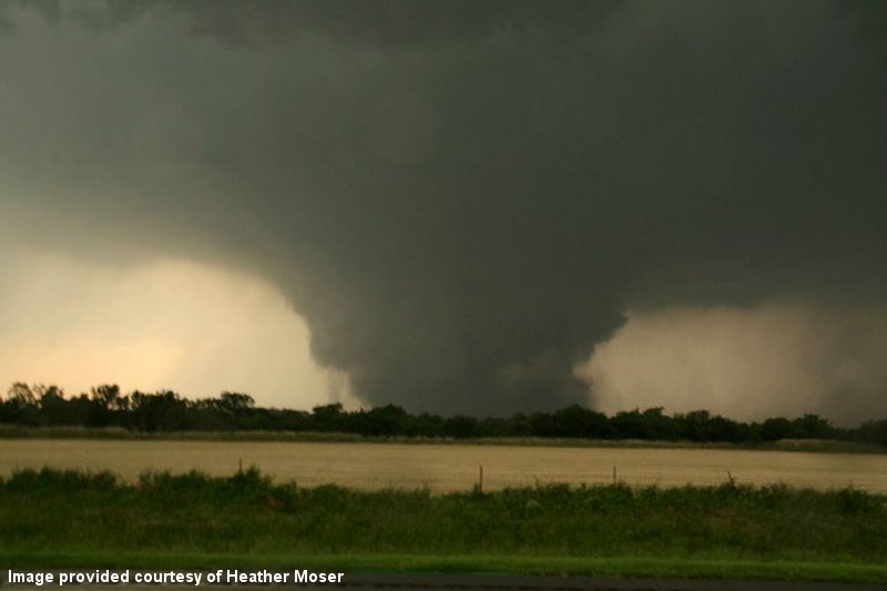 Photo courtesy of Heather Moser |
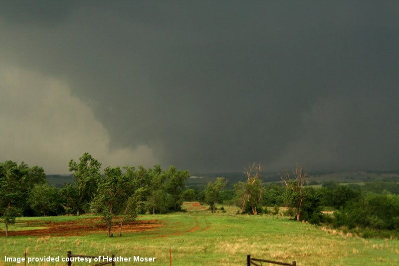 Photo courtesy of Heather Moser |
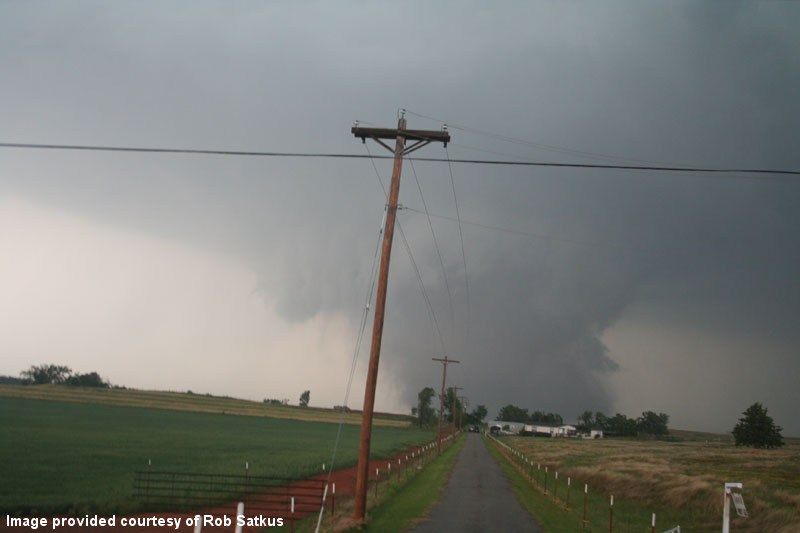 Photo courtesy of Rob Satkus |
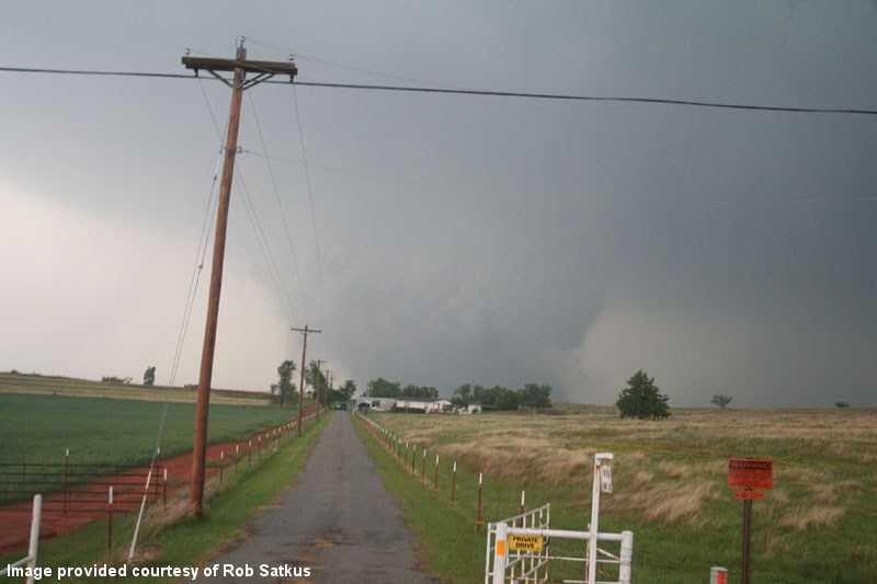 Photo courtesy of Rob Satkus |
 |
 |
 |
4:50 PM CDT - 5:13 PM CDT - 5:18 PM CDT - 5:55 PM CDT
WFUS54 KOUN 242150
TOROUN
OKC015-017-051-242230-
/O.NEW.KOUN.TO.W.0047.110524T2150Z-110524T2230Z/

BULLETIN - EAS ACTIVATION REQUESTED
TORNADO WARNING
NATIONAL WEATHER SERVICE NORMAN OK
450 PM CDT TUE MAY 24 2011

THE NATIONAL WEATHER SERVICE IN NORMAN HAS ISSUED A

* TORNADO WARNING FOR...
  EXTREME SOUTHEASTERN CANADIAN COUNTY IN CENTRAL OKLAHOMA...
  NORTHERN GRADY COUNTY IN CENTRAL OKLAHOMA...
  SOUTHEASTERN CADDO COUNTY IN SOUTHWEST OKLAHOMA...

* UNTIL 530 PM CDT

* AT 450 PM CDT...NATIONAL WEATHER SERVICE RADAR INDICATED A SEVERE
  THUNDERSTORM CAPABLE OF PRODUCING A TORNADO NEAR CEMENT...MOVING
  NORTHEAST AT 50 MPH.

* LOCATIONS IN THE WARNING INCLUDE AMBER...BRIDGE CREEK...CEMENT...
  CHICKASHA...LAVERTY...MIDDLEBERG...NORGE...POCASSET...SOUTHWESTERN
  OKLAHOMA CITY...TABLER AND TUTTLE.

THIS INCLUDES INTERSTATE 44 BETWEEN MILE MARKERS 67 AND 101.

PRECAUTIONARY/PREPAREDNESS ACTIONS...

TAKE COVER NOW. LEAVE MOBILE HOMES AND VEHICLES. IF POSSIBLE...MOVE
TO A BASEMENT OR STORM SHELTER. OTHERWISE MOVE TO AN INTERIOR ROOM OR
HALLWAY ON THE LOWEST FLOOR. STAY AWAY FROM WINDOWS AND OUTSIDE
WALLS.

&&

LAT...LON 3490 9822 3534 9786 3538 9768 3509 9767
      3490 9802 3488 9810
TIME...MOT...LOC 2150Z 214DEG 41KT 3497 9809

$$
WWUS54 KOUN 242213 RRA
SVSOUN
SEVERE WEATHER STATEMENT
NATIONAL WEATHER SERVICE NORMAN OK
513 PM CDT TUE MAY 24 2011
OKC015-242222-
/O.CAN.KOUN.TO.W.0047.000000T0000Z-110524T2230Z/
CADDO OK-
513 PM CDT TUE MAY 24 2011
...THE TORNADO WARNING HAS BEEN CANCELLED FOR SOUTHEASTERN CADDO
COUNTY...
LAT...LON 3494 9801 3497 9809 3499 9809 3534 9786
3538 9768 3509 9767 3490 9802
TIME...MOT...LOC 2212Z 222DEG 33KT 3503 9791
$$
OKC017-051-242230-
/O.CON.KOUN.TO.W.0047.000000T0000Z-110524T2230Z/
CANADIAN OK-GRADY OK-
513 PM CDT TUE MAY 24 2011
...A TORNADO WARNING REMAINS IN EFFECT UNTIL 530 PM CDT FOR NORTHERN
GRADY AND EXTREME SOUTHEASTERN CANADIAN COUNTIES...
AT 512 PM CDT...RADAR AND STORM SPOTTERS OBSERVED A TORNADO NEAR
INTERSTAE 44 APPROACHING HIGHWAY 9. PEOPLE IN CHICKASHA SHOULD TAKE
IMMEDIATE TORNADO PRECAUTIONS.
* LOCATIONS IN THE WARNING INCLUDE AMBER...BRIDGE CREEK...
CHICKASHA...LAVERTY...MIDDLEBERG...NORGE...POCASSET...SOUTHWESTERN
OKLAHOMA CITY...TABLER AND TUTTLE.
THIS INCLUDES INTERSTATE 44 BETWEEN MILE MARKERS 74 AND 101.
PRECAUTIONARY/PREPAREDNESS ACTIONS...
TAKE COVER NOW. LEAVE MOBILE HOMES AND VEHICLES. IF POSSIBLE...MOVE
TO A BASEMENT OR STORM SHELTER. OTHERWISE MOVE TO AN INTERIOR ROOM OR
HALLWAY ON THE LOWEST FLOOR. STAY AWAY FROM WINDOWS AND OUTSIDE
WALLS.
&&
LAT...LON 3494 9801 3497 9809 3499 9809 3534 9786
3538 9768 3509 9767 3490 9802
TIME...MOT...LOC 2212Z 222DEG 33KT 3503 9791
$$
WWUS54 KOUN 242218
SVSOUN

SEVERE WEATHER STATEMENT
NATIONAL WEATHER SERVICE NORMAN OK
518 PM CDT TUE MAY 24 2011

OKC017-051-242230-
/O.CON.KOUN.TO.W.0047.000000T0000Z-110524T2230Z/
CANADIAN OK-GRADY OK-
518 PM CDT TUE MAY 24 2011

...A TORNADO WARNING REMAINS IN EFFECT UNTIL 530 PM CDT FOR NORTHERN
GRADY AND EXTREME SOUTHEASTERN CANADIAN COUNTIES...

AT 516 PM CDT...A THUNDERSTORM WITH A HISTORY OF PRODUCING TORNADOES
WAS LOCATED OVER NORTHEAST PARTS OF CHICKASHA...MOVING NORTHEAST AT
40 MPH. THIS STORM WILL LIKELY TRACK ALONG I-44 TOWARD BRIDGE
CREEK AND NEW CASTLE.


* LOCATIONS IN THE WARNING INCLUDE AMBER...BRIDGE CREEK...
  CHICKASHA...LAVERTY...MIDDLEBERG...NORGE...POCASSET...SOUTHWESTERN
  OKLAHOMA CITY...TABLER AND TUTTLE.

THIS INCLUDES INTERSTATE 44 BETWEEN MILE MARKERS 73 AND 101.

LAT...LON 3494 9801 3497 9809 3499 9809 3534 9786
      3538 9768 3509 9767 3490 9802
TIME...MOT...LOC 2216Z 222DEG 33KT 3506 9788

$$
WFUS54 KOUN 242223
TOROUN
OKC027-051-087-242300-
/O.NEW.KOUN.TO.W.0050.110524T2223Z-110524T2300Z/
BULLETIN - EAS ACTIVATION REQUESTED
TORNADO WARNING
NATIONAL WEATHER SERVICE NORMAN OK
523 PM CDT TUE MAY 24 2011
THE NATIONAL WEATHER SERVICE IN NORMAN HAS ISSUED A
* TORNADO WARNING FOR...
NORTHWESTERN CLEVELAND COUNTY IN CENTRAL OKLAHOMA...
NORTHEASTERN GRADY COUNTY IN CENTRAL OKLAHOMA...
NORTHWESTERN MCCLAIN COUNTY IN CENTRAL OKLAHOMA...
* UNTIL 600 PM CDT
* AT 522 PM CDT...A SEVERE THUNDERSTORM WITH A LARGE TORNADO WAS
MOVING NORTHEAST AT 40 MPH. THIS STORM IS TRAVELING TOWARD
BRIDGE CREEK...NEW CASTLE...MOORE. THIS IS A VERY DANGEROUS
TORNADO.
* LOCATIONS IN THE WARNING INCLUDE AMBER...BLANCHARD...BRIDGE
CREEK...MIDDLEBERG...MOORE...NEWCASTLE...NORTHWESTERN NORMAN...
SOUTHERN OKLAHOMA CITY...STANLEY DRAPER LAKE AND TABLER.
THIS INCLUDES INTERSTATE 35 BETWEEN MILE MARKERS 110 AND 120.
THIS INCLUDES INTERSTATE 44 BETWEEN MILE MARKERS 85 AND 114.
PRECAUTIONARY/PREPAREDNESS ACTIONS...
TAKE COVER NOW. LEAVE MOBILE HOMES AND VEHICLES. IF POSSIBLE...MOVE
TO A BASEMENT OR STORM SHELTER. OTHERWISE MOVE TO AN INTERIOR ROOM OR
HALLWAY ON THE LOWEST FLOOR. STAY AWAY FROM WINDOWS AND OUTSIDE
WALLS.
&&
LAT...LON 3499 9787 3520 9792 3534 9771 3534 9767
3537 9767 3538 9765 3538 9722
TIME...MOT...LOC 2222Z 231DEG 33KT 3509 9783
$$
WFUS54 KOUN 242255
TOROUN
OKC027-087-109-242345-
/O.NEW.KOUN.TO.W.0055.110524T2255Z-110524T2345Z/
BULLETIN - EAS ACTIVATION REQUESTED
TORNADO WARNING
NATIONAL WEATHER SERVICE NORMAN OK
555 PM CDT TUE MAY 24 2011
THE NATIONAL WEATHER SERVICE IN NORMAN HAS ISSUED A
* TORNADO WARNING FOR...
NORTHWESTERN CLEVELAND COUNTY IN CENTRAL OKLAHOMA...
NORTHWESTERN MCCLAIN COUNTY IN CENTRAL OKLAHOMA...
OKLAHOMA COUNTY IN CENTRAL OKLAHOMA...
* UNTIL 645 PM CDT
* AT 555 PM CDT...A LARGE... VIOLENT TORNADO WAS LOCATED 4 MILES
NORTHEAST OF NEWCASTLE...MOVING NORTHEAST AT 40 MPH.
* LOCATIONS IN THE WARNING INCLUDE ARCADIA...CHOCTAW...DEL CITY...
EASTERN EDMOND...EASTERN OKLAHOMA CITY...FOREST PARK...HARRAH...
JONES...LAKE ALUMA...LUTHER...MIDWEST CITY...MOORE...NEWALLA...
NEWCASTLE...NICOMA PARK...NORTHWESTERN NORMAN...SPENCER...STANLEY
DRAPER LAKE...TINKER AIR FORCE BASE AND VALLEY BROOK.
THIS INCLUDES INTERSTATE 35 BETWEEN MILE MARKERS 110 AND 146.
THIS INCLUDES INTERSTATE 40 BETWEEN MILE MARKERS 147 AND 172.
THIS INCLUDES INTERSTATE 44 BETWEEN MILE MARKERS 105 AND 152.
PRECAUTIONARY/PREPAREDNESS ACTIONS...
THIS IS AN EXTREMELY DANGEROUS AND LIFE THREATENING SITUATION. IF YOU
ARE IN THE PATH OF THIS LARGE AND DESTRUCTIVE TORNADO... TAKE COVER
IMMEDIATELY. A BASEMENT OR STORM SHELTER IS BEST. OTHERWISE...TAKE
COVER IN AN INTERIOR CLOSET OR BATHROOM AWAY FROM OUTSIDE WALLS AND
WINDOWS. COVER YOUR HEAD WITH PILLOWS AND BLANKETS.
&&
LAT...LON 3539 9715 3518 9755 3530 9767 3572 9742
3572 9714
TIME...MOT...LOC 2255Z 219DEG 34KT 3532 9755
$$
| Tornado Number |
Date | Time (CST) |
Length of Path (miles) |
Width of Path (yards) |
F-Scale | Killed | Injured | County | Location |
|---|---|---|---|---|---|---|---|---|---|
| C2 | 05/24/2011 | 1645-1646 | 0.7 | 50 | EF0 | 0 | 0 | McClain | 2 SW Newcastle |
An NWS employee observed this tornado in the southwestern portion of Newcastle while the primary Chickasha-Blanchard-Newcastle tornado was located to the south or southwest. This tornado only produced light damage.
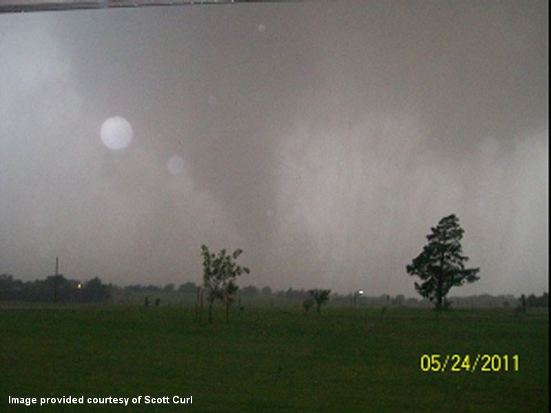 Photo provided courtesy of Scott Curl |
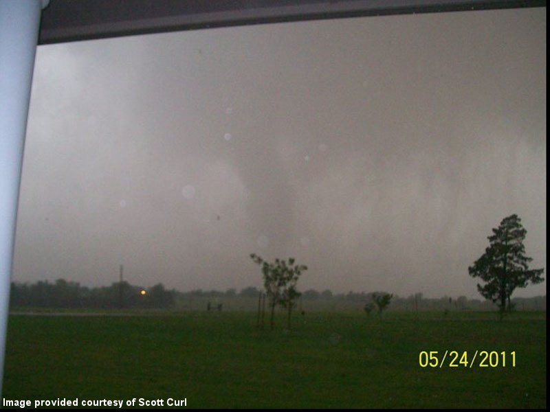 Photo provided courtesy of Scott Curl |
5:18 PM CDT - 5:23 PM CDT - 5:55 PM CDT
WWUS54 KOUN 242218
SVSOUN
SEVERE WEATHER STATEMENT
NATIONAL WEATHER SERVICE NORMAN OK
518 PM CDT TUE MAY 24 2011
OKC017-051-242230-
/O.CON.KOUN.TO.W.0047.000000T0000Z-110524T2230Z/
CANADIAN OK-GRADY OK-
518 PM CDT TUE MAY 24 2011
...A TORNADO WARNING REMAINS IN EFFECT UNTIL 530 PM CDT FOR NORTHERN
GRADY AND EXTREME SOUTHEASTERN CANADIAN COUNTIES...
AT 516 PM CDT...A THUNDERSTORM WITH A HISTORY OF PRODUCING TORNADOES
WAS LOCATED OVER NORTHEAST PARTS OF CHICKASHA...MOVING NORTHEAST AT
40 MPH. THIS STORM WILL LIKELY TRACK ALONG I-44 TOWARD BRIDGE
CREEK AND NEW CASTLE.
* LOCATIONS IN THE WARNING INCLUDE AMBER...BRIDGE CREEK...
CHICKASHA...LAVERTY...MIDDLEBERG...NORGE...POCASSET...SOUTHWESTERN
OKLAHOMA CITY...TABLER AND TUTTLE.
THIS INCLUDES INTERSTATE 44 BETWEEN MILE MARKERS 73 AND 101.
LAT...LON 3494 9801 3497 9809 3499 9809 3534 9786
3538 9768 3509 9767 3490 9802
TIME...MOT...LOC 2216Z 222DEG 33KT 3506 9788
$$
WFUS54 KOUN 242223
TOROUN
OKC027-051-087-242300-
/O.NEW.KOUN.TO.W.0050.110524T2223Z-110524T2300Z/
BULLETIN - EAS ACTIVATION REQUESTED
TORNADO WARNING
NATIONAL WEATHER SERVICE NORMAN OK
523 PM CDT TUE MAY 24 2011
THE NATIONAL WEATHER SERVICE IN NORMAN HAS ISSUED A
* TORNADO WARNING FOR...
NORTHWESTERN CLEVELAND COUNTY IN CENTRAL OKLAHOMA...
NORTHEASTERN GRADY COUNTY IN CENTRAL OKLAHOMA...
NORTHWESTERN MCCLAIN COUNTY IN CENTRAL OKLAHOMA...
* UNTIL 600 PM CDT
* AT 522 PM CDT...A SEVERE THUNDERSTORM WITH A LARGE TORNADO WAS
MOVING NORTHEAST AT 40 MPH. THIS STORM IS TRAVELING TOWARD
BRIDGE CREEK...NEW CASTLE...MOORE. THIS IS A VERY DANGEROUS
TORNADO.
* LOCATIONS IN THE WARNING INCLUDE AMBER...BLANCHARD...BRIDGE
CREEK...MIDDLEBERG...MOORE...NEWCASTLE...NORTHWESTERN NORMAN...
SOUTHERN OKLAHOMA CITY...STANLEY DRAPER LAKE AND TABLER.
THIS INCLUDES INTERSTATE 35 BETWEEN MILE MARKERS 110 AND 120.
THIS INCLUDES INTERSTATE 44 BETWEEN MILE MARKERS 85 AND 114.
PRECAUTIONARY/PREPAREDNESS ACTIONS...
TAKE COVER NOW. LEAVE MOBILE HOMES AND VEHICLES. IF POSSIBLE...MOVE
TO A BASEMENT OR STORM SHELTER. OTHERWISE MOVE TO AN INTERIOR ROOM OR
HALLWAY ON THE LOWEST FLOOR. STAY AWAY FROM WINDOWS AND OUTSIDE
WALLS.
&&
LAT...LON 3499 9787 3520 9792 3534 9771 3534 9767
3537 9767 3538 9765 3538 9722
TIME...MOT...LOC 2222Z 231DEG 33KT 3509 9783
$$
WFUS54 KOUN 242255
TOROUN
OKC027-087-109-242345-
/O.NEW.KOUN.TO.W.0055.110524T2255Z-110524T2345Z/
BULLETIN - EAS ACTIVATION REQUESTED
TORNADO WARNING
NATIONAL WEATHER SERVICE NORMAN OK
555 PM CDT TUE MAY 24 2011
THE NATIONAL WEATHER SERVICE IN NORMAN HAS ISSUED A
* TORNADO WARNING FOR...
NORTHWESTERN CLEVELAND COUNTY IN CENTRAL OKLAHOMA...
NORTHWESTERN MCCLAIN COUNTY IN CENTRAL OKLAHOMA...
OKLAHOMA COUNTY IN CENTRAL OKLAHOMA...
* UNTIL 645 PM CDT
* AT 555 PM CDT...A LARGE... VIOLENT TORNADO WAS LOCATED 4 MILES
NORTHEAST OF NEWCASTLE...MOVING NORTHEAST AT 40 MPH.
* LOCATIONS IN THE WARNING INCLUDE ARCADIA...CHOCTAW...DEL CITY...
EASTERN EDMOND...EASTERN OKLAHOMA CITY...FOREST PARK...HARRAH...
JONES...LAKE ALUMA...LUTHER...MIDWEST CITY...MOORE...NEWALLA...
NEWCASTLE...NICOMA PARK...NORTHWESTERN NORMAN...SPENCER...STANLEY
DRAPER LAKE...TINKER AIR FORCE BASE AND VALLEY BROOK.
THIS INCLUDES INTERSTATE 35 BETWEEN MILE MARKERS 110 AND 146.
THIS INCLUDES INTERSTATE 40 BETWEEN MILE MARKERS 147 AND 172.
THIS INCLUDES INTERSTATE 44 BETWEEN MILE MARKERS 105 AND 152.
PRECAUTIONARY/PREPAREDNESS ACTIONS...
THIS IS AN EXTREMELY DANGEROUS AND LIFE THREATENING SITUATION. IF YOU
ARE IN THE PATH OF THIS LARGE AND DESTRUCTIVE TORNADO... TAKE COVER
IMMEDIATELY. A BASEMENT OR STORM SHELTER IS BEST. OTHERWISE...TAKE
COVER IN AN INTERIOR CLOSET OR BATHROOM AWAY FROM OUTSIDE WALLS AND
WINDOWS. COVER YOUR HEAD WITH PILLOWS AND BLANKETS.
&&
LAT...LON 3539 9715 3518 9755 3530 9767 3572 9742
3572 9714
TIME...MOT...LOC 2255Z 219DEG 34KT 3532 9755
$$
| Tornado Number |
Date | Time (CST) |
Length of Path (miles) |
Width of Path (yards) |
F-Scale | Killed | Injured | County | Location |
|---|---|---|---|---|---|---|---|---|---|
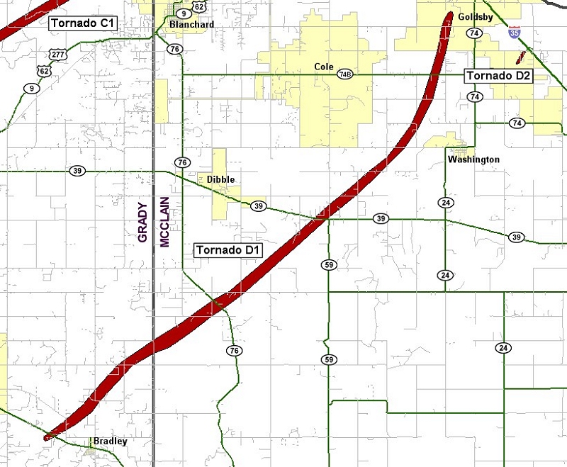
| D1 | 05/24/2011 | 1626-1705 | 23 | 880 | EF4 | 0 | 61 | Grady/ McClain | 2 W Bradley - 1 W Goldsby |
This tornado developed west of Bradley in Grady County, downing tree limbs as it moved northeast. The tornado began to increase in intensity, producing EF-3 damage, as it approached McClain County. Although the damage was confined to trees, the severity of the damage became more intense. Trees were snapped at the bases, or debarked altogether. The tornado was several hundred yards wide as it neared the county line. Luckily, very few structures were in the path.
Widespread tree damage and ground scouring was ongoing as the tornado crossed into McClain County. As the tornado crossed Highway 76, even more intense damage occurred. EF-4 damage was surveyed at several locations. Several homes were reduced to a pile of rubble, or were wiped clean off of their foundations. Automobiles were mangled and almost unrecognizable. The tornado weakened and narrowed as it crossed CR 410. Even though the tornado had weakened, EF-2 to EF-3 damage was still occurring as it approached OK State Highway 39.
The tornado increased in intensity once again near the Highway, with EF-4 damage surveyed for the 2nd time. Well constructed homes were destroyed, with several wiped clean off of their foundations. This also began a longer streak of higher end damage, with EF-3 to EF-4 damage occurring until it crossed OK State Highway 74B, west of High Avenue. Equally devastating destruction occurred over the areas of EF-4 damage. The tornado lifted west of Goldsby with still EF-3 damage occurring prior to lifting. It should be noted that this tornado had estimated winds up to 200 mph at times, falling just short of the damage indicator for an EF-5 tornado. Monetary damage estimates were not available.
| Twin Lakes, OK (KTLX) Radar Relectivity and Storm Relative Velocity | |
|---|---|
 Combination Radar Reflectivity and Storm Relative Velocity at 5:22 PM CDT on 5/24/2011") 5:22 PM CDT |
 Combination Radar Reflectivity and Storm Relative Velocity at 5:26 PM CDT on 5/24/2011") 5:26 PM CDT |
 Combination Radar Reflectivity and Storm Relative Velocity at 5:31 PM CDT on 5/24/2011") 5:31 PM CDT |
 Combination Radar Reflectivity and Storm Relative Velocity at 5:35 PM CDT on 5/24/2011") 5:35 PM CDT |
 Combination Radar Reflectivity and Storm Relative Velocity at 5:39 PM CDT on 5/24/2011") 5:39 PM CDT |
 Combination Radar Reflectivity and Storm Relative Velocity at 5:43 PM CDT on 5/24/2011") 5:43 PM CDT |
 Combination Radar Reflectivity and Storm Relative Velocity at 5:48 PM CDT on 5/24/2011") 5:48 PM CDT |
 Combination Radar Reflectivity and Storm Relative Velocity at 5:52 PM CDT on 5/24/2011") 5:52 PM CDT |
 Combination Radar Reflectivity and Storm Relative Velocity at 5:56 PM CDT on 5/24/2011") 5:56 PM CDT |
 Combination Radar Reflectivity and Storm Relative Velocity at 6:00 PM CDT on 5/24/2011") 6:00 PM CDT |
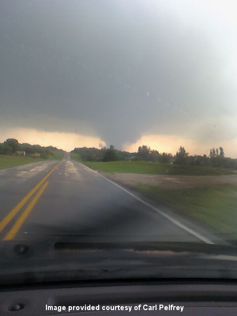 View of Tornado D1 located near Dibble, OK. Photo provided courtesy of Carl Pelfrey. |
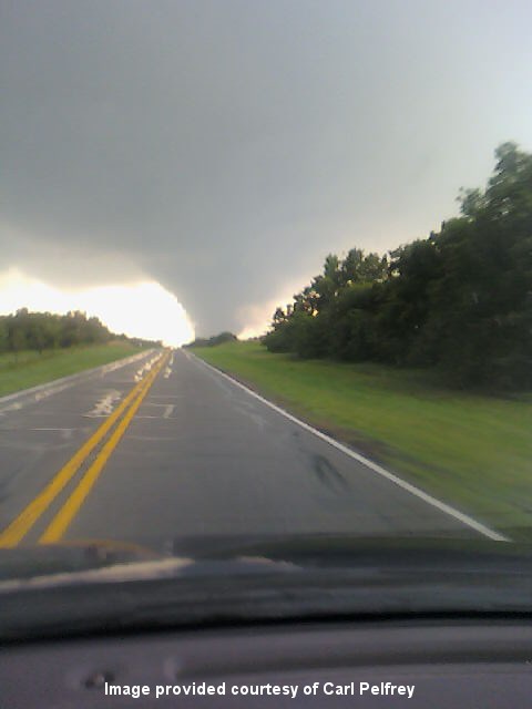 View of Tornado D1 located near Dibble, OK. Photo provided courtesy of Carl Pelfrey. |
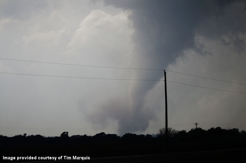 Looking west from I-35 at Tornado D1. Photo provided courtesy of Tim Marquis. |
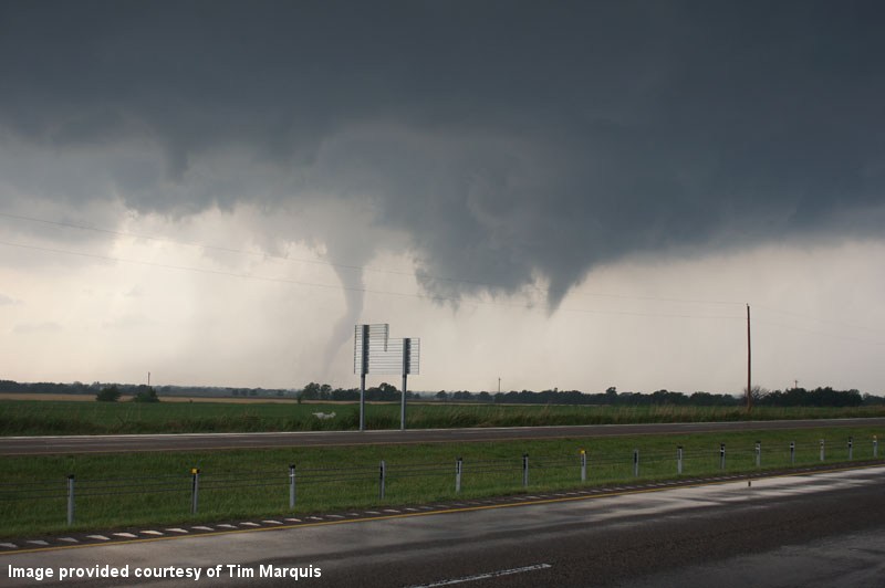 Looking west from I-35 at Tornado D1 to the left and behind Tornado D2. Photo provided courtesy of Tim Marquis. |
View of Tornado D1 located near Goldsby, OK. Photo provided courtesy of Derrick James. |
 |
 |
 |
 |
 |
 |
 |
 |
 |
 |
 |
 |
 |
 |
 |
 |
5:10 PM CDT - 5:30 PM CDT - 5:48 PM CDT - 6:00 PM CDT
WFUS54 KOUN 242210
TOROUN
OKC051-087-242300-
/O.NEW.KOUN.TO.W.0049.110524T2210Z-110524T2300Z/

BULLETIN - EAS ACTIVATION REQUESTED
TORNADO WARNING
NATIONAL WEATHER SERVICE NORMAN OK
510 PM CDT TUE MAY 24 2011

THE NATIONAL WEATHER SERVICE IN NORMAN HAS ISSUED A

* TORNADO WARNING FOR...
  SOUTHERN GRADY COUNTY IN CENTRAL OKLAHOMA...
  WESTERN MCCLAIN COUNTY IN CENTRAL OKLAHOMA...

* UNTIL 600 PM CDT

* AT 510 PM CDT...NATIONAL WEATHER SERVICE RADAR INDICATED A SEVERE
  THUNDERSTORM CAPABLE OF PRODUCING A TORNADO 3 MILES SOUTH OF RUSH
  SPRINGS...MOVING NORTHEAST AT 40 MPH.

* LOCATIONS IN THE WARNING INCLUDE ACME...AGAWAM...ALEX...BRADLEY...
  COLE...CRINER...DIBBLE...GOLDSBY...NINNEKAH...RUSH SPRINGS AND
  WASHINGTON.

THIS INCLUDES INTERSTATE 35 BETWEEN MILE MARKERS 96 AND 107.

PRECAUTIONARY/PREPAREDNESS ACTIONS...

TAKE COVER NOW. LEAVE MOBILE HOMES AND VEHICLES. IF POSSIBLE...MOVE
TO A BASEMENT OR STORM SHELTER. OTHERWISE MOVE TO AN INTERIOR ROOM OR
HALLWAY ON THE LOWEST FLOOR. STAY AWAY FROM WINDOWS AND OUTSIDE
WALLS.

&&

LAT...LON 3520 9751 3504 9738 3469 9797 3486 9809
TIME...MOT...LOC 2210Z 218DEG 35KT 3478 9791

$$
WWUS54 KOUN 242230
SVSOUN
SEVERE WEATHER STATEMENT
NATIONAL WEATHER SERVICE NORMAN OK
530 PM CDT TUE MAY 24 2011
OKC051-087-242300-
/O.CON.KOUN.TO.W.0049.000000T0000Z-110524T2300Z/
GRADY OK-MCCLAIN OK-
530 PM CDT TUE MAY 24 2011
...A TORNADO WARNING REMAINS IN EFFECT UNTIL 600 PM CDT FOR WESTERN
MCCLAIN AND EASTERN GRADY COUNTIES...
AT 530 PM CDT...NATIONAL WEATHER SERVICE RADAR DETECTED A SEVERE
THUNDERSTORM WITH STRONG INDICATIONS OF A TORNADO. THIS
STORM IS 3 MILES WEST OF BRADLEY...MOVING NORTHEAST AT 45 MPH.
* LOCATIONS IN THE WARNING INCLUDE ALEX...BRADLEY...COLE...CRINER...
DIBBLE...GOLDSBY AND WASHINGTON.
THIS INCLUDES INTERSTATE 35 BETWEEN MILE MARKERS 101 AND 106.
LAT...LON 3492 9789 3520 9751 3504 9738 3480 9779
TIME...MOT...LOC 2230Z 228DEG 39KT 3489 9772
$$
WFUS54 KOUN 242248
TOROUN
OKC027-087-242330-
/O.NEW.KOUN.TO.W.0053.110524T2248Z-110524T2330Z/
BULLETIN - EAS ACTIVATION REQUESTED
TORNADO WARNING
NATIONAL WEATHER SERVICE NORMAN OK
548 PM CDT TUE MAY 24 2011
THE NATIONAL WEATHER SERVICE IN NORMAN HAS ISSUED A
* TORNADO WARNING FOR...
CLEVELAND COUNTY IN CENTRAL OKLAHOMA...
CENTRAL MCCLAIN COUNTY IN CENTRAL OKLAHOMA...
* UNTIL 630 PM CDT
* AT 547 PM CDT...NATIONAL WEATHER SERVICE RADAR INDICATED A SEVERE
THUNDERSTORM CAPABLE OF PRODUCING A TORNADO 13 MILES SOUTHWEST
OF GOLDSBY...MOVING NORTHEAST AT 40 MPH. SOUTHERN AND EASTERN
PARTS OF NORMAN ARE MORE AT RISK WITH THIS STORM. WASHINGTON
AND NOBLE ARE ALSO IN THE PATH OF THIS STORM.
* LOCATIONS IN THE WARNING INCLUDE GOLDSBY...LAKE THUNDERBIRD...
NOBLE...NORMAN...SLAUGHTERVILLE...SOUTHEASTERN OKLAHOMA CITY AND
STELLA.
THIS INCLUDES INTERSTATE 35 BETWEEN MILE MARKERS 95 AND 109.
THIS INCLUDES INTERSTATE 40 BETWEEN MILE MARKERS 169 AND 173.
PRECAUTIONARY/PREPAREDNESS ACTIONS...
IN ADDITION TO A TORNADO THREAT... THIS STORM LIKELY CONTAINS
DAMAGING HAIL TO THE SIZE OF BASEBALLS OR LARGER.
&&
LAT...LON 3500 9742 3517 9757 3539 9721 3539 9715
3519 9714 3518 9714
TIME...MOT...LOC 2247Z 218DEG 35KT 3502 9758
$$
WWUS54 KOUN 242300
SVSOUN
SEVERE WEATHER STATEMENT
NATIONAL WEATHER SERVICE NORMAN OK
600 PM CDT TUE MAY 24 2011
OKC027-087-242330-
/O.CON.KOUN.TO.W.0053.000000T0000Z-110524T2330Z/
CLEVELAND OK-MCCLAIN OK-
600 PM CDT TUE MAY 24 2011
...A TORNADO WARNING REMAINS IN EFFECT UNTIL 630 PM CDT FOR CENTRAL
MCCLAIN AND CLEVELAND COUNTIES...
AT 559 PM CDT...A TORNADO WAS MOVING TOWARD NOBLE...AND THE
LAKE THUNDERBIRD AREA. THE STORM IS MOVING NORTHEAST AROUND
40 MPH. THIS IS A DANGEROUS TORNADO SITUATION.
* LOCATIONS IN THE WARNING INCLUDE GOLDSBY...LAKE THUNDERBIRD...
NOBLE...NORMAN...SLAUGHTERVILLE...SOUTHEASTERN OKLAHOMA CITY AND
STELLA.
THIS INCLUDES INTERSTATE 35 BETWEEN MILE MARKERS 95 AND 109.
LAT...LON 3500 9742 3517 9757 3539 9721 3539 9715
3519 9714 3518 9714
TIME...MOT...LOC 2259Z 223DEG 34KT 3510 9748
$$
| Tornado Number |
Date | Time (CST) |
Length of Path (miles) |
Width of Path (yards) |
F-Scale | Killed | Injured | County | Location |
|---|---|---|---|---|---|---|---|---|---|
| D2 | 05/24/2011 | 1702-1703 | 0.5 | 40 | EF1 | 0 | 0 | McClain | 2.5 SE Goldsby |
Storm chasers observed a tornado southeast of Goldsby in a parallel track to the east-southeast of the primary Washington-Goldsby tornado. An NWS storm survey team observed barn damage associated with this tornado.
| Twin Lakes, OK (KTLX) Radar Relectivity and Storm Relative Velocity | |
|---|---|
 Combination Radar Reflectivity and Storm Relative Velocity at 6:05 PM CDT on 5/24/2011") 6:00 PM CDT |
 Combination Radar Reflectivity and Storm Relative Velocity at 6:05 PM CDT on 5/24/2011") 6:05 PM CDT |
Looking west from I-35 at Tornado D1 to the left and behind Tornado D2. Photo provided courtesy of Tim Marquis. |
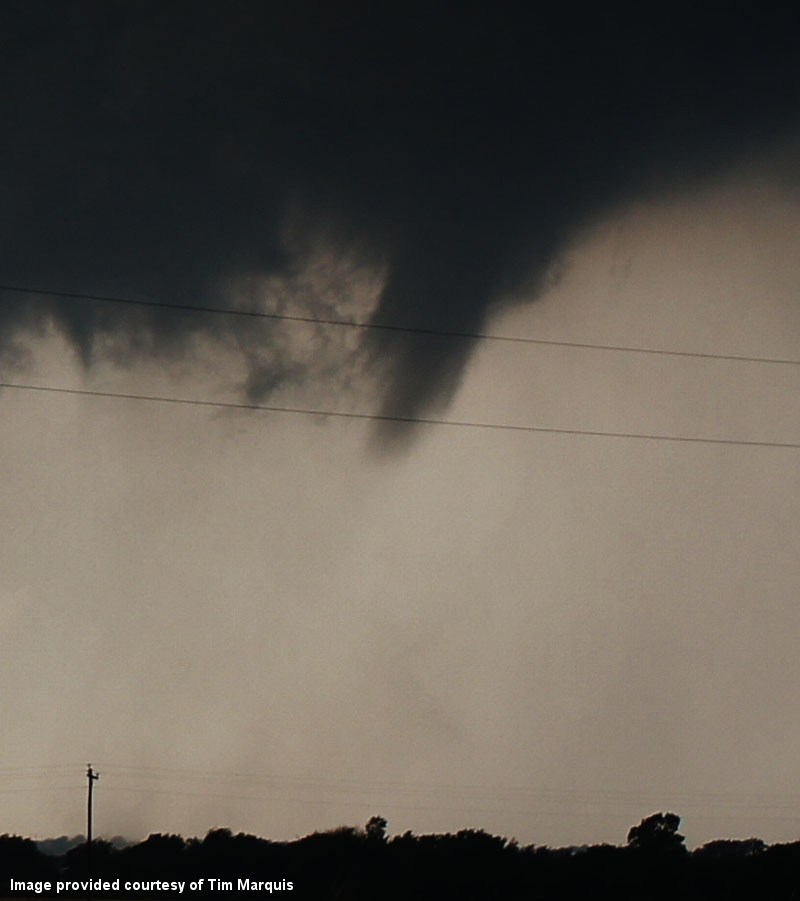 Looking west at a closer view of Tornado D2. Photo provided courtesy of Tim Marquis. |
5:10 PM CDT - 5:30 PM CDT - 5:48 PM CDT - 6:00 PM CDT
WFUS54 KOUN 242210
TOROUN
OKC051-087-242300-
/O.NEW.KOUN.TO.W.0049.110524T2210Z-110524T2300Z/

BULLETIN - EAS ACTIVATION REQUESTED
TORNADO WARNING
NATIONAL WEATHER SERVICE NORMAN OK
510 PM CDT TUE MAY 24 2011

THE NATIONAL WEATHER SERVICE IN NORMAN HAS ISSUED A

* TORNADO WARNING FOR...
  SOUTHERN GRADY COUNTY IN CENTRAL OKLAHOMA...
  WESTERN MCCLAIN COUNTY IN CENTRAL OKLAHOMA...

* UNTIL 600 PM CDT

* AT 510 PM CDT...NATIONAL WEATHER SERVICE RADAR INDICATED A SEVERE
  THUNDERSTORM CAPABLE OF PRODUCING A TORNADO 3 MILES SOUTH OF RUSH
  SPRINGS...MOVING NORTHEAST AT 40 MPH.

* LOCATIONS IN THE WARNING INCLUDE ACME...AGAWAM...ALEX...BRADLEY...
  COLE...CRINER...DIBBLE...GOLDSBY...NINNEKAH...RUSH SPRINGS AND
  WASHINGTON.

THIS INCLUDES INTERSTATE 35 BETWEEN MILE MARKERS 96 AND 107.

PRECAUTIONARY/PREPAREDNESS ACTIONS...

TAKE COVER NOW. LEAVE MOBILE HOMES AND VEHICLES. IF POSSIBLE...MOVE
TO A BASEMENT OR STORM SHELTER. OTHERWISE MOVE TO AN INTERIOR ROOM OR
HALLWAY ON THE LOWEST FLOOR. STAY AWAY FROM WINDOWS AND OUTSIDE
WALLS.

&&

LAT...LON 3520 9751 3504 9738 3469 9797 3486 9809
TIME...MOT...LOC 2210Z 218DEG 35KT 3478 9791

$$
WWUS54 KOUN 242230
SVSOUN
SEVERE WEATHER STATEMENT
NATIONAL WEATHER SERVICE NORMAN OK
530 PM CDT TUE MAY 24 2011
OKC051-087-242300-
/O.CON.KOUN.TO.W.0049.000000T0000Z-110524T2300Z/
GRADY OK-MCCLAIN OK-
530 PM CDT TUE MAY 24 2011
...A TORNADO WARNING REMAINS IN EFFECT UNTIL 600 PM CDT FOR WESTERN
MCCLAIN AND EASTERN GRADY COUNTIES...
AT 530 PM CDT...NATIONAL WEATHER SERVICE RADAR DETECTED A SEVERE
THUNDERSTORM WITH STRONG INDICATIONS OF A TORNADO. THIS
STORM IS 3 MILES WEST OF BRADLEY...MOVING NORTHEAST AT 45 MPH.
* LOCATIONS IN THE WARNING INCLUDE ALEX...BRADLEY...COLE...CRINER...
DIBBLE...GOLDSBY AND WASHINGTON.
THIS INCLUDES INTERSTATE 35 BETWEEN MILE MARKERS 101 AND 106.
LAT...LON 3492 9789 3520 9751 3504 9738 3480 9779
TIME...MOT...LOC 2230Z 228DEG 39KT 3489 9772
$$
WFUS54 KOUN 242248
TOROUN
OKC027-087-242330-
/O.NEW.KOUN.TO.W.0053.110524T2248Z-110524T2330Z/
BULLETIN - EAS ACTIVATION REQUESTED
TORNADO WARNING
NATIONAL WEATHER SERVICE NORMAN OK
548 PM CDT TUE MAY 24 2011
THE NATIONAL WEATHER SERVICE IN NORMAN HAS ISSUED A
* TORNADO WARNING FOR...
CLEVELAND COUNTY IN CENTRAL OKLAHOMA...
CENTRAL MCCLAIN COUNTY IN CENTRAL OKLAHOMA...
* UNTIL 630 PM CDT
* AT 547 PM CDT...NATIONAL WEATHER SERVICE RADAR INDICATED A SEVERE
THUNDERSTORM CAPABLE OF PRODUCING A TORNADO 13 MILES SOUTHWEST
OF GOLDSBY...MOVING NORTHEAST AT 40 MPH. SOUTHERN AND EASTERN
PARTS OF NORMAN ARE MORE AT RISK WITH THIS STORM. WASHINGTON
AND NOBLE ARE ALSO IN THE PATH OF THIS STORM.
* LOCATIONS IN THE WARNING INCLUDE GOLDSBY...LAKE THUNDERBIRD...
NOBLE...NORMAN...SLAUGHTERVILLE...SOUTHEASTERN OKLAHOMA CITY AND
STELLA.
THIS INCLUDES INTERSTATE 35 BETWEEN MILE MARKERS 95 AND 109.
THIS INCLUDES INTERSTATE 40 BETWEEN MILE MARKERS 169 AND 173.
PRECAUTIONARY/PREPAREDNESS ACTIONS...
IN ADDITION TO A TORNADO THREAT... THIS STORM LIKELY CONTAINS
DAMAGING HAIL TO THE SIZE OF BASEBALLS OR LARGER.
&&
LAT...LON 3500 9742 3517 9757 3539 9721 3539 9715
3519 9714 3518 9714
TIME...MOT...LOC 2247Z 218DEG 35KT 3502 9758
$$
WWUS54 KOUN 242300
SVSOUN
SEVERE WEATHER STATEMENT
NATIONAL WEATHER SERVICE NORMAN OK
600 PM CDT TUE MAY 24 2011
OKC027-087-242330-
/O.CON.KOUN.TO.W.0053.000000T0000Z-110524T2330Z/
CLEVELAND OK-MCCLAIN OK-
600 PM CDT TUE MAY 24 2011
...A TORNADO WARNING REMAINS IN EFFECT UNTIL 630 PM CDT FOR CENTRAL
MCCLAIN AND CLEVELAND COUNTIES...
AT 559 PM CDT...A TORNADO WAS MOVING TOWARD NOBLE...AND THE
LAKE THUNDERBIRD AREA. THE STORM IS MOVING NORTHEAST AROUND
40 MPH. THIS IS A DANGEROUS TORNADO SITUATION.
* LOCATIONS IN THE WARNING INCLUDE GOLDSBY...LAKE THUNDERBIRD...
NOBLE...NORMAN...SLAUGHTERVILLE...SOUTHEASTERN OKLAHOMA CITY AND
STELLA.
THIS INCLUDES INTERSTATE 35 BETWEEN MILE MARKERS 95 AND 109.
LAT...LON 3500 9742 3517 9757 3539 9721 3539 9715
3519 9714 3518 9714
TIME...MOT...LOC 2259Z 223DEG 34KT 3510 9748
$$
| Tornado Number |
Date | Time (CST) |
Length of Path (miles) |
Width of Path (yards) |
F-Scale | Killed | Injured | County | Location |
|---|---|---|---|---|---|---|---|---|---|
| D3 | 05/24/2011 | 1736-1739 | 2 | 50 | EF2 | 0 | 1 | Pottawatomie | 4.5 SSW - 3.5 S McLoud |
This tornado developed west-southwest of the intersection of Fishmarket Road and Memorial Road to the south-southwest of McLoud. The tornado moved east-northeast where a telephone company building lost its roof, and a number of sheds were damaged and causing tree damage as it crossed the intersection and Fishmarket and Memorial Roads. Extensive tree damage continued northeast of this intersection, at least one home suffered the destruction of an attached garage and a few homes suffered roof and window damage. The tornado turned north-northeast crossing U.S. Interstate 40 near the Walker Road bridge where it struck and semi truck, lifting and destroying the trailer, lofting the pieces to the north, and injuring the truck driver. The tornado dissipated soon after crossing Interstate 40. Although the tornado was very narrow, the rotational velocity of the tornado was observed to be very strong. Monetary damage estimates were not available.
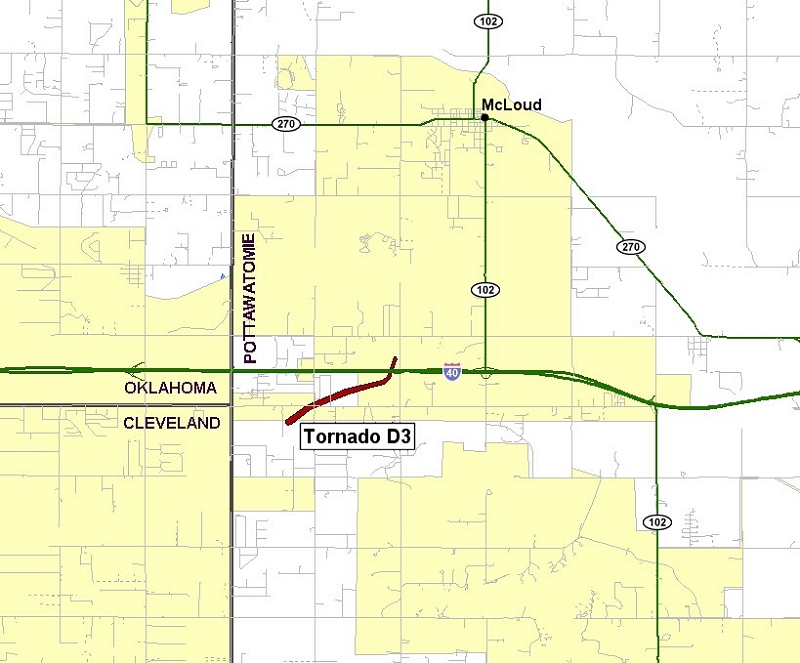
| Twin Lakes, OK (KTLX) Radar Relectivity and Storm Relative Velocity | |
|---|---|
 Combination Radar Reflectivity and Storm Relative Velocity at 6:30 PM CDT on 5/24/2011") 6:30 PM CDT |
 Combination Radar Reflectivity and Storm Relative Velocity at 6:34 PM CDT on 5/24/2011") 6:34 PM CDT |
 Combination Radar Reflectivity and Storm Relative Velocity at 6:39 PM CDT on 5/24/2011") 6:39 PM CDT |
 Combination Radar Reflectivity and Storm Relative Velocity at 6:43 PM CDT on 5/24/2011") 6:43 PM CDT |
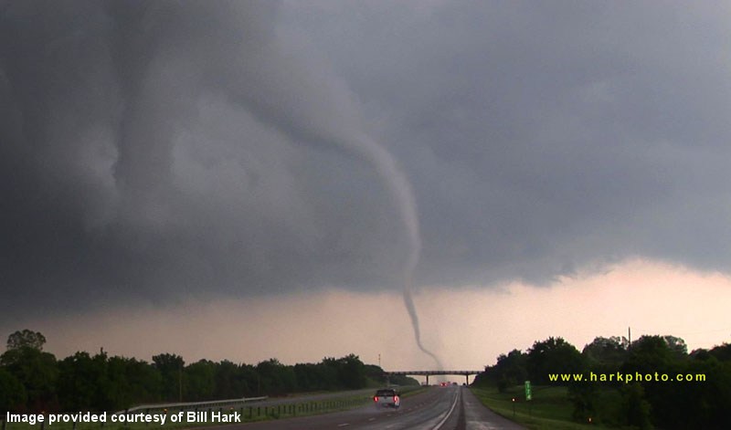 |
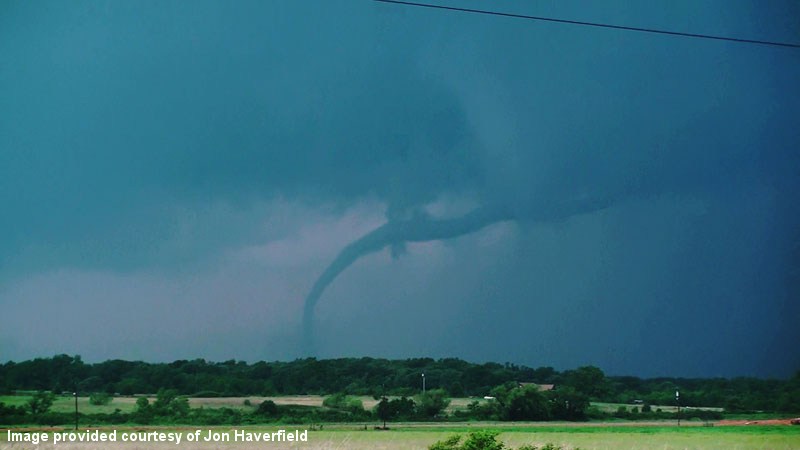 |
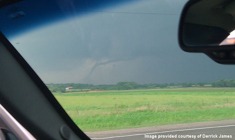 |
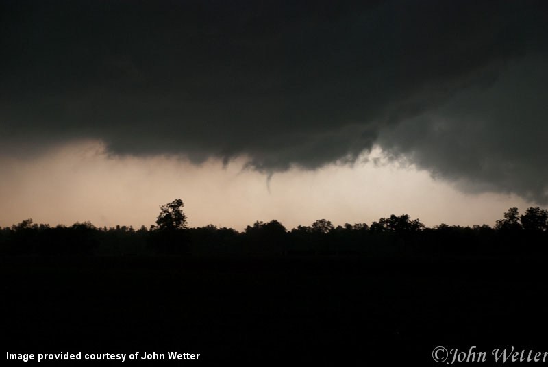 |
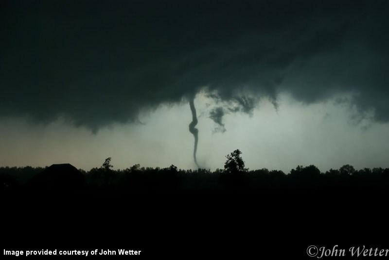 |
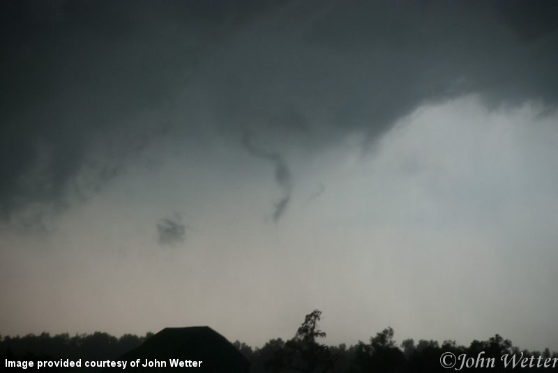 |
 |
 |
 |
 |
 |
 |
 |
 |
6:21 PM CDT - 6:45 PM CDT - 7:13 PM CDT
WFUS54 KOUN 242321
TOROUN
OKC027-081-109-125-250015-
/O.NEW.KOUN.TO.W.0057.110524T2321Z-110525T0015Z/

BULLETIN - EAS ACTIVATION REQUESTED
TORNADO WARNING
NATIONAL WEATHER SERVICE NORMAN OK
621 PM CDT TUE MAY 24 2011

THE NATIONAL WEATHER SERVICE IN NORMAN HAS ISSUED A

* TORNADO WARNING FOR...
  NORTHEASTERN CLEVELAND COUNTY IN CENTRAL OKLAHOMA...
  SOUTHEASTERN LINCOLN COUNTY IN CENTRAL OKLAHOMA...
  SOUTHEASTERN OKLAHOMA COUNTY IN CENTRAL OKLAHOMA...
  NORTHERN POTTAWATOMIE COUNTY IN CENTRAL OKLAHOMA...

* UNTIL 715 PM CDT

* AT 621 PM CDT...A THUNDERSTORM WITH A HISTORY OF PRODUCING
TORNADOES WAS LOCATED OVER EASTERN NORMAN...JUST NORTHWEST OF LAKE
THUNDERBIRD...MOVING NORTHEAST AT 50 MPH.

* LOCATIONS IN THE WARNING INCLUDE AVERY...AYDELOTTE...BETHEL
  ACRES...CHANDLER...DALE...DAVENPORT...JOHNSON...KENDRICK...LAKE
  THUNDERBIRD...MCLOUD...MEEKER...NEWALLA...NORTHEASTERN NORMAN...
  PINK...PRAGUE...SHAWNEE...SOUTHEASTERN OKLAHOMA CITY...SPARKS...
  STELLA AND STROUD.

THIS INCLUDES INTERSTATE 40 BETWEEN MILE MARKERS 167 AND 192.

THIS INCLUDES INTERSTATE 44 BETWEEN MILE MARKERS 164 AND 182.

PRECAUTIONARY/PREPAREDNESS ACTIONS...

TAKE COVER NOW. LEAVE MOBILE HOMES AND VEHICLES. IF POSSIBLE...MOVE
TO A BASEMENT OR STORM SHELTER. OTHERWISE MOVE TO AN INTERIOR ROOM OR
HALLWAY ON THE LOWEST FLOOR. STAY AWAY FROM WINDOWS AND OUTSIDE
WALLS.

&&

LAT...LON 3541 9677 3541 9678 3540 9678 3517 9725
      3528 9736 3590 9675 3574 9661 3549 9661
TIME...MOT...LOC 2321Z 227DEG 44KT 3528 9722

$$
WWUS54 KOUN 242345
SVSOUN
SEVERE WEATHER STATEMENT
NATIONAL WEATHER SERVICE NORMAN OK
645 PM CDT TUE MAY 24 2011
OKC027-109-242355-
/O.CAN.KOUN.TO.W.0057.000000T0000Z-110525T0015Z/
OKLAHOMA OK-CLEVELAND OK-
645 PM CDT TUE MAY 24 2011
...THE TORNADO WARNING HAS BEEN CANCELLED FOR NORTHEASTERN CLEVELAND
AND SOUTHEASTERN OKLAHOMA COUNTIES...
THE TORNADO THREAT HAS MOVED EAST OF OKLAHOMA AND CLEVELAND COUNTIES.
LAT...LON 3541 9678 3540 9679 3537 9709 3550 9714
3590 9675 3574 9661 3549 9661
TIME...MOT...LOC 2345Z 226DEG 39KT 3544 9702
$$
OKC081-125-250015-
/O.CON.KOUN.TO.W.0057.000000T0000Z-110525T0015Z/
LINCOLN OK-POTTAWATOMIE OK-
645 PM CDT TUE MAY 24 2011
...A TORNADO WARNING REMAINS IN EFFECT UNTIL 715 PM CDT FOR NORTHERN
POTTAWATOMIE AND SOUTHEASTERN LINCOLN COUNTIES...
AT 645 PM CDT...A THUNDERSTORM WITH A HISTORY OF PRODUCING TORNADOES
WAS LOCATED 3 MILES NORTH OF DALE...MOVING NORTHEAST AT 45 MPH.
* LOCATIONS IN THE WARNING INCLUDE AVERY...AYDELOTTE...CHANDLER...
DALE...DAVENPORT...JOHNSON...KENDRICK...MCLOUD...MEEKER...PRAGUE...
SPARKS AND STROUD.
THIS INCLUDES INTERSTATE 40 BETWEEN MILE MARKERS 176 AND 184.
THIS INCLUDES INTERSTATE 44 BETWEEN MILE MARKERS 164 AND 182.
PRECAUTIONARY/PREPAREDNESS ACTIONS...
TAKE COVER NOW. LEAVE MOBILE HOMES AND VEHICLES. IF POSSIBLE...MOVE
TO A BASEMENT OR STORM SHELTER. OTHERWISE MOVE TO AN INTERIOR ROOM OR
HALLWAY ON THE LOWEST FLOOR. STAY AWAY FROM WINDOWS AND OUTSIDE
WALLS.
&&
LAT...LON 3541 9678 3540 9679 3537 9709 3550 9714
3590 9675 3574 9661 3549 9661
TIME...MOT...LOC 2345Z 226DEG 39KT 3544 9702
$$
WWUS54 KOUN 250013
SVSOUN
SEVERE WEATHER STATEMENT
NATIONAL WEATHER SERVICE NORMAN OK
713 PM CDT TUE MAY 24 2011
OKC081-125-250022-
/O.EXP.KOUN.TO.W.0057.000000T0000Z-110525T0015Z/
LINCOLN OK-POTTAWATOMIE OK-
713 PM CDT TUE MAY 24 2011
...THE TORNADO WARNING FOR NORTHERN POTTAWATOMIE AND SOUTHEASTERN
LINCOLN COUNTIES WILL EXPIRE AT 715 PM CDT...
THE TORNADIC PORTION OF THE STORM HAS MOVED OUT OF THE AREA. LARGE
HAIL AND DAMAGING WIND GUSTS MAY STILL OCCUR AROUND PRAGUE AND UP
AROUND CHANDLER AND STROUD.
LAT...LON 3541 9678 3540 9679 3537 9709 3550 9714
3590 9675 3574 9661 3549 9661
TIME...MOT...LOC 0012Z 226DEG 39KT 3564 9676
$$
| Tornado Number |
Date | Time (CST) |
Length of Path (miles) |
Width of Path (yards) |
F-Scale | Killed | Injured | County | Location |
|---|---|---|---|---|---|---|---|---|---|
| E1 | 05/24/2011 | 1830-1845 | 6 | 1200 | EF1 | 0 | 0 | Johnston | 1 NW Ravia - 2 N Tishomingo |
This tornado began just north of Ravia and traveled east-northeast toward Tishomingo. Widespread tree damage occurred as, luckily, few structures were in the path. Four homes sustained minor roof damage, with another two homes damage by the falling trees. A 50-foot grain silo also lost its roof. The tornado lifted a couple of miles north of Tishomingo. No injuries were reported as a result of the tornado. Monetary damage estimates were not available.
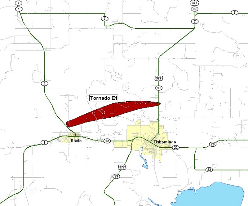
| Twin Lakes, OK (KTLX) Radar Relectivity and Storm Relative Velocity | |
|---|---|
 Radar Reflectivity and Storm Relative Velocity at 7:21 PM CDT on 5/24/2011") 7:21 PM CDT |
 Radar Reflectivity and Storm Relative Velocity at 7:25 PM CDT on 5/24/2011") 7:25 PM CDT |
 Radar Reflectivity and Storm Relative Velocity at 7:29 PM CDT on 5/24/2011") 7:29 PM CDT |
 Radar Reflectivity and Storm Relative Velocity at 7:33 PM CDT on 5/24/2011") 7:33 PM CDT |
 Radar Reflectivity and Storm Relative Velocity at 7:37 PM CDT on 5/24/2011") 7:37 PM CDT |
 Radar Reflectivity and Storm Relative Velocity at 7:41 PM CDT on 5/24/2011") 7:41 PM CDT |
 Radar Reflectivity and Storm Relative Velocity at 7:45 PM CDT on 5/24/2011") 7:45 PM CDT |
 Radar Reflectivity and Storm Relative Velocity at 7:49 PM CDT on 5/24/2011") 7:49 PM CDT |
| Fort Worth, TX (KFWS) Radar Relectivity and Storm Relative Velocity | |
 Radar Reflectivity and Storm Relative Velocity at 7:18 PM CDT on 5/24/2011") 7:18 PM CDT |
 Radar Reflectivity and Storm Relative Velocity at 7:22 PM CDT on 5/24/2011") 7:22 PM CDT |
 Radar Reflectivity and Storm Relative Velocity at 7:26 PM CDT on 5/24/2011") 7:26 PM CDT |
 Radar Reflectivity and Storm Relative Velocity at 7:30 PM CDT on 5/24/2011") 7:30 PM CDT |
 Radar Reflectivity and Storm Relative Velocity at 7:34 PM CDT on 5/24/2011") 7:34 PM CDT |
 Radar Reflectivity and Storm Relative Velocity at 7:39 PM CDT on 5/24/2011") 7:39 PM CDT |
 Radar Reflectivity and Storm Relative Velocity at 7:43 PM CDT on 5/24/2011") 7:43 PM CDT |
 Radar Reflectivity and Storm Relative Velocity at 7:47 PM CDT on 5/24/2011") 7:47 PM CDT |
 Radar Reflectivity and Storm Relative Velocity at 7:51 PM CDT on 5/24/2011") 7:51 PM CDT |
|
6:32 PM CDT - 6:51 PM CDT - 7:33 PM CDT
WFUS54 KOUN 242332
TOROUN
OKC019-069-085-095-250000-
/O.NEW.KOUN.TO.W.0058.110524T2332Z-110525T0000Z/

BULLETIN - EAS ACTIVATION REQUESTED
TORNADO WARNING
NATIONAL WEATHER SERVICE NORMAN OK
632 PM CDT TUE MAY 24 2011

THE NATIONAL WEATHER SERVICE IN NORMAN HAS ISSUED A

* TORNADO WARNING FOR...
  SOUTHWESTERN JOHNSTON COUNTY IN SOUTHEAST OKLAHOMA...
  NORTHWESTERN MARSHALL COUNTY IN SOUTHEAST OKLAHOMA...
  SOUTHEASTERN CARTER COUNTY IN SOUTHERN OKLAHOMA...
  NORTHEASTERN LOVE COUNTY IN SOUTHERN OKLAHOMA...

* UNTIL 700 PM CDT

* AT 631 PM CDT...NATIONAL WEATHER SERVICE RADAR INDICATED A
SEVERE   THUNDERSTORM CAPABLE OF PRODUCING A TORNADO NEAR LAKE
MURRAY...MOVING NORTHEAST AT 55 MPH.

* LOCATIONS IN THE WARNING INCLUDE DICKSON...EXTREME WESTERN LAKE
  TEXOMA...LAKE MURRAY...MANNSVILLE AND OVERBROOK.

THIS INCLUDES INTERSTATE 35 BETWEEN MILE MARKERS 20 AND 26.

PRECAUTIONARY/PREPAREDNESS ACTIONS...

TAKE COVER NOW. LEAVE MOBILE HOMES AND VEHICLES. IF POSSIBLE...MOVE
TO A BASEMENT OR STORM SHELTER. OTHERWISE MOVE TO AN INTERIOR ROOM OR
HALLWAY ON THE LOWEST FLOOR. STAY AWAY FROM WINDOWS AND OUTSIDE
WALLS.

&&

LAT...LON 3433 9696 3426 9684 3424 9678 3393 9700
      3404 9719
TIME...MOT...LOC 2331Z 214DEG 50KT 3405 9701

$$
|
The following are severe weather reports received and issued as local storm reports (LSRs) by the NWS Norman staff for the May 24, 2011 tornado outbreak.
PRELIMINARY LOCAL STORM REPORT...SUMMARY
NATIONAL WEATHER SERVICE NORMAN OK
1015 AM CDT WED MAY 25 2011

..TIME...   ...EVENT...      ...CITY LOCATION...     ...LAT.LON...
..DATE...   ....MAG....      ..COUNTY LOCATION..ST.. ...SOURCE....
            ..REMARKS..

0229 PM     HAIL             HOBART                  35.03N 99.09W
05/24/2011  E1.25 INCH       KIOWA              OK   AMATEUR RADIO

0230 PM     HAIL             HOBART                  35.03N 99.09W
05/24/2011  E1.75 INCH       KIOWA              OK   PUBLIC

0329 PM     HAIL             2 WSW EAKLY             35.30N 98.59W
05/24/2011  E1.75 INCH       CADDO              OK   TRAINED SPOTTER

0333 PM     HAIL             5 ESE FAY               35.79N 98.57W
05/24/2011  E3.00 INCH       BLAINE             OK   TRAINED SPOTTER

0416 PM     HAIL             LAWTON                  34.60N 98.42W
05/24/2011  E1.75 INCH       COMANCHE           OK   BROADCAST MEDIA

            WEST LAWTON

0418 PM     HAIL             WICHITA FALLS           33.91N 98.50W
05/24/2011  E1.00 INCH       WICHITA            TX   TRAINED SPOTTER

            LOOP 11 ANS US 287

0431 PM     HAIL             1 NE LAKE ELLSWORTH     34.84N 98.34W
05/24/2011  E1.75 INCH       COMANCHE           OK   FIRE DEPT/RESCUE

0443 PM     HAIL             MIDWEST CITY            35.46N 97.39W
05/24/2011  E1.75 INCH       OKLAHOMA           OK   AMATEUR RADIO

0502 PM     TSTM WND GST     2 NW PONCA CITY         36.72N 97.11W
05/24/2011  M61.00 MPH       KAY                OK   ASOS

0530 PM     TSTM WND GST     4 WSW GUTHRIE           35.86N 97.49W
05/24/2011  M59.00 MPH       LOGAN              OK   ASOS

0530 PM     TSTM WND GST     8 E NEWKIRK             36.88N 96.91W
05/24/2011  M58.00 MPH       KAY                OK   MESONET

0537 PM     HAIL             2 SW NEWCASTLE          35.23N 97.62W
05/24/2011  E2.75 INCH       MCCLAIN            OK   NWS EMPLOYEE

0550 PM     HAIL             3 N WASHINGTON          35.10N 97.48W
05/24/2011  E2.50 INCH       MCCLAIN            OK   NWS EMPLOYEE

0550 PM     HAIL             1 N NORMAN              35.23N 97.44W
05/24/2011  M1.50 INCH       CLEVELAND          OK   NWS EMPLOYEE

0600 PM     HAIL             4 ENE NOBLE             35.16N 97.33W
05/24/2011  E2.00 INCH       CLEVELAND          OK   NWS EMPLOYEE

0605 PM     HAIL             5 SE NORMAN             35.17N 97.38W
05/24/2011  E1.75 INCH       CLEVELAND          OK   NWS EMPLOYEE

            THE HAIL WAS REPORTED AT HWY 9 AND 60TH STREET. GOLF-BALL
            SIZE HAIL WAS ALSO REPORTED AT ROCK CREEK ROAD AND 60TH
            STREET. THE HAIL OCCURRED FROM 605 PM TO 615 PM.

0607 PM     HAIL             NORMAN                  35.22N 97.44W
05/24/2011  M1.75 INCH       CLEVELAND          OK   NWS EMPLOYEE

            NATIONAL WEATHER CENTER

0614 PM     HAIL             DEL CITY                35.45N 97.44W
05/24/2011  E1.00 INCH       OKLAHOMA           OK   EMERGENCY MNGR

0623 PM     HAIL             TINKER AIR FORCE BASE   35.42N 97.39W
05/24/2011  E1.50 INCH       OKLAHOMA           OK   PUBLIC

0631 PM     TSTM WND GST     TINKER AIR FORCE BASE   35.42N 97.39W
05/24/2011  M69.00 MPH       OKLAHOMA           OK   ASOS

0635 PM     HAIL             HEALDTON                34.23N 97.49W
05/24/2011  E1.00 INCH       CARTER             OK   FIRE DEPT/RESCUE

0700 PM     TSTM WND GST     3 W MARLOW              34.64N 98.01W
05/24/2011  M69.00 MPH       STEPHENS           OK   AMATEUR RADIO

0701 PM     HAIL             1 SE HEALDTON           34.22N 97.47W
05/24/2011  E1.00 INCH       CARTER             OK   AMATEUR RADIO

0708 PM     TSTM WND GST     5 E RUBOTTOM            33.94N 97.37W
05/24/2011  E65.00 MPH       LOVE               OK   PUBLIC

0802 PM     TSTM WND GST     MADILL                  34.09N 96.77W
05/24/2011  E60.00 MPH       MARSHALL           OK   EMERGENCY MNGR

0850 PM     HAIL             ADA                     34.78N 96.66W
05/24/2011  E1.25 INCH       PONTOTOC           OK   PUBLIC

0901 PM     HAIL             ADA                     34.78N 96.66W
05/24/2011  E1.75 INCH       PONTOTOC           OK   PUBLIC


&&

$$

NWS NORMAN
|
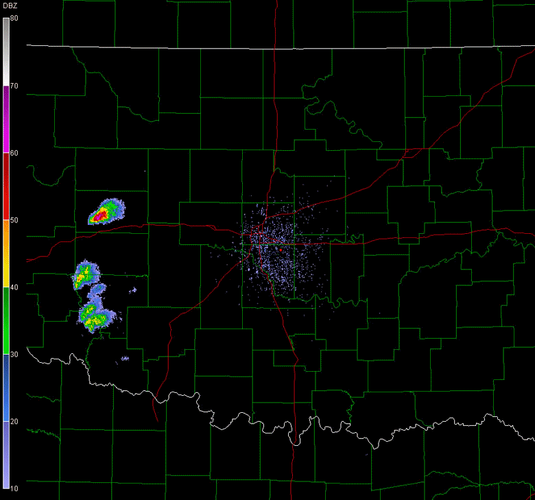
Shown below are several images provided by Scott Bachmeier of the Cooperative Institute for Meteorological Satellite Studies (CIMSS) Satellite Blog. The link to the blog for the May 24, 2011 tornado outbreak is available here.


 |


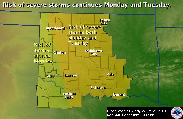
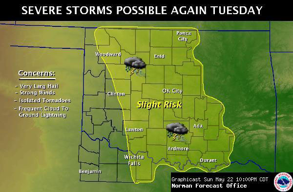
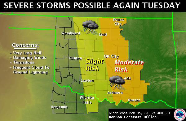
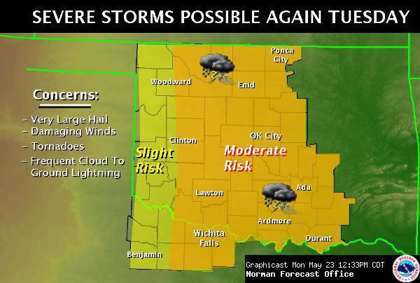
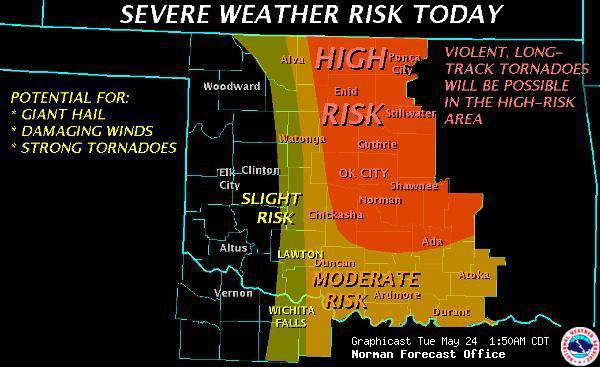
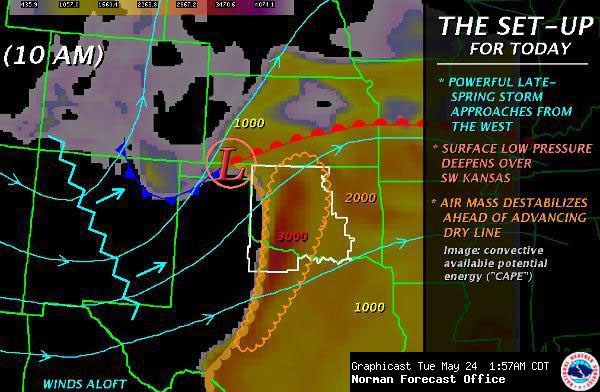
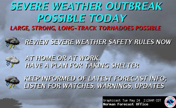
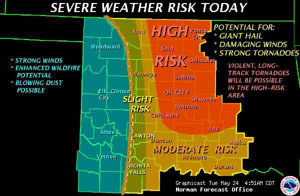
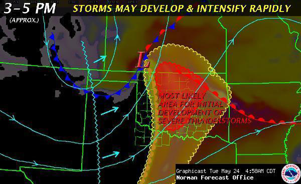
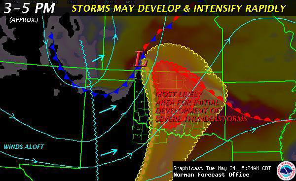
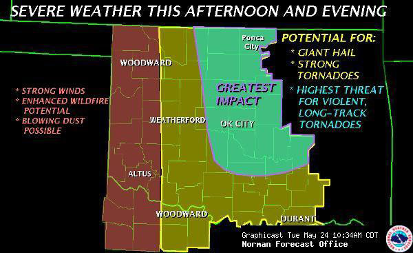
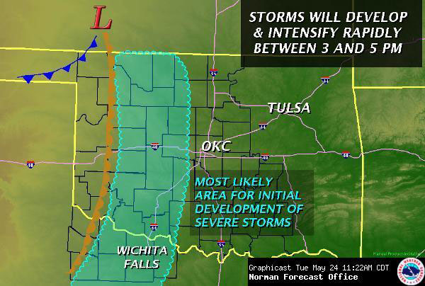
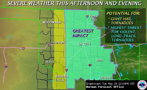

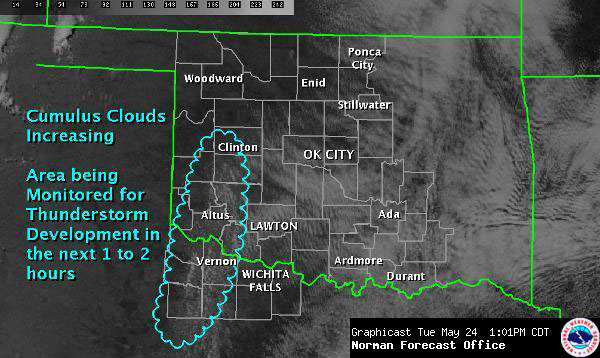
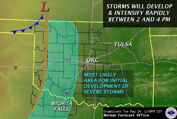

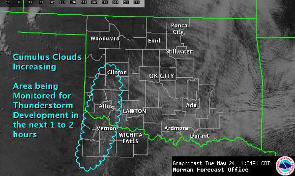
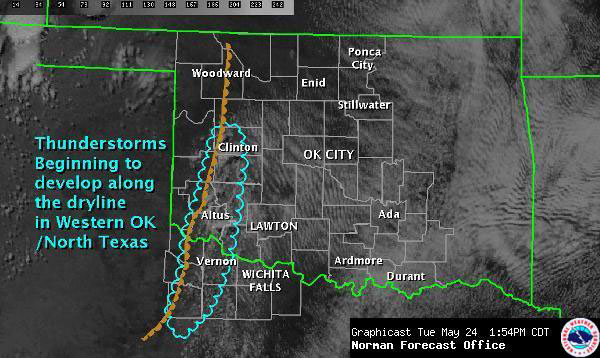
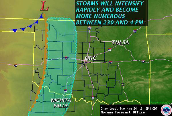
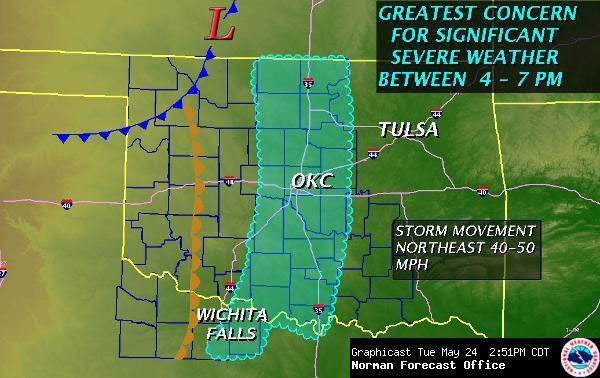
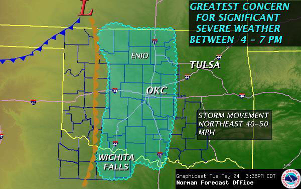
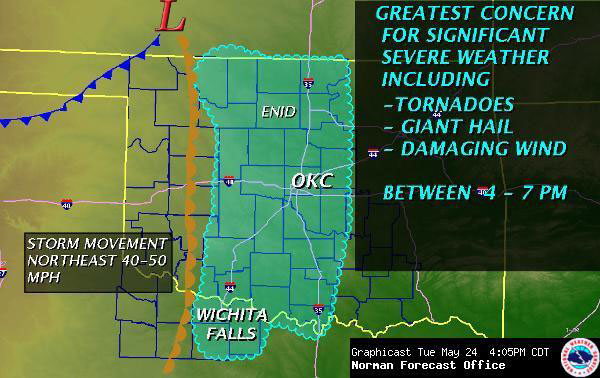
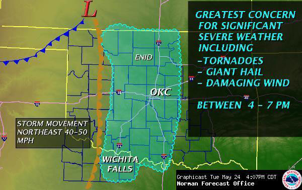
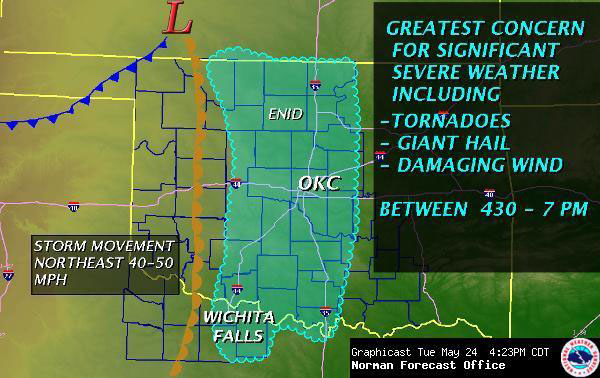
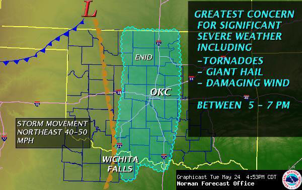
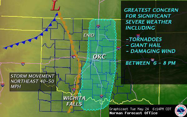
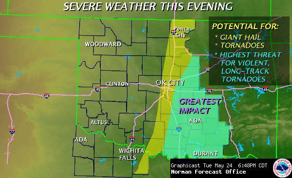
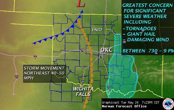
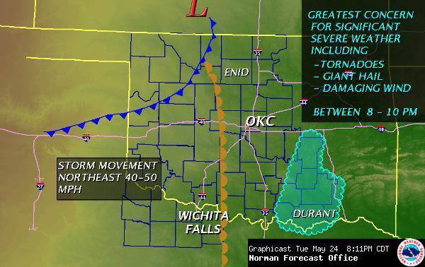
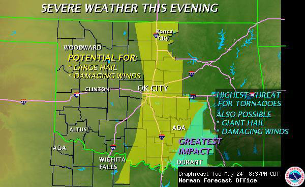
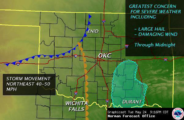
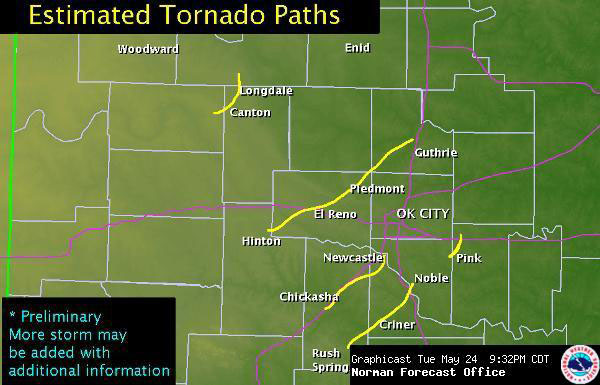
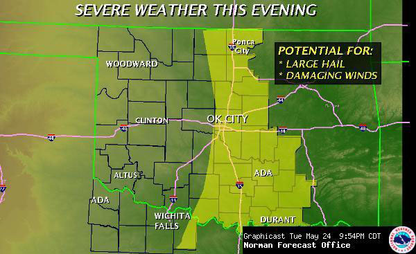
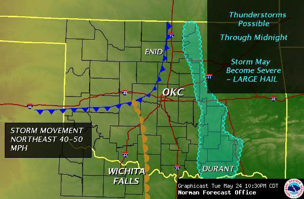
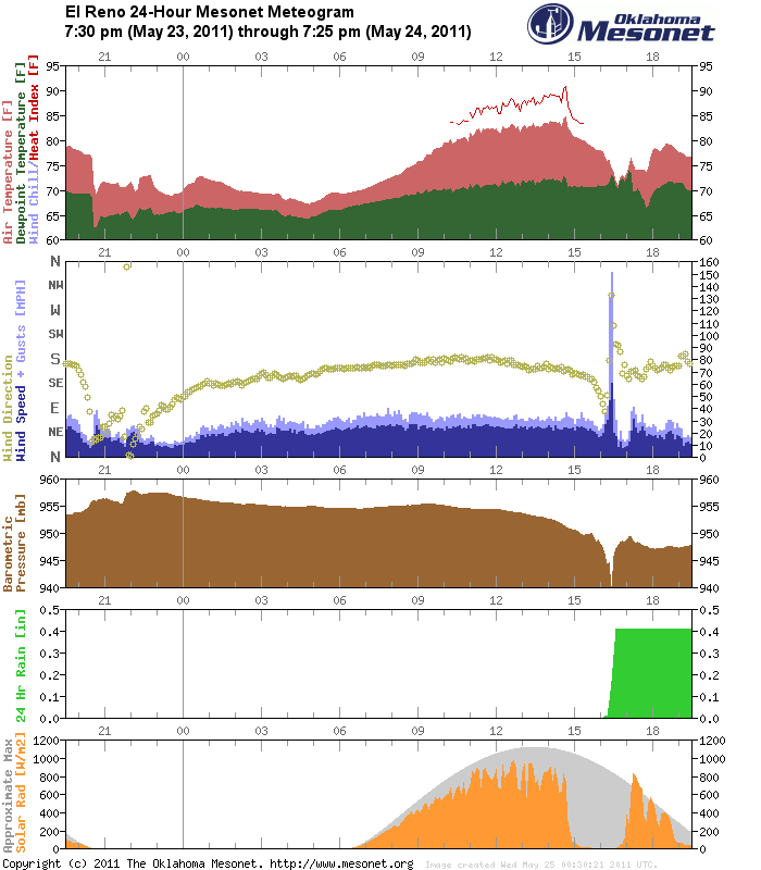