
A heat wave over the Southwest will intensify this week, peaking and expanding into the Intermountain West and northern High Plains this weekend. Critical to extremely critical fire weather conditions are forecast from the Northwest and the northern Great Basin this weekend. Particularly Dangerous Situation Red Flag Warnings have been issued. Read More >
Overview
|
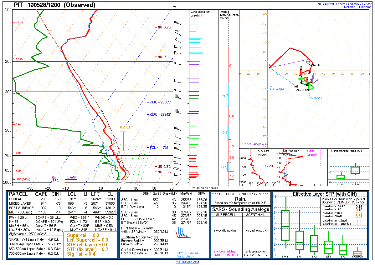
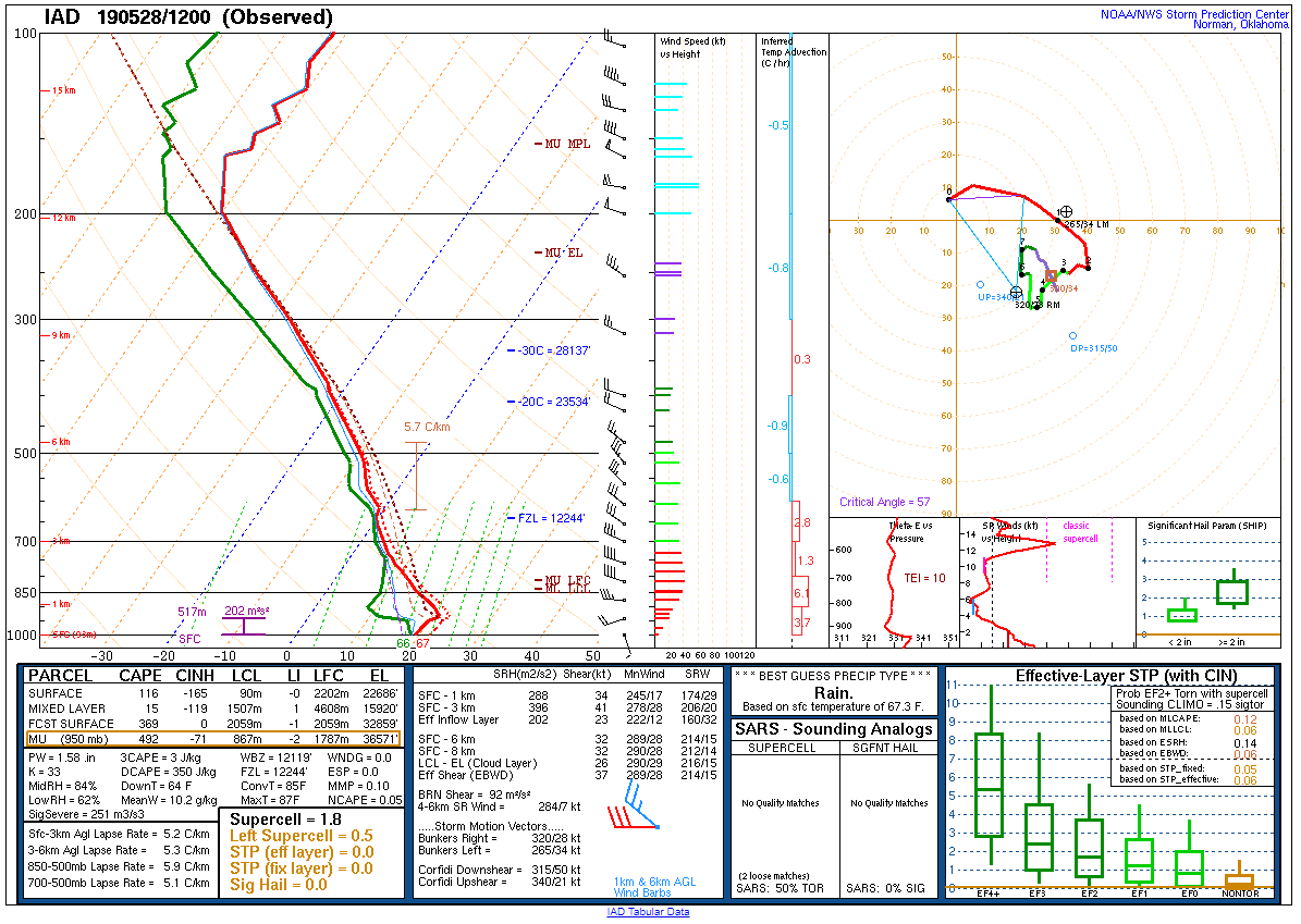
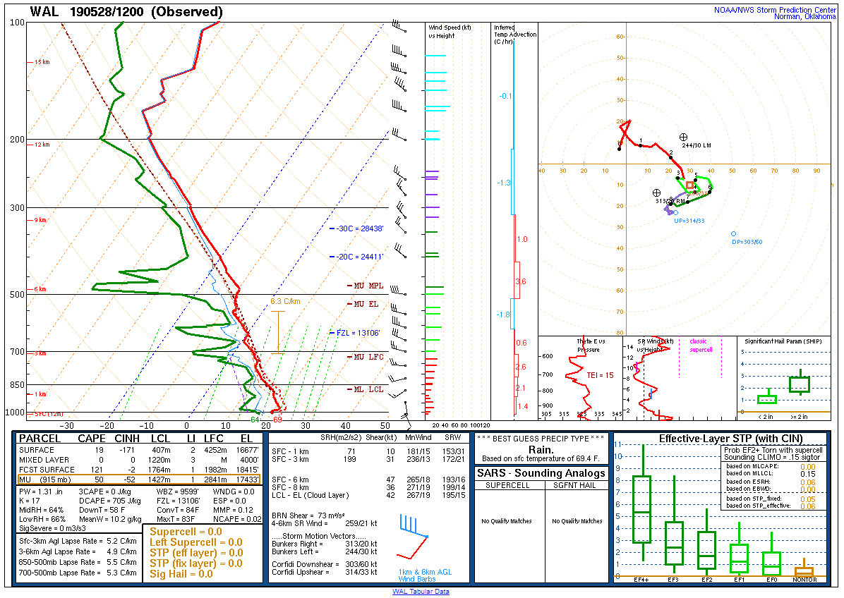
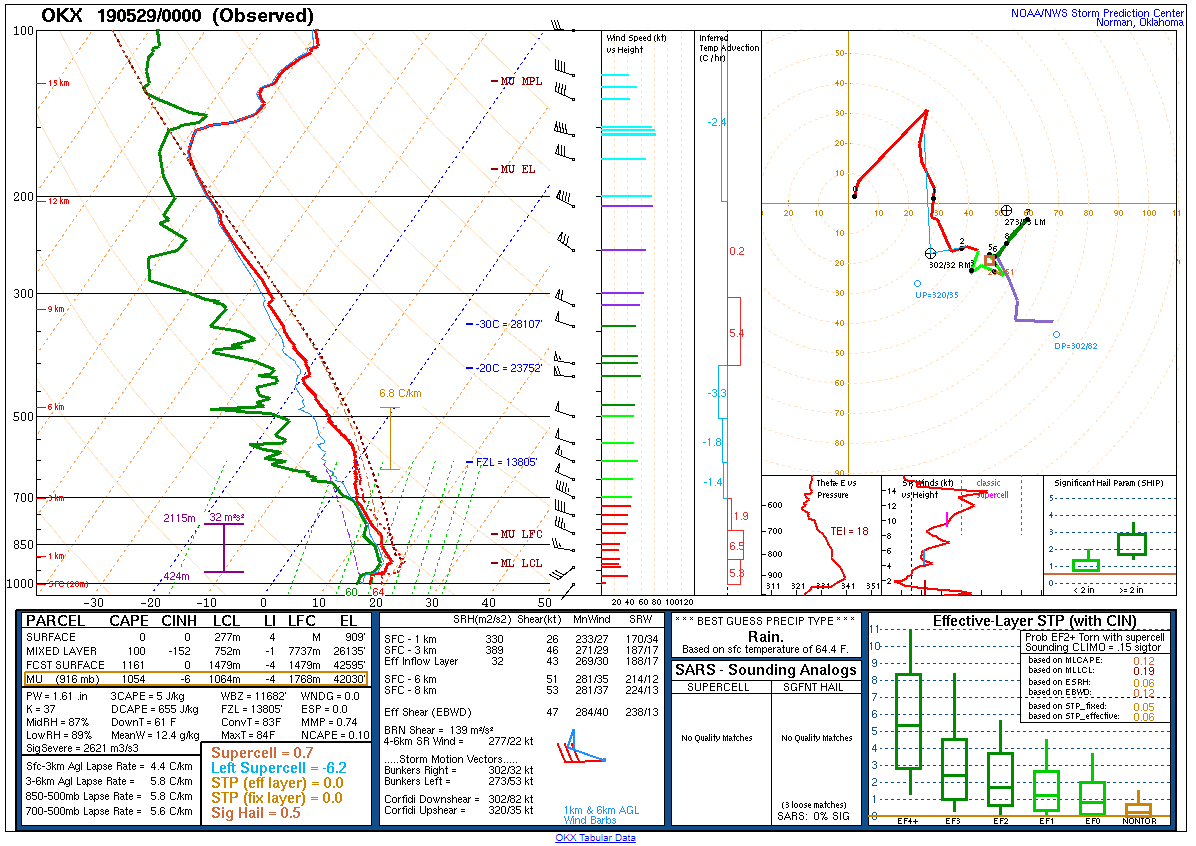
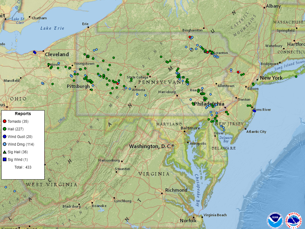
Severe storms developed during the afternoon of 28 May 2019 in western and central Pennsylvania, in a warm sector characterized by MLCAPE 1500-2500+ J/kg, effective bulk shear of 40-50+ kts, and low-level helicity 150+ J/kg. The combination of these ingredients is rare in this region, and quite favorable for supercells capable of producing very large hail, wind damage, and tornadoes. Aided by weak midlevel perturbations providing large-scale lift in the Mid-Atlantic and a warm front draped across the area, the storms to our west became severe quickly and moved into the region by early evening. Of particular note were two long-lived supercells traversing the Berks County to far southern New Jersey corridor, where swaths of large hail (up to two inches in diameter) were reported as well as an EF2 tornado in Morgantown, PA, and a waterspout in Delaware Bay just south of Cumberland County, NJ. An additional supercell near the aforementioned warm front produced a brief but damaging (EF1) tornado in Sussex County, NJ. |
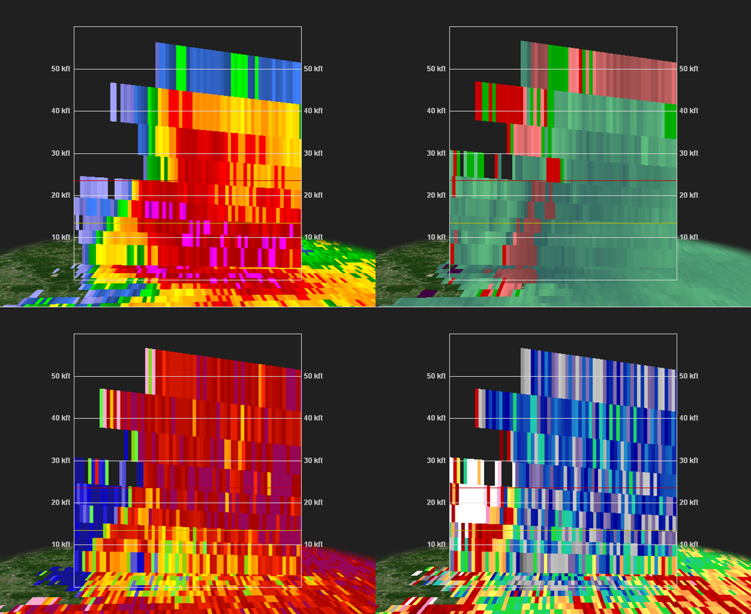
 Composite radar loop of the Morgantown tornado on 28 May 2019. |
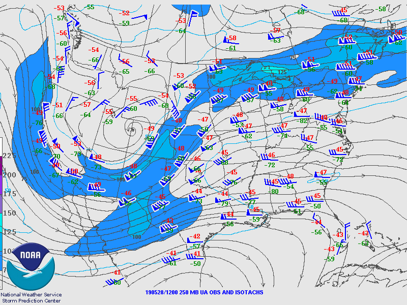
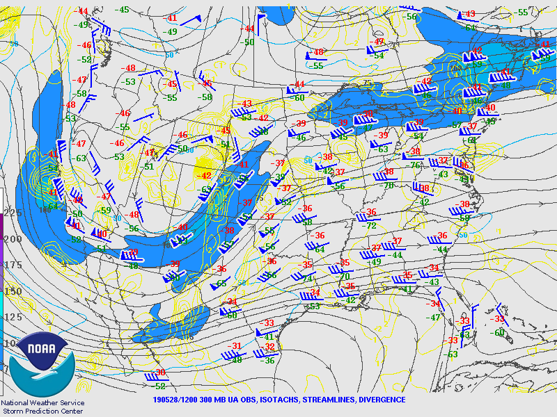
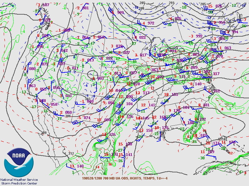
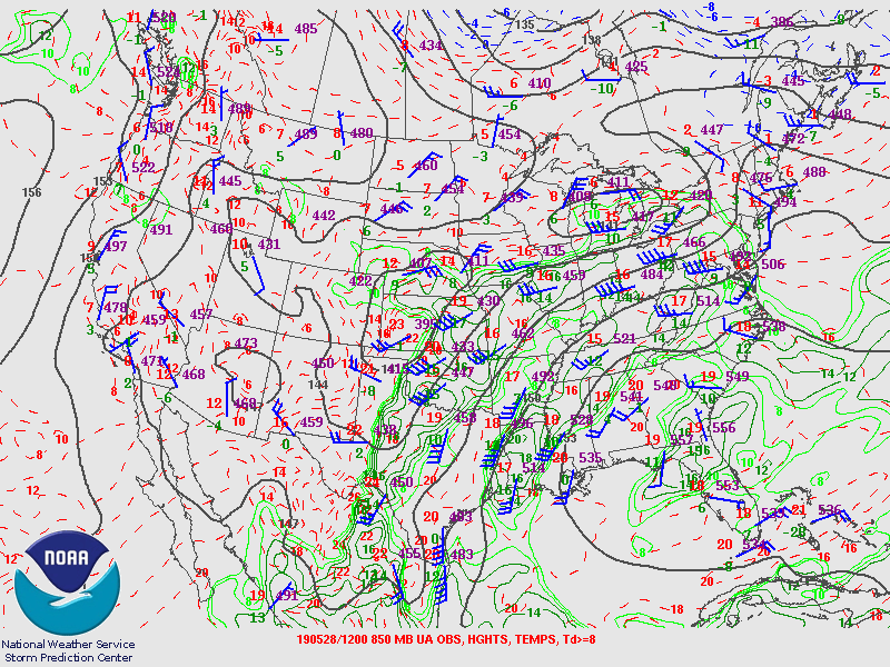
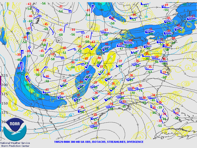
Synoptic Overview at 12z 28 May 2019 (courtesy of SPC)
 |
 |
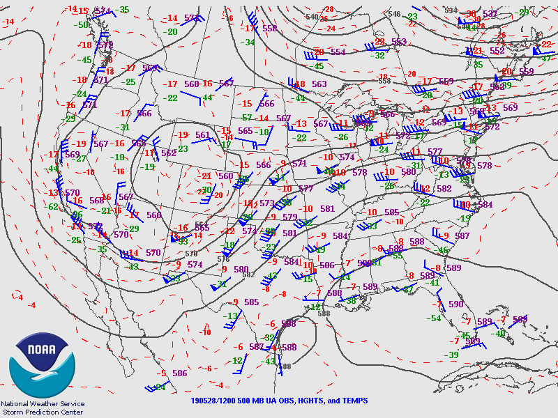 |
| Figure 1: 250-mb analysis | Figure 2: 300-mb analysis | Figure 3: 500-mb analysis |
 |
 |
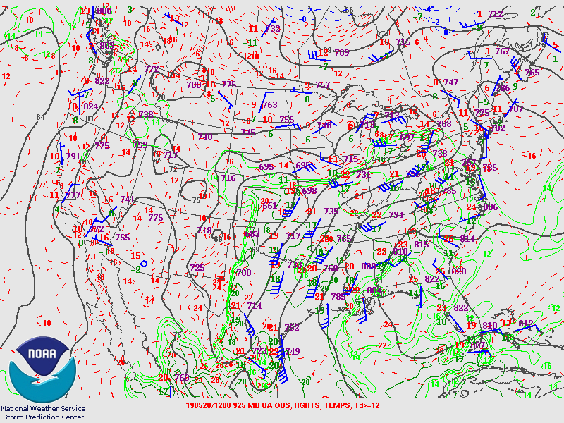 |
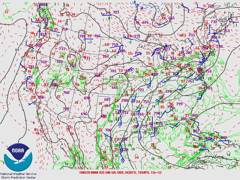
| Figure 4: 700-mb analysis | Figure 5: 850-mb analysis | Figure 6: 925-mb analysis |
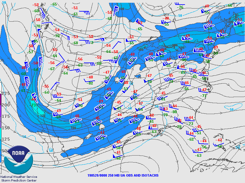
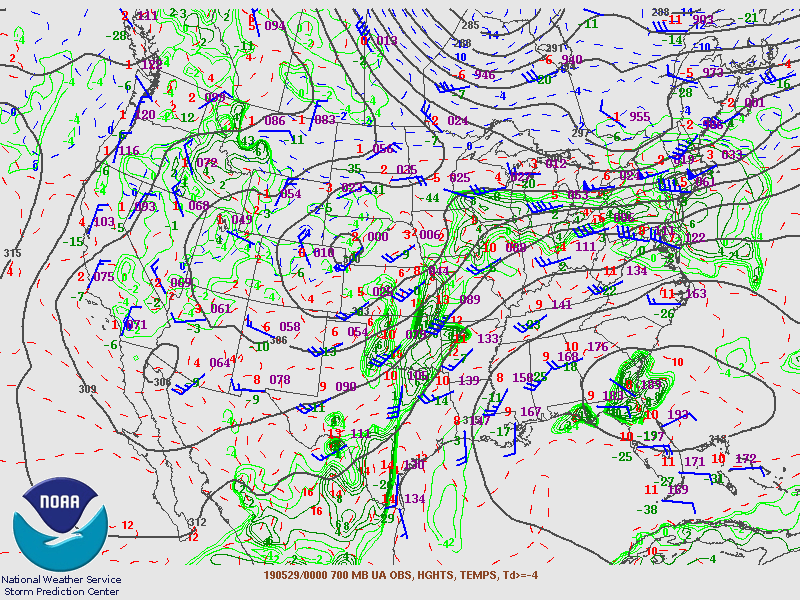
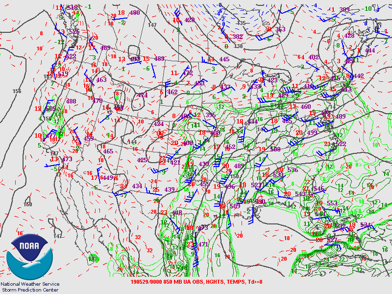
Synoptic Overview at 00z 29 May 2019 (courtesy of SPC)
 |
 |
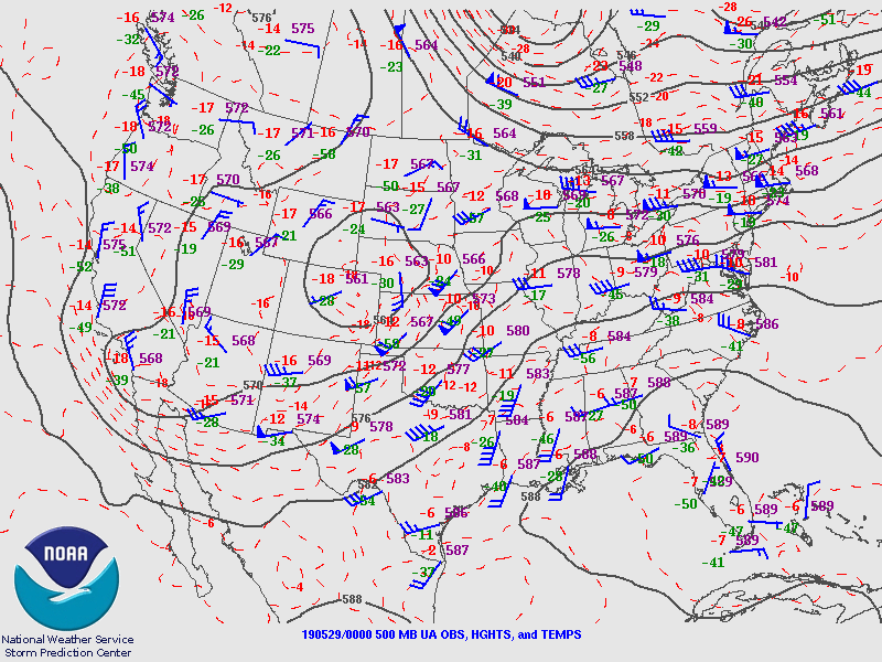 |
| Figure 7: 250-mb analysis | Figure 8: 300-mb analysis | Figure 9: 500-mb analysis |
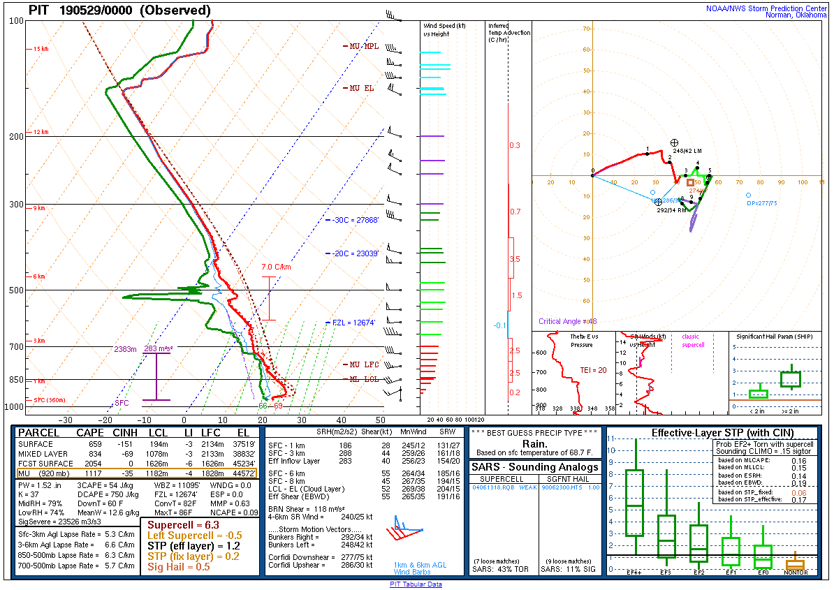
 |
 |
 |
| Figure 10: 700-mb analysis | Figure 11: 850-mb analysis | Figure 12: 925-mb analysis |
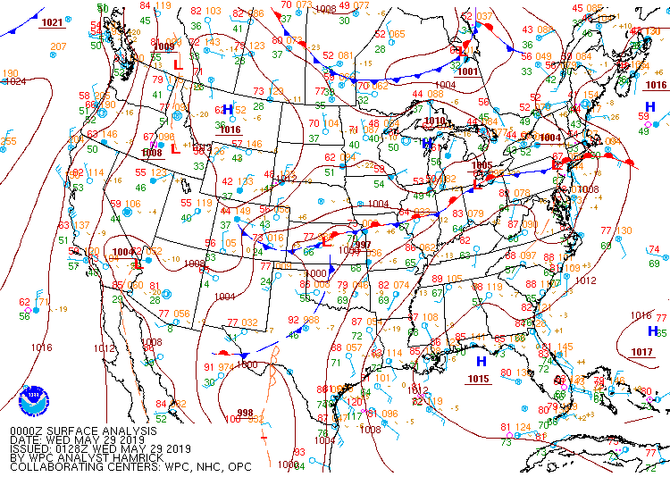
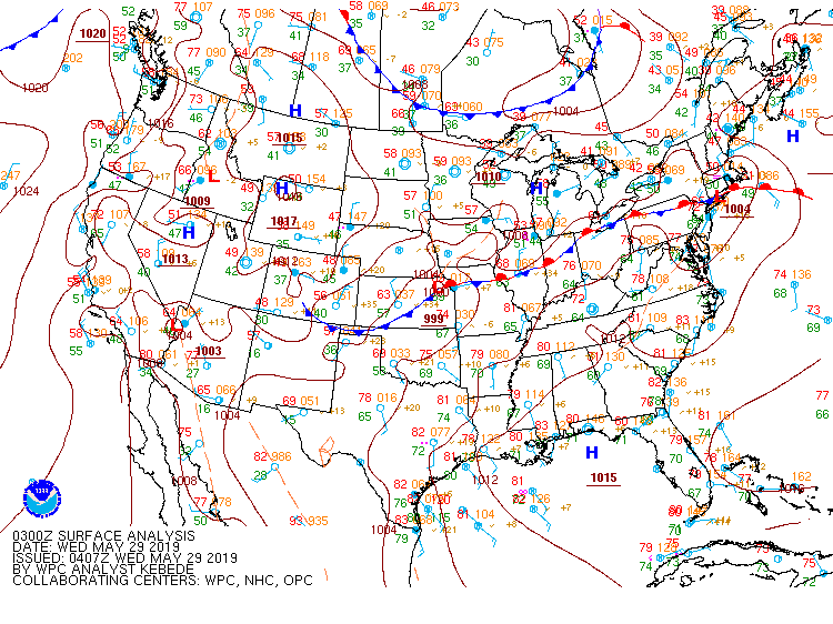
Surface Maps (courtesy of WPC)
 |
 |
 |
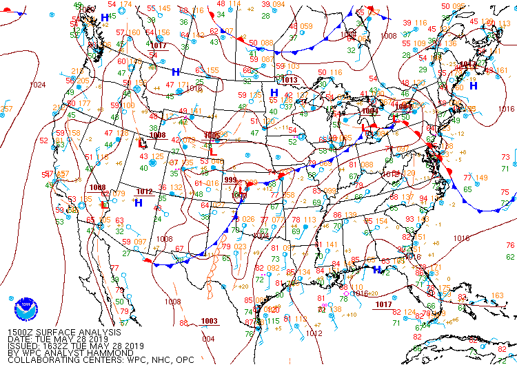
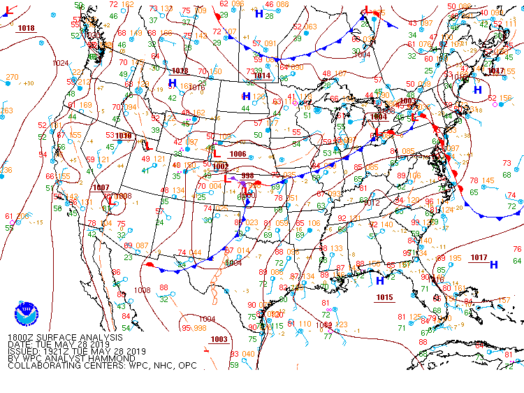
| Figure 13: 15z surface map | Figure 14: 18z surface map | Figure 15: 21z surface map |
 |
 |
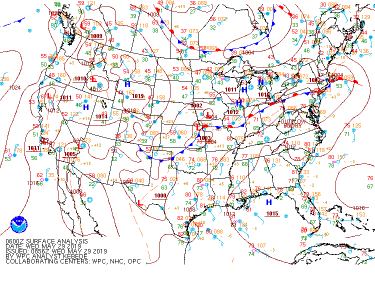 |
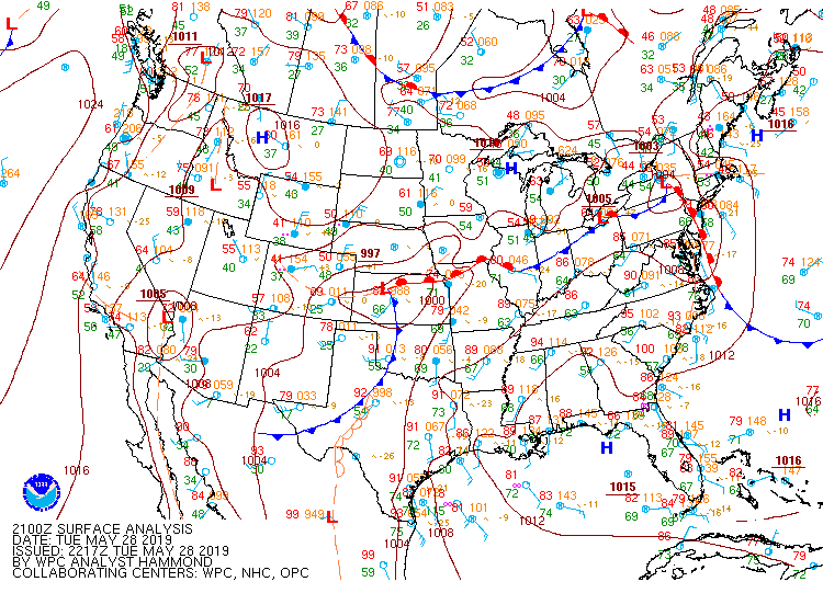
| Figure 16: 00z surface map | Figure 17: 03z surface map | Figure 18: 06z surface map |
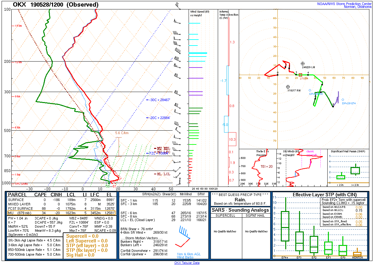 |
 |
| Figure 19: 12z Upton, NY sounding | Figure 20: 12z Pittsburgh, PA sounding |
 |
 |
| Figure 21: 12z Sterling, VA sounding | Figure 22: 12z Wallops Island, VA sounding |
 |
 |
| Figure 23: 00z Upton, NY sounding | Figure 24: 00z Pittsburgh, PA sounding |
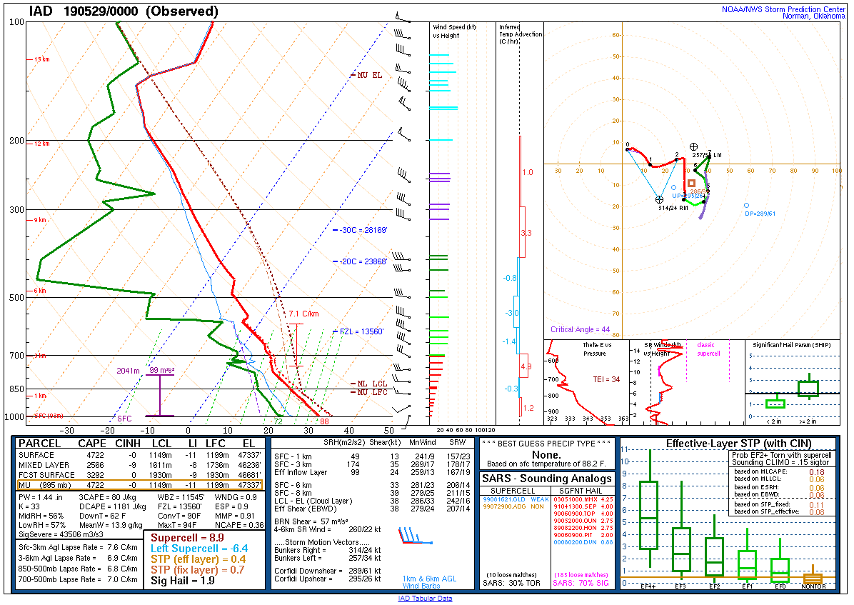 |
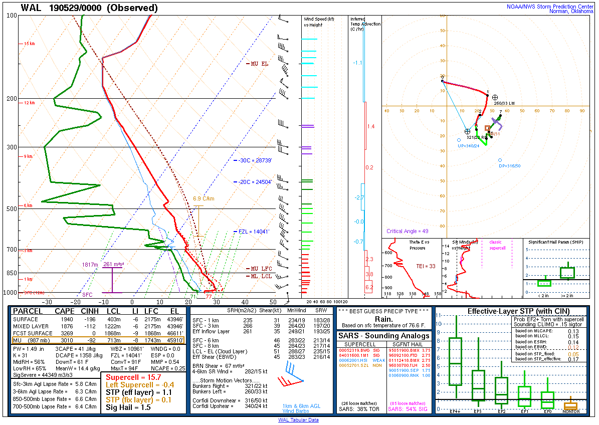 |
| Figure 25: 00z Sterling, VA sounding | Figure 26: 00z Wallops Island, VA sounding |
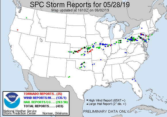 |
 |
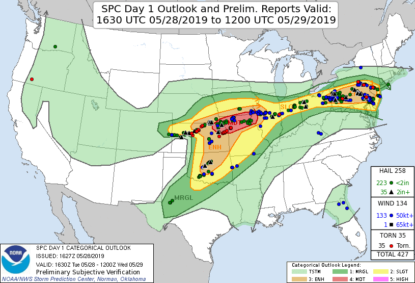 |
| Figure 1: National Preliminary Reports 12z 28 May 2019 to 12z 29 May 2019 | Figure 2: Zoomed Preliminary Reports for the same period. | Figure 3: Prelim Reports vs. 1630z SPC Convective Outlook |
Click here for a county warning area based look at local storm reports and warnings/advisories issued during the 28 May 2019 event.
Tornado Watch 0274
Severe Thunderstorm Warning 0057
Severe Thunderstorm Warning 0058
Severe Thunderstorm Warning 0059
Tornado Warning 0012
Severe Thunderstorm Warning 0060
Severe Thunderstorm Warning 0061
Areal Flood Advisory 0054
Tornado Warning 0013
Severe Thunderstorm Warning 0062
Special Marine Warning 0037
Areal Flood Advisory 0055
Severe Thunderstorm Warning 0063
Severe Thunderstorm Warning 0064
Severe Thunderstorm Warning 0065
Severe Thunderstorm Warning 0066
Severe Thunderstorm Warning 0067
Areal Flood Advisory 0056
Severe Thunderstorm Warning 0068
Severe Thunderstorm Warning 0069
Severe Thunderstorm Warning 0070
Severe Thunderstorm Warning 0071
Areal Flood Advisory 0057
Tornado Warning 0014
Areal Flood Advisory 0058
Tornado Warning 0015
Tornado Warning 0016
Special Marine Warning 0038
Severe Thunderstorm Warning 0072
Severe Thunderstorm Warning 0073
Severe Thunderstorm Warning 0074
Special Marine Warning 0039
Areal Flood Advisory 0059
River Flood Warning 0009
Areal Flood Advisory 0060
Special Marine Warning 0040
Severe Thunderstorm Warning 0075
Special Marine Warning 0041
Special Marine Warning 0042
Severe Thunderstorm Warning 0076
Special Marine Warning 0043
Severe Thunderstorm Warning 0077
Special Marine Warning 0044
NWUS51 KPHI 021609
LSRPHI

PRELIMINARY LOCAL STORM REPORT...SUMMARY
NATIONAL WEATHER SERVICE MOUNT HOLLY NJ
1209 PM EDT SUN JUN 2 2019

..TIME...   ...EVENT...      ...CITY LOCATION...     ...LAT.LON...
..DATE...   ....MAG....      ..COUNTY LOCATION..ST.. ...SOURCE....
            ..REMARKS..

0501 PM     HAIL             BERNVILLE               40.43N 76.11W
05/28/2019  E1.00 INCH       BERKS              PA   PUBLIC

            TIME ESTIMATED FROM RADAR.

0509 PM     HAIL             NORTH HEIDELBERG TWP    40.39N 76.12W
05/28/2019  E1.00 INCH       BERKS              PA   PUBLIC

            TIME ESTIMATED FROM RADAR.

0510 PM     HAIL             ROBESONIA               40.35N 76.13W
05/28/2019  M0.75 INCH       BERKS              PA   TRAINED SPOTTER


0530 PM     HAIL             SINKING SPRING          40.33N 76.02W
05/28/2019  M1.00 INCH       BERKS              PA   PUBLIC


0530 PM     HAIL             SINKING SPRING          40.33N 76.01W
05/28/2019  E1.25 INCH       BERKS              PA   PUBLIC


0532 PM     HAIL             WYOMISSING              40.33N 75.96W
05/28/2019  M0.88 INCH       BERKS              PA   TRAINED SPOTTER


0533 PM     HAIL             1 S WEST WYOMISSING     40.32N 75.99W
05/28/2019  E1.25 INCH       BERKS              PA   COCORAHS


0535 PM     HAIL             WYOMISSING              40.33N 75.96W
05/28/2019  E1.50 INCH       BERKS              PA   PUBLIC


0536 PM     HAIL             WYOMISSING              40.33N 75.96W
05/28/2019  M1.75 INCH       BERKS              PA   PUBLIC


0536 PM     HAIL             WYOMISSING              40.34N 75.96W
05/28/2019  E1.00 INCH       BERKS              PA   PUBLIC


0545 PM     HAIL             WEST LAWN               40.33N 75.99W
05/28/2019  E1.75 INCH       BERKS              PA   PUBLIC


0550 PM     HAIL             READING                 40.33N 75.92W
05/28/2019  M1.00 INCH       BERKS              PA   PUBLIC


0552 PM     TORNADO          MORGANTOWN              40.16N 75.89W
05/28/2019                   BERKS              PA   NWS STORM SURVEY

            MAXIMUM EF SCALE RATING EF2 WITH ESTIMATED
            MAXIMUM WINDS OF 120 MPH.

0553 PM     HAIL             3 ENE NEW MORGAN        40.20N 75.84W
05/28/2019  E1.75 INCH       BERKS              PA   PUBLIC

            TIME ESTIMATED FROM RADAR.

0555 PM     HAIL             MORGANTOWN              40.16N 75.89W
05/28/2019  E2.00 INCH       BERKS              PA   PUBLIC


0556 PM     TSTM WND DMG     CAERNARVON TWP          40.15N 75.88W
05/28/2019                   BERKS              PA   911 CALL CENTER

            POSSIBLE TORNADO DAMAGE IN CAERNARVON TWP
            AND MORGANTOWN WITH BUILDINGS AND HOMES
            DAMAGED AND NUMEROUS TREES DOWN. TIME
            ESTIMATED FROM RADAR.

0559 PM     TSTM WND GST     MORGANTOWN              40.15N 75.89W
05/28/2019  M88 MPH          BERKS              PA   MESONET

            MEASURED BY PERSONAL WEATHER STATION IN
            CLOSE PROXIMITY TO THE TORNADO THAT MOVED
            THROUGH TOWN. THIS WAS THE LAST AVAILABLE
            OBSERVATION BEFORE A POWER OUTAGE OCCURRED.
            TIME OF OBSERVATION WAS BETWEEN 5:54 AND
            5:59 PM.

0604 PM     HAIL             2 NNW NEW MORGAN        40.22N 75.91W
05/28/2019  M1.50 INCH       BERKS              PA   PUBLIC


0612 PM     TSTM WND DMG     MOHRSVILLE              40.48N 75.98W
05/28/2019                   BERKS              PA   FIRE DEPT/RESCUE

            DOWNED TREE ON EASTER STREET NEAR MAIN
            STREET IN CENTRE TWP. TIME ESTIMATED FROM
            RADAR.

0625 PM     TSTM WND DMG     1 NNW WEST CHESTER      39.98N 75.61W
05/28/2019                   CHESTER            PA   EMERGENCY MNGR

            TREE DOWN AT OWEN ROAD AND KIRBY DRIVE IN
            WEST GOSHEN TWP. ALL LANES CLOSED. TIME
            ESTIMATED FROM RADAR.

0628 PM     HAIL             1 N WEST CHESTER        39.98N 75.60W
05/28/2019  E1.00 INCH       CHESTER            PA   PUBLIC


0628 PM     TSTM WND DMG     1 WNW DOWNINGTON        40.01N 75.72W
05/28/2019                   CHESTER            PA   EMERGENCY MNGR

            DOWNED TREE BLOCKING THE SOUTHBOUND LANE OF
            ROCK RAYMOND DRIVE NEAR THE U.S. 30 BYPASS.
            TIME ESTIMATED FROM RADAR.

0630 PM     HAIL             EXTON                   40.03N 75.63W
05/28/2019  M1.00 INCH       CHESTER            PA   TRAINED SPOTTER


0633 PM     TSTM WND DMG     1 NNE SOUTH COATESVILLE 39.99N 75.80W
05/28/2019                   CHESTER            PA   EMERGENCY MNGR

            LARGE TREE BLOWN DOWN NEAR THE INTERSECTION
            OF FOUNDRY ROAD AND FOUNDRY STREET IN CALN
            TWP. TIME ESTIMATED FROM RADAR.

0633 PM     TSTM WND DMG     1 S DOUGLASS TWP        40.31N 75.68W
05/28/2019                   BERKS              PA   FIRE DEPT/RESCUE

            DOWNED TREE AND WIRES ON RED SHALE DRIVE.
            TIME ESTIMATED FROM RADAR.

0635 PM     HAIL             1 N GLASGOW             39.62N 75.75W
05/28/2019  M1.00 INCH       NEW CASTLE         DE   TRAINED SPOTTER

            CORRECTS PREVIOUS HAIL REPORT FROM 1 N
            GLASGOW TO ACCOUNT FOR AN INCREASE IN HAIL
            SIZE FOLLOWING THE INITIAL REPORT.

0635 PM     TSTM WND DMG     1 SE EXTON              40.02N 75.62W
05/28/2019                   CHESTER            PA   DEPT OF HIGHWAYS

            TREE DOWN ON PA-100.

0636 PM     TSTM WND DMG     1 WSW EAST FALLOWFIELD  39.94N 75.84W
05/28/2019                   CHESTER            PA   EMERGENCY MNGR

            LARGE TREE DOWN BLOCKING ALL OF BUCK RUN
            ROAD NEAR GLENROSE ROAD. TIME ESTIMATED FROM
            RADAR.

0638 PM     TSTM WND DMG     1 W EAST GOSHEN TWP.    39.99N 75.56W
05/28/2019                   CHESTER            PA   EMERGENCY MNGR

            TREE DOWN BLOCKING MEADOWBROOK LANE NEAR
            BOOT ROAD. TIME ESTIMATED FROM RADAR.

0641 PM     TSTM WND DMG     1 SSE PAOLI             40.03N 75.48W
05/28/2019                   CHESTER            PA   EMERGENCY MNGR

            DOWNED TREE ON WEATHERSTONE DRIVE NEAR
            VALLEY ROAD IN WILLISTOWN TWP. TIME
            ESTIMATED FROM RADAR.

0641 PM     HAIL             DELAWARE CITY           39.57N 75.59W
05/28/2019  E1.25 INCH       NEW CASTLE         DE   PUBLIC

            TIME ESTIMATED FROM RADAR.

0644 PM     HAIL             1 NNE WEST GOSHEN       39.99N 75.57W
05/28/2019  M0.70 INCH       CHESTER            PA   DEPT OF HIGHWAYS


0648 PM     HAIL             SAINT GEORGES           39.56N 75.65W
05/28/2019  M1.50 INCH       NEW CASTLE         DE   PUBLIC


0649 PM     TSTM WND DMG     1 SSW EAST GOSHEN TWP.  39.99N 75.55W
05/28/2019                   CHESTER            PA   EMERGENCY MNGR

            TREE DOWN BLOCKING BARKER DRIVE AT MARYDELL
            DRIVE. TIME ESTIMATED FROM RADAR.

0654 PM     TSTM WND DMG     3 ESE KENNETT SQUARE    39.83N 75.67W
05/28/2019                   CHESTER            PA   EMERGENCY MNGR

            LARGE TREE DOWN DAMAGING TWO VEHICLES NEAR
            THE INTERSECTION OF NINE GATES ROAD AND OLD
            KENNETT ROAD IN KENNETT TWP. TIME ESTIMATED
            FROM RADAR.

0702 PM     TSTM WND DMG     CLAYMONT                39.80N 75.46W
05/28/2019                   NEW CASTLE         DE   BROADCAST MEDIA

            *** 1 INJ ***
            A TREE FELL ONTO A TENT AT A CHURCH
            FESTIVAL. THE TREE STRUCK AND INJURED A
            MUSICIAN PLAYING INSIDE THE TENT AT THE
            TIME. TIME ESTIMATED FROM RADAR.

0705 PM     HAIL             SALEM                   39.58N 75.47W
05/28/2019  M1.00 INCH       SALEM              NJ   PUBLIC


0715 PM     HAIL             CLELAND HEIGHTS         39.74N 75.57W
05/28/2019  M0.70 INCH       NEW CASTLE         DE   PUBLIC


0717 PM     TSTM WND DMG     DUNLINDEN ACRES         39.74N 75.64W
05/28/2019                   NEW CASTLE         DE   EMERGENCY MNGR

            TREE INTO A HOUSE ON DUNCAN RD. TIME
            ESTIMATED FROM RADAR.

0720 PM     HAIL             ELMHURST                39.73N 75.59W
05/28/2019  M0.75 INCH       NEW CASTLE         DE   TRAINED SPOTTER


0723 PM     HAIL             BRIDGETON               39.43N 75.23W
05/28/2019  E0.88 INCH       CUMBERLAND         NJ   PUBLIC


0728 PM     HAIL             CARNEYS POINT TWP       39.72N 75.47W
05/28/2019  E1.00 INCH       SALEM              NJ   PUBLIC

            TIME ESTIMATED FROM RADAR.

0735 PM     HAIL             PENNSVILLE              39.66N 75.52W
05/28/2019  M1.00 INCH       SALEM              NJ   TRAINED SPOTTER


0740 PM     HAIL             PENNSVILLE              39.65N 75.52W
05/28/2019  E1.50 INCH       SALEM              NJ   PUBLIC


0742 PM     HAIL             SALEM                   39.57N 75.46W
05/28/2019  M1.50 INCH       SALEM              NJ   COCORAHS


0802 PM     TSTM WND DMG     1 W HOPEWELL TWP.       39.44N 75.29W
05/28/2019                   CUMBERLAND         NJ   EMERGENCY MNGR

            EMERGENCY MANAGEMENT REPORTS NUMEROUS TREES
            DOWN WEST OF BRIDGETON IN THE AREA OF
            ROADSTOWN ROAD AND RANDOLPH ROAD.

0806 PM     TSTM WND DMG     2 SSW SHILOH            39.44N 75.31W
05/28/2019                   CUMBERLAND         NJ   EMERGENCY MNGR

            SEVERAL REPORTS OF ABOUT 10 POWER POLES
            SNAPPED ALONG ROADSTOWN ROAD BETWEEN
            RANDOLPH ROAD AND ROADSTOWN. TIME ESTIMATED
            FROM RADAR.

0814 PM     TSTM WND DMG     1 N FAIRTON             39.39N 75.22W
05/28/2019                   CUMBERLAND         NJ   PUBLIC

            A FEW TREES DOWN IN FAIRTON.

0820 PM     TSTM WND DMG     CEDARVILLE              39.33N 75.20W
05/28/2019                   CUMBERLAND         NJ   PUBLIC

            MULTIPLE TREES AND POWER LINES DOWN. TIME
            ESTIMATED FROM RADAR.

0825 PM     TSTM WND GST     1 ENE STANHOPE          40.92N 74.68W
05/28/2019  M50 MPH          SUSSEX             NJ   TRAINED SPOTTER

            MEASURED WIND GUST OF 50 MPH BEFORE POWER
            WENT OUT. GUSTS BECAME HIGHER AFTER THE
            POWER WENT OUT.

0825 PM     HAIL             HOPATCONG               40.94N 74.66W
05/28/2019  E0.70 INCH       SUSSEX             NJ   PUBLIC


0830 PM     TORNADO          STANHOPE                40.92N 74.70W
05/28/2019                   SUSSEX             NJ   NWS STORM SURVEY

            MAXIMUM EF SCALE RATING EF1 WITH ESTIMATED
            MAXIMUM WINDS OF 100 MPH.

0830 PM     TSTM WND DMG     1 W MOUNT ARLINGTON     40.93N 74.65W
05/28/2019                   MORRIS             NJ   PUBLIC

            POSSIBLE TORNADO DAMAGE ON BERTRAND ISLAND
            IN MOUNT ARLINGTON. TIME ESTIMATED FROM
            RADAR.

0832 PM     WATER SPOUT      2 SW FORTESCUE          39.21N 75.20W
05/28/2019                   ANZ430             NJ   PUBLIC

            SEVERAL PICTURES AND VIDEOS SHOW A WATER
            SPOUT JUST OFFSHORE FROM FORTESCUE. TIME
            ESTIMATED FROM RADAR.

0832 PM     FUNNEL CLOUD     3 NW MENDHAM            40.81N 74.63W
05/28/2019                   MORRIS             NJ   TRAINED SPOTTER

            TRAINED SPOTTER REPORTED A FUNNEL CLOUD AT
            THE BASE OF A ROTATING THUNDERSTORM.

0838 PM     HAIL             DEPTFORD TWP            39.83N 75.12W
05/28/2019  M1.25 INCH       GLOUCESTER         NJ   TRAINED SPOTTER


0838 PM     HAIL             1 E DEPTFORD TWP        39.83N 75.10W
05/28/2019  E1.00 INCH       GLOUCESTER         NJ   PUBLIC


0840 PM     HAIL             RANDOLPH, NJ            40.85N 74.57W
05/28/2019  E1.00 INCH       MORRIS             NJ   PUBLIC


0840 PM     MARINE TSTM WIND FORTESCUE               39.24N 75.18W
05/28/2019  M49 MPH          CUMBERLAND         NJ   MESONET

            NJWXNET GAUGE.

0841 PM     HAIL             SEWELL                  39.77N 75.15W
05/28/2019  M0.70 INCH       GLOUCESTER         NJ   TRAINED SPOTTER


0843 PM     HAIL             DENVILLE                40.86N 74.50W
05/28/2019  E1.25 INCH       MORRIS             NJ   PUBLIC

            HALF DOLLAR SIZE HAIL. TIME ESTIMATED FROM
            RADAR.

0846 PM     HAIL             TURNERSVILLE            39.77N 75.06W
05/28/2019  M1.00 INCH       GLOUCESTER         NJ   BROADCAST MEDIA


0846 PM     TSTM WND DMG     2 NE HOPE               40.94N 74.95W
05/28/2019                   WARREN             NJ   FIRE DEPT/RESCUE

            POSSIBLE TORNADO DAMAGE WITH SEVERAL TREES
            UPROOTED AND SNAPPED IN THE SILVER LAKE AREA
            OF HOPE TWP. TREES HAVE FALLEN ONTO HOMES
            AND VEHICLES. REPORTS OF A FUNNEL CLOUD IN
            THE AREA AT THE TIME. TIME ESTIMATED FROM
            RADAR.

0853 PM     TSTM WND DMG     BLAIRSTOWN TWP          40.99N 74.95W
05/28/2019                   WARREN             NJ   DEPT OF HIGHWAYS

            TREES AND POWER LINES DOWN ON CEDAR LAKE RD
            AND MOUNT HERMON RD.

0900 PM     TSTM WND DMG     BLAIRSTOWN TWP          40.99N 74.95W
05/28/2019                   WARREN             NJ   DEPT OF HIGHWAYS

            TREE DOWN BLOCKING ROADWAY AT ROUTE 94 AND
            VAIL RD.

0956 PM     HAIL             2 WSW LAKEHURST         40.00N 74.34W
05/28/2019  E1.00 INCH       OCEAN              NJ   PUBLIC


0958 PM     HAIL             3 ESE LAKEHURST         40.00N 74.26W
05/28/2019  E1.75 INCH       OCEAN              NJ   PUBLIC


1009 PM     HAIL             LANOKA HARBOR           39.87N 74.16W
05/28/2019  E0.70 INCH       OCEAN              NJ   PUBLIC


1149 PM     MARINE TSTM WIND 1 ENE LANOKA HARBOR     39.87N 74.14W
05/28/2019  M58 MPH          OCEAN              NJ   MESONET


1149 PM     TSTM WND GST     1 ENE LANOKA HARBOR     39.87N 74.14W
05/28/2019  M58 MPH          OCEAN              NJ   MESONET

            WEATHERFLOW SENSOR.

1150 PM     TSTM WND GST     4 ESE LANOKA HARBOR     39.85N 74.09W
05/28/2019  M62 MPH          OCEAN              NJ   MESONET


1156 PM     MARINE TSTM WIND 1 E BARNEGAT LIGHT      39.76N 74.09W
05/28/2019  M44 MPH          ANZ451             NJ   MESONET


1157 PM     MARINE TSTM WIND SEASIDE HEIGHTS         39.95N 74.07W
05/28/2019  M47 MPH          ANZ451             NJ   MESONET

            DELAYED REPORT FROM TUESDAY.


&&

$$

CMS
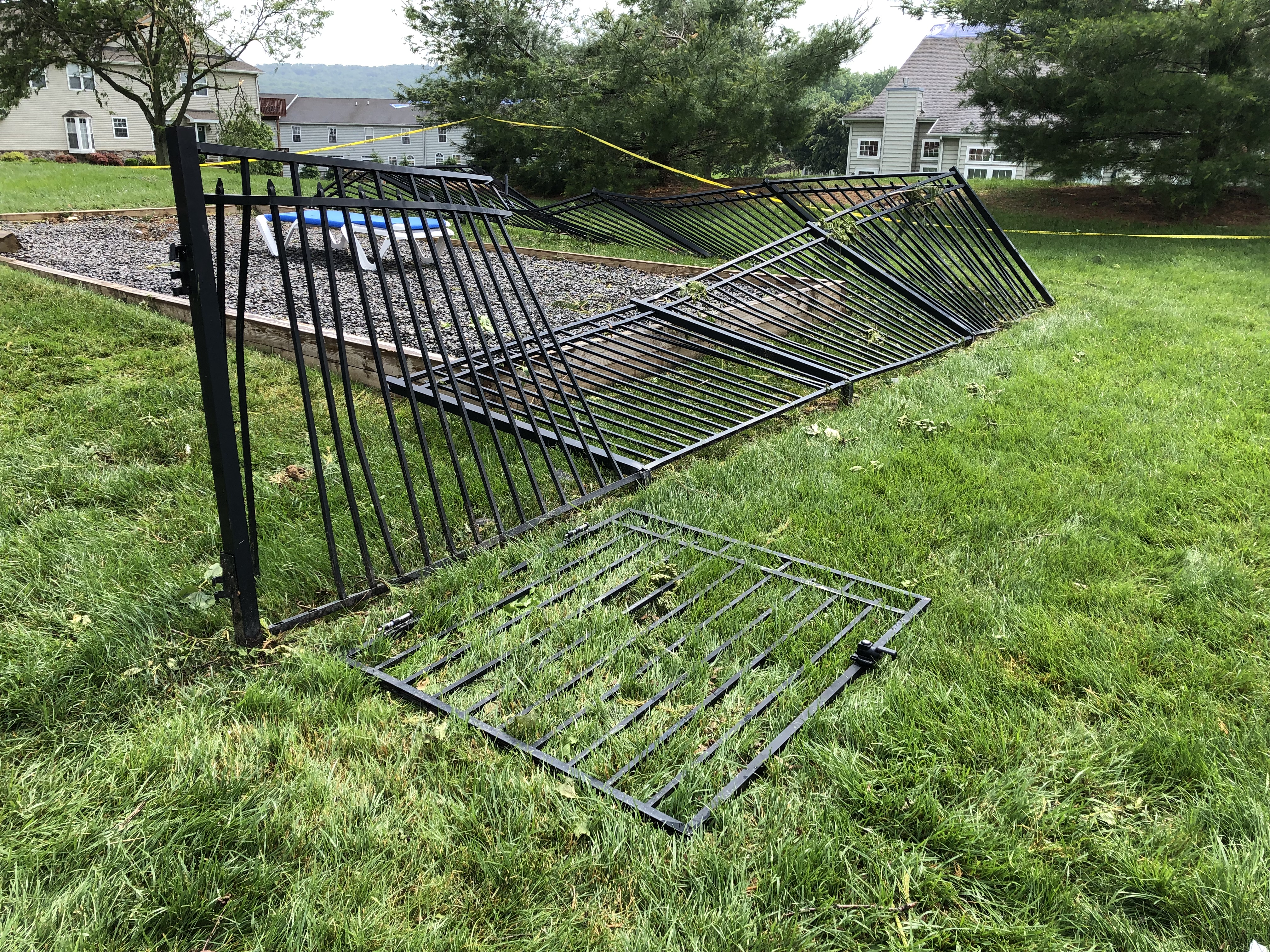
NOUS41 KPHI 300117
PNSPHI
DEZ001>004-MDZ008-012-015-019-020-NJZ001-007>010-012>027-PAZ054-
055-060>062-070-071-101>106-301330-

Public Information Statement
National Weather Service Mount Holly NJ
917 PM EDT Wed May 29 2019

...NWS DAMAGE SURVEYS FOR THE 05/28/19 TORNADO EVENT...

.Morgantown Pennsylvania Tornado...

Start Location...Caernarvon Township in Lancaster County, PA
End Location...Caernarvon Township in Berks County, PA
Date...May 28, 2019
Estimated Time...5:52 PM EDT to 6:00 PM EDT
Maximum EF-Scale Rating...EF2
Estimated Maximum Wind Speed...120 mph
Maximum Path Width...400 yards
Path Length...2.6 miles
Beginning Lat/Lon...40.1589/-75.9096
Ending Lat/Lon...40.1468/-75.8658
* Fatalities...0
* Injuries...0

...Summary...
A tornado developed in Caernarvon Township in Lancaster
County, PA, approximately a quarter mile from the Berks County
line. Damage began at a turkey farm in this area, where several
trees were snapped and the roof of a barn was lofted and blown
to a residence on Swamp Road in Berks County. Forty turkeys were
killed at this location. The tornado then affected the Swamp
Road residence, with substantial damage to two outbuildings, one
of which was completely destroyed. The roof of one of the
outbuildings ended up underneath a van that was lofted
simultaneously. Additionally, a tractor trailer on the property
was overturned and dragged nearly 40 feet from its initial
position. The tornado then tracked through Morgantown, where
somewhat sporadic damage occurred to several businesses on Main
Street. The tornado then downed numerous large and healthy
trees on Mill Road and Mast Road. Several fallen trees severely
damaged a house on Mast Road. At this point, the tornado
shifted to a more southeast direction, where it moved into the
Valley Ponds subdivision. Several homes sustained roof and
window damage, at least a dozen vehicles were shifted and
severely damaged (one vehicle overturned several times, ending
up 30 to 40 feet from its original position), and numerous
trees were snapped and uprooted. From there, the tornado
tracked to an industrial park near Hemlock Road, where
numerous trees were snapped, three cars were shifted, and
several buildings sustained roof damage. Finally, the tornado
damaged several homes on Quarry View Drive. Two of the homes
had substantial damage to one or more exterior walls. The
tornado subsequently lifted near the end of Quarry View
Drive. No injuries were reported as a result of this tornado.

The survey team would like to thank Berks County Emergency
Management and the Caernarvon Township Supervisor for their
assistance in this survey.

.Stanhope New Jersey Tornado...

Start Location...Stanhope in Sussex County, New Jersey
End Location...Stanhope in Sussex County, New Jersey
Date...May 28, 2019
Estimated Time...8:30 PM EDT
Maximum EF-Scale Rating...EF1
Estimated Maximum Wind Speed...100 mph
Maximum Path Width...350 yards
Path Length...1.2 miles (discontinuous)
Beginning Lat/Lon...40.92/-74.70
Ending Lat/Lon...40.91/-74.68
* Fatalities...0
* Injuries...0

...Summary...
A tornado touched down in Stanhope in Sussex County, New Jersey.
Damage began near the Lenape Valley Regional High School. Here,
several trees were snapped or uprooted. On a field in front of the
school, a clear tornadic damage path was seen with three nearby
trees snapped or uprooted in a cyclonic fashion. A small but
anchored outbuilding was also lifted and flipped over. Further
tree damage occurred at a residence across the street from the
school. Damage then appeared to briefly abate, indicating the
tornado likely lifted for a short time. However, a short distance
further southeast, additional tornadic damage was observed with
numerous trees snapped or uprooted and several homes and cars
sustaining damage from falling trees on and around Unger Avenue.
Including the brief time when it likely lifted, the tornado lasted
approximately one to one and a half minutes. Thankfully, no
injuries were reported as a result of this tornado. We extend our
thanks to the Sussex County Division of Emergency Management,
Stanhope Emergency Management, and New Jersey State Police for
their assistance in this survey.

EF Scale: The Enhanced Fujita Scale classifies tornadoes into the
following categories:

EF0...Weak......65 to 85 mph
EF1...Weak......86 to 110 mph
EF2...Strong....111 to 135 mph
EF3...Strong....136 to 165 mph
EF4...Violent...166 to 200 mph
EF5...Violent...>200 mph

* The information in this statement is preliminary and subject to
change pending final review of the events and publication in NWS
Storm Data.

$$

Morgantown tornado:  Davis/CMS
Stanhope tornado:  Johnson/O'Brien
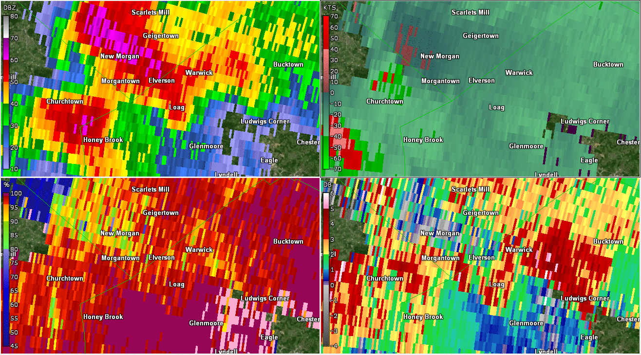
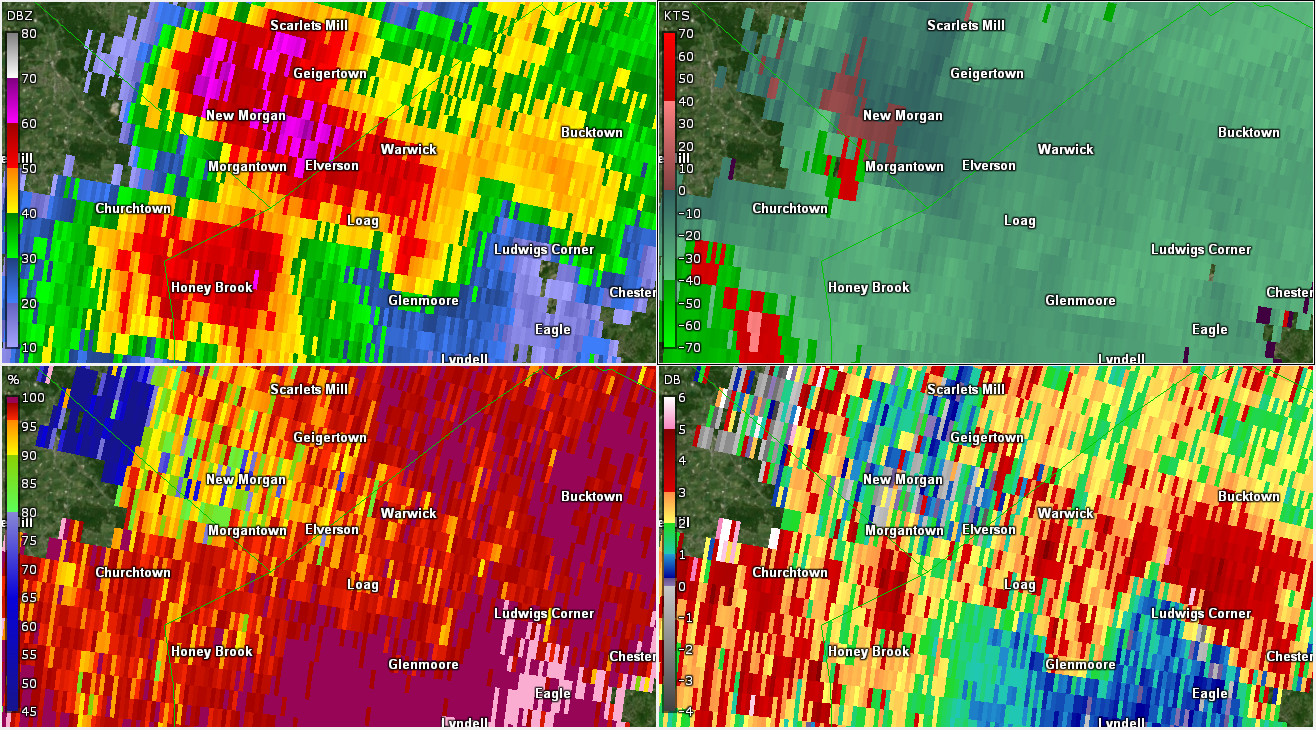
Morgantown Tornado and Large Hail (GR2Analyst)
 |
 |
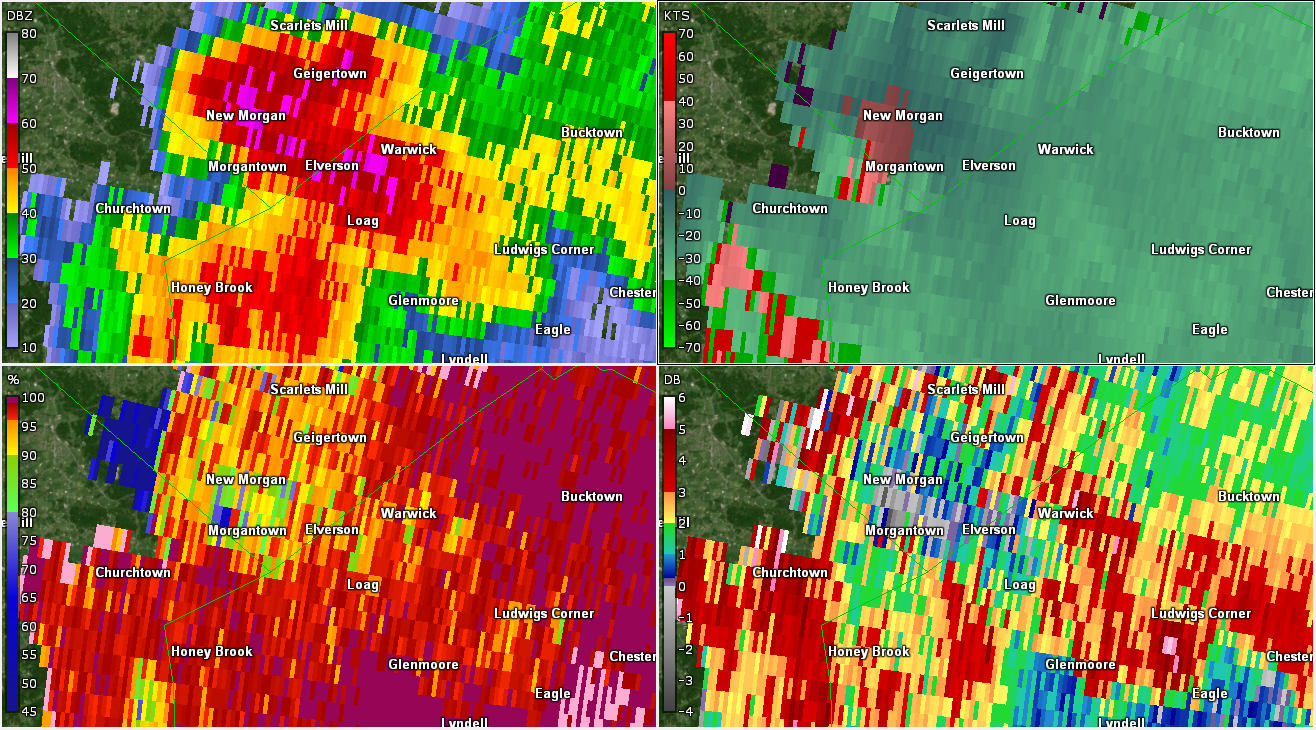 |
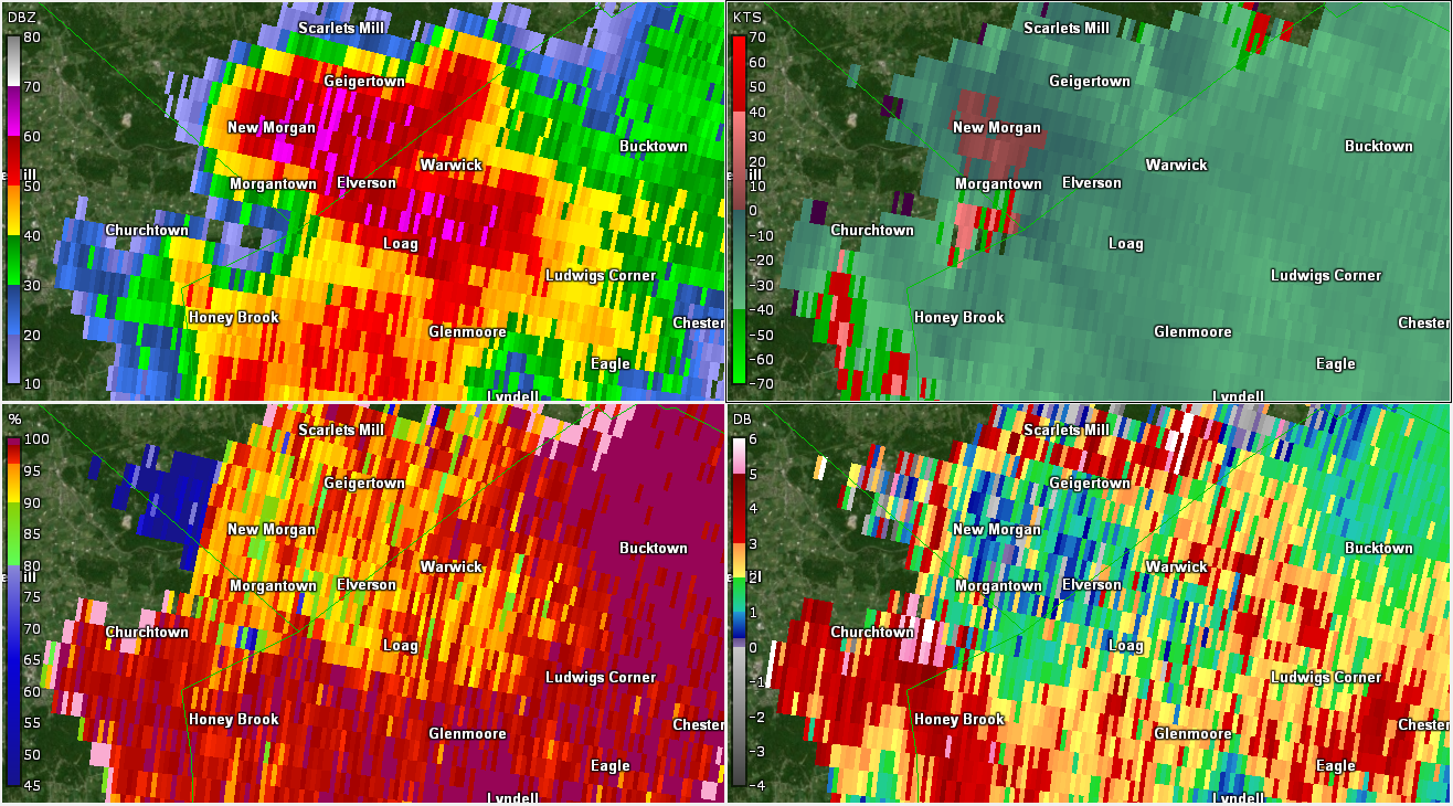
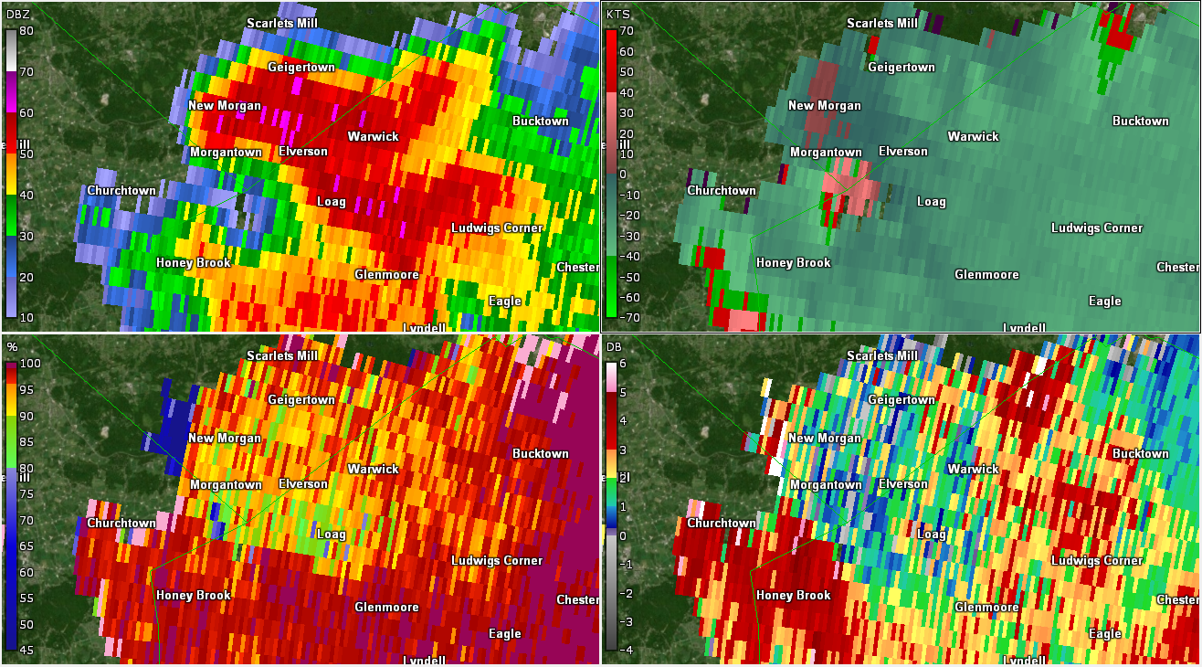
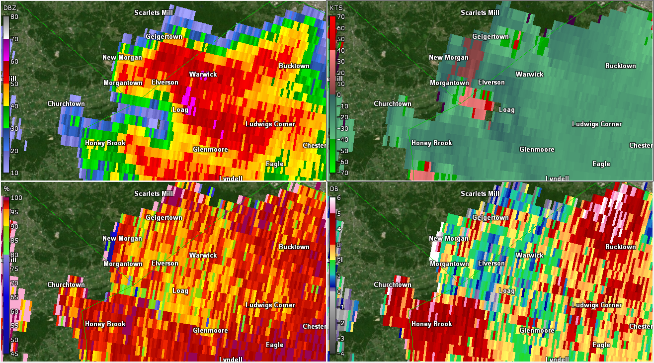
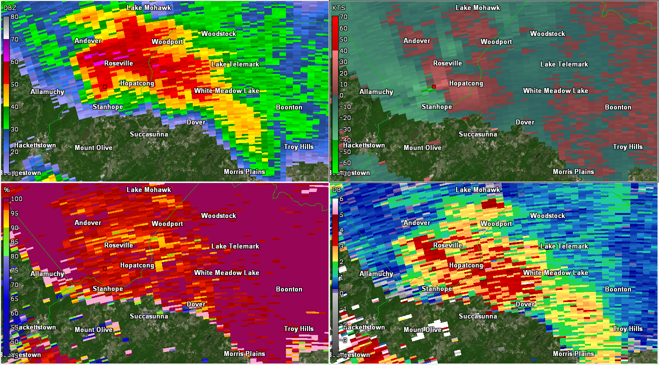
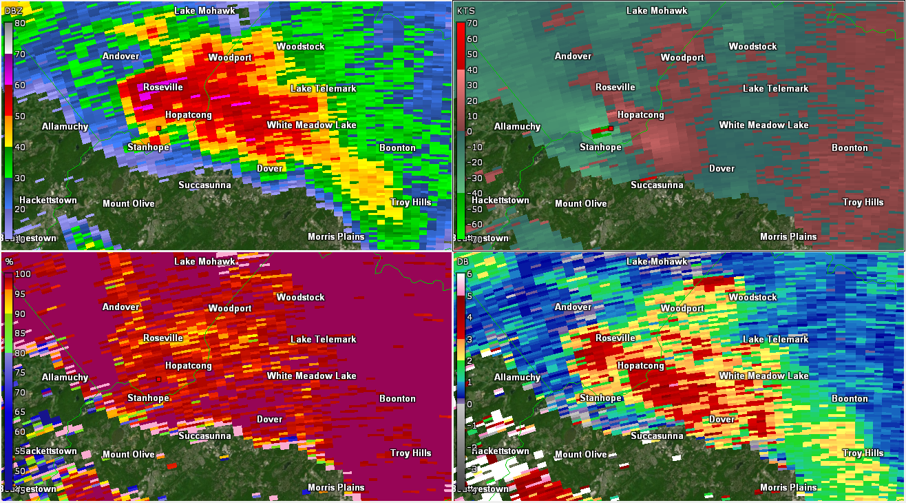
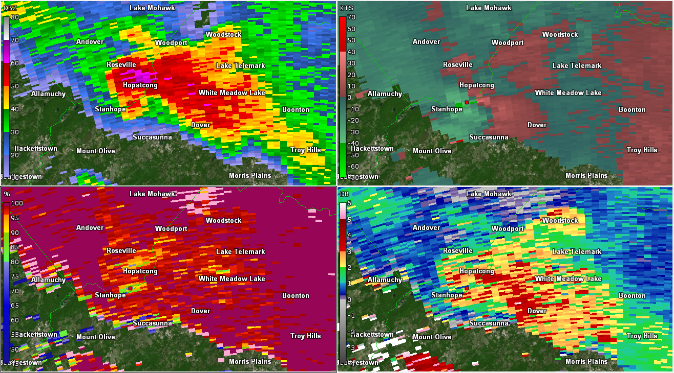
| Figure 1: KDIX radar reflectivity factor (top left), storm-relative motion (SRM; top right), correlation coefficient (CC; bottom left), and differential reflectivity (ZDR; bottom right) valid at 2148 UTC on 28 May 2019. A supercell was approaching the Morgantown area from the northwest, with strong mesocyclonic rotation (including velocity folding on SRM), a pronounced signal of hail (ZDR near zero and lowering of CC collocated with radar reflectivity factor greater than 60 dBZ between New Morgan and and Geigertown). A ZDR arc (very high ZDR on the south/east side of the supercell) is also present, further indicating strong low-level shear. Finally, a three-body scatter spike (TBSS) is present northwest of the supercell (CC < 70% on the far northwest portion of the plot). This image was valid about 3-4 minutes before tornadogenesis occurred just to the west of Morgantown. Very large hail (up to 2 inches in diameter) was reported with this storm around this time near New Morgan. | Figure 2: Same as Fig. 1, valid at 2151 UTC on 28 May 2019. The low-level rotation has tightened and increased. This is near the time of tornadogenesis near the Berks/Lancaster County border just west of Morgantown. The TBSS and hail core remain quite evident. | Figure 3: Same as Fig. 1, valid at 2153 UTC on 28 May 2019. The low-level rotation continued to tighten as it approached Morgantown. There is also an indication of a tornado debris signature (TDS; very low CC collocated with the strong rotation). |
 |
 |
 |
| Figure 4: Same as Fig. 1, valid at 2156 UTC on 28 May 2019. Gate-to-gate shear is near 100 kts at this point, strongly indicative of a tornado. There is still some evidence of a TDS as well (the CC < 70% just southeast of Morgantown). Note that the low CC to the south and somewhat farther from Morgantown is not the TDS. | Figure 5: Same as Fig. 1, valid at 2159 UTC on 28 May 2019. The low-level rotation remains quite strong, but the lowest CC is becoming displaced from the strongest low-level rotation. The tornado was still occurring at this time but was near dissipation. | Figure 6: Same as Fig. 1, valid at 2201 UTC on 28 May 2019. The tornado dissipated by this point as the circulation moved into Chester County, but low-level rotation remains quite strong. The hail core and TBSS have also weakened but have not disappeared. Large hail was likely occurring between Loag and Warwick at this point. |
 |
 |
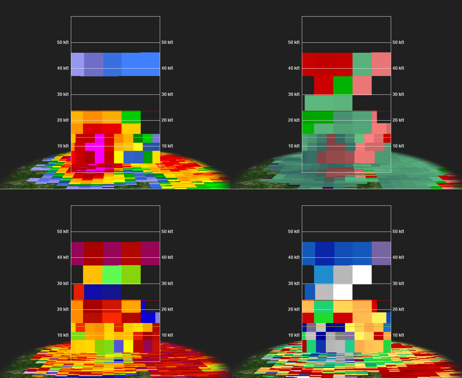
| Figure 7: Cross section of the Morgantown tornado valid at 2153 UTC on 28 May 2019 looking from the west toward the east, using KDIX base reflectivity (top left), storm-relative motion (top right), correlation coefficient (bottom left), and differential reflectivity (bottom right). The TDS is visible (low CC at the lowest elevation angle). Note that velocity folding is occurring with SRM, with the outbound readings on the right (south) side of the cross section actually an indication of very strong inbound velocities (confirming cyclonic rotation). A hail core is evident to the north (left) of the tornado (via low CC and near-zero ZDR collocated with 60+ dBZ radar reflectivity factor). | Figure 8: As in Fig. 7, except viewed from the south toward the north. The strongly sheared storm is indicated here by radar reflectivity factor leaning to the right (east) with height. A deep layer of convergence is evident (via the inbound -- green - velocities to the left/west of the outbound velocities -- red near and above the tornado. A mixture of rain and hail is occurring downstream (east) of the tornado, as indicated by 55-65 dBZ radar reflecitivity factor collocated with lower CC and near-zero ZDR up to 10 kft AGL. Again, the TDS is quite evident with the low CC at the surface (and is also implied by near-zero and sharply changing ZDR at the same location). |
Stanhope Tornado (GR2Analyst)
 |
 |
| Figure 9: Same as Fig. 1, valid at 0024 UTC on 29 May 2019. A marker is placed near the center of the strongest low-level cyclonic rotation as seen using SRM for what would become the Stanhope tornado (occurred around 8:30 pm). At this point, gate-to-gate shear exceeded 70 kts with the supercell storm, which also exhibited a broad ZDR arc and non-uniform beam filling to the northwest of the highest radar reflectivities with the storm (near Roseville). Large hail was reported with this storm as well. | Figure 10: Same as Fig. 1, valid at 0027 UTC on 29 May 2019. A marker is placed near the center of the strongest low-level cyclonic rotation as seen using SRM for what would become the Stanhope tornado (occurred around 8:30 pm). SRM has increased (as indicated by the presence of velocity folding). Tornadogenesis was imminent at this point. |
 |
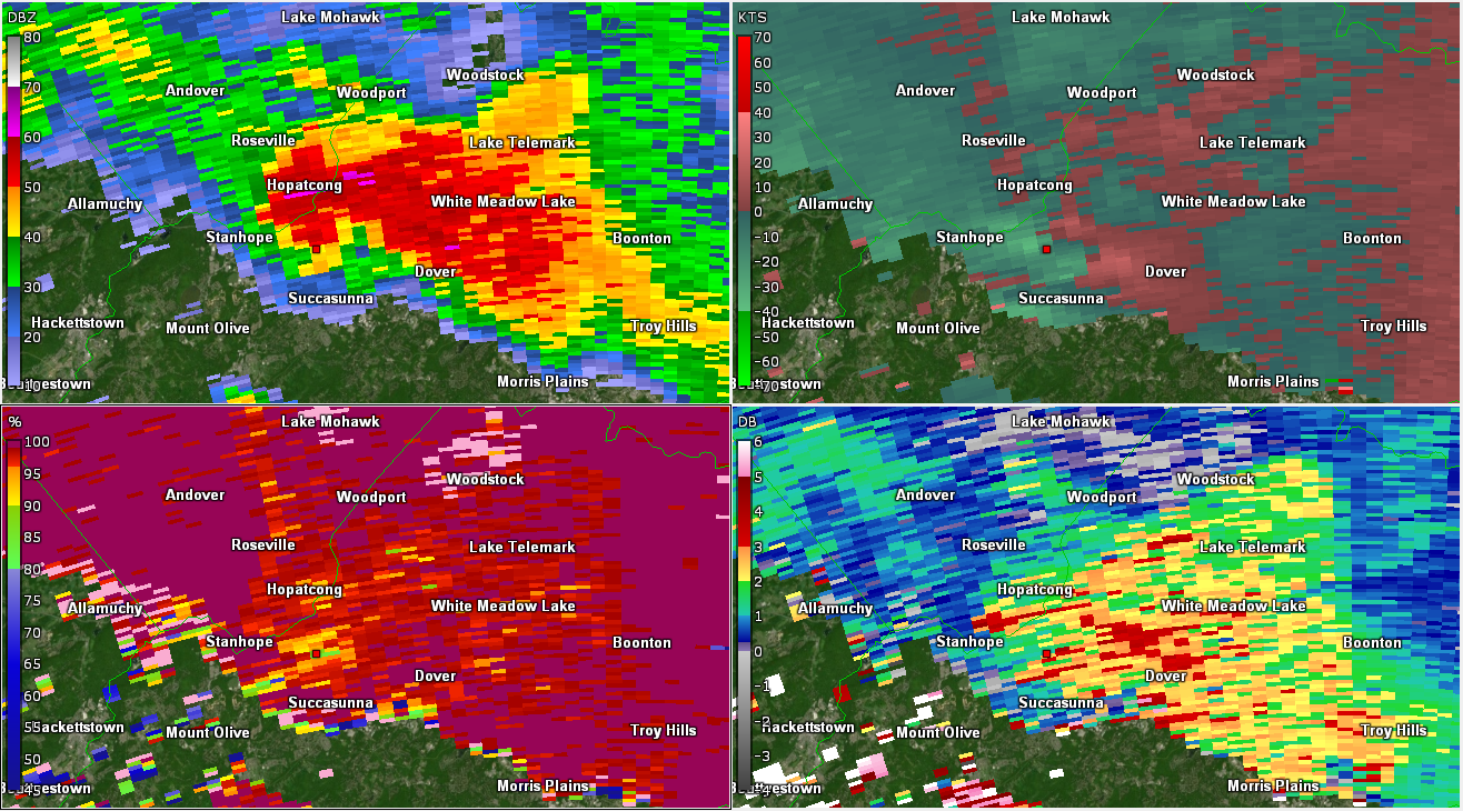 |
| Figure 11: Same as Fig. 1, valid at 0030 UTC on 29 May 2019. A TDS is now present (lowered CC; marker placed at this location), with tornado damage confirmed in this area. Gate-to-gate shear remained around 70-75 kts at this time. Notably, the radar reflectivity factor had increased just north of Hopatcong, with corresponding lower CC and near-zero ZDR. This is a strong indication of large to very large hail. This behavior was similar to the Morgantown supercell/tornado, in which the hail signatures became most pronounced just before and during the tornado. | Figure 12: Same as Fig. 1, valid at 0032 UTC on 29 May 2019. A marker is placed near the center of the remnant TDS. The low-level rotation had weakened by this point, and the tornado had likely dissipated. |
New Castle/Salem County Hail Swath (GR2Analyst)
 |
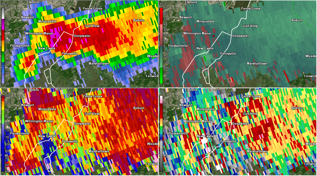 |
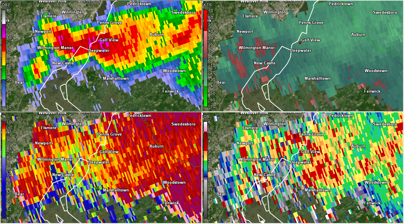
| Figure 13: Same as Fig. 1, valid at 2324 UTC on 28 May 2019. A supercell storm was affecting far northeast New Castle County in Delaware and western Salem County in New Jersey. The supercell exhibited classic characteristics of large hail, including a high-reflectivity forward-flank downdraft coincident with low ZDR and relatively low CC. Large hail reports from this area were strongly tied to these features. Hail reports were received near Carneys Point, NJ, at this time. | Figure 14: Same as Fig. 1, valid at 2327 UTC on 28 May 2019. The radar reflectivity factor becomes noticeably higher just east of Wilmington Manor, where damage from this storm was reported. |
 |
 |
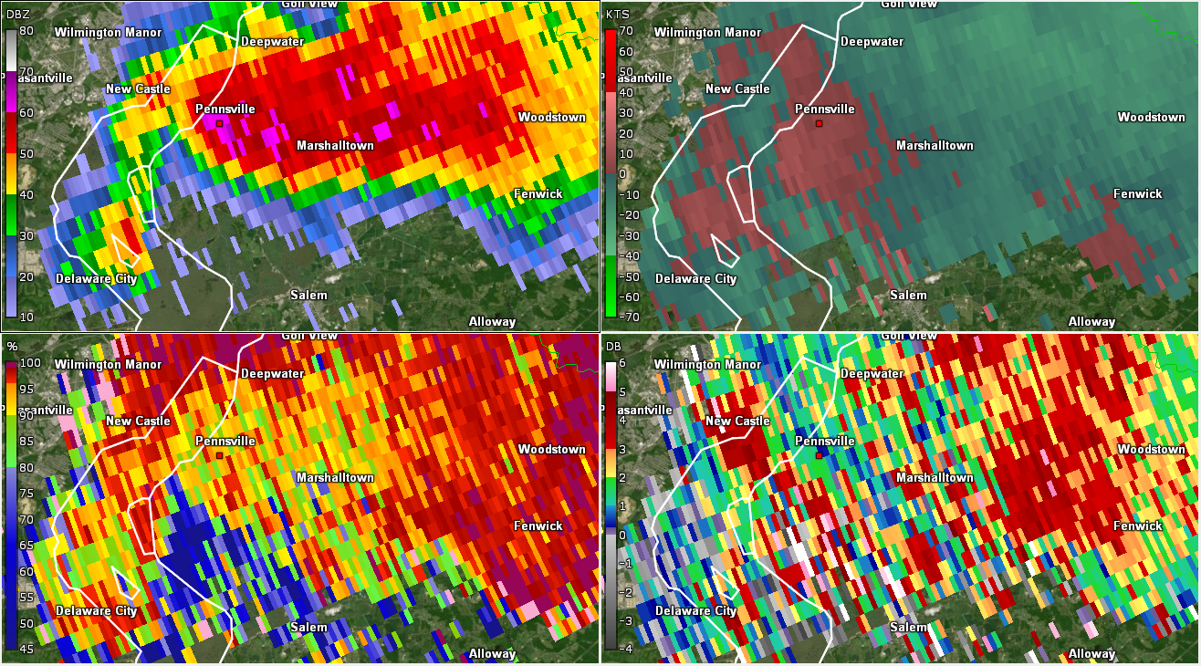
| Figure 15: Same as Fig. 1, valid at 2332 UTC on 28 May 2019. The strongest hail signatures were now located near Pennsville, NJ, where up to golf ball size hail was reported. | Figure 16: Same as Fig. 1, valid at 2342 UTC on 28 May 2019. Ping pong ball to golf ball size hail was reported in Salem, NJ, around this time. Note the TBSS to the southwest of Salem, as indicated by the very low CC. |
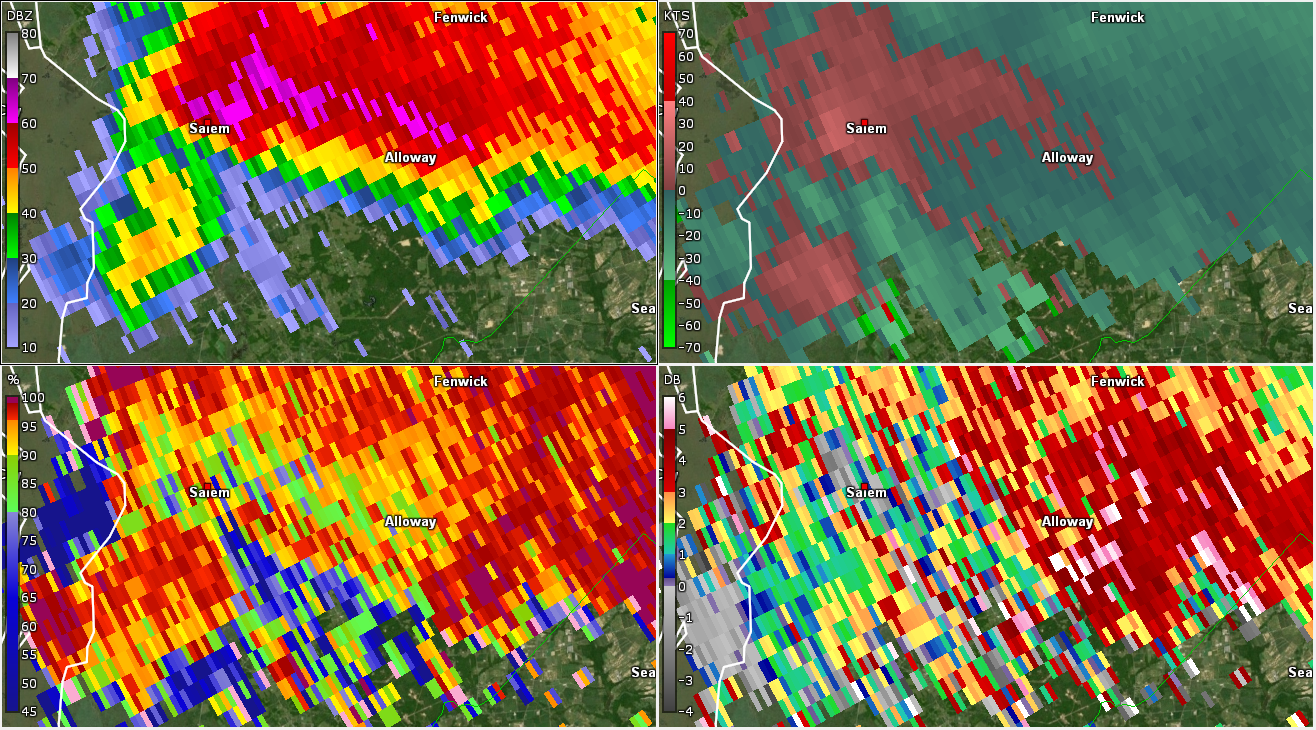
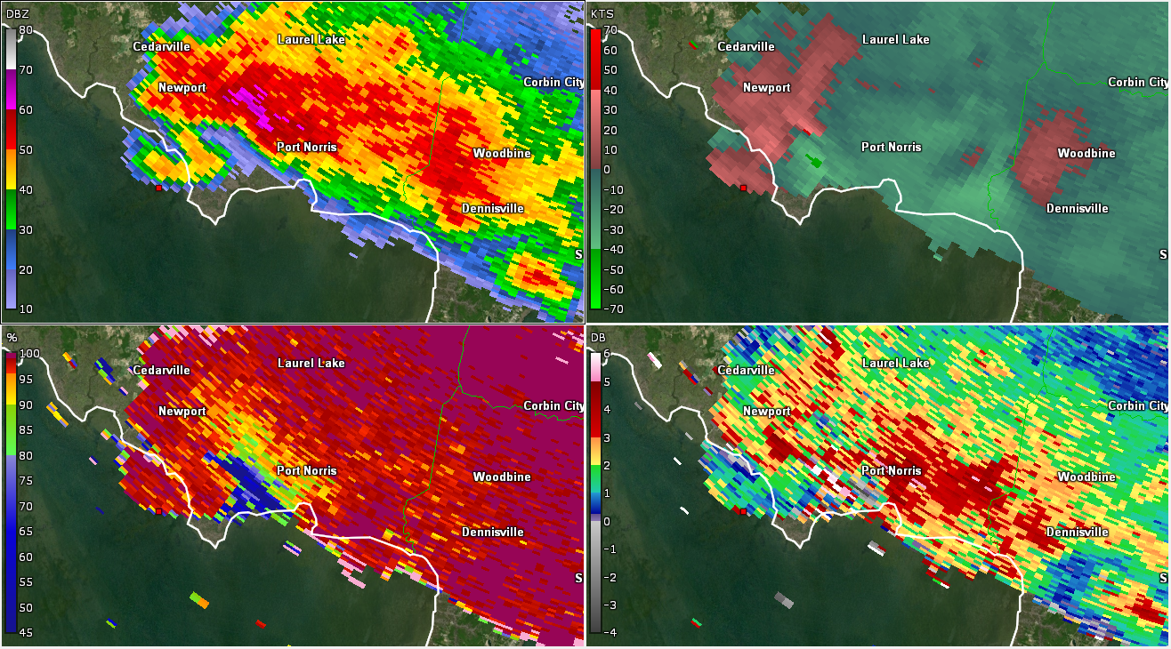
Delaware Bay Waterspout (GR2Analyst)
 |
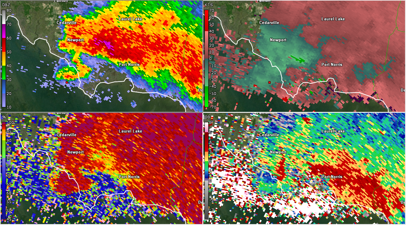 |
| Figure 17: Same as Fig. 1, valid at 0032 UTC on 29 May 2019. This was the approximate time a waterspout was reported off the coast of Cumberland County (indicated by the marker). The waterspout would have been along the rear-flank downdraft gust front of the supercell storm affecting Cumberland County at the time. The intense storm was producing large hail and wind damage in the Cedarville to Port Norris corridor at the time. The very low CC to the southwest of Port Norris (consistent with a TBSS), combined with the low ZDR and relatively low CC collocated with 65+ dBZ radar reflectivity factor between Newport and Port Norris, is a strong indication of severe hail. | Figure 18: Same as Fig. 1, except using KDOX valid at 0033 UTC on 29 May 2019. Note that many of the same features as seen on KDIX are present. Note also the high (>3 dB) ZDR near and to the southeast of Port Norris (indicative of a ZDR arc) and the lower CC/ZDR near the high radar reflectivity factors seen to the northwest of Port Norris (indicative of large hail). As seen in Fig. 15, the waterspout (approximated by the position of the marker) appears to be along the gust front of the rear-flank downdraft (at the interface of the hook echo of the supercell). |
Morgantown Tornado (Still under development...)
 |
|
|
 |
Stanhope Tornado (Still under development...)


 Coastal Flood
 Marine Forecasts
 Text Products
 Climate Information
 Skywarn
 Submit Storm Report
 Weather Event Archives
 Forecast Discussion
 Emergency Managers
 Briefing Page