
A heat wave over the Southwest will intensify this week, peaking and expanding into the Intermountain West and northern High Plains this weekend. Critical to extremely critical fire weather conditions are forecast from the Northwest and the northern Great Basin this weekend. Particularly Dangerous Situation Red Flag Warnings have been issued. Read More >
Overview
|
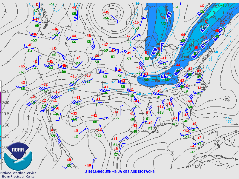
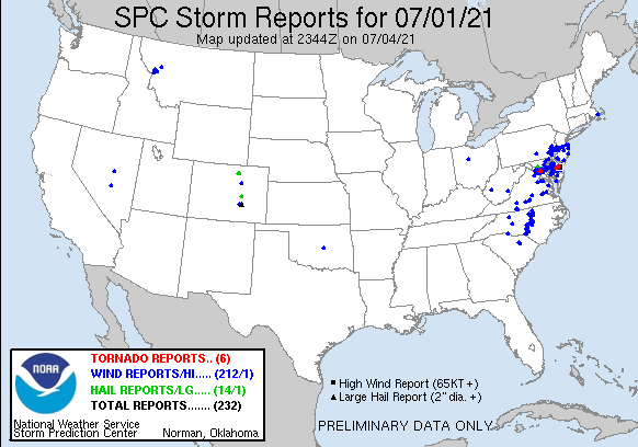
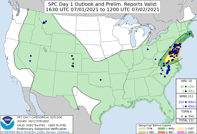
After a significant heatwave, a cold front approached the mid-Atlantic on July 1, 2021. A potent mid-level trough was also digging southward through southern Ontario and into the Great Lakes region, and a strong upper level jet streak was present downstream the trough axis, over the interior mid-Atlantic and northern New England. This strong upper level forcing combined with the approaching front and a lingering warm, moist air mass ahead of it caused widespread thunderstorm development on July 1. Storms occurred almost exclusively south of Interstate 78, in the environment of best instability. A number of storms became severe, taking the form of mainly linear and multi-cellular clusters but with some embedded supercellular characteristics. Straight line wind damage was the primary hazard, with a number of reports of downed trees and power outages due to winds. In addition, two confirmed EF-1 tornadoes occurred over southern Delaware. A remnant outflow boundary from earlier storms to the north, combined with sea/bay breezes in the area, likely caused a localized enhancement of low level wind shear and created a corridor of enhanced tornado potential. Another area of rotation over far eastern Pennsylvania and central New Jersey also prompted a couple of Tornado Warnings, but no evidence of tornadic damage was found in these areas. With the cold front remaining to the west, some storm activity continued into the overnight, but storm coverage and intensity gradually waned with the loss of daytime heating and the overturning of the atmosphere from earlier storms. |
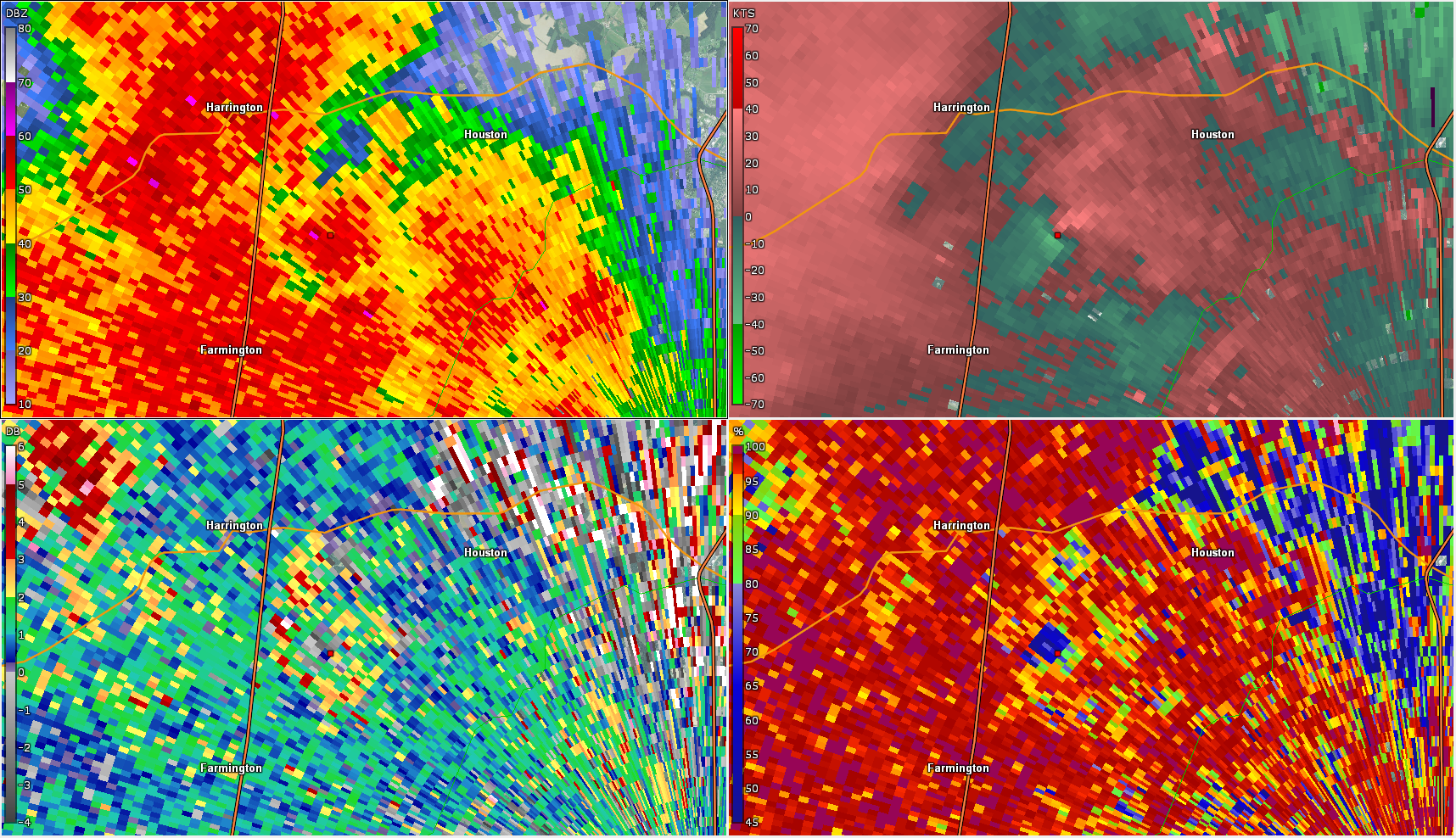
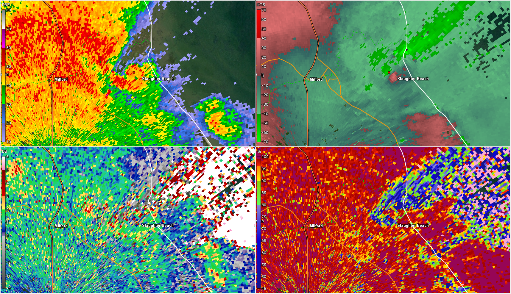
 KDOX radar loop from 4:43PM to 5:15PM on July 1, 2021, featuring the two EF-1 tornadoes in Delaware. Correlation coefficient and differential reflectivity panels show evidence of tornadic debris signatures. |
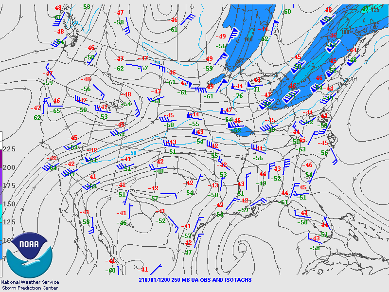
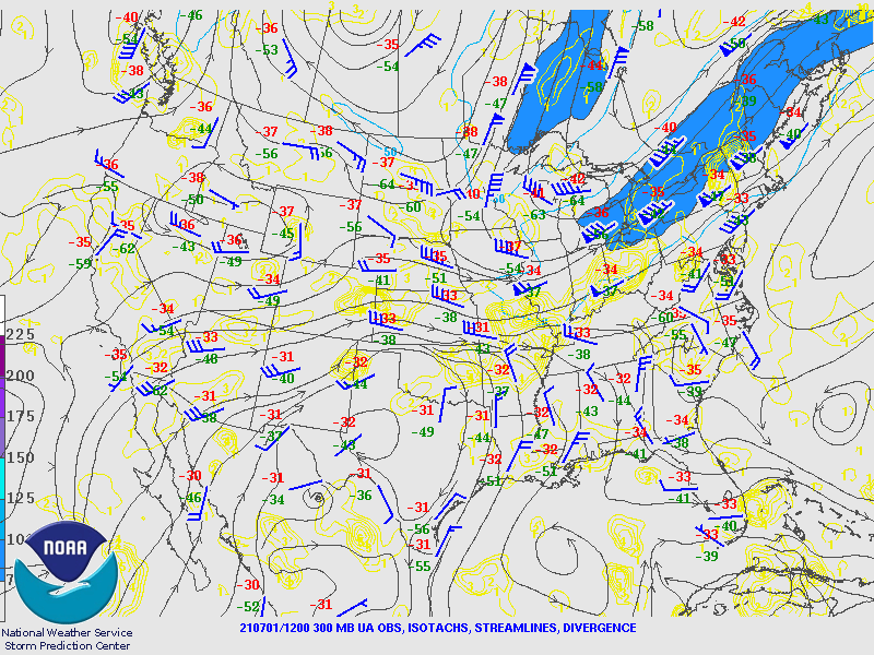
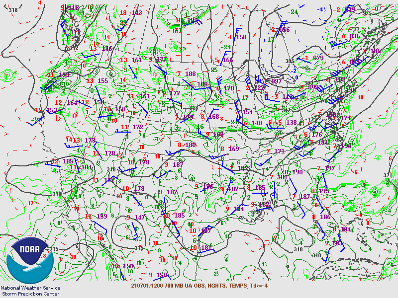
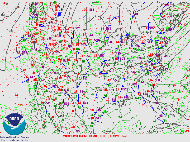
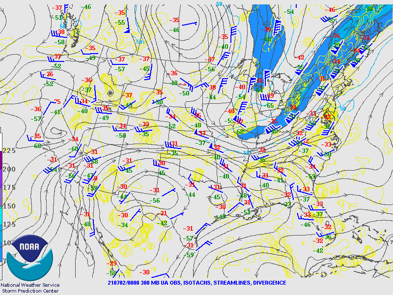
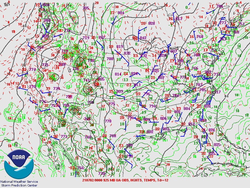
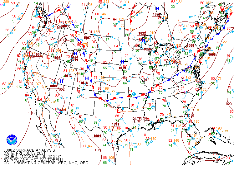
Synoptic Overview at 12z 1 Jul 2021 (courtesy of SPC)
 |
 |
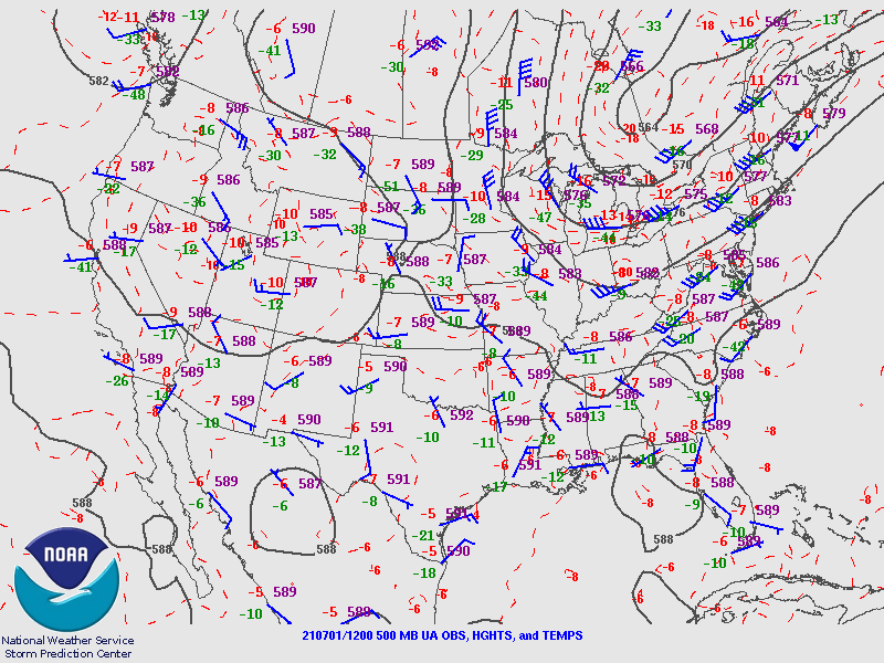 |
| Figure 1: 250-mb analysis | Figure 2: 300-mb analysis | Figure 3: 500-mb analysis |
 |
 |
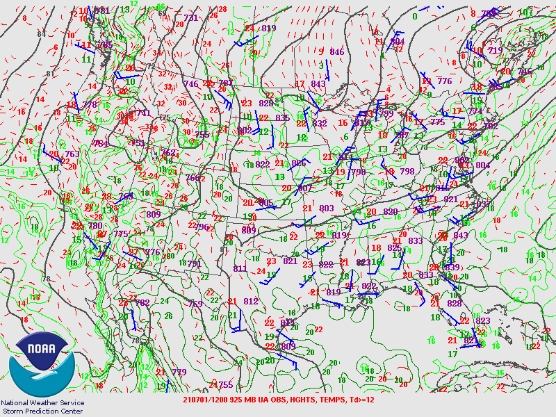 |
| Figure 4: 700-mb analysis | Figure 5: 850-mb analysis | Figure 6: 925-mb analysis |
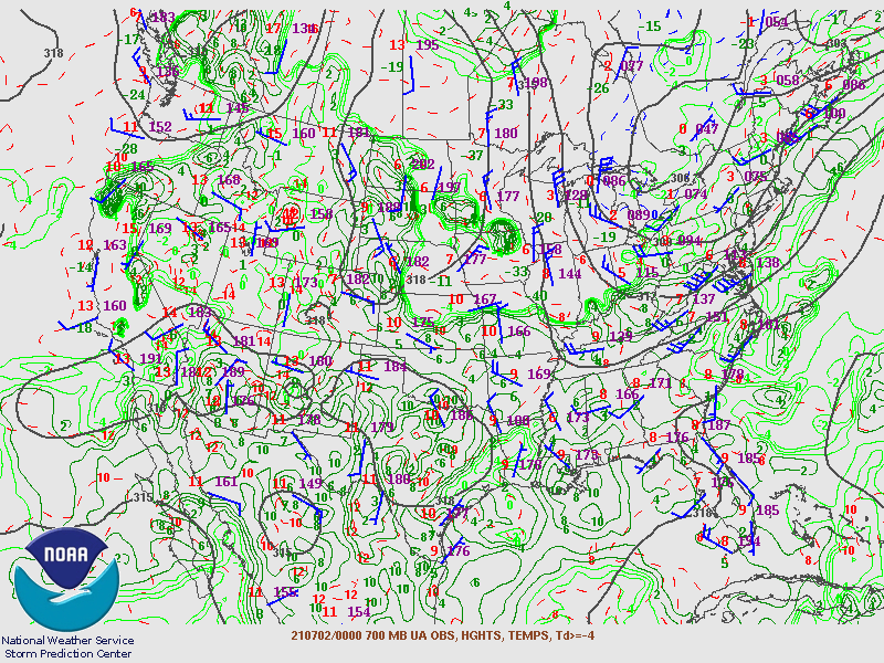
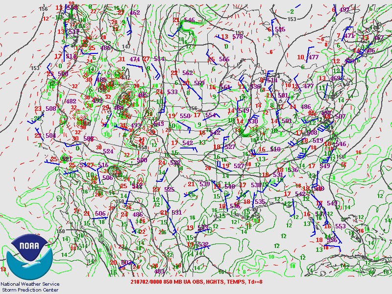
Synoptic Overview at 00z 2 Jul 2021 (courtesy of SPC)
 |
 |
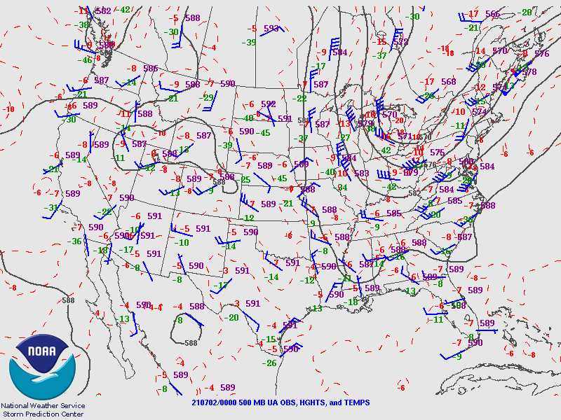 |
| Figure 7: 250-mb analysis | Figure 8: 300-mb analysis | Figure 9: 500-mb analysis |
 |
 |
 |
| Figure 10: 700-mb analysis | Figure 11: 850-mb analysis | Figure 12: 925-mb analysis |
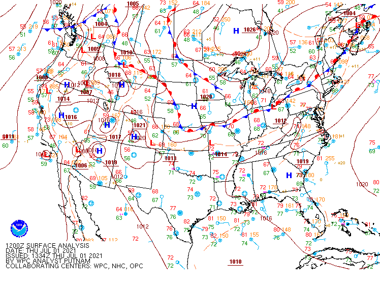
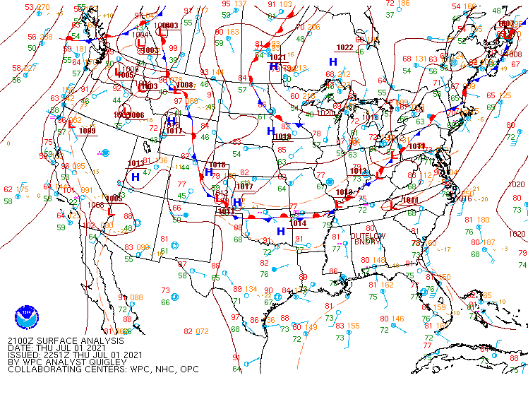
Surface Maps (courtesy of WPC)
 |
 |
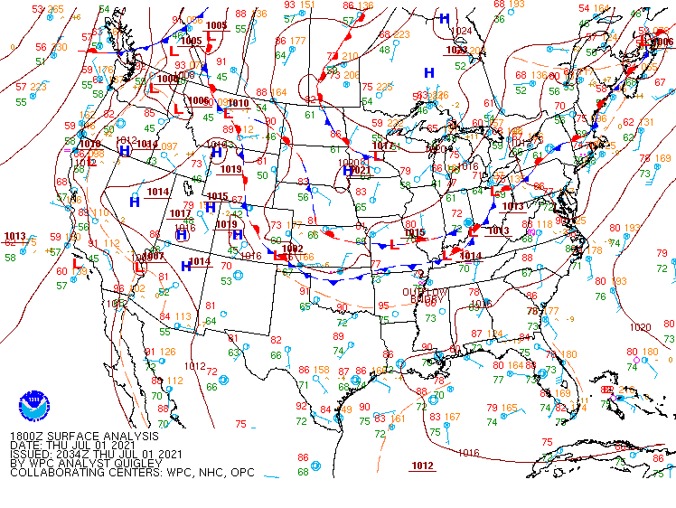 |
| Figure 13: 12z surface map | Figure 14: 15z surface map | Figure 15: 18z surface map |
 |
 |
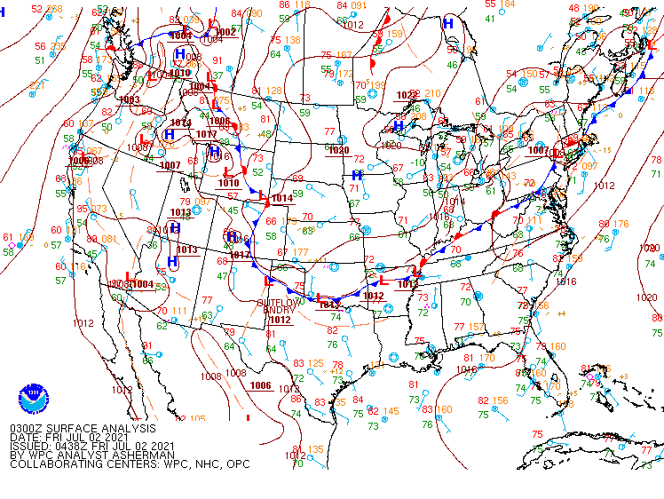 |
| Figure 16: 21z surface map | Figure 17: 00z surface map | Figure 18: 03z surface map |
 |
 |
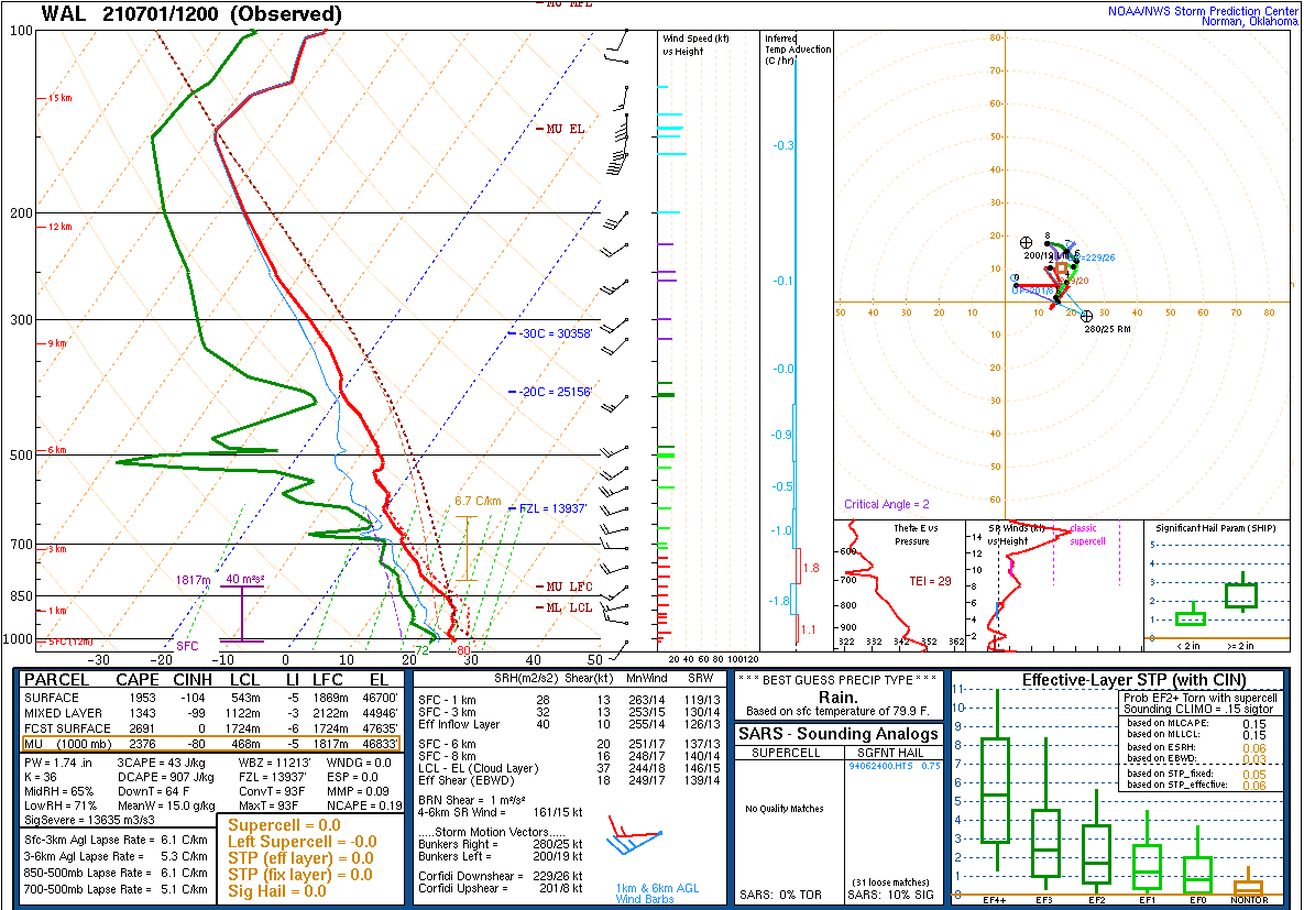 |
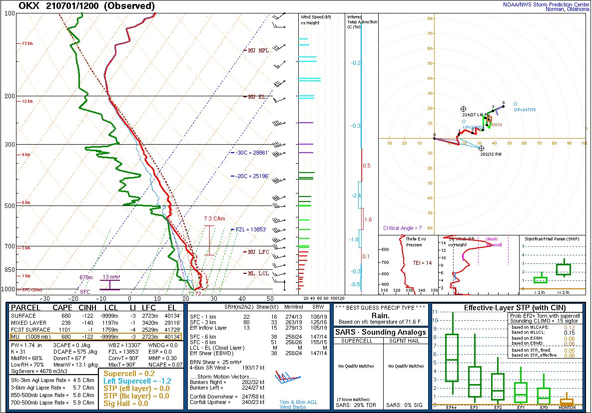
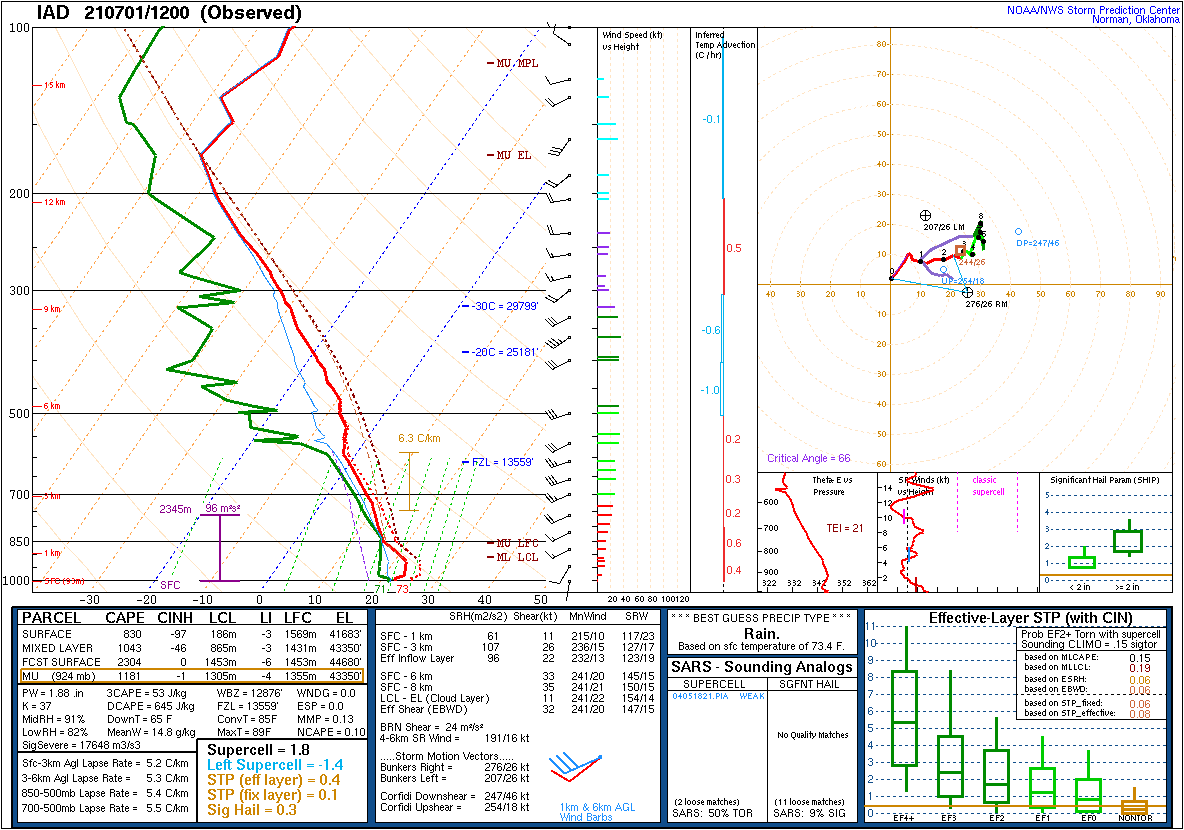
| Figure 19: 12z Long Island, NY sounding | Figure 20: 12z Sterling, VA sounding | Figure 21: 12z Wallops Island, VA sounding |
 |
 |
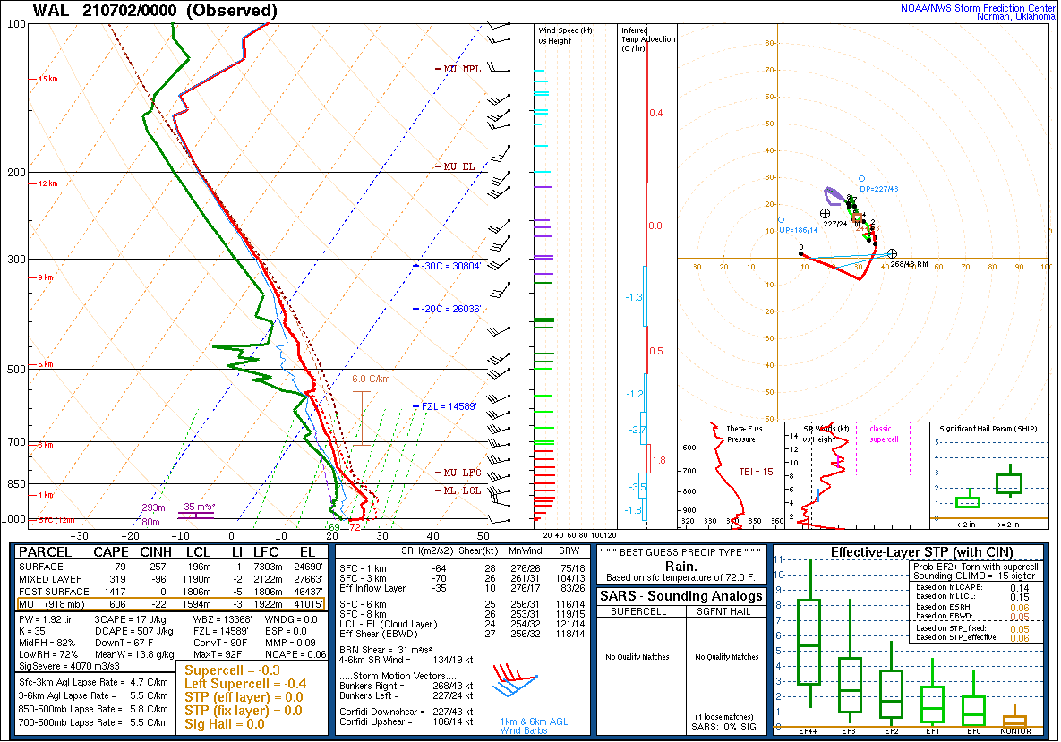 |
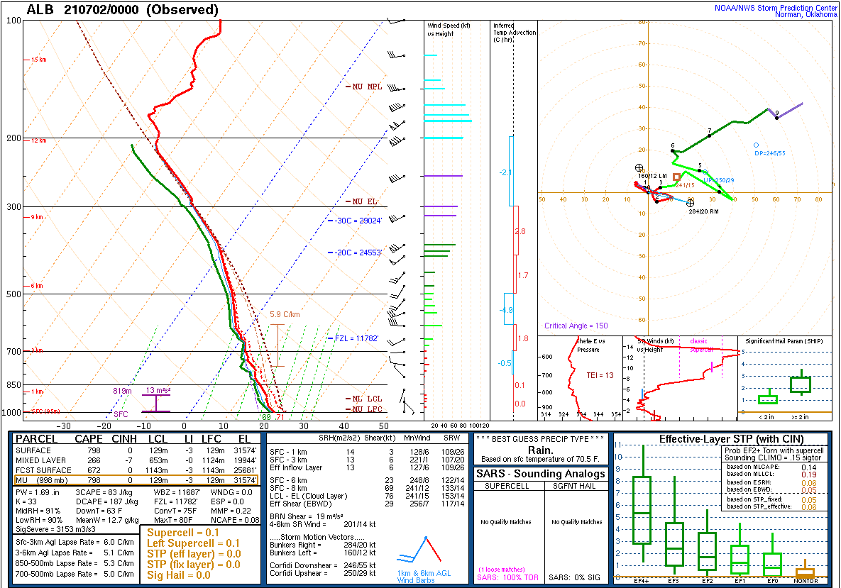
| Figure 19: 12z Albany, NY sounding (Long Island was unavailable) | Figure 20: 12z Sterling, VA sounding | Figure 21: 12z Wallops Island, VA sounding |
 |
 |
 |
| Figure 1: National Preliminary Reports 12z 31 Mar 2022 to 12z 1 Apr 2022 | Figure 2: Zoomed Preliminary Reports for the same period. | Preliminary reports vs 1630z Day 1 SPC outlook. |
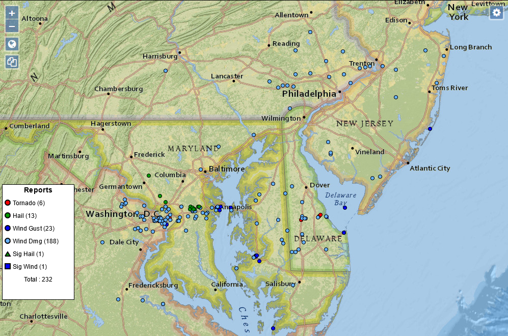
Click here for a county warning area based plot of local storm reports and warnings/advisories issued for the 1 Jul 2021 event.
PRELIMINARY LOCAL STORM REPORT...SUMMARY
NATIONAL WEATHER SERVICE MOUNT HOLLY NJ
503 AM EDT FRI JUL 2 2021

..TIME...   ...EVENT...      ...CITY LOCATION...     ...LAT.LON...
..DATE...   ....MAG....      ..COUNTY LOCATION..ST.. ...SOURCE....
            ..REMARKS..

0313 PM     TSTM WND DMG     4 NNE WEST SADSBURY TWP 40.04N 75.92W
07/01/2021                   CHESTER            PA   COUNTY OFFICIAL

            DOWNED TREE ON LAMMEY ROAD. TIME ESTIMATED
            FROM RADAR.

0321 PM     TSTM WND DMG     2 NNW GERYVILLE         40.45N 75.48W
07/01/2021                   LEHIGH             PA   UTILITY COMPANY

            DOWNED WIRES NEAR ELM ROAD. TIME ESTIMATED
            FROM RADAR.

0321 PM     TSTM WND DMG     2 WNW CALN TWP          40.01N 75.78W
07/01/2021                   CHESTER            PA   COUNTY OFFICIAL

            DOWNED TREE ON FISHERVILLE ROAD. TIME
            ESTIMATED FROM RADAR.

0323 PM     TSTM WND DMG     2 SW GILBERTSVILLE      40.30N 75.64W
07/01/2021                   MONTGOMERY         PA   PUBLIC

            MPING REPORT OF DOWNED TREE LIMBS AND POWER
            LINES NEAR ROUTE 100. TIME ESTIMATED FROM
            RADAR.

0327 PM     TSTM WND DMG     1 NE THORNDALE          40.01N 75.73W
07/01/2021                   CHESTER            PA   COUNTY OFFICIAL

            DOWNED TREE ON BEAVER RUN ROAD. TIME
            ESTIMATED FROM RADAR.

0331 PM     TSTM WND DMG     1 W CHESTER SPRINGS     40.10N 75.64W
07/01/2021                   CHESTER            PA   UTILITY COMPANY

            DOWNED WIRES NEAR HORSESHOE TRAIL. TIME
            ESTIMATED FROM RADAR.

0351 PM     TSTM WND DMG     1 WNW VALLEY FORGE      40.11N 75.48W
07/01/2021                   CHESTER            PA   UTILITY COMPANY

            SEVERAL REPORTS OF DOWNED TREE LIMBS AND
            WIRES NEAR VALLEY FORGE AND PHOENIXVILLE.
            TIME ESTIMATED FROM RADAR.

0400 PM     TSTM WND DMG     2 SSW STEVENSVILLE      38.97N 76.33W
07/01/2021                   QUEEN ANNE'S       MD   DEPT OF HIGHWAYS

            TREES AND UTILITY WIRES DOWN WITH DEBRIS ON
            THE ROADWAY ALONG MARYLAND ROUTE 8 SOUTH OF
            KENT MANOR DRIVE.

0412 PM     TSTM WND DMG     1 E CONSHOHOCKEN        40.08N 75.28W
07/01/2021                   MONTGOMERY         PA   COUNTY OFFICIAL

            DOWNED TREE LIMBS ON JOSHUA ROAD NEAR CEDAR
            GROVE ROAD. TIME ESTIMATED FROM RADAR.

0419 PM     TSTM WND DMG     2 SSE TEMPLEVILLE       39.11N 75.75W
07/01/2021                   CAROLINE           MD   UTILITY COMPANY

            SEVERAL REPORTS OF DOWNED TREE LIMBS AND
            WIRES BETWEEN MARYDEL AND HARTLY. TIME
            ESTIMATED FROM RADAR.

0421 PM     TSTM WND DMG     FEDERALSBURG            38.69N 75.77W
07/01/2021                   CAROLINE           MD   UTILITY COMPANY

            SEVERAL REPORTS OF POWER LINES DOWN AND
            NUMEROUS POWER OUTAGES IN THE FEDERALSBURG
            AREA. TIME ESTIMATED FROM RADAR.

0424 PM     TSTM WND DMG     CENTREVILLE             39.05N 76.07W
07/01/2021                   QUEEN ANNE'S       MD   UTILITY COMPANY

            SEVERAL REPORTS OF WIRES DOWN NEAR
            CENTREVILLE. TIME ESTIMATED FROM RADAR.

0426 PM     TSTM WND DMG     1 E HARTLY              39.17N 75.68W
07/01/2021                   KENT               DE   UTILITY COMPANY

            DOWNED TREE LIMBS AND WIRES EAST OF HARTLY.
            TIME ESTIMATED FROM RADAR.

0430 PM     TSTM WND DMG     1 NE JENKINTOWN         40.10N 75.12W
07/01/2021                   MONTGOMERY         PA   COUNTY OFFICIAL

            DOWNED TREE ON WIRES NEAR THE INTERSECTION
            OF WASHINGTON LANE AND PEPPER ROAD. TIME
            ESTIMATED FROM RADAR.

0430 PM     TSTM WND DMG     2 NNW FEDERALSBURG      38.72N 75.79W
07/01/2021                   CAROLINE           MD   DEPT OF HIGHWAYS

            TREES AND UTILITY WIRES DOWN WITH DEBRIS ON
            THE ROADWAY ALONG MARYLAND ROUTE 313 NEAR
            OLD DENTON ROAD.

0435 PM     TSTM WND DMG     2 SW STARKEY CORNER     39.10N 76.03W
07/01/2021                   QUEEN ANNE'S       MD   DEPT OF HIGHWAYS

            TREES AND UTILITY WIRES DOWN WITH DEBRIS ON
            THE ROADWAY ALONG MARYLAND ROUTE 213 NEAR
            HATCHETT ROAD.

0435 PM     TSTM WND DMG     DENTON                  38.89N 75.83W
07/01/2021                   CAROLINE           MD   UTILITY COMPANY

            DOWNED WIRES IN THE DENTON AREA. TIME
            ESTIMATED FROM RADAR.

0435 PM     TSTM WND DMG     2 N SMITHVILLE          38.80N 75.73W
07/01/2021                   CAROLINE           MD   DEPT OF HIGHWAYS

            TREES AND UTILITY LINES DOWN WITH DEBRIS ON
            THE ROADWAY ALONG MARYLAND ROUTE 404 AND
            BREEDING ROAD.

0442 PM     TSTM WND DMG     4 WSW SEAFORD           38.62N 75.68W
07/01/2021                   SUSSEX             DE   UTILITY COMPANY

            DOWNED TREES AND POWER LINES NEAR WOODPECKER
            ROAD. TIME ESTIMATED FROM RADAR.

0442 PM     TSTM WND DMG     2 SSW WOODSIDE          39.04N 75.57W
07/01/2021                   KENT               DE   UTILITY COMPANY

            SEVERAL REPORTS OF DOWNED TREE LIMBS AND
            WIRES NORTH OF FELTON. TIME ESTIMATED FROM
            RADAR.

0445 PM     FLOOD            1 SW CAMDEN             39.11N 75.55W
07/01/2021                   KENT               DE   DEPT OF HIGHWAYS

            FLOODING AT SOUTH MAIN STREET AND SOUTH
            STREET.

0448 PM     TSTM WND DMG     TACONY                  40.03N 75.05W
07/01/2021                   PHILADELPHIA       PA   PUBLIC

            MPING REPORT OF WIND DAMAGE NEAR JACKSON
            STREET. TIME ESTIMATED FROM RADAR.

0450 PM     TSTM WND DMG     1 NE FEASTERVILLE-TREVO 40.15N 74.95W
07/01/2021                   BUCKS              PA   DEPT OF HIGHWAYS

            TREE DOWN ON U.S. ROUTE 1.

0450 PM     TSTM WND DMG     2 SW SEAFORD            38.62N 75.64W
07/01/2021                   SUSSEX             DE   UTILITY COMPANY

            DOWNED TREE LIMBS AND WIRES NEAR CRAIGS MILL
            ROAD AND WOODLAND ROAD. TIME ESTIMATED FROM
            RADAR.

0452 PM     TSTM WND DMG     HARRINGTON              38.92N 75.57W
07/01/2021                   KENT               DE   DEPT OF HIGHWAYS

            TREES AND UTILITY LINES DOWN WITH DEBRIS IN
            THE ROADWAY.

0452 PM     TSTM WND DMG     2 NNE FARMINGTON        38.90N 75.57W
07/01/2021                   KENT               DE   EMERGENCY MNGR

            TREES DOWN AND VEHICLES BLOWN OFF THE ROAD
            ALONG U.S ROUTE 13 AROUND TOWER HILL ROAD.

0453 PM     TSTM WND DMG     LEVITTOWN               40.16N 74.89W
07/01/2021                   BUCKS              PA   UTILITY COMPANY

            SEVERAL REPORTS OF DOWNED TREE LIMBS AND
            WIRES IN LEVITTOWN. TIME ESTIMATED FROM
            RADAR.

0453 PM     TSTM WND DMG     3 NE BRIDGEVILLE        38.77N 75.57W
07/01/2021                   SUSSEX             DE   UTILITY COMPANY

            SEVERAL REPORTS OF DOWNED TREES AND WIRES
            NORTHEAST OF BRIDGEVILLE. TIME ESTIMATED
            FROM RADAR.

0453 PM     TSTM WND DMG     SEAFORD                 38.64N 75.61W
07/01/2021                   SUSSEX             DE   FIRE DEPT/RESCUE

            DOWNED WIRES ON HALL STREET, ALDER LANE, AND
            NEAR THE INTERSECTION OF NEALS SCHOOL ROAD
            AND BOYCE ROAD IN SEAFORD. TIME ESTIMATED
            FROM RADAR.

0458 PM     TSTM WND DMG     2 SW HOUSTON            38.90N 75.53W
07/01/2021                   KENT               DE   UTILITY COMPANY

            DOWNED TREES AND WIRES NEAR THISTLEWOOD
            ROAD. TIME ESTIMATED FROM RADAR.

0459 PM     TSTM WND DMG     1 SE FAIRLESS HILLS     40.17N 74.84W
07/01/2021                   BUCKS              PA   UTILITY COMPANY

            SEVERAL REPORTS OF DOWNED POWER LINES NEAR
            FAIRLESS HILLS. TIME ESTIMATED FROM RADAR.

0500 PM     TSTM WND DMG     2 WSW HOUSTON           38.90N 75.54W
07/01/2021                   KENT               DE   PUBLIC

            ROOF DAMAGE TO A MOBILE HOME ON HUNTING
            QUARTER ROAD NEAR WILLIAMSVILLE, DE. TIME
            ESTIMATED FROM RADAR. SOCIAL MEDIA REPORT.

0502 PM     TORNADO          3 ENE MILFORD           38.93N 75.37W
07/01/2021                   SUSSEX             DE   TRAINED SPOTTER

            SIGNIFICANT TREE DAMAGE WITH SOME TREES INTO
            HOUSES.

0503 PM     TSTM WND DMG     2 E MILFORD             38.91N 75.40W
07/01/2021                   SUSSEX             DE   TRAINED SPOTTER

            SEVERAL LARGE TREES DOWNED. TIME ESTIMATED
            FROM RADAR.

0505 PM     TSTM WND GST     1 E MILFORD             38.91N 75.42W
07/01/2021  M46 MPH          SUSSEX             DE   MESONET


0506 PM     TSTM WND DMG     3 ESE ALLOWAY           39.54N 75.29W
07/01/2021                   SALEM              NJ   UTILITY COMPANY

            DOWNED POWER LINES NEAR ALLOWAY FRIESBURG
            ROAD. TIME ESTIMATED FROM RADAR.

0509 PM     TSTM WND GST     6 SSE BIG STONE BEACH   38.91N 75.30W
07/01/2021  M80 MPH          SUSSEX             DE   PUBLIC

            PERSONAL WEATHER STATION KDEMILFO30. GUST
            WAS MEASURED IN VERY CLOSE PROXIMITY TO A
            LIKELY TORNADO.

0516 PM     TSTM WND GST     LEWES                   38.78N 75.13W
07/01/2021  M56 MPH          SUSSEX             DE   MESONET

            WEATHERFLOW.

0518 PM     TSTM WND GST     1 ENE LEWES             38.78N 75.12W
07/01/2021  M64 MPH          SUSSEX             DE   MESONET

            NOS GAUGE LWSD1.

0519 PM     TSTM WND DMG     2 WSW YARDVILLE         40.17N 74.70W
07/01/2021                   BURLINGTON         NJ   FIRE DEPT/RESCUE

            DOWNED WIRES ON GRAND AVENUE. TIME ESTIMATED
            FROM RADAR.

0519 PM     TSTM WND DMG     STOCKLEY                38.64N 75.31W
07/01/2021                   SUSSEX             DE   UTILITY COMPANY

            DOWNED POWER POLES AND WIRES NEAR MORRIS
            MILL ROAD. TIME ESTIMATED FROM RADAR.

0524 PM     MARINE TSTM WIND BRANDYWINE SHOAL LIGHT  38.99N 75.11W
07/01/2021  M68 MPH          ANZ431             NJ   OTHER FEDERAL

            NOS GAUGE BRND1.

0524 PM     TSTM WND GST     1 ENE LEWES             38.78N 75.12W
07/01/2021  M61 MPH          SUSSEX             DE   MESONET

            NOS GAUGE LWSD1.

0530 PM     MARINE TSTM WIND 1 SSW NORTH CAPE MAY    38.97N 74.96W
07/01/2021  M52 MPH          CAPE MAY           NJ   MESONET

            NOS GAUGE CMAN4.

0530 PM     MARINE TSTM WIND 1 NE LEWES              38.78N 75.12W
07/01/2021  M50 MPH          ANZ431             DE   MESONET

            CAPE HENLOPEN WEATHERFLOW SITE.

0532 PM     TSTM WND GST     CAPE MAY                38.94N 74.91W
07/01/2021  M45 MPH          CAPE MAY           NJ   MESONET

            WEATHERFLOW.

0535 PM     TSTM WND DMG     WOODBINE                39.24N 74.81W
07/01/2021                   CAPE MAY           NJ   UTILITY COMPANY

            SEVERAL REPORTS OF DOWNED POWER LINES IN THE
            AREA. TIME ESTIMATED FROM RADAR.

0538 PM     MARINE TSTM WIND INDIAN BEACH            38.68N 75.08W
07/01/2021  M45 MPH          ANZ455             DE   MESONET

            WEATHERFLOW SITE XDEW.

0549 PM     MARINE TSTM WIND 1 NNW SEA ISLE CITY     39.18N 74.70W
07/01/2021  M50 MPH          ANZ453             NJ   MESONET

            WEATHERFLOW GAUGE XLUD.

0555 PM     TSTM WND GST     2 SE WOODBINE           39.22N 74.79W
07/01/2021  M46 MPH          CAPE MAY           NJ   MESONET


0555 PM     TSTM WND GST     2 ENE DENNISVILLE       39.20N 74.78W
07/01/2021  M48 MPH          CAPE MAY           NJ   MESONET


0602 PM     TSTM WND DMG     1 S MARLBORO            40.30N 74.24W
07/01/2021                   MONMOUTH           NJ   UTILITY COMPANY

            A FEW REPORTS OF DOWNED TREES AND WIRES NEAR
            DUTCH LANE ROAD AND AUSTEN COURT. TIME
            ESTIMATED FROM RADAR.

0605 PM     TSTM WND GST     CAPE HENLOPEN BEACH     38.80N 75.09W
07/01/2021  M49 MPH          SUSSEX             DE   MESONET


0620 PM     TSTM WND DMG     2 ESE LEISURE VILLAGE E 40.03N 74.12W
07/01/2021                   OCEAN              NJ   UTILITY COMPANY

            SEVERAL REPORTS OF DOWNED WIRES IN BRICK
            TOWNSHIP AND THE LEISURE VILLAGE EAST AREA.
            TIME ESTIMATED FROM RADAR.

0625 PM     TSTM WND DMG     2 NNW WANAMASSA         40.25N 74.04W
07/01/2021                   MONMOUTH           NJ   UTILITY COMPANY

            SEVERAL REPORTS OF DOWNED POWER LINES IN THE
            WANAMASSA AND DEAL AREAS. TIME ESTIMATED
            FROM RADAR.

0630 PM     MARINE TSTM WIND 1 WSW LAVALLETTE        39.96N 74.09W
07/01/2021  M39 MPH          ANZ451             NJ   PUBLIC

            MEASURED BY A TEMPEST WEATHER STATION NEAR
            PERSHING BLVD.

0632 PM     TSTM WND DMG     4 SE BRIDGEVILLE        38.70N 75.55W
07/01/2021                   SUSSEX             DE   UTILITY COMPANY

            SEVERAL REPORTS OF TREES AND WIRES DOWN NEAR
            ROUTE 18 SOUTHEAST OF BRIDGEVILLE. TIME
            ESTIMATED FROM RADAR.

0640 PM     FLOOD            SPRING LAKE HEIGHTS     40.15N 74.04W
07/01/2021                   MONMOUTH           NJ   DEPT OF HIGHWAYS

            FLOODING ALONG NEW JERSEY ROUTE 71 AT WARREN
            AVENUE.

0642 PM     MARINE TSTM WIND 2 E WARETOWN            39.79N 74.17W
07/01/2021  M40 MPH          ANZ451             NJ   MESONET

            KITE ISLAND WEATHERFLOW GAUGE.

0644 PM     TSTM WND GST     SURF CITY               39.66N 74.17W
07/01/2021  M47 MPH          OCEAN              NJ   MESONET

            WEATHERFLOW.

0644 PM     MARINE TSTM WIND 2 WNW SHIP BOTTOM       39.66N 74.21W
07/01/2021  M54 MPH          ANZ451             NJ   MESONET

            WEATHERFLOW GAUGE XLBI.

0645 PM     TSTM WND GST     1 NW SHIP BOTTOM        39.65N 74.19W
07/01/2021  M63 MPH          ANZ451             NJ   OTHER FEDERAL


0705 PM     TSTM WND DMG     6 S BIG STONE BEACH     38.92N 75.31W
07/01/2021                   SUSSEX             DE   TRAINED SPOTTER

            DAMAGE TO SHINGLES AND SIDING OF SEVERAL
            HOUSES. TIME ESTIMATED FROM RADAR.

1045 PM     TSTM WND GST     1 NE KINGSTOWN          39.22N 76.04W
07/01/2021  M50 MPH          QUEEN ANNE'S       MD   PUBLIC

            MEASURED BY A TEMPEST WEATHER STATION NEAR
            JUSTIN BUCH DR.

1050 PM     TSTM WND DMG     1 W SUDLERSVILLE        39.19N 75.88W
07/01/2021                   QUEEN ANNE'S       MD   911 CALL CENTER

            MULTIPLE TREES WERE REPORTED DOWN NEAR
            SUDLERSVILLE. TIME ESTIMATED FROM RADAR.

1125 PM     TSTM WND DMG     HOPEWELL TWP.           39.44N 75.26W
07/01/2021                   CUMBERLAND         NJ   911 CALL CENTER

            A COUPLE REPORTS OF DOWNED TREE LIMBS NEAR
            HOPEWELL TWP. TIME ESTIMATED FROM RADAR.

1125 PM     TSTM WND DMG     1 N HOPEWELL TWP.       39.45N 75.26W
07/01/2021                   CUMBERLAND         NJ   911 CALL CENTER

            A COUPLE REPORTS OF DOWNED TREE LIMBS INTO
            WIRES NEAR HOPEWELL TWP. TIME ESTIMATED FROM
            RADAR.

0400 AM     FLOOD            2 N HOPEWELL TWP.       39.47N 75.26W
07/02/2021                   CUMBERLAND         NJ   OTHER FEDERAL

            CONHANSEY RIVER AT SEELEY REACHED FLOOD
            STAGE.


&&

$$
NOUS41 KPHI 030307
PNSPHI
DEZ001>004-MDZ012-015-019-020-NJZ001-007>010-012>027-PAZ054-055-
060>062-070-071-101>106-031515-

Public Information Statement
National Weather Service Mount Holly NJ
1107 PM EDT Fri Jul 2 2021

...NWS Damage Survey for July 1st 2021 confirms two Tornadoes...

.Farmington DE to Houston DE Tornado...

Rating:                 EF-1
Estimated Peak Wind:    90 mph
Path Length /statute/:  3.9 miles
Path Width /maximum/:   50 yards
Fatalities:             0
Injuries:               0

Start Date:             Jul 01 2021
Start Time:             4:52 PM EDT
Start Location:         1 North of Farmington DE
Start Lat/Lon:          38.8892 / -75.5826

End Date:               Jul 01 2021
End Time:               4:55 PM EDT
End Location:           1 SSW of Houston DE
End Lat/Lon:            38.9032 / -75.5133

On Thursday afternoon, July 1st, 2021, a broken line of severe
thunderstorms moved into Delaware from the Eastern Shore of
Maryland. An embedded severe thunderstorm interacted with a sea
breeze and remnant outflow boundary, generating a tornado that
produced intermittent wind damage along a 3.9 mile path from
Farmington to Houston, Delaware.

Wind damage was first observed near a residence on Farmington
Road, knocking down and snapping several trees in a narrow swath.
The tornado then continued over railroad tracks and a cornfield,
where a notable convergent pattern was observed. From there, the
tornado proceeded eastward toward the South DuPont Highway, but
not before causing damage to a business where metal roofing was
peeled off. Several snapped trees were also noted on the property.
Subsequently, the tornado crossed Gun and Rod Club Road where
another area of trees were downed, with numerous branches across
the roadway. South of Williamsville Road along Hogtown Road, a
residence was damaged when a tree fell on to the roof. On the
other side of the road, a corn field was present with a notable
divergent pattern observed. This damage, south of the tornado
track, was likely due to a RFD surge. The tornado then crossed a
large wooded area with damage again observed to a property on the
east side of the wooded area along Hunting Quarter Road. Numerous
trees were snapped on the property with damage also occuring to a
house due to a downed tree limb. Power lines were also knocked
down. Debris was then lofted towards a farm across Hunting Quarter
Road. The tornado then weakened and lifted just west of Deep
Grass Lane with only a few down branches being noted.

The National Weather Service thanks Kent County's Office of
Emergency Management, the media, our SKYWARN spotters, and the
public for their assistance in identifying damaged areas.

.Milford DE to Slaughter Beach DE Tornado...

Rating:                 EF-1
Estimated Peak Wind:    90 mph
Path Length /statute/:  4.77 miles
Path Width /maximum/:   100 yards
Fatalities:             0
Injuries:               0

Start Date:             Jul 01 2021
Start Time:             5:00 PM EDT
Start Location:         2 ENE Milford DE
Start Lat/Lon:          38.9209 / -75.3898

End Date:               Jul 01 2021
End Time:               5:07 PM EDT
End Location:           Slaughter Beach
End Lat/Lon:            38.9119 / -75.3031

On Thursday afternoon, July 1st, 2021, a broken line of severe
thunderstorms moved into Delaware from the Eastern Shore of
Maryland. An embedded severe thunderstorm interacted with a sea
breeze and remnant outflow boundary, which generated the first
tornado near Farmington, DE. The severe thunderstorm then produced
another distinct tornado to the east along a 4.77 mile path from
just east of Milford to Slaughter Beach, Delaware.

Damage was first observed near residences at the Cedar Beach Road
and McColley Road intersection. Here, several large branches and
trees were snapped. Further east along Cedar Beach Road, more tree
damage occurred across several residences with a couple of trees
having been uprooted. The tornado then uplifted part of a porch
roof to a residence on Shockley Road. Insulation that was
underneath the roof was blown across Shockley Road and adhered to
nearby homes. Insulation was also noted on all sides of the
affected residence. At the intersection of Shockley and Cedar Neck
Roads, a residence also had a large television antenna that was
bent 180 degrees down towards the ground. Further east on Mills
road, another residence observed multiple trees that were snapped.
One large branch fell on an outdoor shed causing it to collapse,
with other large branches falling on vehicles causing window
damage. Towards Fannies Way, additional EF-1 damage was noted with
a majority of roofing material lost to a pole barn along with two
enclosed trailers being overturned. Roofing material from the
pole barn along with tree branches were observed in the adjacent
corn field. The tornado then moved eastward into marshland and
proceeded towards the intersection of Bay Avenue and Slaughter
Beach Road. Another pole barn lost a majority of roofing at the
intersection with a small trailer having been overturned. Smaller
tree branches were then snapped as the tornado lifted near the
Delaware coastline. Interestingly, a nearby DEOS mesonet site
measured a peak wind gust of 62 mph near this endpoint.

The National Weather Service thanks Sussex County's Office of
Emergency Management, the media, our SKYWARN spotters, and the
public for their assistance in identifying damaged areas.

&&

EF Scale: The Enhanced Fujita Scale classifies tornadoes into the
following categories:

EF0...Weak......65 to 85 mph
EF1...Weak......86 to 110 mph
EF2...Strong....111 to 135 mph
EF3...Strong....136 to 165 mph
EF4...Violent...166 to 200 mph
EF5...Violent...>200 mph

NOTE:
The information in this statement is preliminary and subject to
change pending final review of the events and publication in NWS
Storm Data.

$$

TD/ BAH
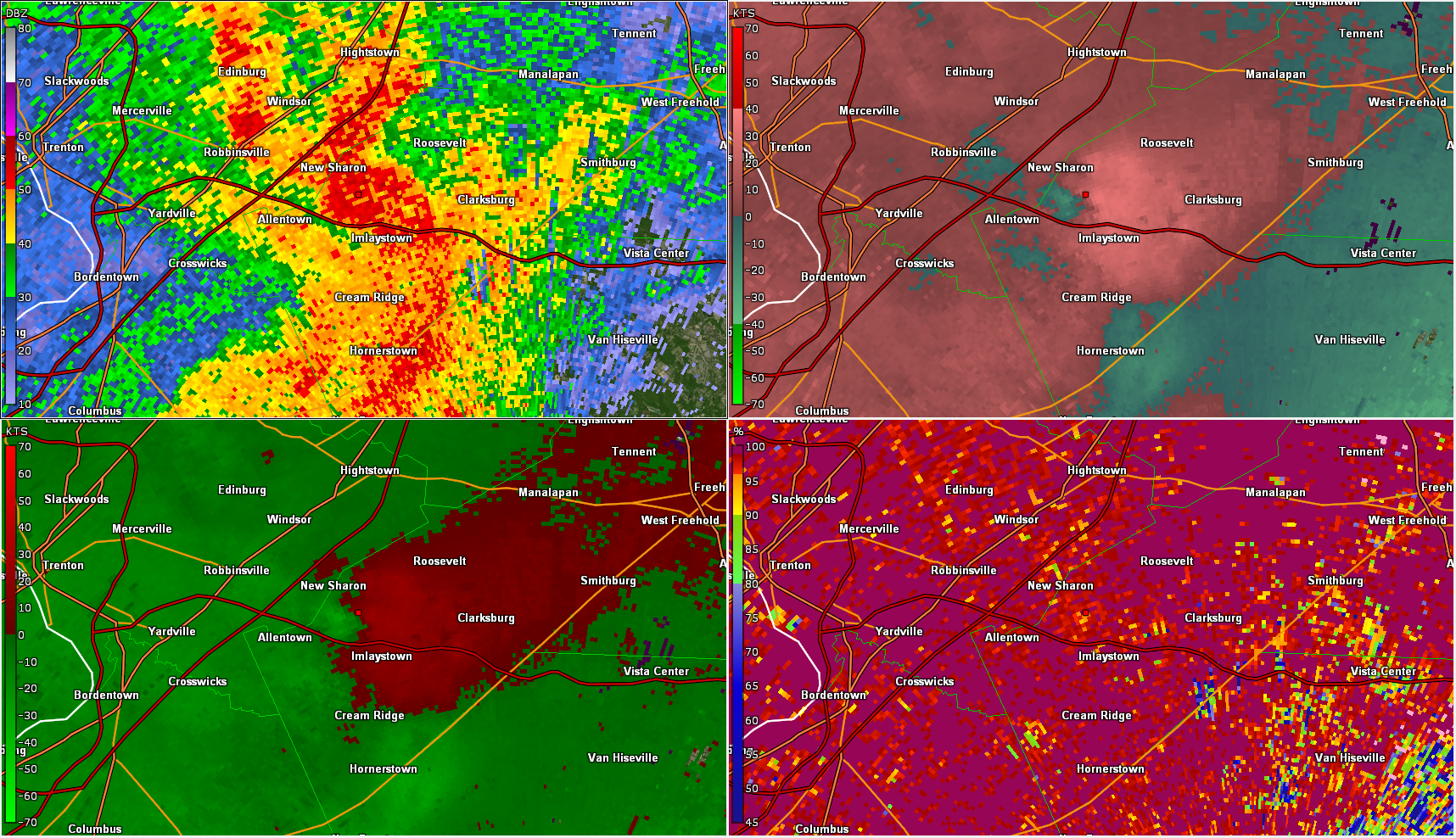
Notable Radar Imagery (GR2Analyst)
 |
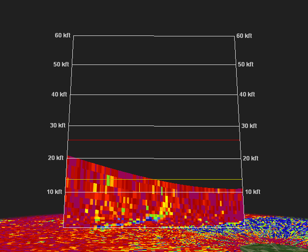 |
| Figure 1: KDOX radar reflectivity factor (z; top left), storm relative velocity (SRM; top right), differential reflectivity (ZDR, bottom left) and correlation coefficient (CC; bottom right),) for the 0.5 degree elevation angle valid at 2054 UTC 1 July 2021. This was shortly after the touchdown of the Harrington, DE tornado. A classic QLCS tornado is evident, with the close proximity to the KDOX radar fortuitous in providing a detailed look at the storm. A debris ball/tornado debris signature is clearly evident in the enhanced reflectivity values, reduced ZDR values, and particularly the very low CC values. A tight velocity couplet is seen in the SRM data. | Figure 2: A vertical cross section of CC data for the KDOX radar during the same volume scan as in Figure 1. This methodology can be used to determine the approximate height to which tornadic debris is being lofted. A tilted vertical trail of reduced CC values is seen extending from the surface, representing lofted debris. In this case, the TDS is quite shallow, less than 5,000 feet, a value typical of relatively weak (EF0 or EF1) tornadoes. The relatively low maximum height of the data (<20,000 ft) and its sloped appearance is a side effect of close proximity to the KDOX radar. |
 |
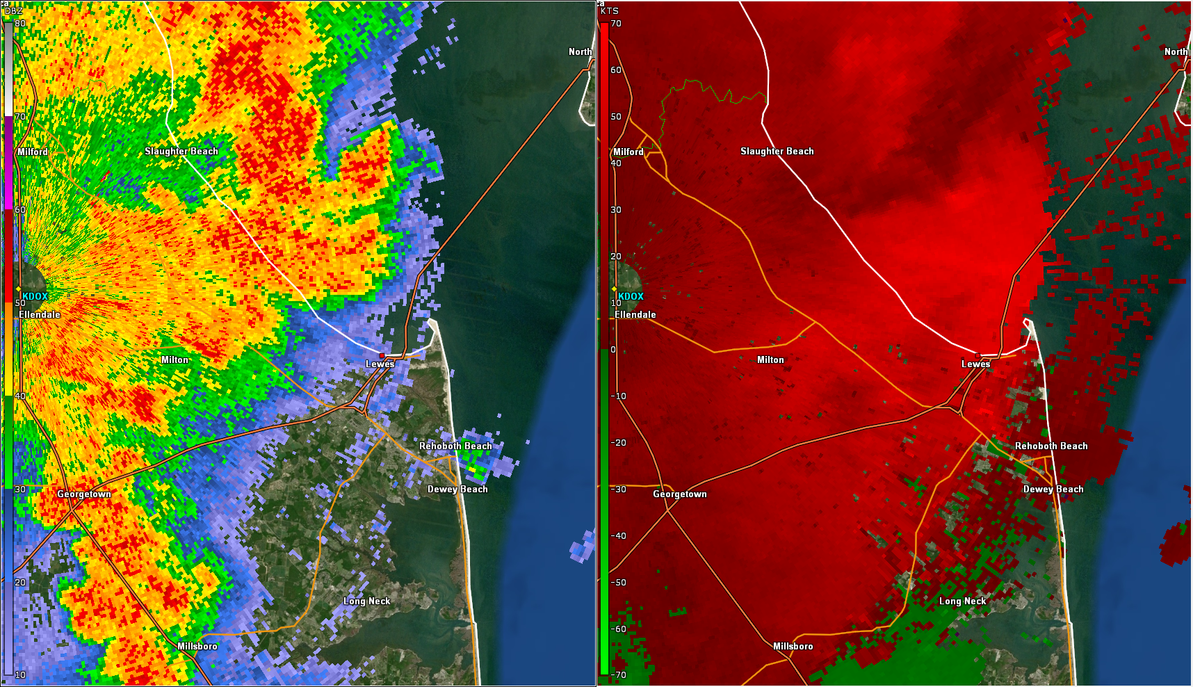 |
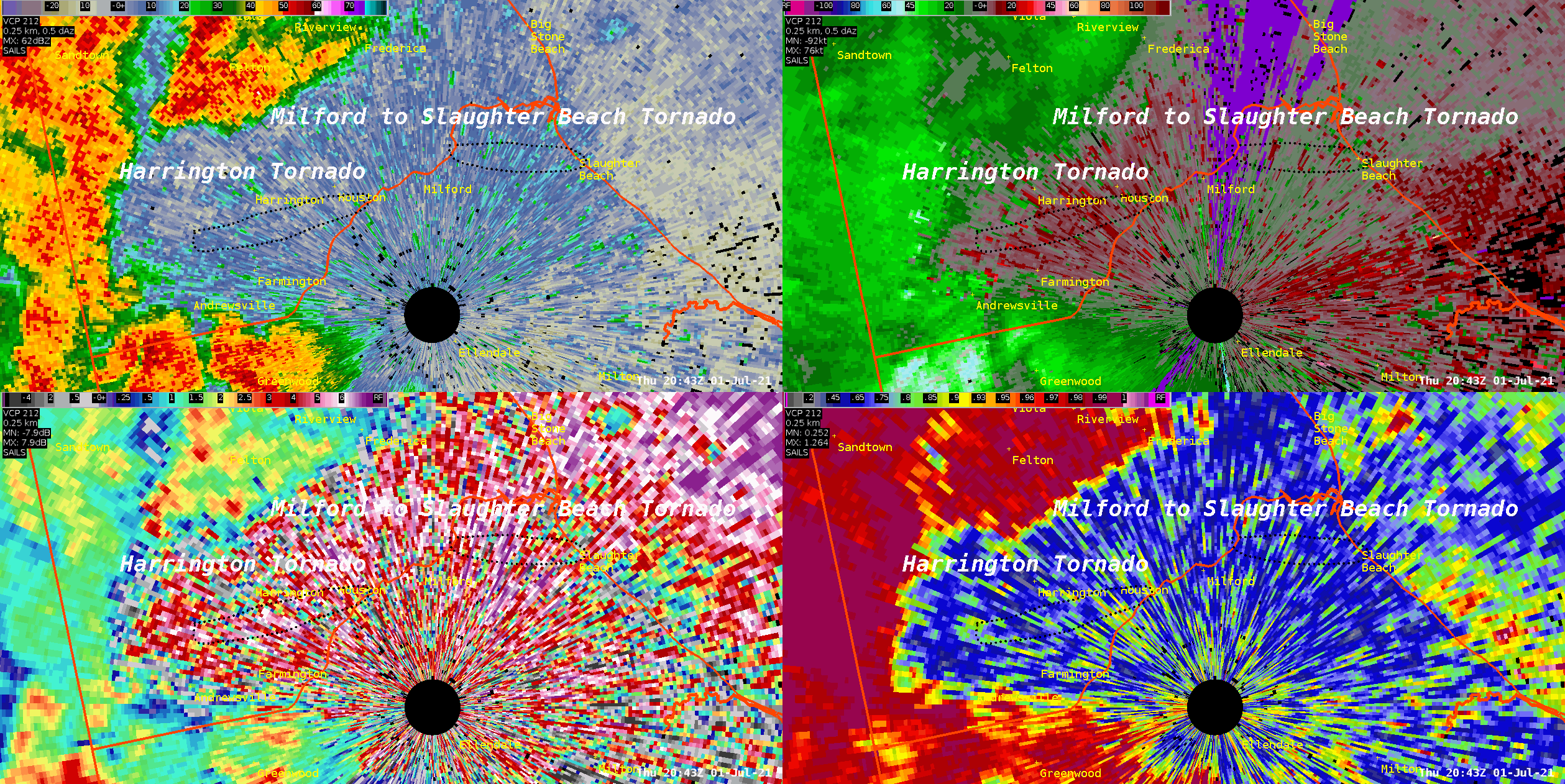
| Figure 3: Same as Figure 1 valid at 2104 UTC 1 July 2021, about 10 minutes after the Harrington tornado. This time, the Milford to Slaughter Beach tornado is seen. The radar signature is in many ways similar to the first tornado. A tight velocity couplet is seen in the SRM, with a pronounced hook echo in the reflectivity. There is considerably more noise in the ZDR and CC data, but a tornado debris signature can still be seen where the dot has been placed. The vertical structure of the TDS (as in Figure 2, not shown) was very similar to the Harrington tornado, not surprising given the near equal intensities of the tornadoes. | Figure 4: KDOX radar reflectivity factor (left), and base velocity (V; right), for the 0.5 degree elevation angle valid at 2115 UTC 1 July 2021. The line of storms became outflow dominant as it approached the coast, bringing an end to the tornadic threat. However, as the outflow surged ahead, strong straight line winds continued. A 64 mph wind gust was measured near Lewes several minutes before rain arrived. The velocity data shows widespread 50 to 60 kt (about 60 to 70 mph) winds at 1000 ft or less above ground level. |
 |
 |
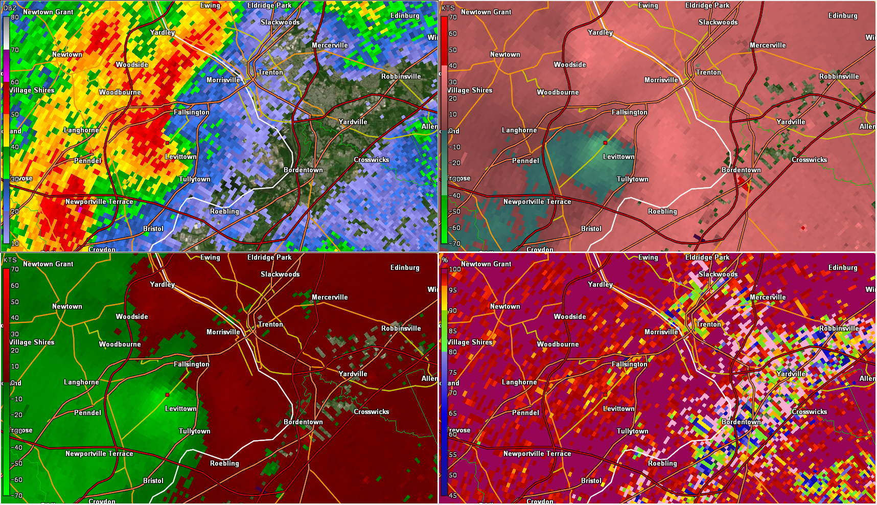
| Figure 5: KDIX radar reflectivity factor (z; top left), storm relative velocity (SRM; top right), base velocity(V, bottom left) and correlation coefficient (CC; bottom right) for the 0.5 degree elevation angle valid at 2100 UTC 1 July 2021. In addition to the tornadoes in Delaware, an area of rotation over lower Bucks County, embdedded within a broader line of thunderstorms, prompted a Tornado Warning at nearly the same time. Rotation is clearly seen near Levittown, PA in the SRM data, and impressively high velocities in excess of 50 kt are seen in the V data. Tree and power line damage was reported in the area, but there did not appear to be evidence of a tornado touchdown. Rather, it is more likely a rear flank downdraft surge around the circulation, associated with the high base velocity values, caused the wind damage. There is a bit of noise in the CC data, but the mostly uniform high values offer no evidence of a TDS like those seen with the Delaware tornadoes. The broader thunderstorm line as a whole also produced a number of instances of wind damage over eastern PA. | Figure 6: Same as Figure 5 valid at 2135 UTC 1 July 2021. After weakening for a time, rotation redeveloped with the line segment from Figure 5. This time, the segment had reorganized to display some characteristics of a "bookend vortex". The increase in rotation prompted the issuance of an additional Tornado Warning. However, there was little in the way of damage reported with this feature, and no evidence that a tornado occurred. The rotation soon weakened, but this line did produce a couple of sporadic wind damage reports all the way to the coast. |


 Coastal Flood
 Marine Forecasts
 Text Products
 Climate Information
 Skywarn
 Submit Storm Report
 Weather Event Archives
 Forecast Discussion
 Emergency Managers
 Briefing Page