
A heat wave over the Southwest will intensify this week, peaking and expanding into the Intermountain West and northern High Plains this weekend. Critical to extremely critical fire weather conditions are forecast from the Northwest and the northern Great Basin this weekend. Particularly Dangerous Situation Red Flag Warnings have been issued. Read More >
Overview
|
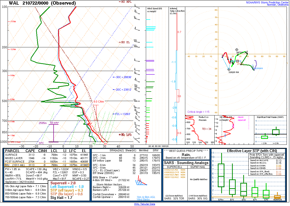
A cold front approached the mid-Atlantic from the north-northwest on July 21. The front was also associated with an unseasonably potent mid-level trough, which helped increase shear and lift over the region. With a seasonably warm air mass in place ahead of the front, widespread thunderstorms developed during the afternoon. An initial cluster of thunderstorms developed as early as late morning along the sea breeze in eastern New Jersey. These storms quickly became severe, producing both damaging winds and hail as well as locally heavy rainfall. As the front itself approached, additional storms developed, taking the form of mainly linear and multi-cellular clusters. Several of these storms also became severe. The most noteworthy event of the day was a very strong straight line wind event over Montgomery County, PA. Numerous trees and utilities were downed in that area by winds that likely reached 80 mph. Another damaging wind event occurred in Queen Anne’s County, MD. That event prompted some speculation of a tornado touchdown, but radar data and the nature of the damage suggested straight line winds were responsible there as well. As the cold front moved through, drier air moved into the region, and convection had largely dissipated or moved offshore by mid-evening. |
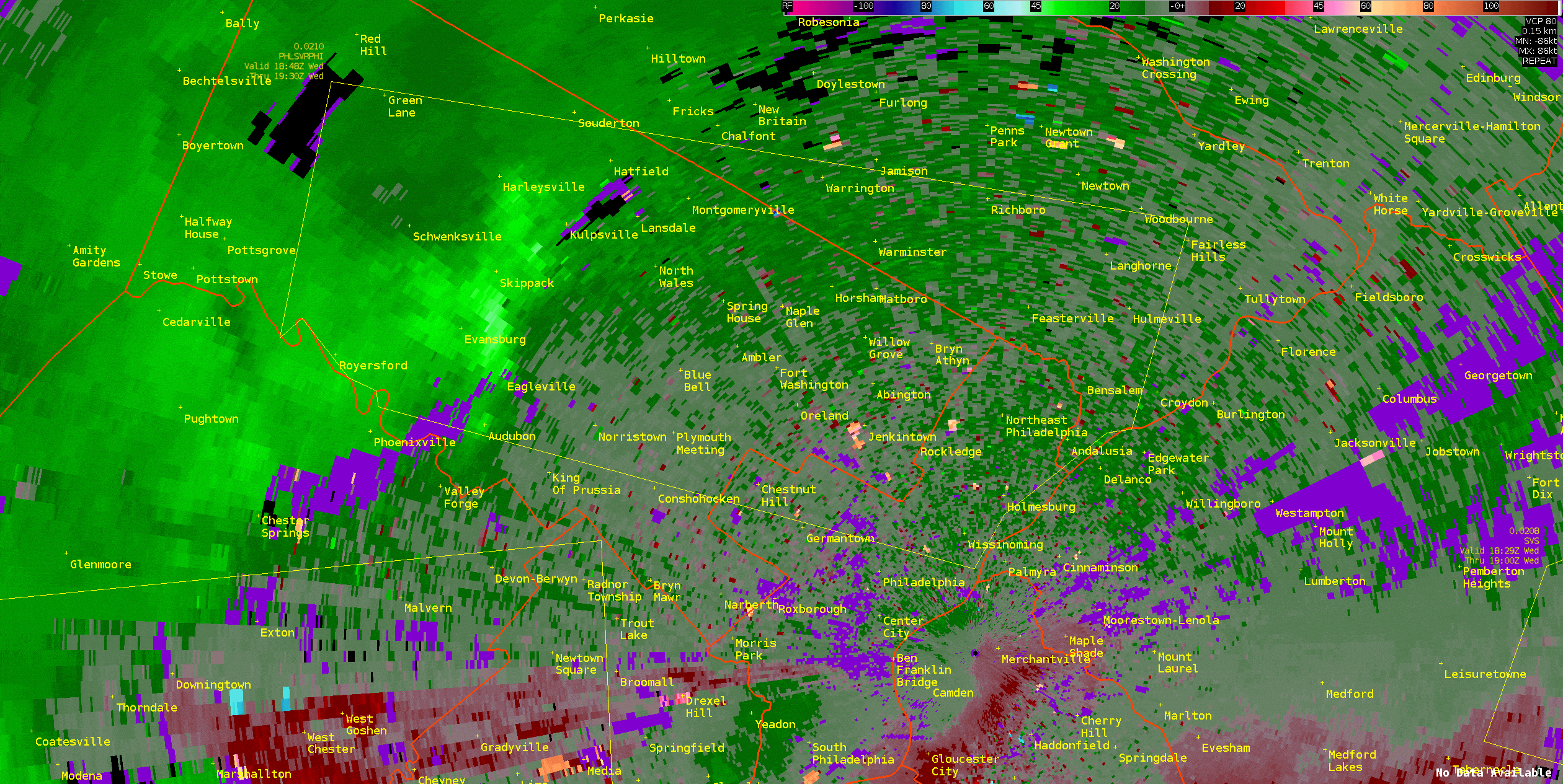 TPHL base velocity loop from about 2:50PM to 3:30PM on July 21, 2021. Intense winds, radar estimates at times to 80 mph, are seen over Montgomery County, which caused extensive damage. |
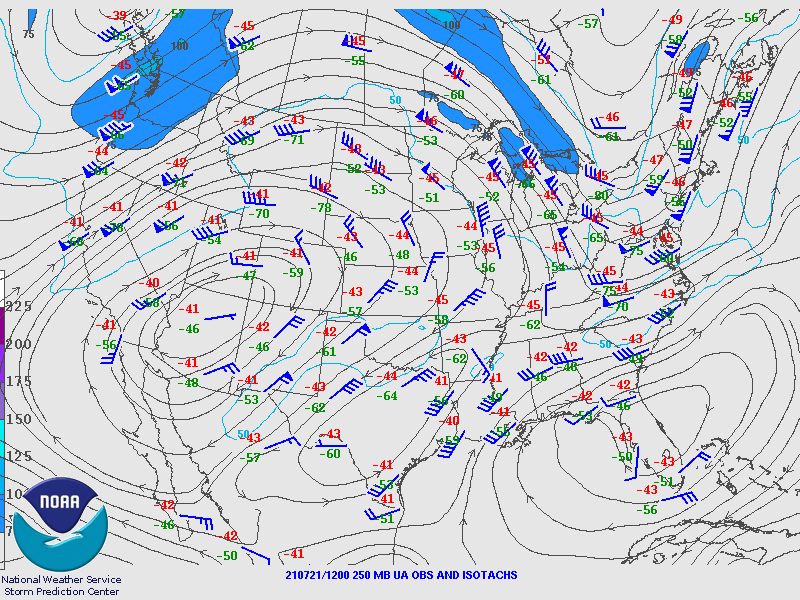
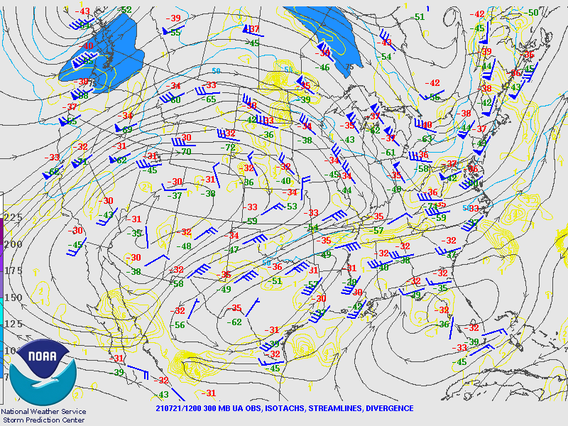
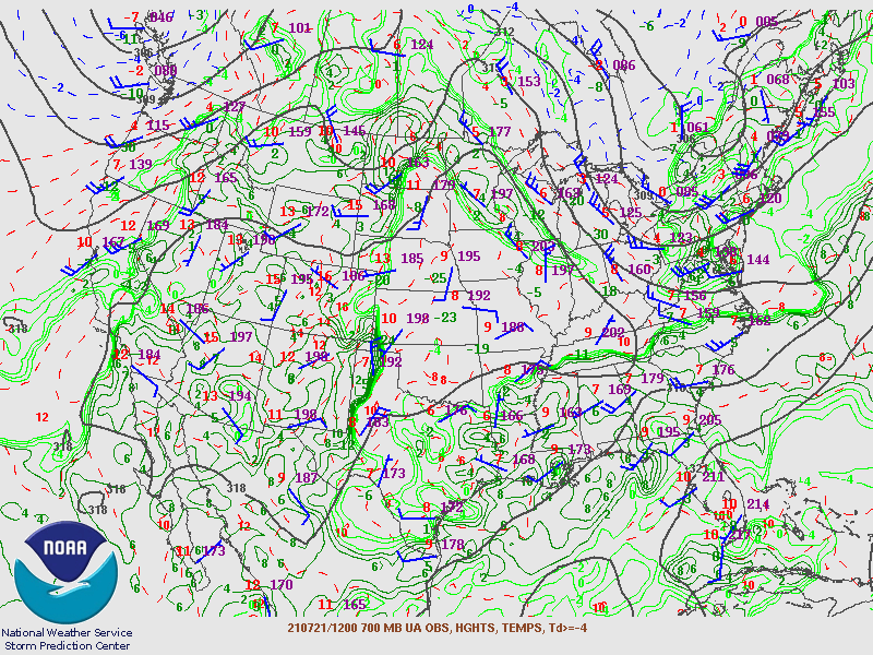
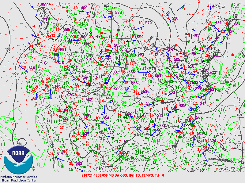
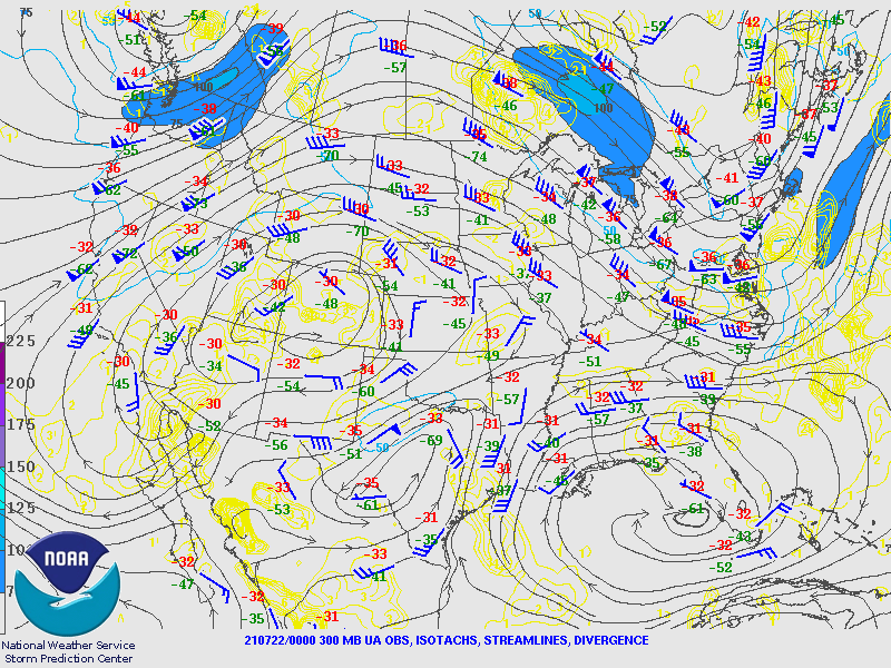
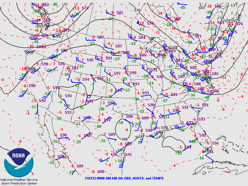
Synoptic Overview at 12z 21 Jul 2021 (courtesy of SPC)
 |
 |
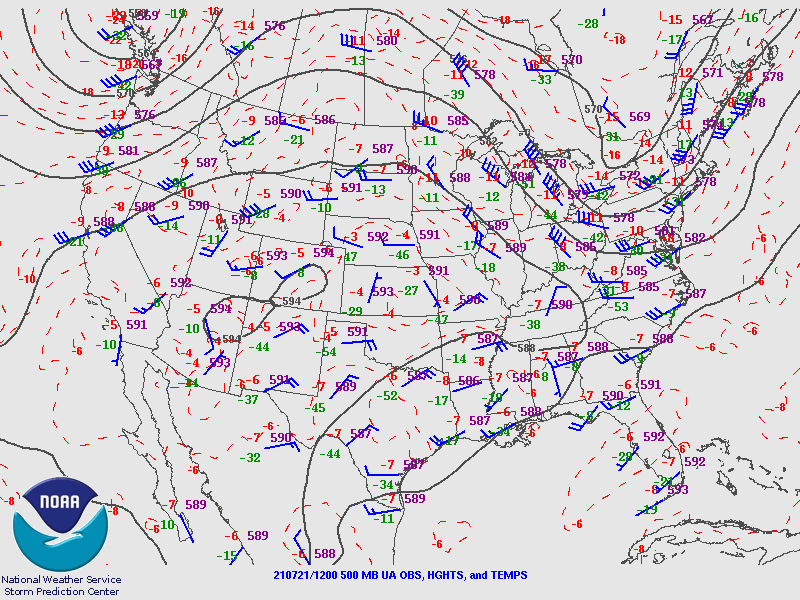 |
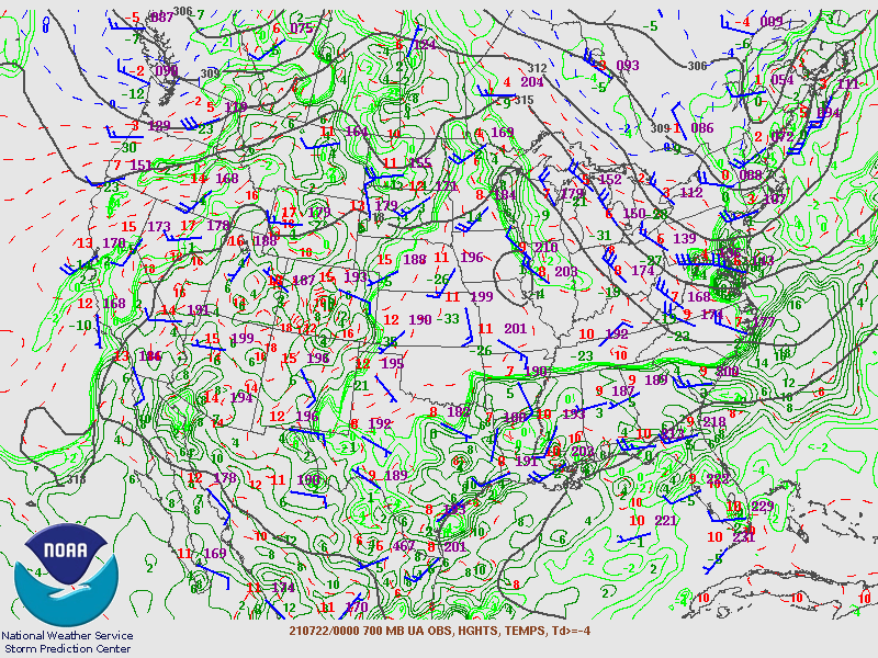
| Figure 1: 250-mb analysis | Figure 2: 300-mb analysis | Figure 3: 500-mb analysis |
 |
 |
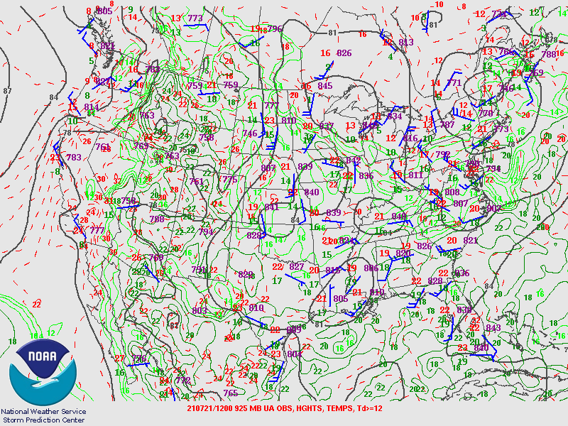 |
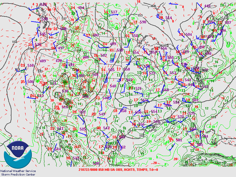
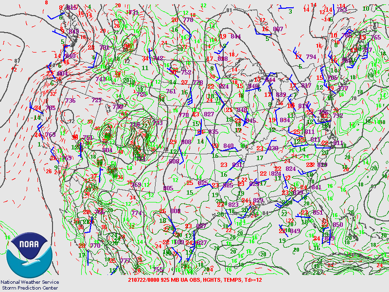
| Figure 4: 700-mb analysis | Figure 5: 850-mb analysis | Figure 6: 925-mb analysis |
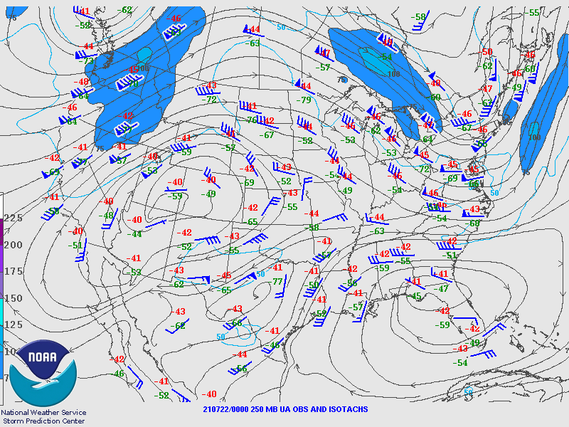
Synoptic Overview at 00z 22 Jul 2021 (courtesy of SPC)
 |
 |
 |
| Figure 7: 250-mb analysis | Figure 8: 300-mb analysis | Figure 9: 500-mb analysis |
 |
 |
 |
| Figure 10: 700-mb analysis | Figure 11: 850-mb analysis | Figure 12: 925-mb analysis |
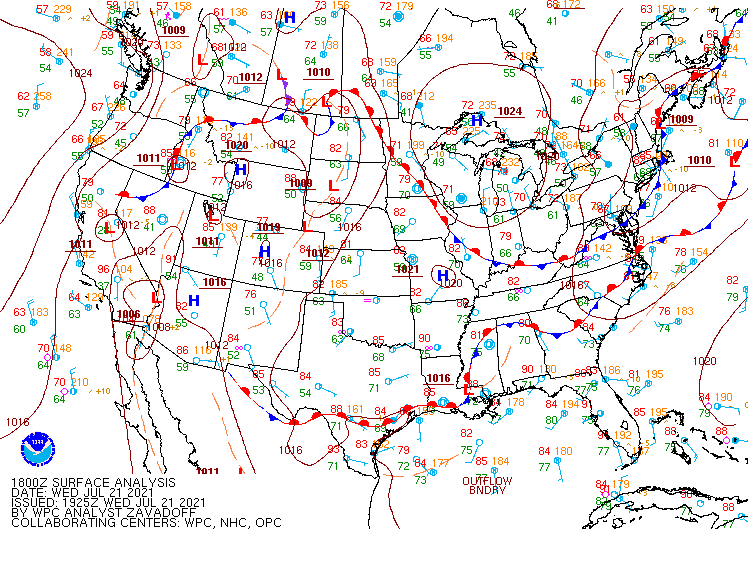
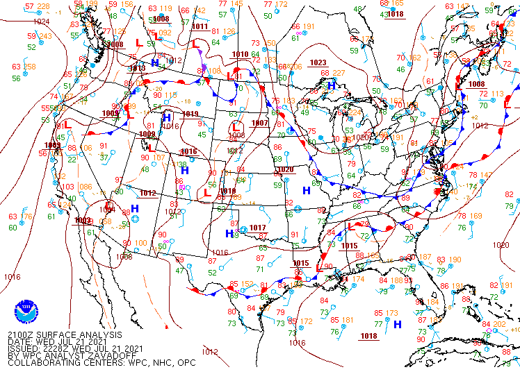
Surface Maps (courtesy of WPC)
 |
 |
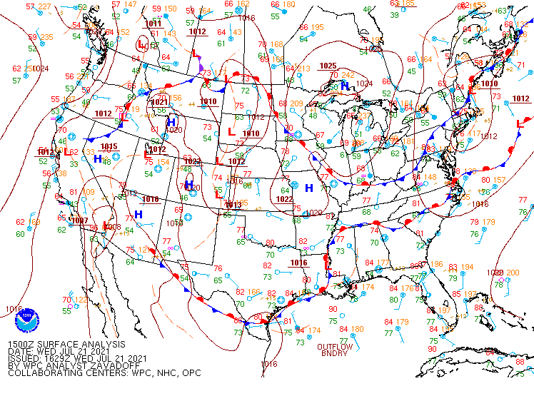 |
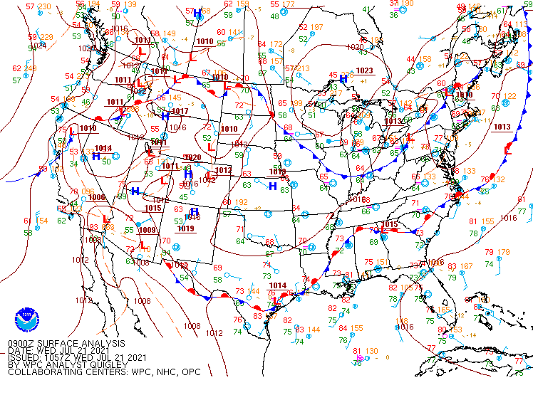
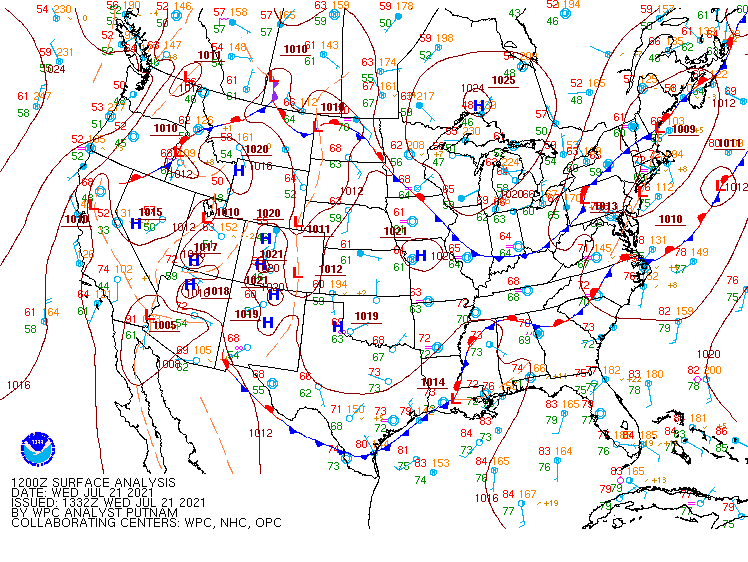
| Figure 13: 09z surface map | Figure 14: 12z surface map | Figure 15: 15z surface map |
 |
 |
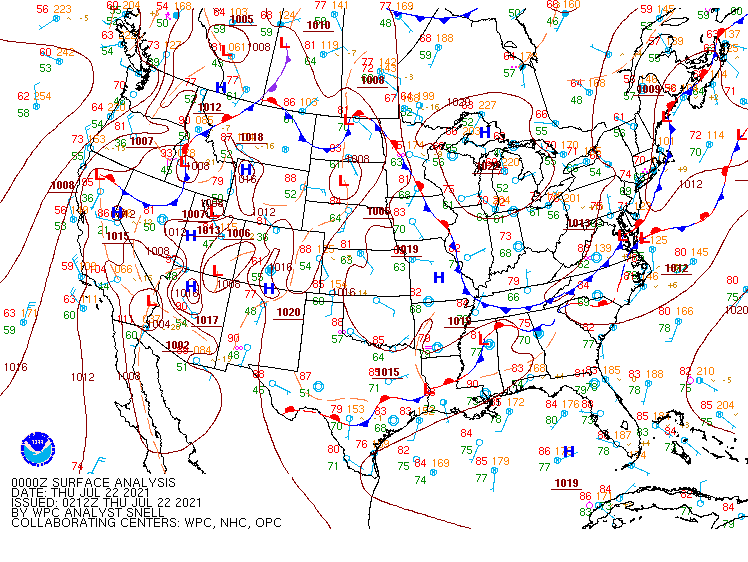 |
| Figure 16: 18z surface map | Figure 17: 21z surface map | Figure 18: 00z surface map |
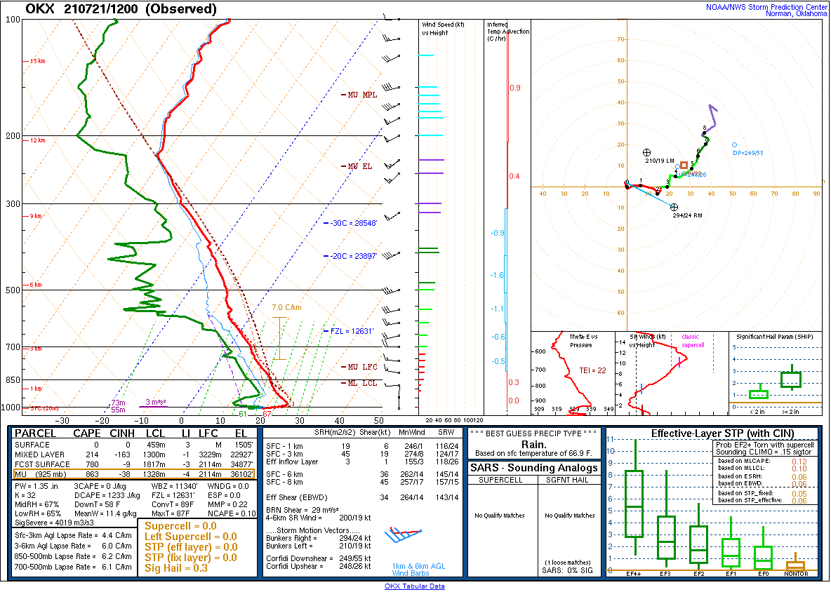 |
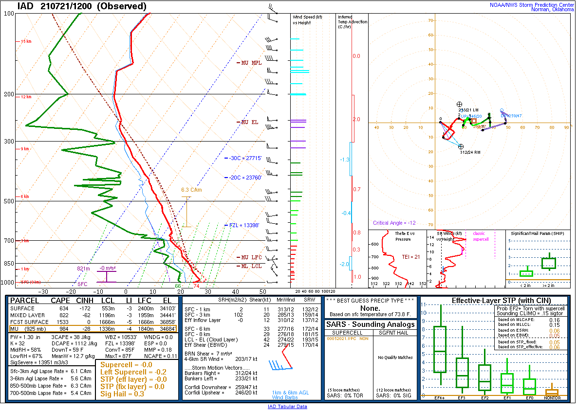 |
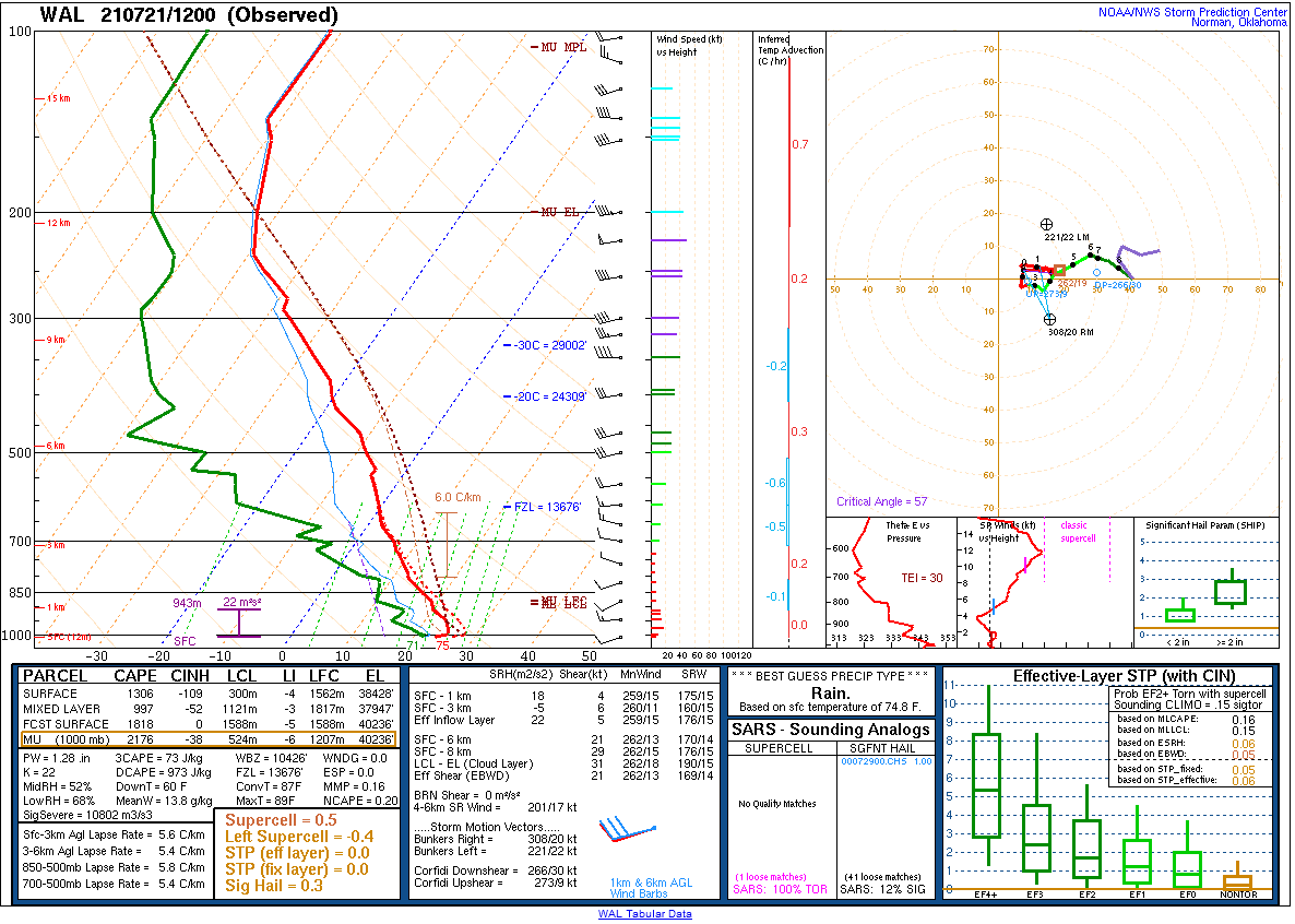 |
| Figure 19: 12z Long Island, NY sounding | Figure 20: 12z Sterling, VA sounding | Figure 21: 12z Wallops Island, VA sounding |
 |
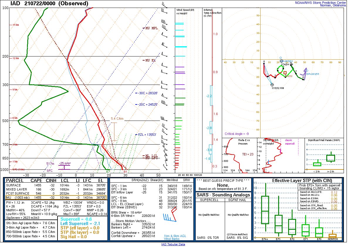 |
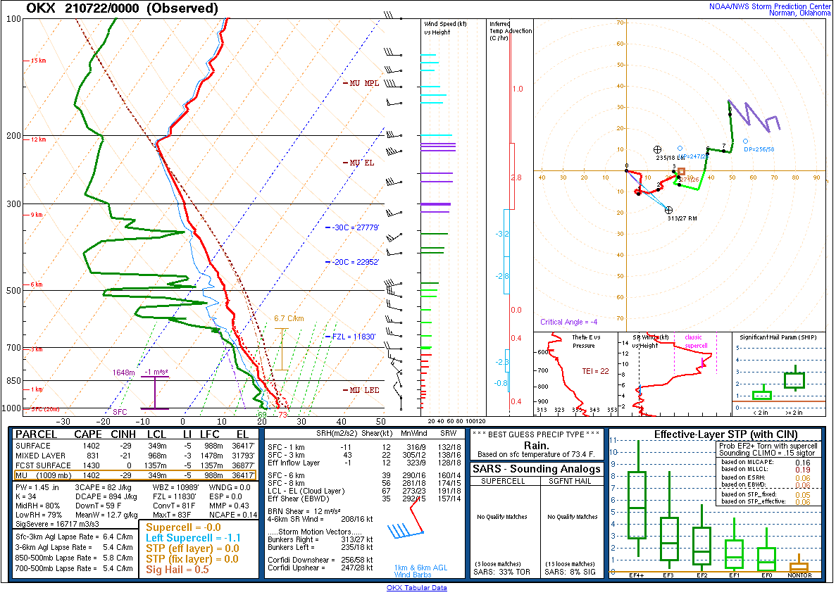
 |
| Figure 22: 00z Long Island, NY sounding | Figure 23: 00z Sterling, VA sounding | Figure 24: 00z Wallops Island, VA sounding |
 |
 |
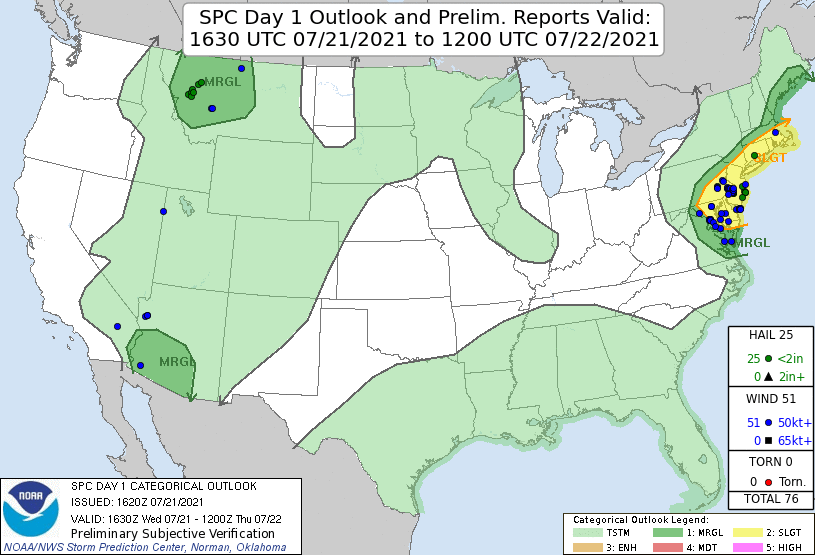 |
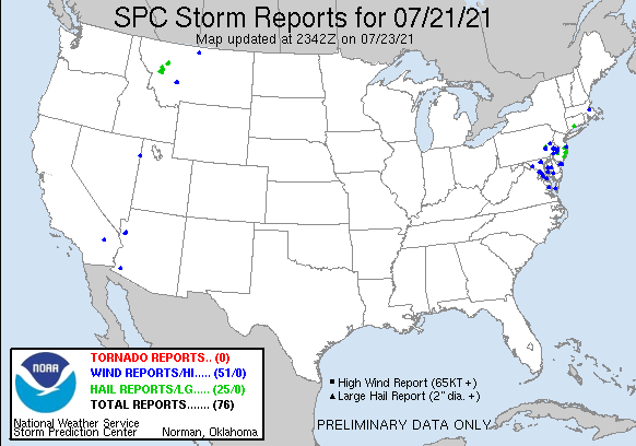
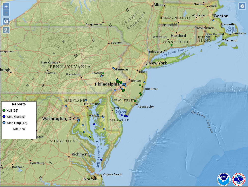
| Figure 1: National Preliminary Reports 12z 21 Jul 2021 to 12z 22 Jul 2021 | Figure 2: Zoomed Preliminary Reports for the same period. | Figure 3: Prelim Reports vs. 1630z SPC Convective Outlook |
Click here for a county warning area based plot of local storm reports and warnings/advisories issued for the 21 Jul 2021 event.
NWUS51 KPHI 220047
LSRPHI

PRELIMINARY LOCAL STORM REPORT...SUMMARY
NATIONAL WEATHER SERVICE MOUNT HOLLY NJ
847 PM EDT WED JUL 21 2021

..TIME...   ...EVENT...      ...CITY LOCATION...     ...LAT.LON...
..DATE...   ....MAG....      ..COUNTY LOCATION..ST.. ...SOURCE....
            ..REMARKS..

0105 PM     HAIL             BARNEGAT                39.75N 74.22W
07/21/2021  E0.25 INCH       OCEAN              NJ   PUBLIC


0220 PM     HAIL             DEPTFORD TWP            39.84N 75.12W
07/21/2021  E0.25 INCH       GLOUCESTER         NJ   TRAINED SPOTTER


0350 PM     HAIL             DELANCO                 40.05N 74.96W
07/21/2021  E0.70 INCH       BURLINGTON         NJ   TRAINED SPOTTER


0405 PM     HAIL             DEPTFORD TWP            39.83N 75.12W
07/21/2021  E0.70 INCH       GLOUCESTER         NJ   PUBLIC


0150 PM     HAIL             MANAHAWKIN              39.70N 74.26W
07/21/2021  E0.75 INCH       OCEAN              NJ   TRAINED SPOTTER


0205 PM     HAIL             2 WNW ALLENTOWN         40.62N 75.51W
07/21/2021  E0.75 INCH       LEHIGH             PA   TRAINED SPOTTER

            SOUTH WHITEHALL TOWNSHIP.

0345 PM     HAIL             LAKEWOOD                40.08N 74.17W
07/21/2021  E0.75 INCH       OCEAN              NJ   TRAINED SPOTTER


0400 PM     HAIL             RAMTOWN                 40.12N 74.14W
07/21/2021  E0.75 INCH       MONMOUTH           NJ   PUBLIC


0250 PM     HAIL             SCHWENKSVILLE           40.25N 75.46W
07/21/2021  E0.88 INCH       MONTGOMERY         PA   TRAINED SPOTTER


0400 PM     HAIL             WEST DEPTFORD TWP       39.84N 75.20W
07/21/2021  E0.88 INCH       GLOUCESTER         NJ   PUBLIC


0105 PM     HAIL             OCEAN ACRES             39.74N 74.28W
07/21/2021  M1.00 INCH       OCEAN              NJ   COCORAHS


0115 PM     HAIL             MANAHAWKIN              39.70N 74.26W
07/21/2021  E1.00 INCH       OCEAN              NJ   PUBLIC


0200 PM     HAIL             TEMPLE                  40.41N 75.93W
07/21/2021  E1.00 INCH       BERKS              PA   TRAINED SPOTTER


0305 PM     HAIL             EAST NORRITON           40.15N 75.33W
07/21/2021  E1.00 INCH       MONTGOMERY         PA   PUBLIC


0310 PM     HAIL             PLYMOUTH MEETING        40.11N 75.28W
07/21/2021  E1.00 INCH       MONTGOMERY         PA   TRAINED SPOTTER


0311 PM     HAIL             PLYMOUTH TWP            40.13N 75.30W
07/21/2021  M1.00 INCH       MONTGOMERY         PA   PUBLIC

            HAIL, TO THE SIZE OF QUARTERS (FROM MPING).

0320 PM     HAIL             LAKEHURST               40.01N 74.30W
07/21/2021  E1.00 INCH       OCEAN              NJ   PUBLIC


0320 PM     HAIL             GLOUCESTER TWP          39.82N 75.04W
07/21/2021  E1.00 INCH       CAMDEN             NJ   PUBLIC


0325 PM     HAIL             FLOURTOWN               40.11N 75.21W
07/21/2021  E1.00 INCH       MONTGOMERY         PA   PUBLIC

            PHOTO FROM SOCIAL MEDIA, HAIL ESTIMATED AT
            QUARTER SIZE IN FLOURTOWN. TIME ESTIMATED
            FROM RADAR.

0330 PM     HAIL             ABINGTON                40.12N 75.12W
07/21/2021  E1.00 INCH       MONTGOMERY         PA   TRAINED SPOTTER


0330 PM     HAIL             GLENSIDE                40.10N 75.15W
07/21/2021  E1.00 INCH       MONTGOMERY         PA   PUBLIC


0330 PM     HAIL             JENKINTOWN              40.09N 75.13W
07/21/2021  E1.00 INCH       MONTGOMERY         PA   PUBLIC


0420 PM     HAIL             GALLOWAY TWP            39.47N 74.51W
07/21/2021  E1.00 INCH       ATLANTIC           NJ   PUBLIC


0205 PM     HAIL             MANAHAWKIN              39.69N 74.26W
07/21/2021  E1.25 INCH       OCEAN              NJ   PUBLIC


0315 PM     HAIL             BLUE BELL               40.16N 75.26W
07/21/2021  E1.25 INCH       MONTGOMERY         PA   PUBLIC

            PHOTOS RELAYED ON SOCIAL MEDIA, OF HAIL
            SLIGHTLY LARGER THAN QUARTER SIZE. TIME
            ESTIMATED FROM RADAR.

0132 PM     MARINE TSTM WIND SEASIDE HEIGHTS         39.95N 74.07W
07/21/2021  M39 MPH          OCEAN              NJ   MESONET


0210 PM     MARINE TSTM WIND 2 WNW SHIP BOTTOM       39.66N 74.21W
07/21/2021  M39 MPH          ANZ451             NJ   MESONET

            MEASURED AT LBI ISLAND SURF (XLBI)
            WEATHERFLOW GAUGE.

0230 PM     MARINE TSTM WIND 1 NE MANASQUAN          40.13N 74.03W
07/21/2021  M40 MPH          MONMOUTH           NJ   MESONET

            SEA GIRT.

0535 PM     MARINE TSTM WIND CAPE MAY POINT          38.93N 74.96W
07/21/2021  M40 MPH          CAPE MAY           NJ   PUBLIC

            MEASURED AT CAPE MAY POINT CWOP GAUGE.

0245 PM     MARINE TSTM WIND 1 ESE MANASQUAN         40.12N 74.03W
07/21/2021  M41 MPH          MONMOUTH           NJ   MESONET

            MEASURED AT SEA GIRT NJ WXNET SITE.

0100 PM     TSTM WND GST     BEACH HAVEN             39.56N 74.24W
07/21/2021  M42 MPH          OCEAN              NJ   MESONET


0142 PM     MARINE TSTM WIND TUCKERTON               39.60N 74.34W
07/21/2021  M45 MPH          OCEAN              NJ   MESONET


0120 PM     TSTM WND GST     OCEAN ACRES             39.74N 74.28W
07/21/2021  M50 MPH          OCEAN              NJ   MESONET

            WXFLOW.

0120 PM     MARINE TSTM WIND SURF CITY               39.66N 74.17W
07/21/2021  M50 MPH          OCEAN              NJ   MESONET


0300 PM     TSTM WND GST     WEST GROVE              39.82N 75.82W
07/21/2021  M51 MPH          CHESTER            PA   MESONET


0310 PM     TSTM WND GST     PLYMOUTH MEETING        40.11N 75.28W
07/21/2021  M51 MPH          MONTGOMERY         PA   TRAINED SPOTTER


0320 PM     TSTM WND GST     FORT WASHINGTON         40.15N 75.21W
07/21/2021  M55 MPH          MONTGOMERY         PA   MESONET

            MESOWEST.

0533 PM     TSTM WND GST     1 SSW NORTH CAPE MAY    38.97N 74.96W
07/21/2021  M58 MPH          ANZ431             NJ   MESONET

            NOS SITE AT NORTH CAPE MAY MEASURES 58MPH
            GUST (TIME BETWEEN 5:30 AND 5:35 PM).

0518 PM     MARINE TSTM WIND 9 WNW CAPE MAY POINT    38.99N 75.11W
07/21/2021  M59 MPH          ANZ431             NJ   BUOY

            MEASURED AT BRANDYWINE SHOAL LIGHT (BRND1),
            WITH A PEAK GUST OF 80MPH AT 5:24PM.
            ANEMOMETER HEIGHT OF 23 METERS.

0539 PM     TSTM WND GST     CAPE MAY HARBOR         38.95N 74.89W
07/21/2021  M61 MPH          CAPE MAY           NJ   OTHER FEDERAL

            61 MPH GUST MEASURED AT CAPE MAY HARBOR
            OBSERVATION SITE (CAPN4).

0215 PM     TSTM WND DMG     1 WSW ALLENTOWN         40.60N 75.49W
07/21/2021                   LEHIGH             PA   911 CALL CENTER

            WIDESPREAD TREE DAMAGE IN WEST ALLENTOWN.

0220 PM     TSTM WND DMG     2 SSE ALLENTOWN         40.58N 75.46W
07/21/2021                   LEHIGH             PA   UTILITY COMPANY

            WIRES DOWN SOUTH OF ALLENTOWN. TIME
            ESTIMATED FROM RADAR.

0220 PM     TSTM WND DMG     1 NW WEST LAWN          40.33N 76.00W
07/21/2021                   BERKS              PA   TRAINED SPOTTER

            PHOTO OF LARGE TREE BRANCHES DOWN ON WIRES
            IN WEST LAWN PA. TIME ESTIMATED BY SPOTTER.

0224 PM     TSTM WND DMG     SPRING TWP              40.32N 76.01W
07/21/2021                   BERKS              PA   TRAINED SPOTTER

            LARGE BRANCH DOWN IN SPRING TOWNSHIP, TIME
            ESTIMATED FROM RADAR.

0305 PM     TSTM WND DMG     AUDUBON                 39.89N 75.09W
07/21/2021                   CAMDEN             NJ   PUBLIC

            LARGE BRANCH DOWN ON FENCE IN AUDUBON, PHOTO
            RELAYED VIA SOCIAL MEDIA. TIME ESTIMATED
            FROM RADAR.

0305 PM     TSTM WND DMG     EAST NORRITON           40.15N 75.33W
07/21/2021                   MONTGOMERY         PA   PUBLIC

            NUMEROUS TREES DOWN.

0307 PM     TSTM WND DMG     NORTH WALES             40.21N 75.29W
07/21/2021                   MONTGOMERY         PA   PUBLIC

            PHOTO OF LARGE TREE DOWN IN UPPER GWYNEDD
            TOWNSHIP. TIME ESTIMATED FROM RADAR.

0310 PM     TSTM WND DMG     1 WNW BLUE BELL         40.16N 75.28W
07/21/2021                   MONTGOMERY         PA   PUBLIC

            NUMEROUS TREES DOWN ON WIRES IN WHITPAIN
            TOWNSHIP. TIME ESTIMATED FROM RADAR.

0315 PM     TSTM WND DMG     2 WNW BLUE BELL         40.17N 75.29W
07/21/2021                   MONTGOMERY         PA   TRAINED SPOTTER

            NUMEROUS PHOTOS OF LARGE TREE LIMBS DOWN IN
            THE IN THE CENTER SQUARE AREA OF BLUE BELL.
            TIME ESTIMATED FROM RADAR.

0320 PM     TSTM WND DMG     1 S FORT WASHINGTON     40.13N 75.21W
07/21/2021                   MONTGOMERY         PA   PUBLIC

            TREES DOWN NEAR THE PENNSYLVANIA TURNPIKE.

0328 PM     TSTM WND DMG     ABINGTON                40.12N 75.12W
07/21/2021                   MONTGOMERY         PA   PUBLIC

            LARGE TREE SHEARED APART IN ABINGTON
            TOWNSHIP. PHOTO RELAYED ON SOCIAL MEDIA.
            TIME ESTIMATED FROM RADAR.

0340 PM     TSTM WND DMG     1 WNW CHESTER TWP       39.84N 75.40W
07/21/2021                   DELAWARE           PA   FIRE DEPT/RESCUE

            WIRES DOWN ON CARTER AVENUE IN CHESTER
            TOWNSHIP. TIME ESTIMATED FROM RADAR.

0340 PM     TSTM WND DMG     2 NW HOLMESBURG         40.06N 75.05W
07/21/2021                   PHILADELPHIA       PA   PUBLIC

            TREES ON WIRES ON STANWOOD ST IN RHAWNHURST.

0345 PM     TSTM WND DMG     TACONY                  40.03N 75.05W
07/21/2021                   PHILADELPHIA       PA   PUBLIC

            TREES DOWN NEAR VOGT RECREATION CENTER IN
            TACONY. TIME ESTIMATED FROM RADAR.

0350 PM     TSTM WND DMG     2 ESE NEW ALBANY        39.99N 74.94W
07/21/2021                   BURLINGTON         NJ   PUBLIC

            LARGE TREE LIMBS DOWN AND BLOCKING
            BRIDGEBORO ROAD NEAR THE WESTFIELD ROAD
            INTERSECTION IN MOORESTOWN. TIME ESTIMATED
            FROM RADAR.

0351 PM     TSTM WND DMG     DELANCO                 40.05N 74.96W
07/21/2021                   BURLINGTON         NJ   PUBLIC

            WIRES DOWN IN DELANCO NEAR BORDER WITH
            RIVERSIDE TOWNSHIP/RANCOCAS RIVER. TIME
            ESTIMATED FROM RADAR.

0355 PM     TSTM WND DMG     1 ESE QUEEN ANNE        38.92N 75.94W
07/21/2021                   CAROLINE           MD   PUBLIC

            TREE DOWN ACROSS ALTERNATE MARYLAND ROUTE
            404.

0400 PM     TSTM WND DMG     2 ESE RAMTOWN           40.11N 74.11W
07/21/2021                   OCEAN              NJ   PUBLIC

            WIRES DOWN ON ROAD IN HERBERTSVILLE, PHOTO
            RELAYED THROUGH SOCIAL MEDIA. TIME ESTIMATED
            FROM RADAR.

0405 PM     TSTM WND DMG     QUEENSTOWN              38.99N 76.15W
07/21/2021                   QUEEN ANNE'S       MD   EMERGENCY MNGR

            TREES DOWN ALONG US ROUTE 301 AT DEL RHODES
            AVENUE.

0532 PM     TSTM WND DMG     LOWER TOWNSHIP          38.98N 74.93W
07/21/2021                   CAPE MAY           NJ   TRAINED SPOTTER

            TREE DOWN IN CAPE ROAD ROAD IN LOWER
            TOWNSHIP. TIME ESTIMATED FROM RADAR.

0536 PM     TSTM WND DMG     1 SW WILDWOOD CREST     38.97N 74.85W
07/21/2021                   CAPE MAY           NJ   PUBLIC

            TELEPHONE POLE SNAPPED IN HALF ON W PRESTON
            AVE IN WILDWOOD CREST. PHOTO RELAYED ON
            SOCIAL MEDIA. TIME ESTIMATED FROM RADAR.

0536 PM     TSTM WND DMG     1 NNW CAPE MAY HARBOR   38.96N 74.89W
07/21/2021                   ANZ453             NJ   PUBLIC

            WIRES DOWN ON OCEAN DRIVE IN CAPE MAY. TIME
            ESTIMATED FROM RADAR.


&&

$$
NOUS41 KPHI 222144
PNSPHI
MDZ012-015-019-020-230300-

Public Information Statement
National Weather Service Mount Holly NJ
544 PM EDT Thu Jul 22 2021

...THUNDERSTORM WIND DAMAGE IN EASTERN MARYLAND NEAR QUEENSTOWN
ON JULY 21...

A strong downburst from a thunderstorm caused a swath of wind
damage in a small area to the east northeast of Queenstown,
Maryland around 4:05 PM on the afternoon of July 21, 2021.

The strong winds moved across a farm field on 4-H Park Road
before encountering a stand of trees along the southbound side of
US Route 301. Numerous trees were snapped with large limbs and
branches falling mainly to the east toward the highway. Much of
the damage occurred to soft-wood pines.

The effects continued on the other side of US Route 301 in the
Nottingham Lane neighborhood. Yard furniture and play equipment
was either tossed about or significantly damaged. Sections of
fencing were also broken. However, none of the houses in the
neighborhood appear to have been damaged.

There was no evidence of rotation on the radar at that time.
Based on the type and extent of the damage, the wind gusts are
estimated to have been around 55 to 65 MPH.

We extend our appreciation to the Queen Anne's County Office of
Emergency Management and to local residents for providing numerous
images of the damage.

$$

Iovino
Notable Radar Imagery (GR2Analyst and AWIPS)
 |
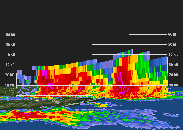 |
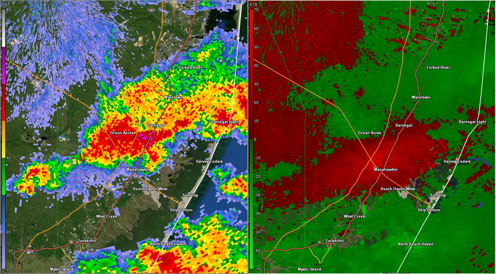
| Figure 1: KDIX radar reflectivity factor (left) and base velocity (right) for the 0.5 degree elevation angle valid at 1655 UTC 21 July 2021. Storms developed in the early afternoon along the sea breeze in coastal New Jersey. This image shows a good example of a downburst. Green indicates wind moving towards the radar (to the north in this case) while reds indicate wind moving away from the radar. Given the radar-indicated strength of the outbound (red) velocities, winds to near severe strength were likely occurring near Manahawkin. | Figure 2: KDIX vertical cross-section of reflectivity for the 1650 UTC volume scan, taken across the cluster of storms in Figure 1 (from west of Ocean Acres to east of Barnegat Light). In addition to strong winds, these storms became noteworthy hail producers. The approaching trough helped to steepen lapse rates and bring colder air in aloft, which is favorable for hail formation. The presence of 60 dbz (denoted by pink colors) at heights above 20,000 feet was a strong indicator that severe hail was likely with these storms. Hail of quarter to half dollar size was reported in the areas of Manahawkin to Ocean Acres. |
 |
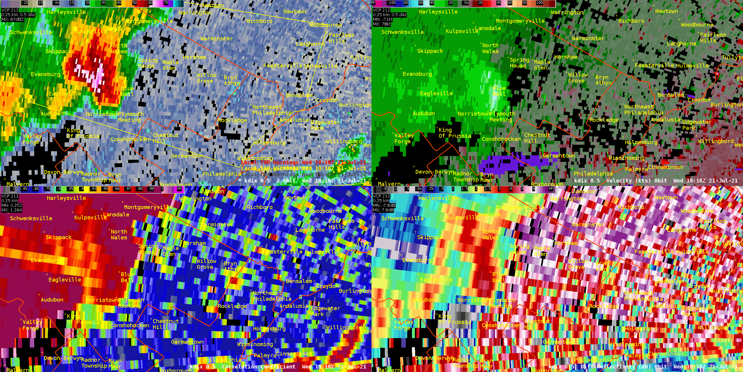 |
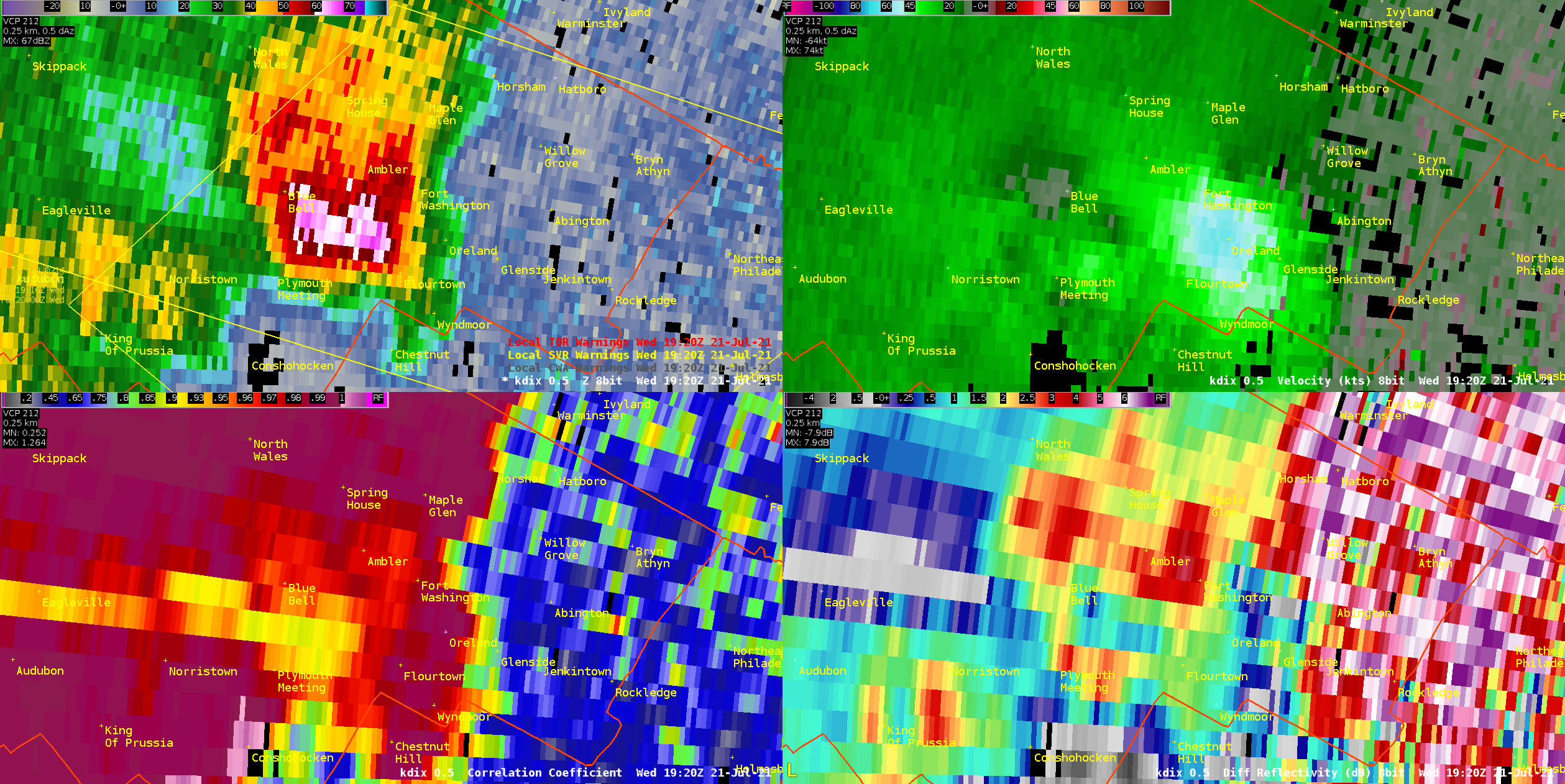
| Figure 3: KDIX radar reflectivity factor (top left), base velocity (v, top right), correlation coefficient (CC, bottom right) and differential reflectivity (ZDR, bottom right) valid at 1920 UTC 21 July 2021. This provides another look at the Montgomery County wind event. Radar estimated velocities of around 70 mph are present. The closer TPHL radar (in the Overview section) showed even higher winds. In addition, the reduced values of CC and ZDR near Blue Bell, coupled with the high reflectivity, are indicators of hail. This storm did indeed produce hail to half dollar size in addition to destructive winds, a rare combination for our region. | Figure 4: Same as Figure 3, but looped over a period from about 1910 to 1930 UTC. The lengthy path of both high winds and severe hail is evident. Tens of thousands of customers lost power with dozens if not hundreds of trees snapped or uprooted. The nature of the event likely qualifies it as a macroburst, a large and long lasting downburst. Winds gradually began to abate as the cell moved into Philadelphia County, though some residual wind damage was observed there as well. |
 |
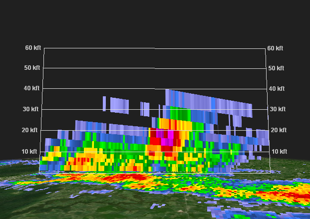 |
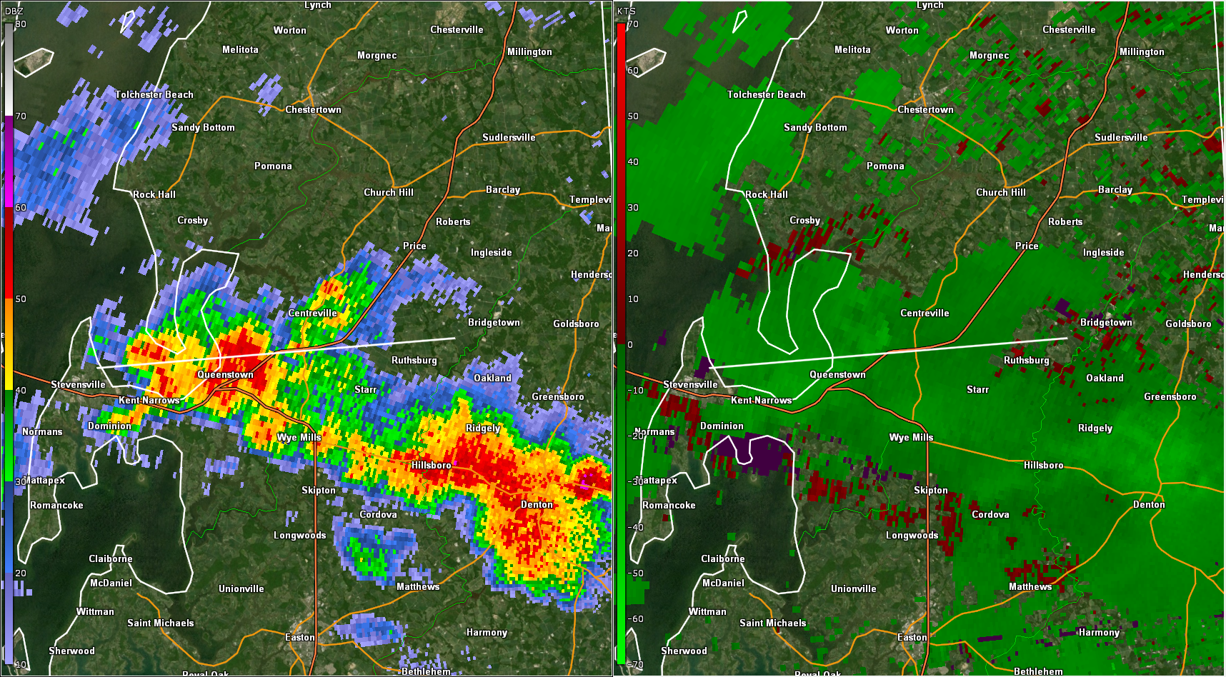
| Figure 5: KDOX radar reflectivity factor (left) and base velocity (right) for the 0.5 degree elevation angle valid at 2006 UTC 21 July 2021. Around this time, a number of wind damage reports were received east-northeast of Queenstown. The storms appear fairly run of the mill in the reflectivity imagery, and the base velocity data is also unimpressive. However, dozens of trees (mostly softwood pine) were snapped or lost large limbs, and residential yard furniture was tossed about, prompting some speculation that a tornado occurred. The white line denotes the line along which the cross-section in Figure 6 was taken. | Figure 6: KDOX vertical cross-section of reflectivity for the 2006 UTC volume scan, taken along the line shown in Figure 5. While the data in Figure 5 were unimpressive, this image may hold the key to the Queen Anne’s wind event. An elevated core of 60+ dbz echoes is seen near 20,000 ft. The rapid collapse of this core likely generated a downburst of winds around 60 mph which caused the area of localized damage. Because of its distance and angle from the radar, it is unlikely KDOX would have detected such a downburst. |


 Coastal Flood
 Marine Forecasts
 Text Products
 Climate Information
 Skywarn
 Submit Storm Report
 Weather Event Archives
 Forecast Discussion
 Emergency Managers
 Briefing Page