
A heat wave over the Southwest will intensify this week, peaking and expanding into the Intermountain West and northern High Plains this weekend. Critical to extremely critical fire weather conditions are forecast from the Northwest and the northern Great Basin this weekend. Particularly Dangerous Situation Red Flag Warnings have been issued. Read More >
Overview
|
A slow-moving, anomalously deep upper level trough moved from the Missouri Valley towards the Tennessee Valley and Southeast US over the course of October 27 – October 29, 2021. Meanwhile, strong high pressure was present over northern New England and much of southeast Canada. As the trough slowly moved eastward, favorable jet dynamics and increasing baroclinic forcing allowed secondary low pressure began to develop close to the southern mid-Atlantic coastline on October 29. This coastal low would go on to affect the region for much of October 29 and 30 before slowly moving northward into New England. This system brought several impacts to the local area, but chief among them was tidal flooding. The storm’s slow movement caused a long duration period of onshore flow to occur, driving water towards the coast and into local bays and tidal rivers, with the persistence of the flow preventing water from draining back out to sea. Many local tidal gauges exceeded flood stage as a result, including some instances of moderate to major flooding on the Chesapeake Bay, Delaware Bay, and tidal Delaware River. As the storm made its closest approach, winds increased in strength over the area. The low pressure center was not particularly strong, with a central pressure of only around 995 to 1000 mb. However, it was large in size, and the presence of the strong high to the north created a tight pressure gradient. Onshore (easterly) winds became gusty as a result. Strong winds were mainly a concern only near the coast and over the waters, but in those areas, some gusts of near to above 60 mph were measured. A period of rainfall, which was locally heavy, also affected much of the region, but freshwater hydrologic impacts were very limited as rainfall amounts were insufficient to cause more than nuisance flooding. This page summarizes the storm’s effects on the area, particularly the significant and rather unusual tidal flooding event which occurred during its passage. |
 WPC Surface Analysis maps from 00z 29 Oct 2021 through 00z 31 Oct 2021, showing the evolution of the coastal storm which affected the area. Click to enlarge. |
Synoptic Overview at 00z 29 Oct 2021 (courtesy of SPC)
 |
 |
 |
| Figure 1: 250-mb analysis | Figure 2: 300-mb analysis | Figure 3: 500-mb analysis |
 |
 |
 |
| Figure 4: 700-mb analysis | Figure 5: 850-mb analysis | Figure 6: 925-mb analysis |
Synoptic Overview at 12z 29 Oct 2021 (courtesy of SPC)
 |
 |
 |
| Figure 7: 250-mb analysis | Figure 8: 300-mb analysis | Figure 9: 500-mb analysis |
 |
 |
 |
| Figure 10: 700-mb analysis | Figure 11: 850-mb analysis | Figure 12: 925-mb analysis |
Synoptic Overview at 00z 30 Oct 2021 (courtesy of SPC)
 |
 |
 |
| Figure 13: 250-mb analysis | Figure 14: 300-mb analysis | Figure 15: 500-mb analysis |
 |
 |
 |
| Figure 16: 700-mb analysis | Figure 17: 850-mb analysis | Figure 18: 925-mb analysis |
Synoptic Overview at 12z 30 Oct 2021 (courtesy of SPC)
 |
 |
 |
| Figure 19: 250-mb analysis | Figure 20: 300-mb analysis | Figure 21: 500-mb analysis |
 |
 |
 |
| Figure 22: 700-mb analysis | Figure 23: 850-mb analysis | Figure 24: 925-mb analysis |
NWUS51 KPHI 300822
LSRPHI

PRELIMINARY LOCAL STORM REPORT...SUMMARY
NATIONAL WEATHER SERVICE MOUNT HOLLY NJ
422 AM EDT SAT OCT 30 2021

..TIME...   ...EVENT...      ...CITY LOCATION...     ...LAT.LON...
..DATE...   ....MAG....      ..COUNTY LOCATION..ST.. ...SOURCE....
            ..REMARKS..

0500 AM     COASTAL FLOOD    1 WNW GRASONVILLE       38.96N 76.22W
10/29/2021                   QUEEN ANNE'S       MD   DEPT OF HIGHWAYS

            MD 18 CLOSED DUE TO FLOODING BETWEEN MARSHY
            CREEK ROAD AND WELLS COVE ROAD.

0730 AM     COASTAL FLOOD    3 SE OXFORD             38.65N 76.13W
10/29/2021                   TALBOT             MD   EMERGENCY MNGR

            FLOODING REPORTED ALONG CHLORAS POINT ROAD.

0834 AM     COASTAL FLOOD    FENWICK ISLAND          38.46N 75.05W
10/29/2021                   SUSSEX             DE   TRAINED SPOTTER

            MINOR STREET FLOODING FROM TIDAL INUNDATION
            IN FENWICK ISLAND. REPORT VIA SOCIAL MEDIA.

1000 AM     COASTAL FLOOD    OXFORD                  38.69N 76.17W
10/29/2021                   TALBOT             MD   EMERGENCY MNGR

            SEVERAL ROADS FLOODED IN OXFORD, INCLUDING
            AT THE INTERSECTIONS OF STEWARD AND TILGHMAN
            STREETS, WILSON AND BANK STREETS, AND MARKET
            AND SOUTH STREETS. ADDITIONALLY, FLOODING
            WAS REPORTED ALONG THE CAUSEWAY.

1141 AM     NON-TSTM WND DMG MILLINGTON              39.26N 75.84W
10/29/2021                   KENT               MD   TRAINED SPOTTER

            REPORT OF A TREE DOWN AT THE SPOTTERS
            RESIDENCE IN MILLINGTON.

1215 PM     COASTAL FLOOD    1 E CHESTER             38.97N 76.26W
10/29/2021                   QUEEN ANNE'S       MD   DEPT OF HIGHWAYS

            MD 18 CLOSED BETWEEN DUNDEE AVE AND PINEY
            NARROWS ROAD DUE TO FLOODING.

1225 PM     COASTAL FLOOD    TILGHMAN                38.72N 76.33W
10/29/2021                   TALBOT             MD   EMERGENCY MNGR

            FLOODING ALONG BLACK WALNUT POINT ROAD.

0106 PM     COASTAL FLOOD    1 ENE PORT MONMOUTH     40.43N 74.09W
10/29/2021                   MONMOUTH           NJ   PUBLIC

            SOCIAL MEDIA REPORT OF BROADWAY BETWEEN
            CHURCH AND MAIN IN PORT MONMOUTH
            EXPERIENCING MINOR FLOODING.

0130 PM     COASTAL FLOOD    1 SE PLEASANTVILLE      39.38N 74.50W
10/29/2021                   ATLANTIC           NJ   DEPT OF HIGHWAYS

            FLOODING REPORTED ON US 40.

0135 PM     COASTAL FLOOD    LEWES                   38.77N 75.14W
10/29/2021                   SUSSEX             DE   PUBLIC

            FROM SPOTTER NETWORK: BROADKILL RIVER/ LEWES
            REHOBOTH CANAL FLOODING ONSHORE AND
            SURROUNDING AREA.

0139 PM     COASTAL FLOOD    1 N TALBOT              38.84N 76.28W
10/29/2021                   TALBOT             MD   EMERGENCY MNGR

            CLAIBORNE LANDING ROAD AND BAYSIDE DR.
            FLOODED.

0209 PM     COASTAL FLOOD    3 WSW LONG NECK         38.60N 75.21W
10/29/2021                   SUSSEX             DE   PUBLIC

            FROM SPOTTER NETWORK: WARWICK COVE TIDAL
            WATER MOVING ONSHORE RAPIDLY.

0300 PM     COASTAL FLOOD    1 N NORTH WILDWOOD      39.01N 74.80W
10/29/2021                   CAPE MAY           NJ   DEPT OF HIGHWAYS

            NJ 147 CLOSED DUE TO FLOODING.

0300 PM     COASTAL FLOOD    1 SW BOZMAN             38.76N 76.29W
10/29/2021                   TALBOT             MD   EMERGENCY MNGR

            RIVER RIDGE ROAD FLOODED.

0302 PM     COASTAL FLOOD    1 E MILLSBORO           38.59N 75.29W
10/29/2021                   SUSSEX             DE   PUBLIC

            FROM SPOTTER NETWORK: INDIAN RIVER FLOODING
            CUPOLA PARK IN MILLSBORO DELAWARE, RIVER
            ESTIMATED AROUND 4 ABOVE AVERAGE WATER
            ALMOST INTO HOMES IN HUNTERS POINTE
            DEVELOPMENT. PLAYGROUND AND PARKING LOT
            SUBMERGED.

0313 PM     COASTAL FLOOD    OCEAN CITY              39.28N 74.58W
10/29/2021                   CAPE MAY           NJ   PUBLIC

            SOCIAL MEDIA VIDEO SHOWING COASTAL FLOODING
            OF STREETS IN OCEAN CITY ON THE BAY SIDE.

0330 PM     COASTAL FLOOD    SAINT MICHAELS          38.79N 76.22W
10/29/2021                   TALBOT             MD   EMERGENCY MNGR

            NUMEROUS ROADS FLOODED INCLUDING WILLOW ST,
            W HARBOR ROAD, AND CHURCH ST.

0442 PM     COASTAL FLOOD    1 E CHESTER             38.97N 76.26W
10/29/2021                   QUEEN ANNE'S       MD   DEPT OF HIGHWAYS

            MARYLAND ROUTE 18 CLOSED BETWEEN KENT
            NARROWS WAY AND BLUE STAR MEMORIAL HIGHWAY.

0457 PM     COASTAL FLOOD    OXFORD                  38.68N 76.17W
10/29/2021                   TALBOT             MD   DEPT OF HIGHWAYS

            MARYLAND 333 EAST CLOSED BETWEEN JACKS POINT
            ROAD AND DIVISION STREET.

0500 PM     COASTAL FLOOD    STONE HARBOR            39.05N 74.76W
10/29/2021                   CAPE MAY           NJ   PUBLIC

            STREET FLOODING AT 92ND AND THIRD AVENUE;
            WATER ESTIMATED TO BE AT LEAST A FOOT DEEP.

0515 PM     NON-TSTM WND DMG 1 E OAKS                40.13N 75.43W
10/29/2021                   MONTGOMERY         PA   TRAINED SPOTTER

            TREE AND WIRES DOWN NEAR THE INTERSECTION OF
            EAGLEVILLE ROAD AND SOUTH PARK AVENUE. FIRE
            IN WOODS NEARBY.

0530 PM     COASTAL FLOOD    SALEM                   39.58N 75.47W
10/29/2021                   SALEM              NJ   DEPT OF HIGHWAYS

            NJ 45 CLOSED DUE TO FLOODING.

0539 PM     NON-TSTM WND DMG 4 S ELLENDALE           38.75N 75.43W
10/29/2021                   SUSSEX             DE   LAW ENFORCEMENT

            TREE DOWN ON OLD STATE ROAD AT DUPONT
            PARKWAY. TIME ESTIMATED FROM RADAR.

0553 PM     COASTAL FLOOD    1 SW TUCKERTON          39.60N 74.34W
10/29/2021                   OCEAN              NJ   TRAINED SPOTTER

            FLOODING AT LEAST A FOOT DEEP OVER ROADWAYS
            IN PHOTO.

0600 PM     COASTAL FLOOD    BROOKLAWN               39.88N 75.12W
10/29/2021                   CAMDEN             NJ   DEPT OF HIGHWAYS

            FLOODING REPORTED ON US 130 AND NJ 47 NEAR
            WESTVILLE AND BROOKLAWN.

0600 PM     COASTAL FLOOD    SALEM                   39.57N 75.47W
10/29/2021                   SALEM              NJ   PUBLIC

            SEVERAL ROADS CLOSED AROUND SALEM COUNTY
            INCLUDING THE MARKET STREET BRIDGE, TILBURY,
            GRIEVES, WARD, HANCOCK, AND HOWELL. TIME
            ESTIMATED.

0601 PM     COASTAL FLOOD    1 WNW DELAWARE CITY     39.58N 75.60W
10/29/2021                   NEW CASTLE         DE   PUBLIC

            PHOTO OF TIDAL FLOODING AT LEAST ONE FOOT
            DEEP ALONG ROUTE 9 NORTH OF DELAWARE CITY.
            REPORT VIA SOCIAL MEDIA.

0624 PM     NON-TSTM WND GST 2 NNE STRATHMERE        39.22N 74.64W
10/29/2021  M62 MPH          CAPE MAY           NJ   MESONET

            WEATHERFLOW MESONET STATION XOCS OCEAN CITY.

0656 PM     COASTAL FLOOD    3 S KITTS HUMMOCK       39.06N 75.40W
10/29/2021                   KENT               DE   LAW ENFORCEMENT

            MAIN STREET CLOSED DUE TO FLOODING AT
            HUBBARD AVENUE IN BOWERS BEACH.

0656 PM     COASTAL FLOOD    LITTLE CREEK            39.17N 75.45W
10/29/2021                   KENT               DE   LAW ENFORCEMENT

            MAIN STREET CLOSED DUE TO FLOODING AT LITTLE
            CREEK ROAD.

0656 PM     COASTAL FLOOD    2 NW WEST DOVER         39.19N 75.62W
10/29/2021                   KENT               DE   LAW ENFORCEMENT

            FLOODING HAS CLOSED PEARSONS CORNER ROAD AT
            CENTRAL BRANCH ROAD.

0656 PM     COASTAL FLOOD    2 NNW MAGNOLIA          39.09N 75.49W
10/29/2021                   KENT               DE   LAW ENFORCEMENT

            FLOODING HAS CLOSED PONDEROSA ROAD AT
            CYPRESS BRANCH ROAD.

0656 PM     COASTAL FLOOD    2 NNW MAGNOLIA          39.10N 75.49W
10/29/2021                   KENT               DE   LAW ENFORCEMENT

            FLOODING HAS CLOSED CYPRESS BRANCH ROAD AT
            EVERGREEN ROAD.

0656 PM     COASTAL FLOOD    1 SE ODESSA             39.45N 75.65W
10/29/2021                   NEW CASTLE         DE   LAW ENFORCEMENT

            OLD CORBIT ROAD CLOSED DUE TO FLOODING AT
            MAIN STREET.

0656 PM     COASTAL FLOOD    2 WNW ODESSA            39.47N 75.69W
10/29/2021                   NEW CASTLE         DE   LAW ENFORCEMENT

            MARL PIT ROAD CLOSED AT BRICK MILL ROAD DUE
            TO FLOODING.

0656 PM     NON-TSTM WND DMG ODESSA                  39.46N 75.67W
10/29/2021                   NEW CASTLE         DE   LAW ENFORCEMENT

            FLOODING HAS CLOSED MARL PIT ROAD.

0656 PM     COASTAL FLOOD    3 ENE MILFORD           38.92N 75.38W
10/29/2021                   SUSSEX             DE   LAW ENFORCEMENT

            CEDAR BRANCH ROAD CLOSED BETWEEN MILLS ROAD
            AND DRAWBRIDGE ROAD.

0656 PM     COASTAL FLOOD    2 SSW NASSAU            38.69N 75.17W
10/29/2021                   SUSSEX             DE   LAW ENFORCEMENT

            CAMP ARROWHEAD ROAD CLOSED DUE TO FLOODING.

0656 PM     COASTAL FLOOD    1 ENE LONG NECK         38.62N 75.13W
10/29/2021                   SUSSEX             DE   LAW ENFORCEMENT

            LONG NECK ROAD CLOSED SOUTH OF COVE ROAD DUE
            TO FLOODING.

0700 PM     NON-TSTM WND DMG 1 SE TROOPER            40.14N 75.39W
10/29/2021                   MONTGOMERY         PA   TRAINED SPOTTER

            TREE DOWN ON WIRES WITH POLE DAMAGED.

0701 PM     COASTAL FLOOD    NEW CASTLE              39.66N 75.56W
10/29/2021                   NEW CASTLE         DE   TRAINED SPOTTER

            PHOTO OF AT LEAST A FOOT OF COASTAL FLOODING
            ALONG DELAWARE STREET.

0701 PM     NON-TSTM WND GST 4 SE MYSTIC ISLAND      39.52N 74.32W
10/29/2021  M69 MPH          OCEAN              NJ   MESONET

            WEATHERFLOW MESONET STATION XTUK IN
            TUCKERTON.

0709 PM     NON-TSTM WND GST ATLANTIC CITY           39.38N 74.42W
10/29/2021  M60 MPH          ATLANTIC           NJ   OTHER FEDERAL

            USGS SITE AT ATLANTIC CITY MARINA.

0714 PM     NON-TSTM WND GST SEASIDE PARK            39.94N 74.07W
10/29/2021  M66 MPH          OCEAN              NJ   MESONET

            WEATHERFLOW MESONET STATION XSEA AT SEASIDE
            HEIGHTS.

0730 PM     NON-TSTM WND DMG 1 S SOUTH AMBOY         40.47N 74.28W
10/29/2021                   MIDDLESEX          NJ   PUBLIC

            CORRECTS PREVIOUS NON-TSTM WND DMG REPORT
            FROM 1 S SOUTH AMBOY. TREE FELL ONTO A HOME
            AND BROUGHT WIRES DOWN ON SCHUSSLER STREET.

0800 PM     NON-TSTM WND DMG 1 W WANAMASSA           40.23N 74.05W
10/29/2021                   MONMOUTH           NJ   PUBLIC

            RAMP CLOSED OFF OF SOUTH ROUTE 18 DUE TO A
            DOWNED TREE. TIME ESTIMATED FROM NEARBY
            OBSERVATIONS.

0800 PM     NON-TSTM WND DMG 2 W RICHLAND TWP        40.48N 75.37W
10/29/2021                   BUCKS              PA   PUBLIC

            WIRES BLOWN DOWN ON EAST CHERRY ROAD. TIME
            ESTIMATED.

0805 PM     NON-TSTM WND GST HARVEY CEDARS           39.71N 74.14W
10/29/2021  M62 MPH          ANZ451             NJ   MESONET


0806 PM     COASTAL FLOOD    2 S INDIAN BEACH        38.66N 75.07W
10/29/2021                   SUSSEX             DE   LAW ENFORCEMENT

            DE ROUTE 1 CLOSED BETWEEN BETHANY AND
            REHOBOTH DUE TO COASTAL FLOODING.

0820 PM     NON-TSTM WND DMG 2 N RED BANK            40.37N 74.07W
10/29/2021                   MONMOUTH           NJ   NEWSPAPER

            *** 4 INJ ***
            TREE FELL ON A LARGE PARTY TENT, INJURING
            FOUR PEOPLE. TIME ESTIMATED.

0924 PM     NON-TSTM WND GST 3 NNW BARNEGAT LIGHT    39.80N 74.12W
10/29/2021  M60 MPH          OCEAN              NJ   MESONET


0930 PM     COASTAL FLOOD    1 ESE PHILADELPHIA      39.95N 75.14W
10/29/2021                   PHILADELPHIA       PA   EMERGENCY MNGR

            STREET FLOODING REPORTED IN THE AREA OF
            PENNS LANDING INCLUDING COLUMBUS BLVD AND
            DELAWARE AVE. TIME ESTIMATED.

1030 PM     COASTAL FLOOD    2 NE PENNSVILLE         39.68N 75.50W
10/29/2021                   SALEM              NJ   PUBLIC

            SIGNIFICANT ROADWAY FLOODING REPORTED
            BETWEEN PENNSVILLE AND PENNS GROVE,
            INCLUDING ALONG HOOK ROAD IN PENNSVILLE.
            TIME ESTIMATED.


&&

$$
NOUS41 KPHI 300515
PNSPHI
DEZ001>004-MDZ012-015-019-020-NJZ001-007>010-012>027-PAZ054-055-060>062-070-
071-101>106-301715-

Public Information Statement
National Weather Service Mount Holly NJ
115 AM EDT Sat Oct 30 2021

...HIGHEST WIND REPORTS...

Location                     Speed     Time/Date       Provider

...Delaware...

...Kent County...
Dover Air Force Base         46 MPH    0225 PM 10/29   AWOS

...New Castle County...
New Castle County Airport    42 MPH    0315 PM 10/29   ASOS

...Sussex County...
5 E Long Neck                55 MPH    0314 PM 10/29   Mesonet
Rehoboth Beach               53 MPH    0224 PM 10/29   Public
Delaware Coastal Airport     47 MPH    0343 PM 10/29   ASOS

...New Jersey...

...Atlantic County...
Atlantic City                60 MPH    0709 PM 10/29   Other Federal
Atlantic City International  52 MPH    0717 PM 10/29   ASOS

...Cape May County...
Ocean City                   62 MPH    0624 PM 10/29   WXFLOW
2 NW Cape May                56 MPH    0448 PM 10/29   CO-OP Observer
North Cape May               44 MPH    0536 PM 10/29   Broadcast Media

...Cumberland County...
Millville Municipal Airport  44 MPH    0702 PM 10/29   ASOS

...Mercer County...
Trenton Mercer Airport       40 MPH    0816 PM 10/29   ASOS

...Monmouth County...
1 ENE Manasquan              56 MPH    0810 PM 10/29   Mesonet
Avon-by-the-Sea              50 MPH    0542 PM 10/29   Trained Spotter

...Ocean County...
Tuckerton                    69 MPH    0701 PM 10/29   WXFLOW
Seaside Heights              66 MPH    0714 PM 10/29   WXFLOW
3 NNW Barnegat Light         60 MPH    0924 PM 10/29   Mesonet
1 S Island Beach State Park  57 MPH    0714 PM 10/29   Mesonet
2 SSW Barnegat Light         54 MPH    0924 PM 10/29   Mesonet
1 SW Beach Haven             53 MPH    0734 PM 10/29   Mesonet
Harvey Cedars                52 MPH    0634 PM 10/29   Law Enforcement

...Pennsylvania...

...Delaware County...
1 E Tinicum Twp              44 MPH    0121 PM 10/29   Other Federal

...Lehigh County...
Lehigh Valley International  43 MPH    0742 PM 10/29   ASOS

...Philadelphia County...
Northeast Philadelphia Airpo 43 MPH    0703 PM 10/29   ASOS
 null Philadelphia Internati 41 MPH    0447 PM 10/29   ASOS

...New Jersey...

...Maritime Stations...
Harvey Cedars                62 MPH    0805 PM 10/29   Mesonet
&&
 |
 |
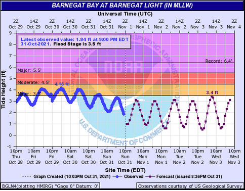 |
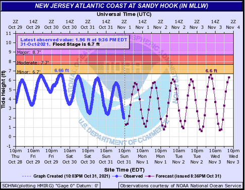
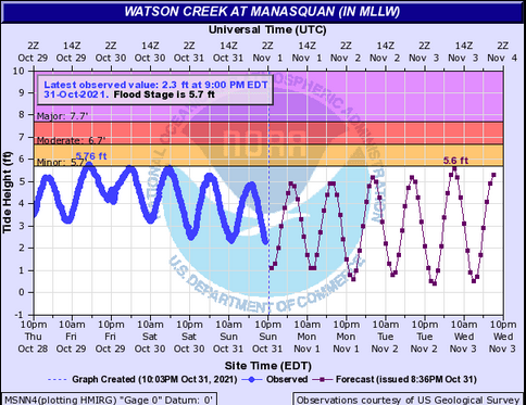
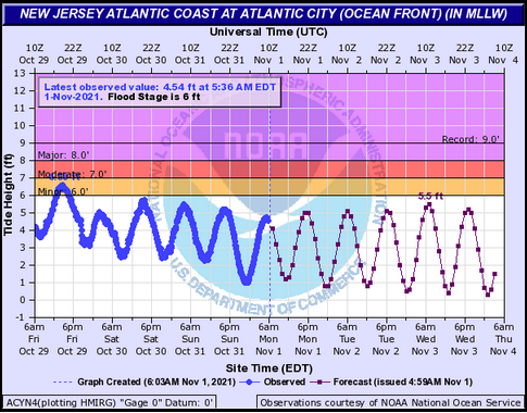
| Figure 1: Hydrograph for the New Jersey Atlantic Coast at Sandy Hook tidal gauge (SDHN4) during the late October 2021 coastal flooding event. The solid blue line represents observed values which have already occurred. The purple line with small square boxes along it represents forecast values. | Figure 2: Same as Fig. 1, for Watson Creek at Manasquan (MSNN4). | Figure 3: Same as Fig. 1, for Barnegat Bay at Barnegat Light (BGLN4). |
 |
 |
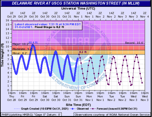 |
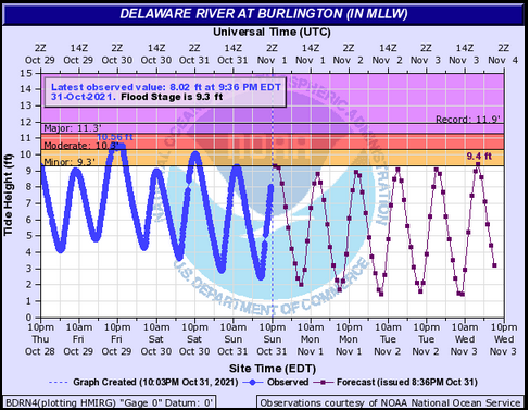
| Figure 4: Same as Fig. 1, for the New Jersey Atlantic Coast at Atlantic City (ACYN4). | Figure 5: Same as Fig. 1, for the tidal Delaware River at Burlington (BDRN4). | Figure 6: Same as Fig. 1, for the tidal Delaware River at USCG Station Washington Street, Philadelphia (PHBP1). |
 |
 |
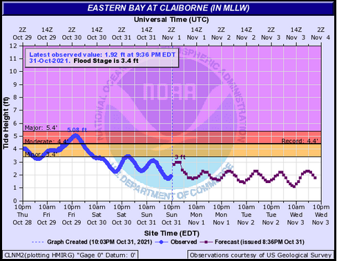 |
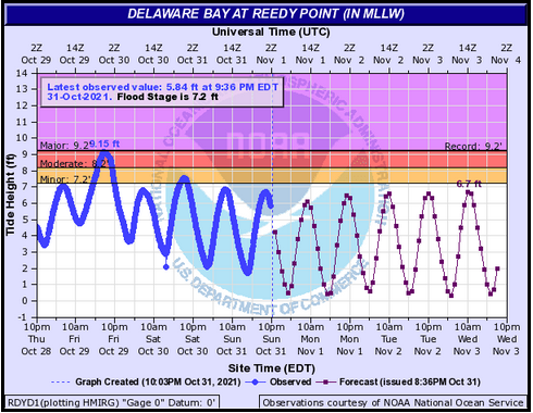
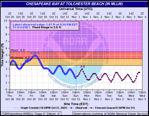
| Figure 7: Same as Fig. 1, for Delaware Bay at Reedy Point (RDYD1). | Figure 8: Same as Fig. 1, for Chesapeake Bay at Tolchester Beach (TCBM2). | Figure 9: Same as Fig. 1, for Eastern Bay at Claiborne (CLNM2). |
Coastal flooding is a common occurrence in the local area. The presence of the Atlantic Ocean and several local bays, inlets, and tidal rivers and tributaries present a constant and complex challenge to forecasters. In some cases, it can take only small deviations, on the order of a few tenths of one foot, from the normal astronomical tide to cause tidal flooding. Tidal flooding is so common that NWS Mount Holly will not issue a Coastal Flood Advisory until forecast water levels exceed three tenths (0.3) of one foot above a tidal gauge’s documented minor flood stage. Coastal Flood Watches and Warnings are reserved for the less common instances of moderate and major tidal flooding.
The late October, 2021 tidal flooding event was notable for a couple of reasons. The synoptic pattern which led to the flooding event was one that is commonly associated with tidal flooding: coastal low pressure leading to a strong and long duration onshore wind event, which pushes large amounts of water towards the coast and local tidal areas, and prevents that water from escaping back out to sea as it does in a normal tidal cycle. However, a couple of abnormalities were present in this case. First, the event occurred during a period of astronomically low tides. Tidal magnitude is primarily governed by the lunar cycle, with astronomical tides reaching their maxima at the times of a full or new moon. In this case, however, the moon was squarely in between a full moon on October 20 and a new moon on October 29. While tidal flooding can and does occur during periods of low astronomical tides, it requires a significantly higher meteorological surge component to compensate. Such a surge, of 3 to 5 feet above astronomical tidal levels, was present in this event. Because of this unusually high surge, it is very fortunate that astronomical tides were not higher, or flooding would have been signifcantly worse.
Also of note, in most of our region’s tidal flooding events, the worst flooding (of the moderate and major variety) is typically found near oceanfront locations, whether it be the New Jersey or Delaware oceanfront itself, or adjacent bays such as Barnegat Bay in New Jersey and Indian River Inlet in Delaware. However, in this event, the worst flooding occurred across upper Delaware Bay, the tidal Delaware River, and Chesapeake Bay, though significant flooding also occurred in some of the back bays of eastern New Jersey. Most tidal gauges near the oceanfront (as seen in the Hydrographs tab on this page) reached only minor flood stage, and in some cases failed to reach flood stage at all. On the other hand, moderate to major flooding occurred in those other aforementioned locations. While areas like the tidal Delaware River and Chesapeake Bay are no strangers to flooding, it is unusual to see this disparity from the oceanfront locations; conversely, it is relatively common for minor to moderate flooding to occur at oceanfront locations while little to no flooding occurs in other tidal areas.
There were a couple of reasons flooding was worse at some of the typically less prone locations. The greater impacts on Chesapeake Bay can partially be explained by the fact that Chesapeake Bay has a naturally lower tidal range than other tidal portions of the area. Thus, the astronomically low tides are less of a factor for determining flooding potential on the Chesapeake. On Delaware Bay and the tidal Delaware River, much of the disparity can be explained by the timing of the highest storm surge versus the time of high tides. Elevated tidal levels were present for several days leading into and during the coastal storm on account of the long duration onshore flow. However, the greatest tidal departures occurred during a concentrated surge in water levels on the evening and overnight of the 29th. This surge coincided with the time of low tide at the oceanfront, sparing those areas from worse flooding. However, the tidal Delaware River and most of Delaware Bay experiences high tide 3 to 6 hours later than local oceanfront locations. Thus, in those areas, the highest surge occurred closer to the time of high tide. In addition, in those locations, the duration of higher surge values lasted longer than at the oceanfront, due to the difficulty in water draining back out to sea from areas like the Delaware River thanks to the continued onshore flow pushing water in despite the falling tides attempting to drag water out.
A pair of images below illustrate this point. These annotated graphs show water levels at the Sandy Hook (Figure 1) and Reedy Point (Figure 2) tidal gauges during the event. In the graph, the blue line “Predictions” simply marks the expected astronomical tide, all other factors aside. The “Predictions” label is somewhat misleading; it is not a forecast made by NWS, it is simply the expected astronomical tide. The green line (labeled as “Verified”) shows the actual water levels which occurred. The purple line represents the difference between the green and blue lines. It can be thought of as the storm surge. Positive values represent times when the actual water levels were higher than the astronomical tide. In this case all the values are positive since water levels were elevated. (Note: there is no data for the red line marked “Preliminary” and users should disregard this.) These images help to show why flooding in locations such as Delaware Bay and the tidal Delaware Bay, areas which Reedy Point is a good representation of, was worse than in oceanfront locations such as Sandy Hook.
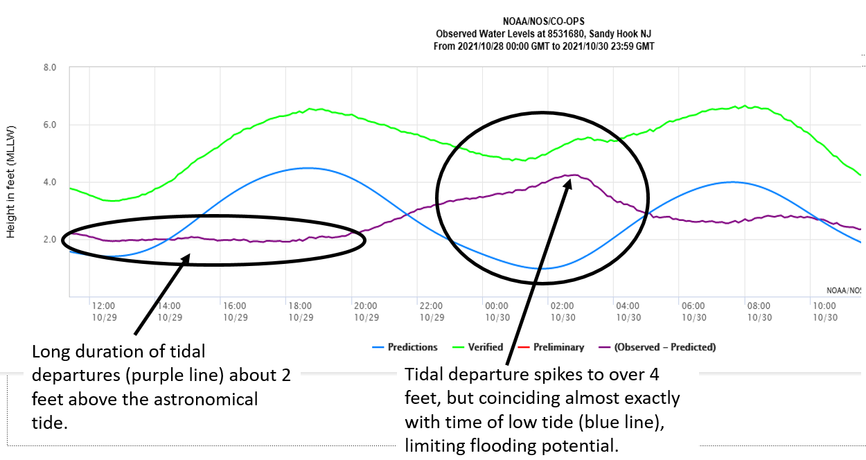 |
| Figure 1: Annotated graph of water levels at the Sandy Hook gauge during the late October 2021 tidal flooding event. |
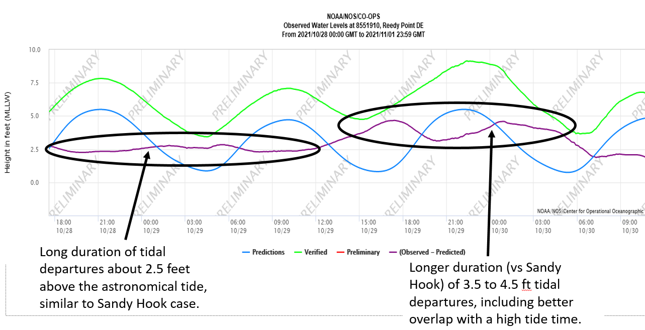 |
| Figure 2: Same as Figure 1, for the Reedy Point gauge. |
This effect also helps to explain why flooding in eastern New Jersey back bay locations was worse than would normally be expected with only minor flooding at the oceanfront tidal gauges. Back bay high tides occur a little later than oceanfront high tides. But more importantly, the especially long duration of onshore flow was a major factor for the back bays in preventing water from draining. While other meteorological and hydrologic factors are involved, these facts explain a large part of the distribution of tidal flooding during the late October 2021 event.
A list of coastal flooding reports and some associated impacts can be found in the Summary LSR tab on this page.


 Coastal Flood
 Marine Forecasts
 Text Products
 Climate Information
 Skywarn
 Submit Storm Report
 Weather Event Archives
 Forecast Discussion
 Emergency Managers
 Briefing Page