
Tropical Storm Bertha could bring tropical storm conditions to portions of the Florida Panhandle and Alabama coast through Wednesday, where a Tropical Storm Watch and Storm Surge Watch is in effect. Numerous severe thunderstorms with heavy rainfall are expected from the Ohio Valley into the Mid-Atlantic and Northeast Tuesday. Read More >
Overview
|
A record warm air mass enveloped the mid-Atlantic on March 7, 2022. Temperatures soared into the 70s and locally near 80 degrees, with many climate sites breaking their daily records. By the evening hours, a strong cold front approached the region, associated with a strengthening area of low pressure tracking through upstate New York and into New England. In a classic cool season severe weather setup, a small amount of instability developed ahead of the front. Combined with very strong wind fields and forcing, a low topped squall line developed just ahead of the front. The squall line moved through eastern Pennsylvania, New Jersey, and Delmarva during the mid to late evening hours on the 7th. As usual in these setups, lightning was limited, but the line produced widespread wind gusts of 50 to 70 mph throughout the area. This led to numerous reports of downed trees and power outages, with tens of thousands of customers at least briefly losing power as the line moved through. Gusty winds also continued behind the front in association with cold air advection following the frontal passage. These winds gradually diminished through the night as the front moved offshore, and a more seasonably cool air mass moved in to follow. |
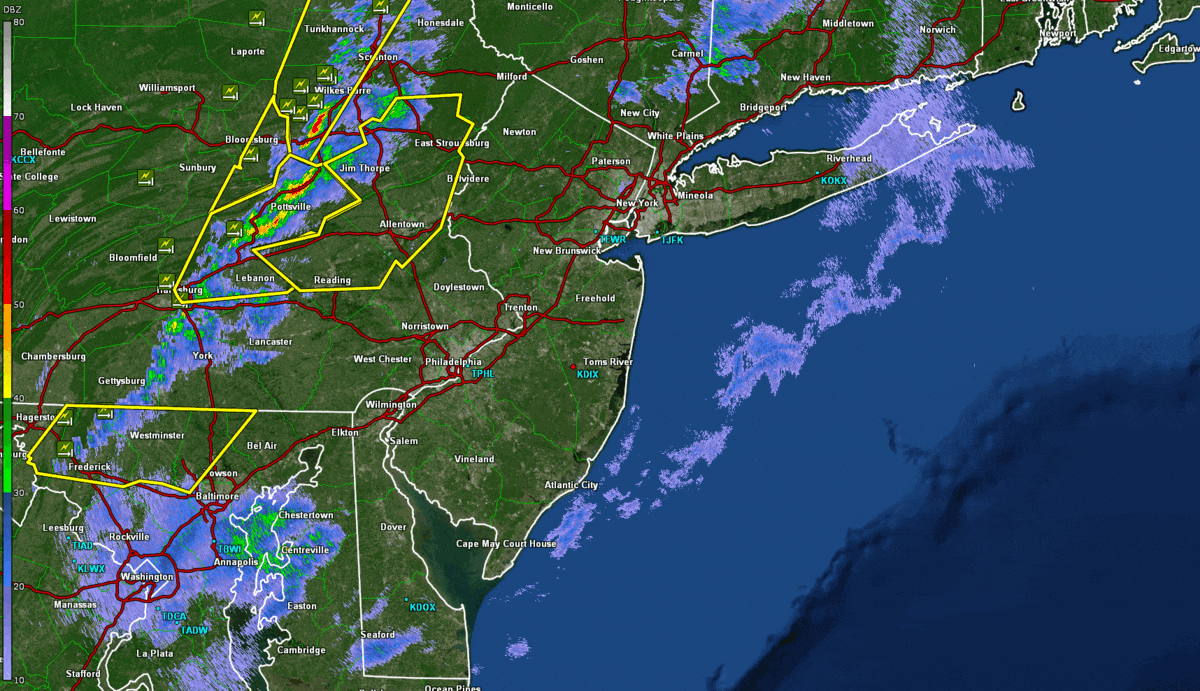 KDIX radar reflectivity at approximately 30 minute intervals from 7:30 PM to 11:30 PM EST March 7, 2022, showing the evolution of the squall line which affected the region. NWS Severe Thunderstorm (yellow), Special Marine (Teal) and Local Storm Reports are overlaid. Click to enlarge. |
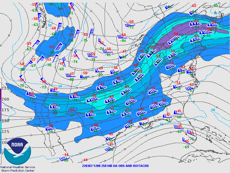
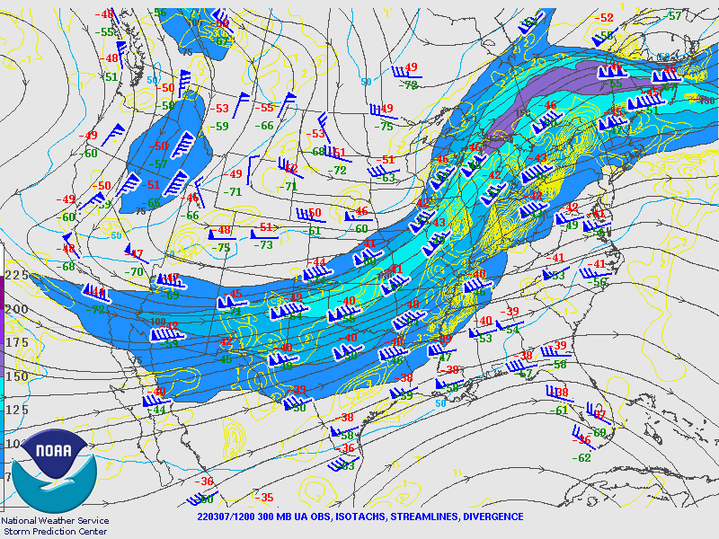
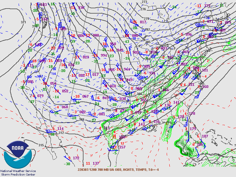
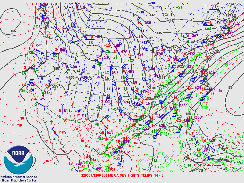
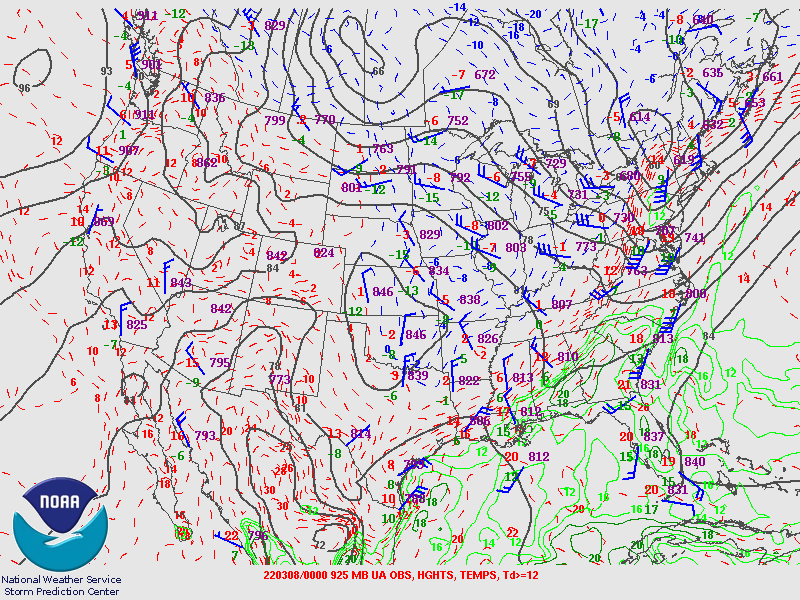
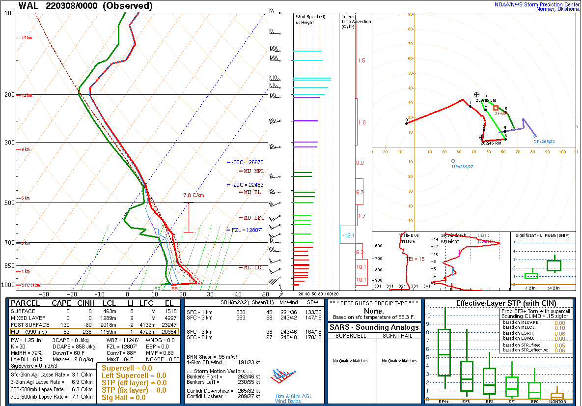
Synoptic Overview at 12z 7 Mar 2022 (courtesy of SPC)
 |
 |
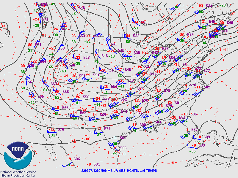 |
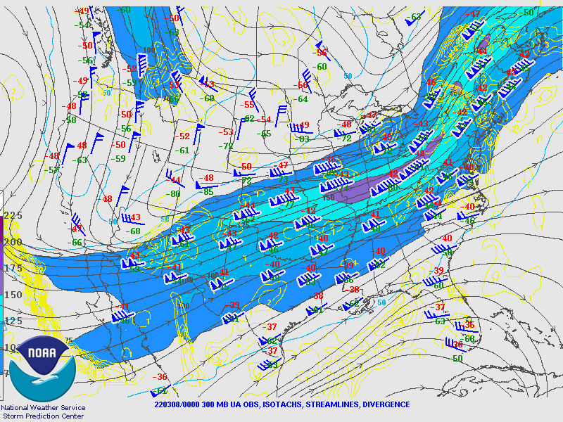
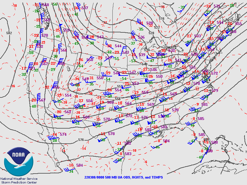
| Figure 1: 250-mb analysis | Figure 2: 300-mb analysis | Figure 3: 500-mb analysis |
 |
 |
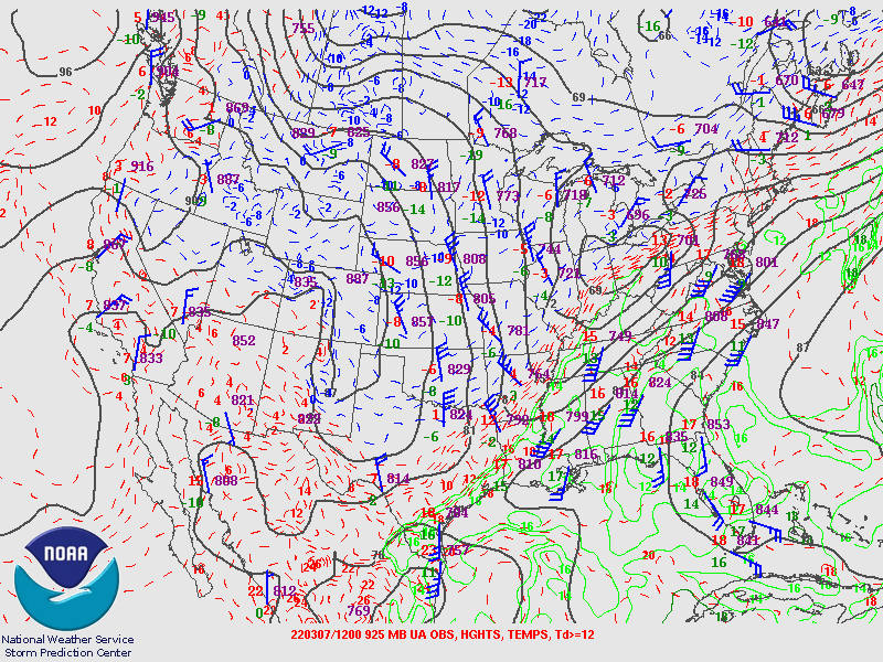 |
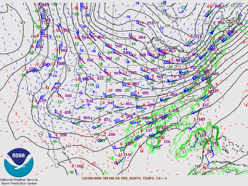
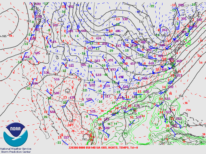
| Figure 4: 700-mb analysis | Figure 5: 850-mb analysis | Figure 6: 925-mb analysis |
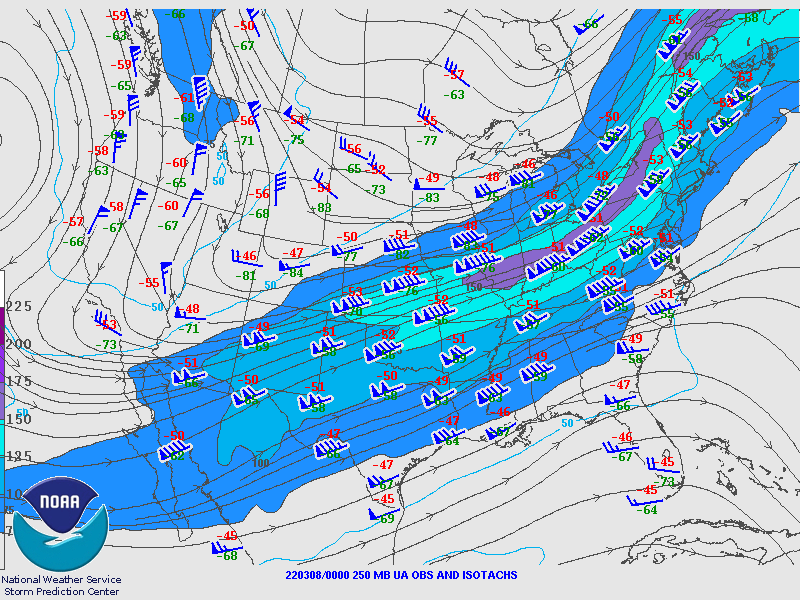
Synoptic Overview at 00z 8 Mar 2022 (courtesy of SPC)
 |
 |
 |
| Figure 7: 250-mb analysis | Figure 8: 300-mb analysis | Figure 9: 500-mb analysis |
 |
 |
 |
| Figure 10: 700-mb analysis | Figure 11: 850-mb analysis | Figure 12: 925-mb analysis |
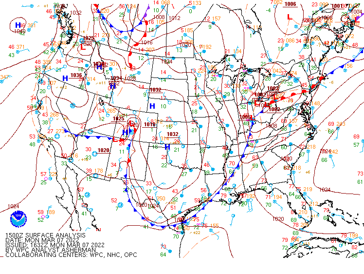
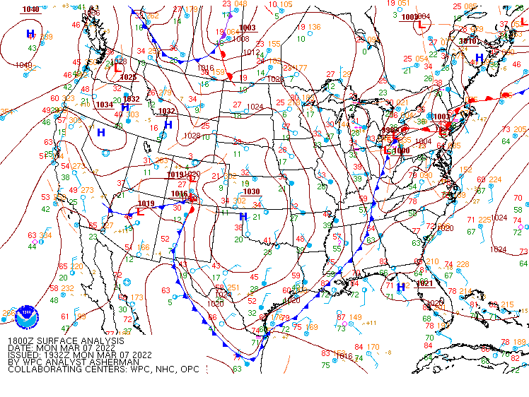
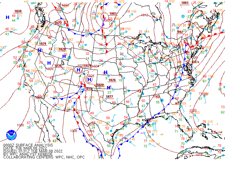
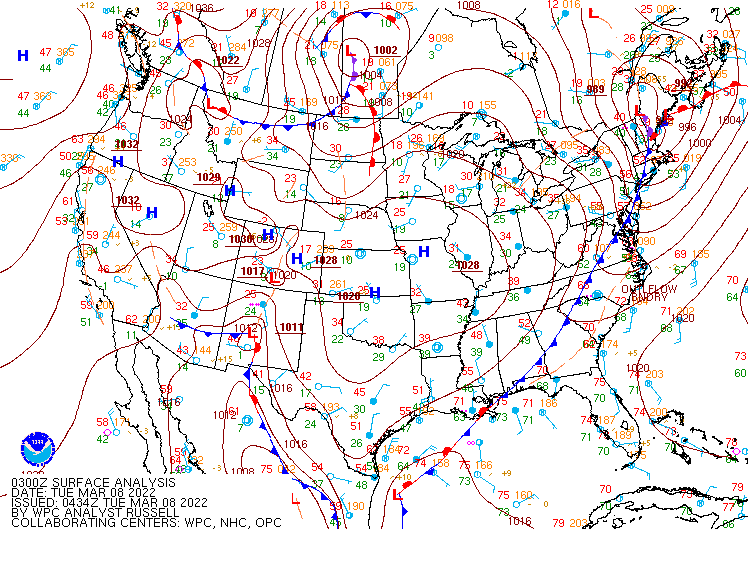
Surface Maps (courtesy of WPC)
 |
 |
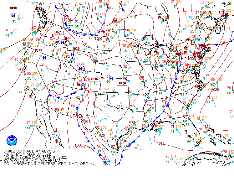 |
| Figure 13: 15z surface map | Figure 14: 18z surface map | Figure 15: 21z surface map |
 |
 |
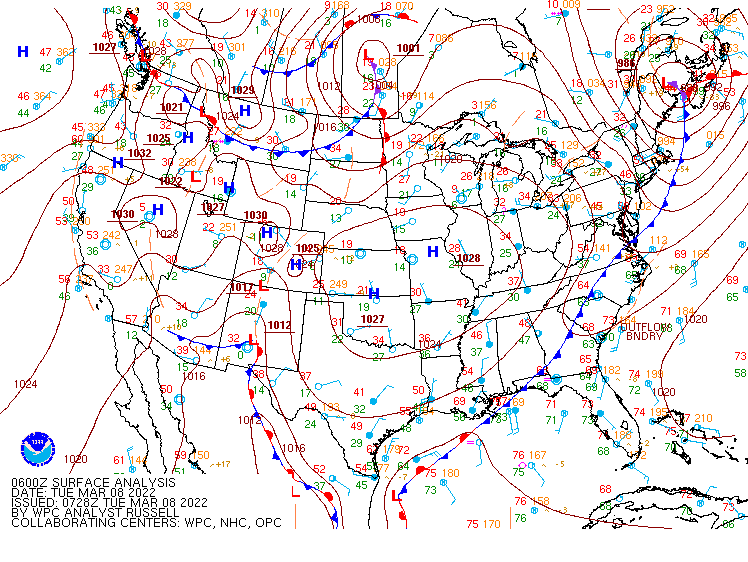 |
| Figure 16: 00z surface map | Figure 17: 03z surface map | Figure 18: 06z surface map |
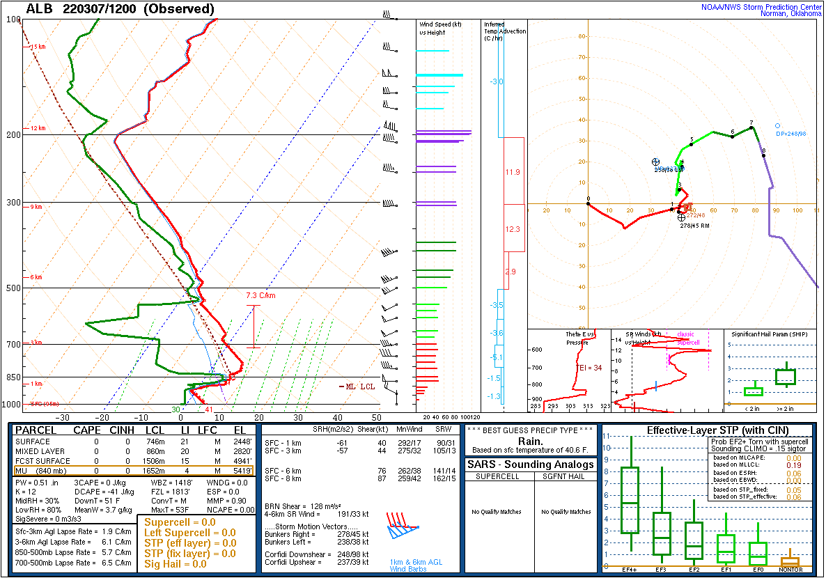 |
 |
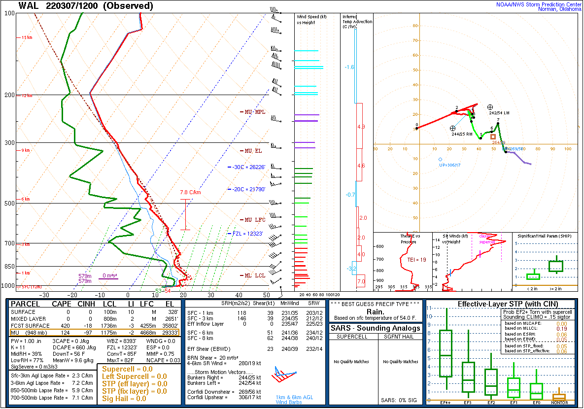 |
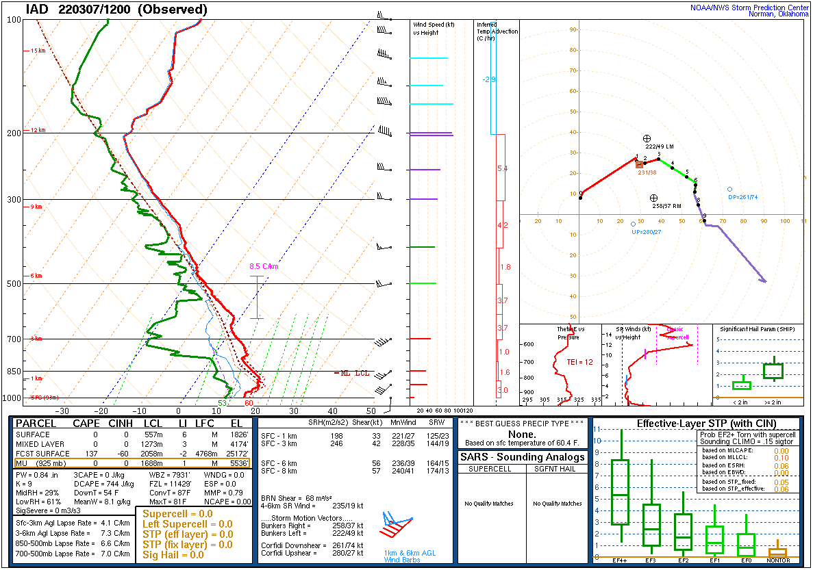
| Figure 19: 12z Albany, NY sounding | Figure 20: 12z Sterling, VA sounding | Figure 21: 12z Wallops Island, VA sounding |
 |
 |
 |
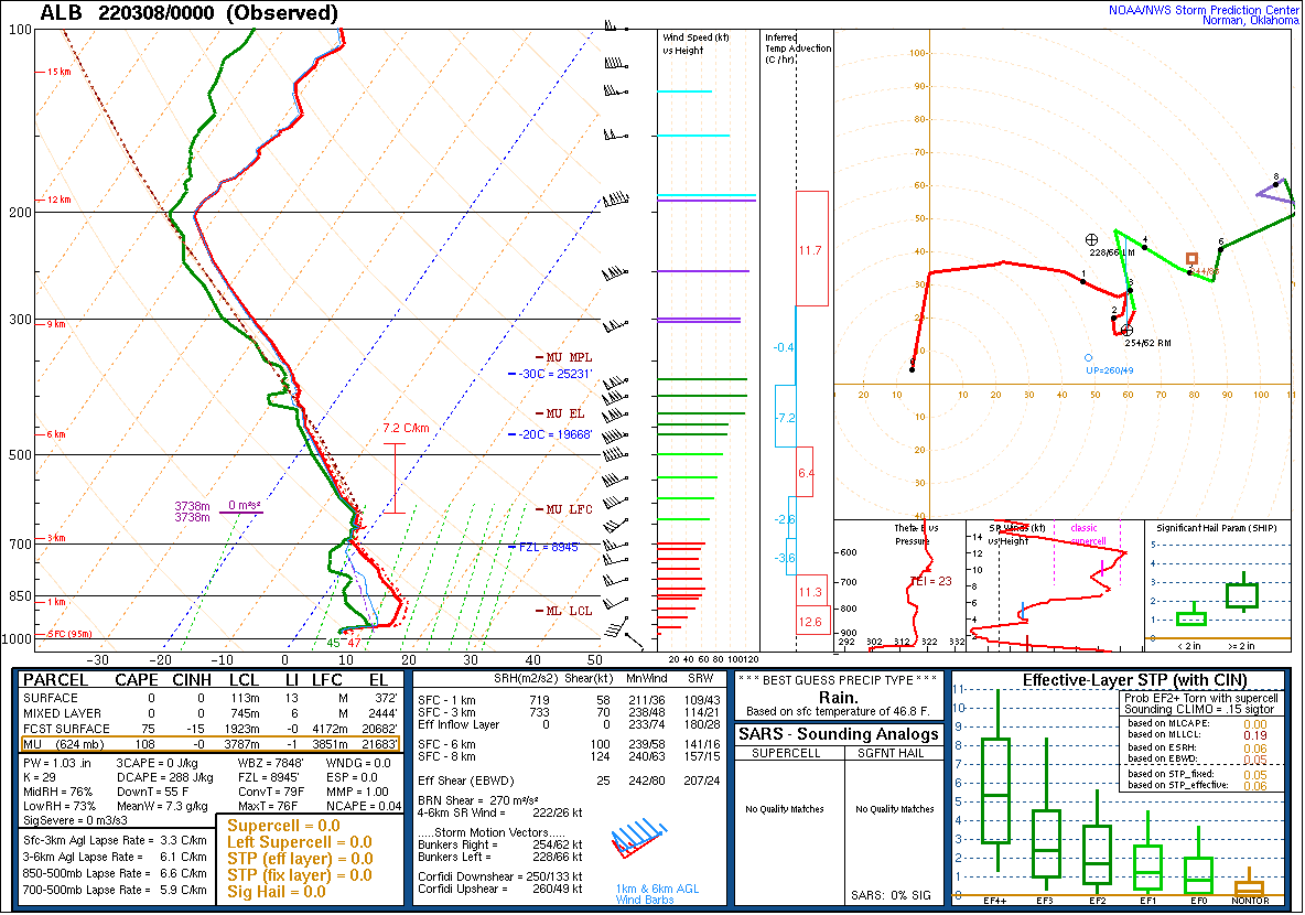
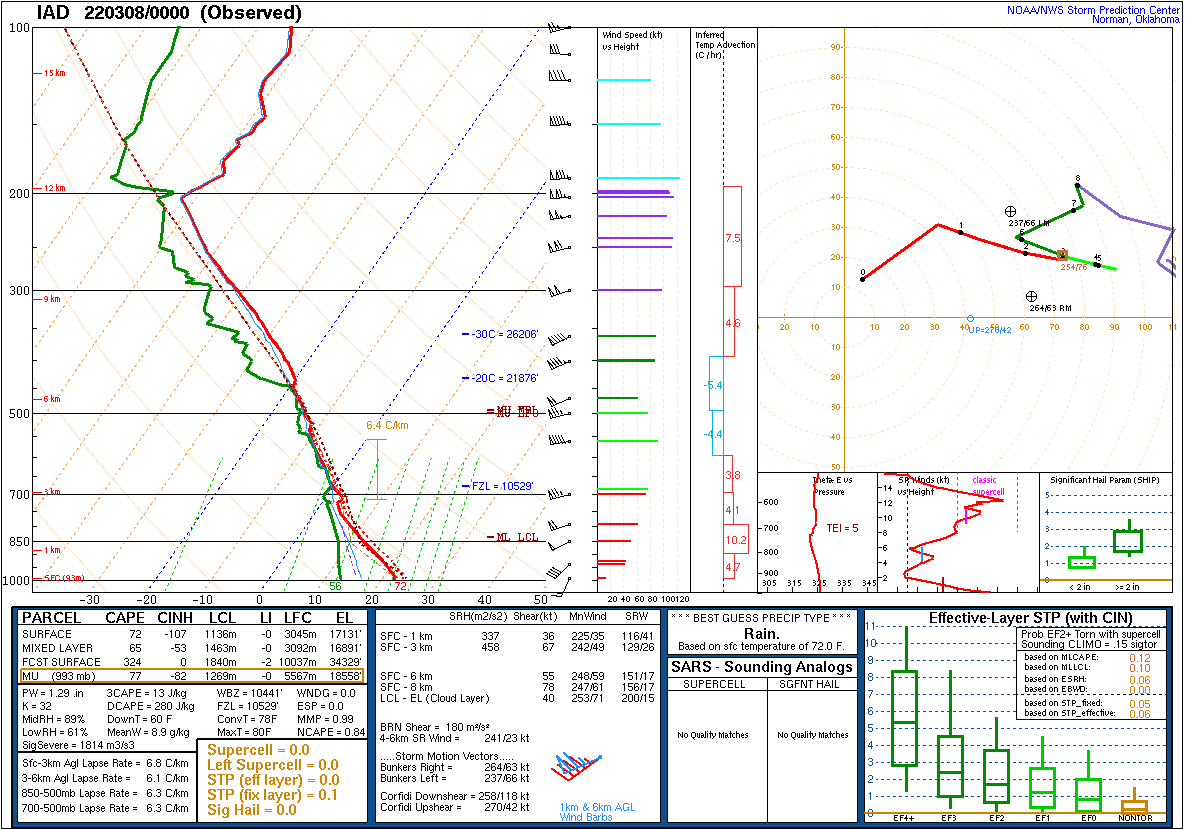
| Figure 22: 00z Albany, NY sounding | Figure 23: 00z Sterling, VA sounding | Figure 24: 00z Wallops Island, VA sounding |
 |
 |
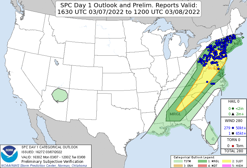 |
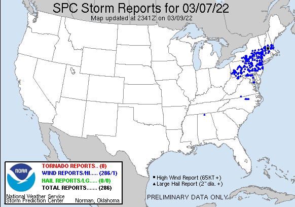
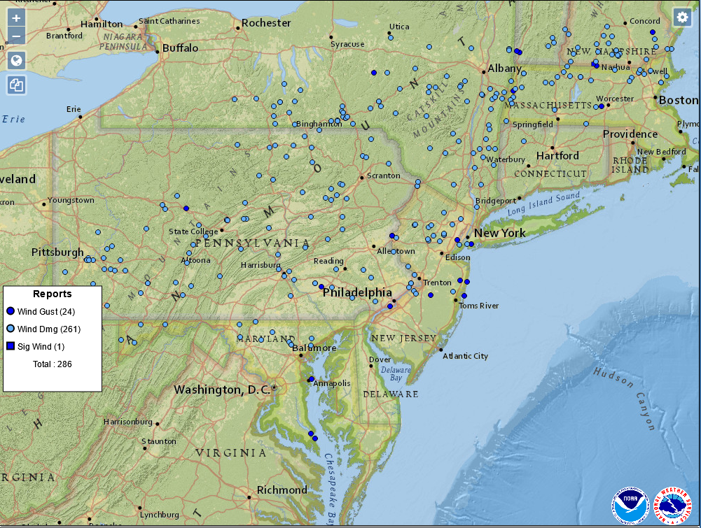
| Figure 1: National Preliminary Reports 12z 7 Mar 2022 to 12z 8 Mar 2022 | Figure 2: Zoomed Preliminary Reports for the same period. | Figure 3: Prelim Reports vs. 1630z SPC Convective Outlook |
Click here for a county warning area based plot of local storm reports and warnings/advisories issued for the 7 Mar 2022 event.
NWUS51 KPHI 080847
LSRPHI

PRELIMINARY LOCAL STORM REPORT...SUMMARY
NATIONAL WEATHER SERVICE MOUNT HOLLY NJ
347 AM EST TUE MAR 8 2022

..TIME...   ...EVENT...      ...CITY LOCATION...     ...LAT.LON...
..DATE...   ....MAG....      ..COUNTY LOCATION..ST.. ...SOURCE....
            ..REMARKS..

0806 PM     TSTM WND DMG     1 ENE WERNERSVILLE      40.33N 76.07W
03/07/2022                   BERKS              PA   PUBLIC

            1 INCH TREE LIMBS BROKEN; SHINGLES BLOWN
            OFF.

0826 PM     TSTM WND GST     FORKS TWP               40.73N 75.19W
03/07/2022  M66 MPH          NORTHAMPTON        PA   TRAINED SPOTTER

            POWER KNOCKED OUT.

0830 PM     TSTM WND GST     FORKS TWP               40.73N 75.19W
03/07/2022  E60 MPH          NORTHAMPTON        PA   PUBLIC

            DOWNED TREE; TREE KNOCKED OVER FULL SIZE
            METAL BASKETBALL HOOP STAND.

0843 PM     TSTM WND DMG     3 NW TRAPPE             40.23N 75.52W
03/07/2022                   MONTGOMERY         PA   PUBLIC

            TREE REPORTED DOWN IN LIMERICK, PA.

0844 PM     TSTM WND DMG     1 WNW HACKETTSTOWN      40.85N 74.84W
03/07/2022                   WARREN             NJ   TRAINED SPOTTER

            DOWNED TREE ON POWER LINES. TIME ESTIMATED
            FROM RADAR.

0844 PM     TSTM WND DMG     1 N HACKETTSTOWN        40.86N 74.83W
03/07/2022                   WARREN             NJ   TRAINED SPOTTER

            DOWN TREE ON POWER LINES ON 6TH STREET. TIME
            ESTIMATED FROM RADAR.

0844 PM     TSTM WND DMG     HACKETTSTOWN            40.86N 74.83W
03/07/2022                   WARREN             NJ   TRAINED SPOTTER

            TREES DOWN ON TWO CARS. TIME ESTIMATED FROM
            RADAR.

0845 PM     TSTM WND DMG     NOCKAMIXON TWP          40.54N 75.17W
03/07/2022                   BUCKS              PA   PUBLIC

            WIRES DOWN ON MARIENSTEIN ROAD.

0850 PM     TSTM WND GST     SKIPPACK TWP            40.23N 75.41W
03/07/2022  M56 MPH          MONTGOMERY         PA   TRAINED SPOTTER

            PENNY SIZE HAIL.

0857 PM     TSTM WND DMG     1 NW STEWARTSVILLE      40.70N 75.12W
03/07/2022                   WARREN             NJ   PUBLIC

            DOWNED TREE AND DOWNED WIRES ON NJ 57 BOTH
            DIRECTIONS OF CR 637 / LIBERTY ROAD.

0858 PM     TSTM WND DMG     KINNELON                41.00N 74.38W
03/07/2022                   MORRIS             NJ   PUBLIC

            TREE BLOWN DOWN AND KNOCKED OUT TRANSFORMER.

0859 PM     TSTM WND GST     DOYLESTOWN AIRPORT      40.33N 75.12W
03/07/2022  M54 MPH          BUCKS              PA   ASOS


0900 PM     TSTM WND DMG     1 SSE LAMBERTVILLE      40.36N 74.94W
03/07/2022                   HUNTERDON          NJ   PUBLIC

            DOWNED TREE ON NJ 29 NORTHBOUND SOUTH OF
            WEEDEN ST (LAMBERTVILLE).

0900 PM     TSTM WND DMG     2 NNE BASKING RIDGE     40.73N 74.54W
03/07/2022                   MORRIS             NJ   DEPT OF HIGHWAYS

            DOWNED TREE ON I-287 SOUTHBOUND NORTH OF
            EXIT 30 - NORTH MAPLE AVE (HARDING TWP).

0900 PM     TSTM WND GST     CHATHAM                 40.74N 74.38W
03/07/2022  M62 MPH          MORRIS             NJ   PUBLIC


0900 PM     TSTM WND DMG     CHATHAM                 40.74N 74.38W
03/07/2022                   MORRIS             NJ   PUBLIC

            MULTIPLE TREE LIMBS DOWN ON ROADWAYS. VIA
            SOCIAL MEDIA.

0905 PM     TSTM WND DMG     1 NNE CHATHAM           40.75N 74.38W
03/07/2022                   MORRIS             NJ   TRAINED SPOTTER

            SNAPPED TREES AND BRANCHES IN AREA. ONE
            NEIGHBOR HAD A TREE UPROOTED AND ANOTHER HAD
            A LIMB FALL ON THEIR HOME. TIME ESTIMATED
            FROM RADAR.

0906 PM     TSTM WND DMG     1 SE FAR HILLS          40.67N 74.62W
03/07/2022                   SOMERSET           NJ   DEPT OF HIGHWAYS

            DOWNED TREE ON I-287 NORTHBOUND NORTH OF
            EXIT 22 - US 202 (FAR HILLS).

0911 PM     TSTM WND DMG     1 NE FAR HILLS          40.69N 74.63W
03/07/2022                   SOMERSET           NJ   DEPT OF HIGHWAYS

            DOWNED TREE ON US 202 BOTH DIRECTIONS NORTH
            OF CR 512 / SUNNYBRANCH ROAD.

0913 PM     TSTM WND DMG     RANDOLPH                40.85N 74.57W
03/07/2022                   MORRIS             NJ   PUBLIC

            BASKETBALL HOOP BLOWN OVER (ESTIMATED WEIGHT
            OF 200 LBS ON THE BASE); POWER OUT.

0914 PM     TSTM WND GST     BUTLER                  41.00N 74.34W
03/07/2022  M52 MPH          MORRIS             NJ   PUBLIC


0920 PM     TSTM WND DMG     LEVITTOWN               40.16N 74.89W
03/07/2022                   BUCKS              PA   PUBLIC

            SEVERAL TREES AND WIRES DOWN ACROSS LOWER
            BUCKS COUNTY. TIMES ESTIMATED FROM RADAR.

0920 PM     TSTM WND DMG     2 WSW TRENTON MERCER AI 40.26N 74.84W
03/07/2022                   MERCER             NJ   DEPT OF HIGHWAYS

            DOWNED TREE ON I-295 NORTHBOUND SOUTH OF
            EXIT 76 - NJ 29 (EWING TWP).

0920 PM     TSTM WND DMG     BENSALEM                40.11N 74.93W
03/07/2022                   BUCKS              PA   TRAINED SPOTTER

            PART OF ROOF SIDING TORN OFF.

0922 PM     TSTM WND GST     LEVITTOWN               40.16N 74.89W
03/07/2022  M68 MPH          BUCKS              PA   PUBLIC

            MEASURED ON A PERSONAL ANEMOMETER.

0925 PM     TSTM WND GST     PHILADELPHIA INTERNATIO 39.88N 75.22W
03/07/2022  M67 MPH          PHILADELPHIA       PA   OTHER FEDERAL


0930 PM     TSTM WND DMG     BURLINGTON              40.07N 74.85W
03/07/2022                   BURLINGTON         NJ   DEPT OF HIGHWAYS

            DOWNED TREE ON US 130 NORTHBOUND SOUTH OF CR
            670 / JACKSONVILLE ROAD.

0935 PM     TSTM WND GST     1 WNW SOUTH JERSEY REGI 39.94N 74.86W
03/07/2022  E50 MPH          BURLINGTON         NJ   NWS EMPLOYEE

            DAVIS INSTRUMENT MEASURED 37 MPH BUT IS
            BLOCKED BY TREES; ESTIMATED MAXIMUM WINDS AT
            LOCATION 50 MPH.

0946 PM     TSTM WND GST     2 E FORT DIX            40.02N 74.59W
03/07/2022  M60 MPH          BURLINGTON         NJ   AWOS

            MCGUIRE AFB.

0957 PM     TSTM WND GST     3 ESE FARMINGDALE       40.19N 74.12W
03/07/2022  M59 MPH          MONMOUTH           NJ   AWOS

            MONMOUTH EXECUTIVE AIRPORT.

1000 PM     TSTM WND DMG     2 SSW LAKEWOOD TWP      40.06N 74.23W
03/07/2022                   OCEAN              NJ   TRAINED SPOTTER

            LARGE TREE BLOWN OVER ONTO TWO VEHICLES ON
            CROSS STREET. TIME ESTIMATED FROM RADAR.

1003 PM     TSTM WND GST     HOWELL                  40.16N 74.22W
03/07/2022  E55 MPH          MONMOUTH           NJ   PUBLIC

            WINDS ESTIMATED TO BE BETWEEN 50 AND 60 MPH.

1014 PM     TSTM WND GST     BELMAR                  40.18N 74.02W
03/07/2022  M59 MPH          MONMOUTH           NJ   PUBLIC

            REPORT VIA SOCIAL MEDIA.

1020 PM     MARINE TSTM WIND 2 SSW MANTOLOKING       40.01N 74.06W
03/07/2022  M61 MPH          OCEAN              NJ   MESONET


1029 PM     MARINE TSTM WIND 2 E WARETOWN            39.79N 74.17W
03/07/2022  M48 MPH          ANZ451             NJ   MESONET


&&

$$
NOUS41 KPHI 081911
PNSPHI
DEZ001>004-MDZ012-015-019-020-NJZ001-007>010-012>027-PAZ054-055-060>062-070-
071-101>106-090711-

Public Information Statement
National Weather Service Mount Holly NJ
211 PM EST Tue Mar 8 2022

...HIGHEST WIND REPORTS FROM MARCH 7, 2022...

Location                     Speed     Time/Date       Provider

...Delaware...

...Kent County...
Dover                        53 MPH    0156 PM 03/07   AWOS
St. Jones River Dover        37 MPH    0210 PM 03/07   DEOS2
St. Jones River Kitts Hummoc 36 MPH    0220 PM 03/07   DEOS2

...Sussex County...
Lewes NOS                    40 MPH    0212 PM 03/07   NOS-NWLON
Selbyville                   38 MPH    0315 PM 03/07   CWOP
Broad Creek Laurel           35 MPH    0210 PM 03/07   DEOS2
Lewes DE-University          35 MPH    0315 PM 03/07   DEOS2
Rehoboth Bay Milton          33 MPH    0200 PM 03/07   DEOS2

...New Jersey...

...Atlantic County...
Pleasantville Point          30 MPH    0217 PM 03/07   WXFLOW

...Burlington County...
2 E Fort Dix                 60 MPH    0946 PM 03/07   AWOS
1 WNW South Jersey Regional  50 MPH    0935 PM 03/07   NWS Employee
Lumberton                    33 MPH    0310 PM 03/07   CWOP

...Gloucester County...
Logan Twp.                   39 MPH    0320 PM 03/07   NJWXNET
Mickleton                    33 MPH    0159 PM 03/07   CWOP

...Hunterdon County...
Ringoes                      31 MPH    0219 PM 03/07   CWOP

...Mercer County...
Ewing                        34 MPH    0230 PM 03/07   CWOP

...Middlesex County...
Perth Amboy                  54 MPH    0233 PM 03/07   WXFLOW
Carteret                     35 MPH    0205 PM 03/07   CWOP
New Brunswick                35 MPH    0215 PM 03/07   NJWXNET
Edison                       32 MPH    0245 PM 03/07   CWOP

...Monmouth County...
3 ESE Farmingdale            59 MPH    0957 PM 03/07   AWOS
Belmar                       59 MPH    1014 PM 03/07   Public
Howell                       55 MPH    1003 PM 03/07   Public
1 SW Long Branch             43 MPH    0955 PM 03/07   CO-OP Observer
Keyport                      37 MPH    0300 PM 03/07   CWOP
Holmdel                      31 MPH    0305 PM 03/07   NJWXNET

...Morris County...
Chatham                      62 MPH    0900 PM 03/07   Public
Butler                       52 MPH    0914 PM 03/07   Public

...Ocean County...
Trixies                      34 MPH    0239 PM 03/07   WXFLOW
Beach Haven                  33 MPH    0206 PM 03/07   CWOP
Brick                        33 MPH    0231 PM 03/07   CWOP
Seaside Heights              33 MPH    0247 PM 03/07   WXFLOW
Mantoloking                  31 MPH    0240 PM 03/07   WXFLOW
Brick                        30 MPH    0250 PM 03/07   CWOP

...Pennsylvania...

...Berks County...
Fleetwood                    42 MPH    0245 PM 03/07   CWOP
Reading                      37 MPH    0223 PM 03/07   ASOS
Mertztown                    31 MPH    0245 PM 03/07   CWOP

...Bucks County...
Levittown                    68 MPH    0922 PM 03/07   Public
Doylestown Airport           54 MPH    0859 PM 03/07   ASOS
Newbold NOS                  43 MPH    0230 PM 03/07   NOS-PORTS
Newtown                      37 MPH    0255 PM 03/07   CWOP

...Delaware County...
Thornton                     37 MPH    0249 PM 03/07   CWOP

...Lehigh County...
Trexler                      34 MPH    0243 PM 03/07   RAWS
Lehigh Valley Intl Airport   33 MPH    0231 PM 03/07   ASOS

...Montgomery County...
Skippack Twp                 56 MPH    0850 PM 03/07   Trained Spotter

...Northampton County...
Forks Twp                    66 MPH    0826 PM 03/07   Trained Spotter
Forks Twp                    60 MPH    0830 PM 03/07   Public
Nazareth                     37 MPH    0230 PM 03/07   CWOP

...Philadelphia County...
Philadelphia International A 67 MPH    0925 PM 03/07   Other Federal
&&
Notable Radar Imagery (AWIPS)
 |
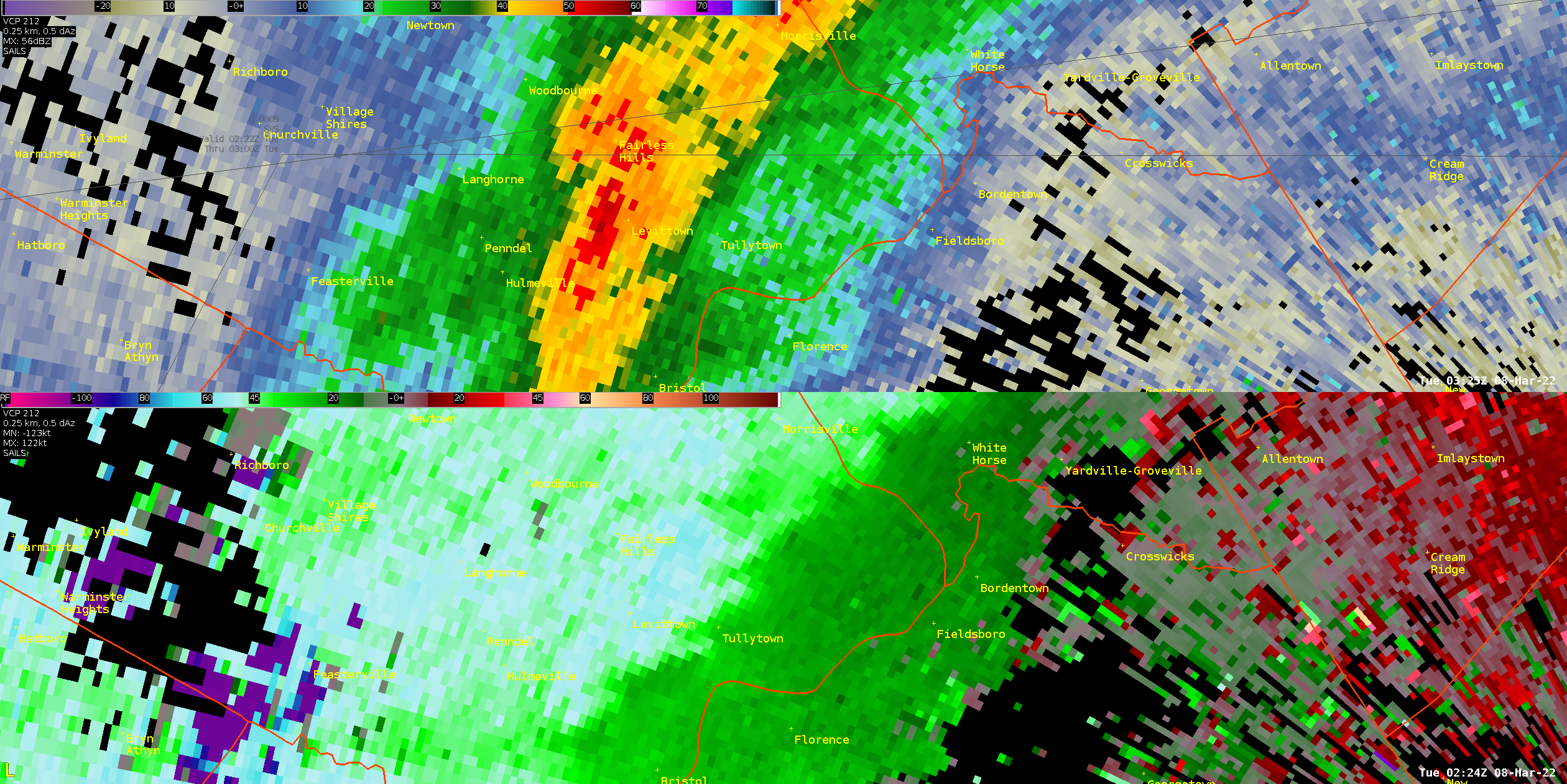 |
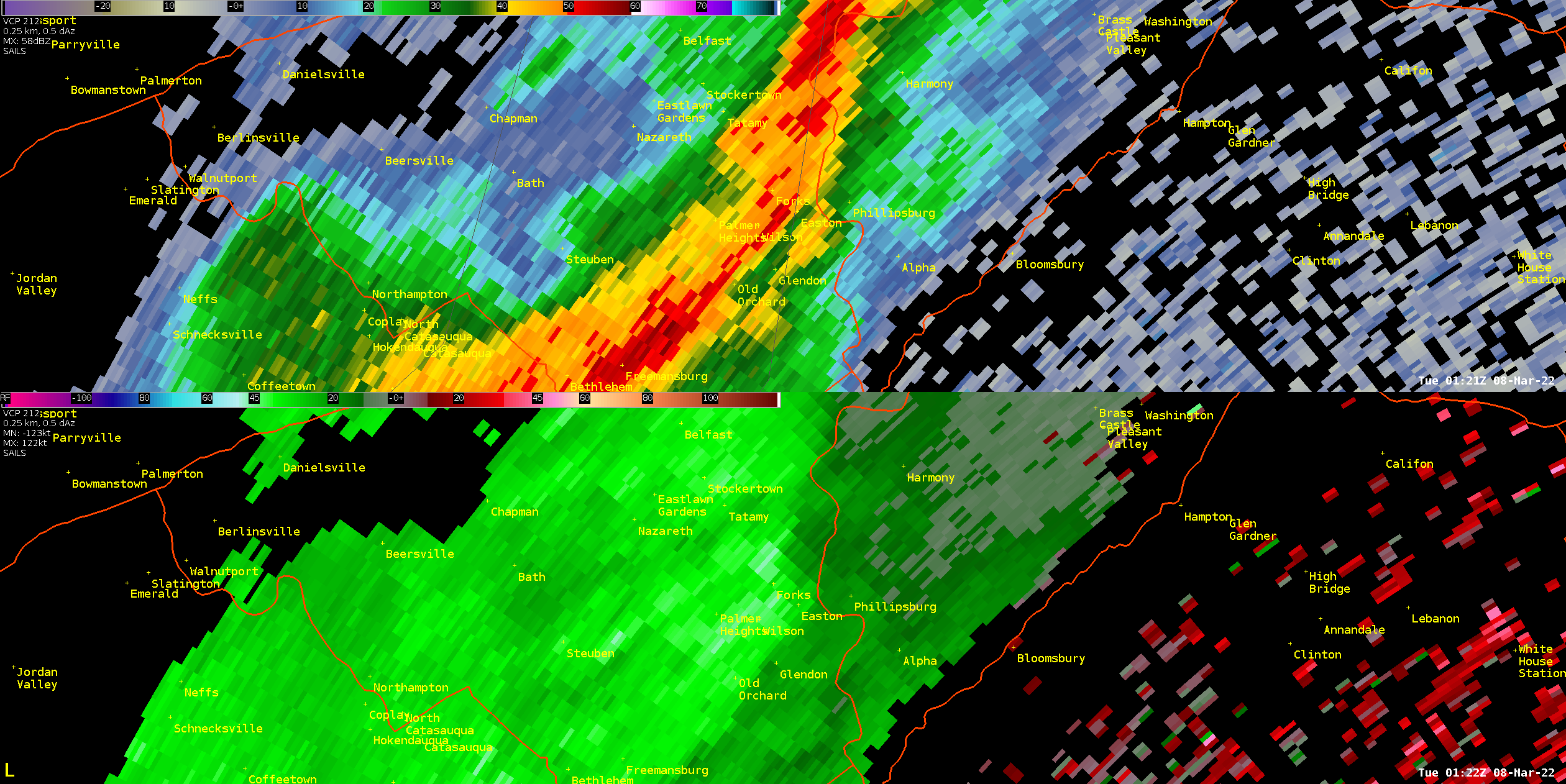
| Figure 1: KDIX radar reflectivity (top) and base velocity (bottom) for the 0.5 degree elevation angle valid at 0121 UTC 8 March 2022. A segment of the squall line is seen. Two wind gusts at or above 60 mph were reported from Forks Twp, PA. The radar imagery indicates somewhat of a bowing structure as well as enhanced velocities in the area of Forks Twp, which supports the enhanced gusts recorded in that area. | Figure 2: Same as Figure 1, valid 0224 UTC. A 68 mph wind gust was reported in Levittown, PA. Once again, reflectivity and velocity data support the idea that enhanced wind values were likely to occur in that area, with a large area of inbound velocities of 50 to 60 kt seen in what appears to be a rear inflow jet feature. |
 |
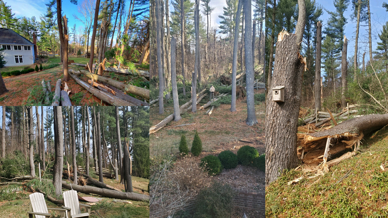 |
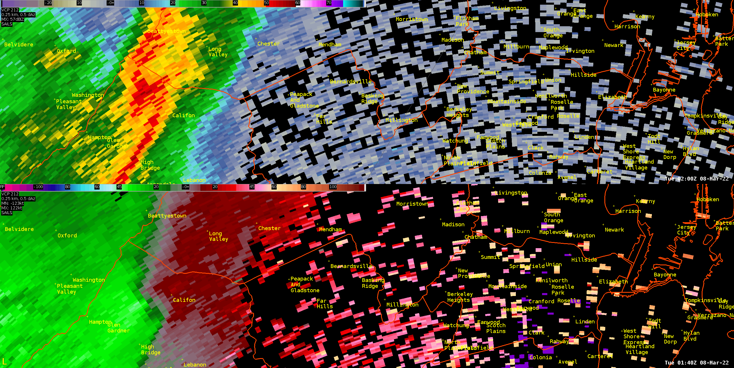
| Figure 3: Same as Figure 1, looped from 0145 to 0200 UTC 8 March 2022. The most interesting radar signature of the night occurred in northern Somerset County, NJ, in the area of Peapack and Gladstone and Bernardsville. The segment of the squall line which produced the strong winds in Forks Twp moved into this area about half an hour later. The radar loop reveals significant structural changes as the line moved through this area. Specifically, the reflectivity data shows the development of a classic “broken S” signature, and the velocity data shows clear indication of some rotation, though it appears to remain fairly broad. Broken S signatures have been connected to damaging tornadic and non-tornadic thunderstorms mainly associated with QLCS events like this (see papers by McAvoy et al., Grumm and Glazewski, Reinoso-Rondinel et al.) Significant tree damage was reported in the area of Peapack and Gladstone (see Figure 4). The radar data at least leaves open the possibility that a brief tornado occurred in this area. However, it is inconclusive, and the damage pattern seen was generally more indicative of straight line winds, so this has been designated a straight line wind event with estimated wind speeds up to 90 mph. | Figure 4: Tree damage in Peapack Gladstone (all on or around the same property) produced by the storm seen in Figure 3. Multiple medium to large size trees are snapped, corresponding to wind speeds around 80 to 90 mph. The pattern of damage is generally characteristic of straight line wind damage. Other reports of tree and utility damage were received from the surrounding area. Photos courtesy of the Somerset County Office of Emergency Management and Bernardsville Police Department. |
 |
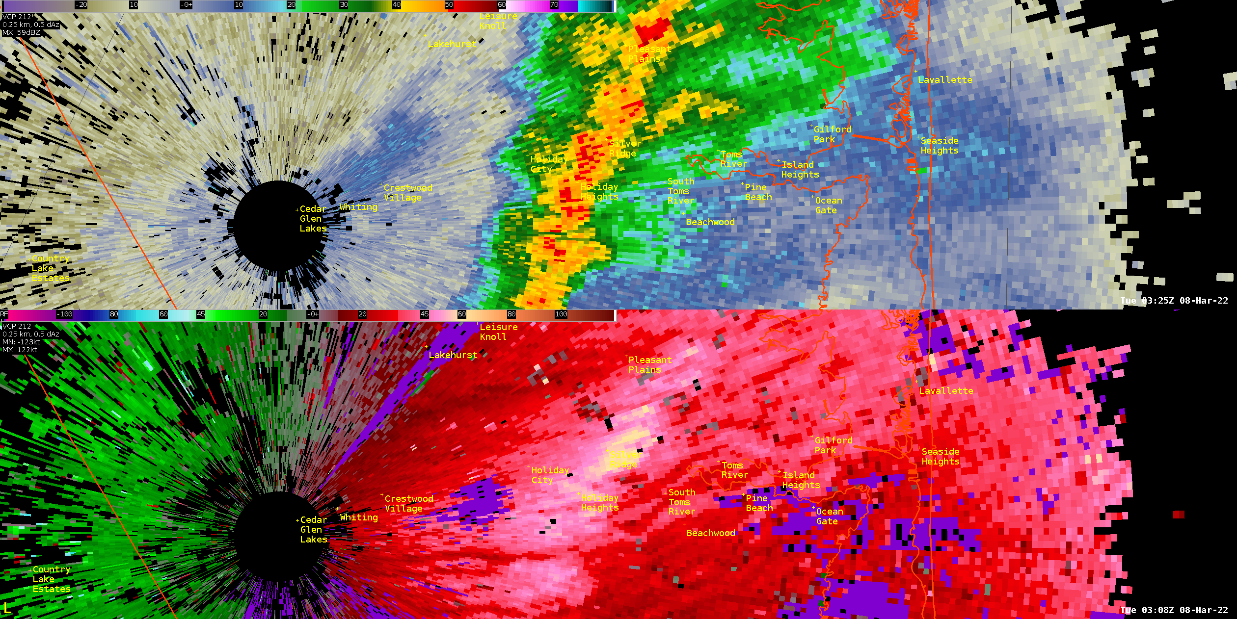 |
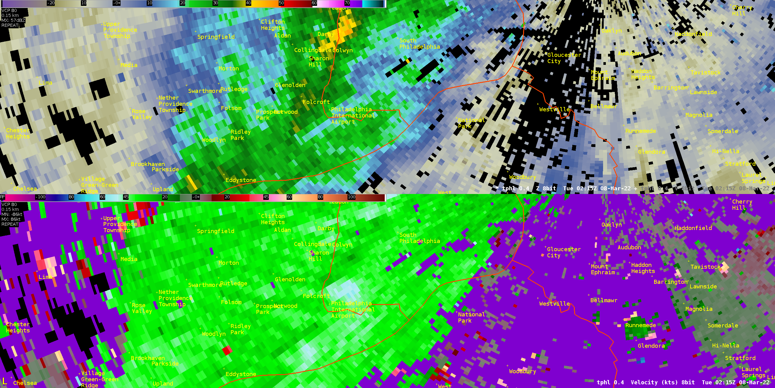
| Figure 5: TPHL radar reflectivity (top) and base velocity (bottom) for the 0.4 degree elevation angle valid 0215 UTC 8 March 2022. An FAA wind sensor at Philadelphia International Airport measured a 67 mph wind gust as the squall line moved over the airport. Reflectivity values were less impressive further south along the line (though the low values seen here are partially a result of the limitations of TDWR radars). However, velocity values remained strong, and severe wind gusts were even produced further south on Delmarva where very little in the way of precipitation fell as the line moved through. | Figure 6: Same as Figure 1, valid 0308 UTC March 8. The squall line continued to produce strong winds as it approached the coast. By this point, the line has moved past the KDIX radar, and the strong velocities now appear as red (outbound) values. A velocity maximum of 60 to 70 kt at just a few hundred feet above the ground can be seen west of Toms River, NJ. |
NOUS41 KPHI 161200
PNSPHI
NJZ009-010-170000-

Public Information Statement
National Weather Service Mount Holly NJ
800 AM EDT Wed Mar 16 2022

...NWS Damage Survey for 03/07/2022 Thunderstorm Wind Event -
Update #1...

.Update...Update to include wind damage from Northern
Hunterdon County, and adjusted the start time and location of
the Somerset County damage.

On Monday evening, March 7, 2022, a narrow convective line
crossed through the region producing considerable wind damage.
Significant damage occurred in northern Hunterdon and Somerset
Counties under the velocity maximum of this line.

.Glen Gardner Thunderstorm Wind...

Peak Wind /Estimated/:  80-90 mph
Path Length /statute/:  0.3 miles
Path Width /maximum/:   100 yards
Fatalities:             0
Injuries:               0

Start Date:             March 07 2022
Start Time:             08:35 PM EST
Start Location:         Glen Gardner
Start Lat/Lon:          40.7039 / -74.9450

End Date:               March 07 2022
End Time:               08:36 PM EST
End Location:           Glen Gardner
End Lat/Lon:            40.7064 / -74.9419

Along Bell Avenue, there was a path of significant tree damage
across multiple properties. Several trees were uprooted and a few
softwood trees were snapped. Trees fell on electrical wires
causing damage to a nearby residence. Tree damage continued in a
path towards the railroad tracks at Bell Avenue.


.Peapack-Gladstone to Bernardsville Thunderstorm Wind...

Peak Wind /Estimated/:  80-90 mph
Path Length /statute/:  5.4 miles
Path Width /maximum/:   200 yards
Fatalities:             0
Injuries:               0

Start Date:             March 07 2022
Start Time:             08:47 PM EST
Start Location:         1 WSW Gladstone
Start Lat/Lon:          40.7190 / -74.6790

End Date:               March 07 2022
End Time:               08:55 PM EST
End Location:           2 N Bernardsville
End Lat/Lon:            40.7400 / -74.5790

Starting near Fowler Road and Highway 206, there was a path of
tree and wire damage up to a few hundred yards wide. Along
Sheephill Drive in Peapack-Gladstone, several large pine trees
were snapped. The tree trunks were fallen in a uniform direction
indicating a narrow path of enhanced wind speeds. Along this same
path, damage was noted at various locations in Bernardsville.
A wooden power pole was snapped, as well as several trees uprooted
and at least one other tree snapped. Path of the worst damage was
narrow, but there was widespread other tree damage across this
area.

The National Weather Service would like to thank Emergency
Management in Somerset and Hunterdon Counties, the borough of
Peapack and Gladstone, Bernardsville Police Department, and
members of the general public for their assistance with this
survey.


&&

NOTE:
The information in this statement is preliminary and subject to
change pending final review of the events and publication in NWS
Storm Data.

$$

Johnson/AKL


 Coastal Flood
 Marine Forecasts
 Text Products
 Climate Information
 Skywarn
 Submit Storm Report
 Weather Event Archives
 Forecast Discussion
 Emergency Managers
 Briefing Page