
Dangerous heat will expand from the Gulf Coast into the Southern Plains and Desert Southwest through week's end. Additional extreme heat impacting the Pacific Northwest will shift to the northern Plains by the weekend. Tropical Storm Bertha is expected to continue to impact portions of the northern Gulf Coast from the western Florida Panhandle to southeastern Louisiana through tonight. Read More >
Overview
|
|* Insert Text Here*| |
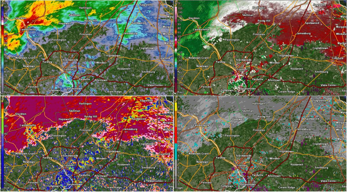 KDIX radar loop from 3:14pm through 4:08pm EDT showing the development of the Mercer County Tornado. The tornado reached a peak intensity of EF2. |
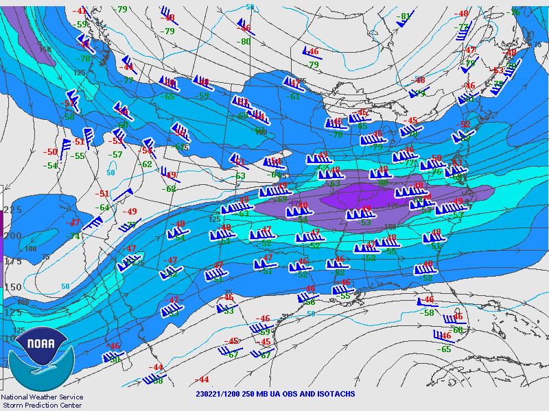
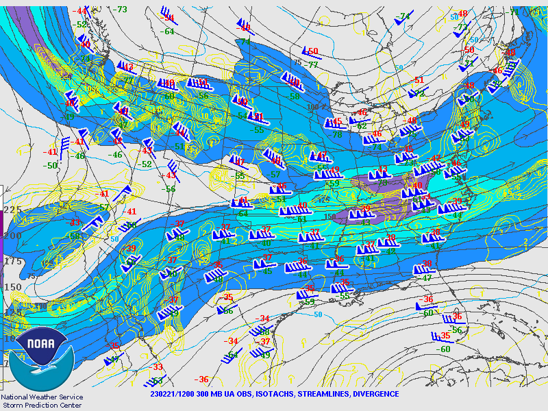
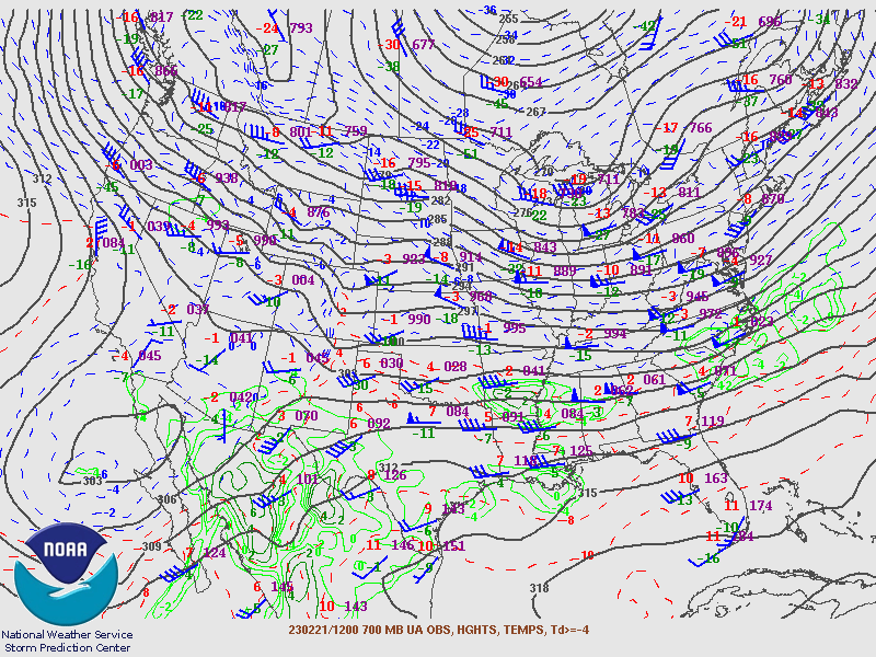
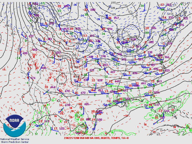
Synoptic Overview at 12z 21 Feb 2023 (courtesy of SPC)
 |
 |
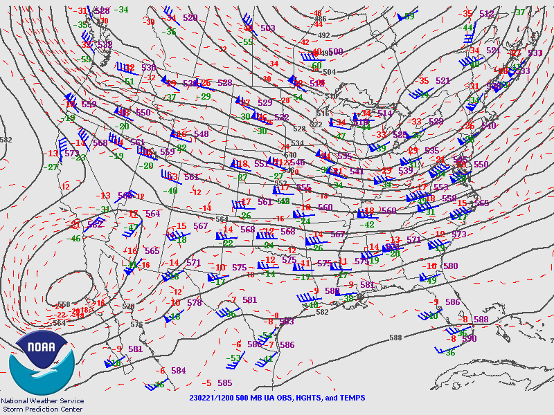 |
| Figure 1: 250-mb analysis | Figure 2: 300-mb analysis | Figure 3: 500-mb analysis |
 |
 |
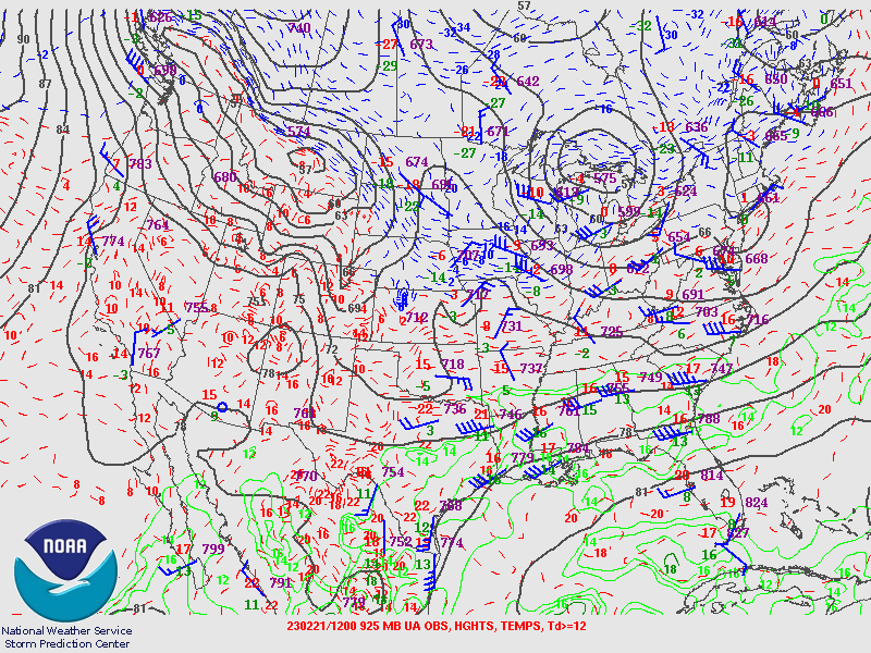 |
| Figure 4: 700-mb analysis | Figure 5: 850-mb analysis | Figure 6: 925-mb analysis |
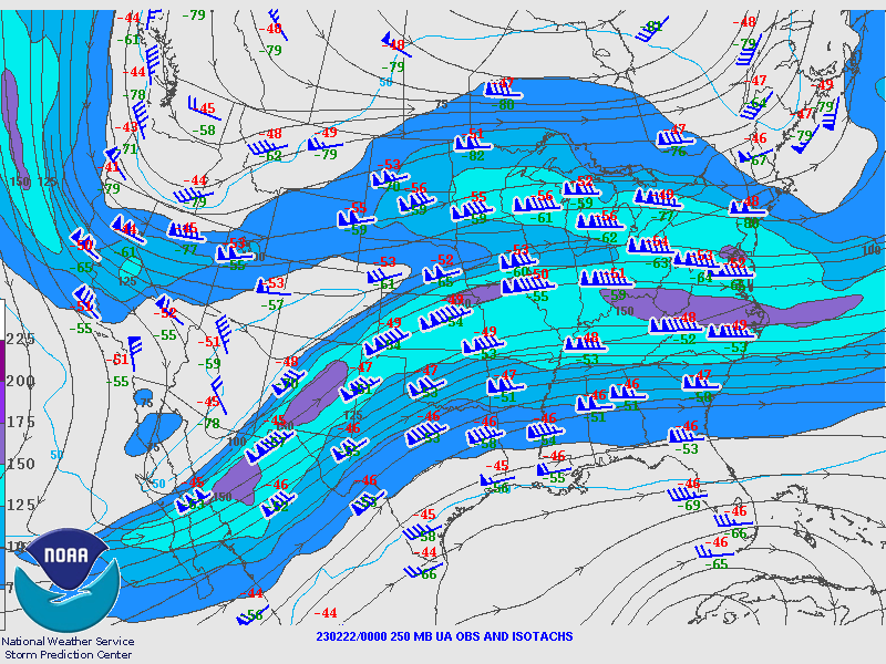
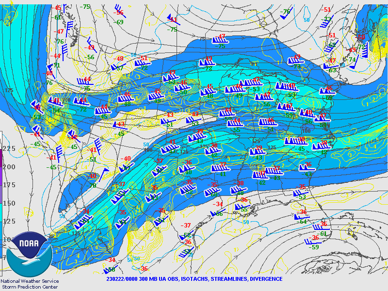
Synoptic Overview at 00z 22 Feb 2023 (courtesy of SPC)
 |
 |
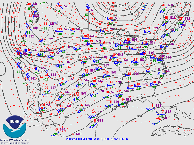 |
| Figure 7: 250-mb analysis | Figure 8: 300-mb analysis | Figure 9: 500-mb analysis |
 |
 |
 |
| Figure 10: 700-mb analysis | Figure 11: 850-mb analysis | Figure 12: 925-mb analysis |
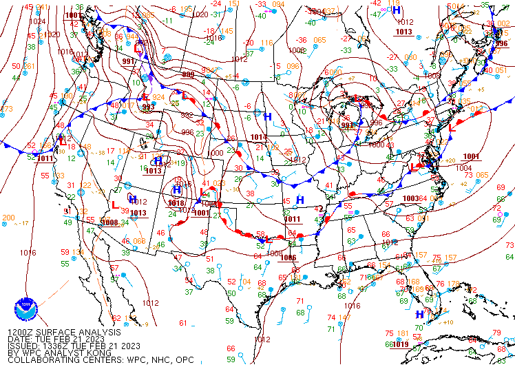
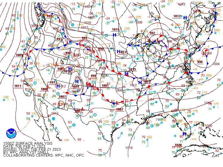
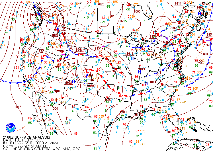
Surface Maps (courtesy of WPC)
 |
 |
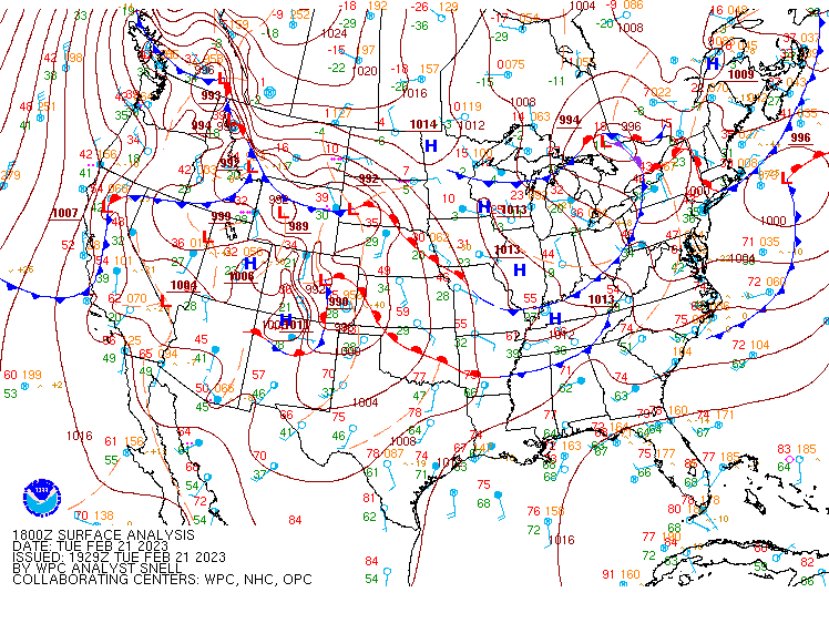 |
| Figure 13: 12z surface map | Figure 14: 15z surface map | Figure 15: 18z surface map |
 |
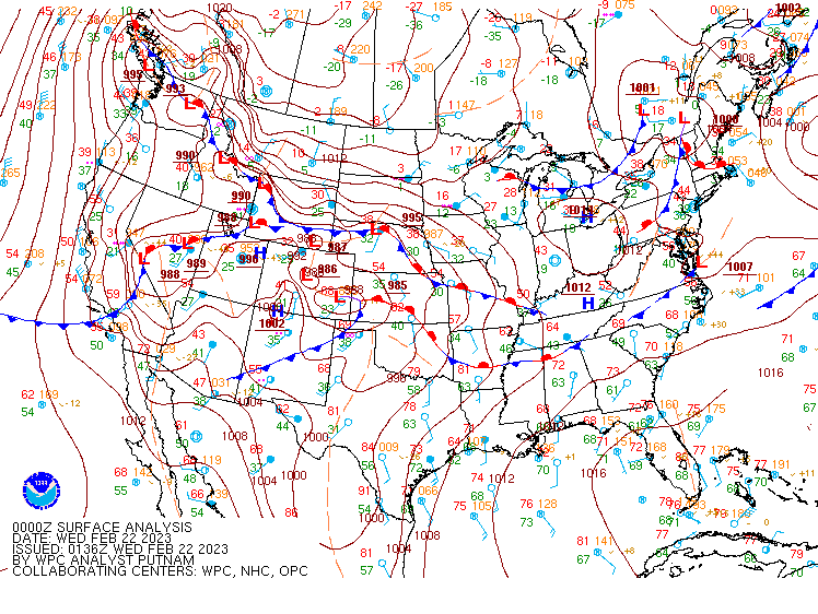 |
| Figure 16: 21z surface map | Figure 17: 00z surface map |
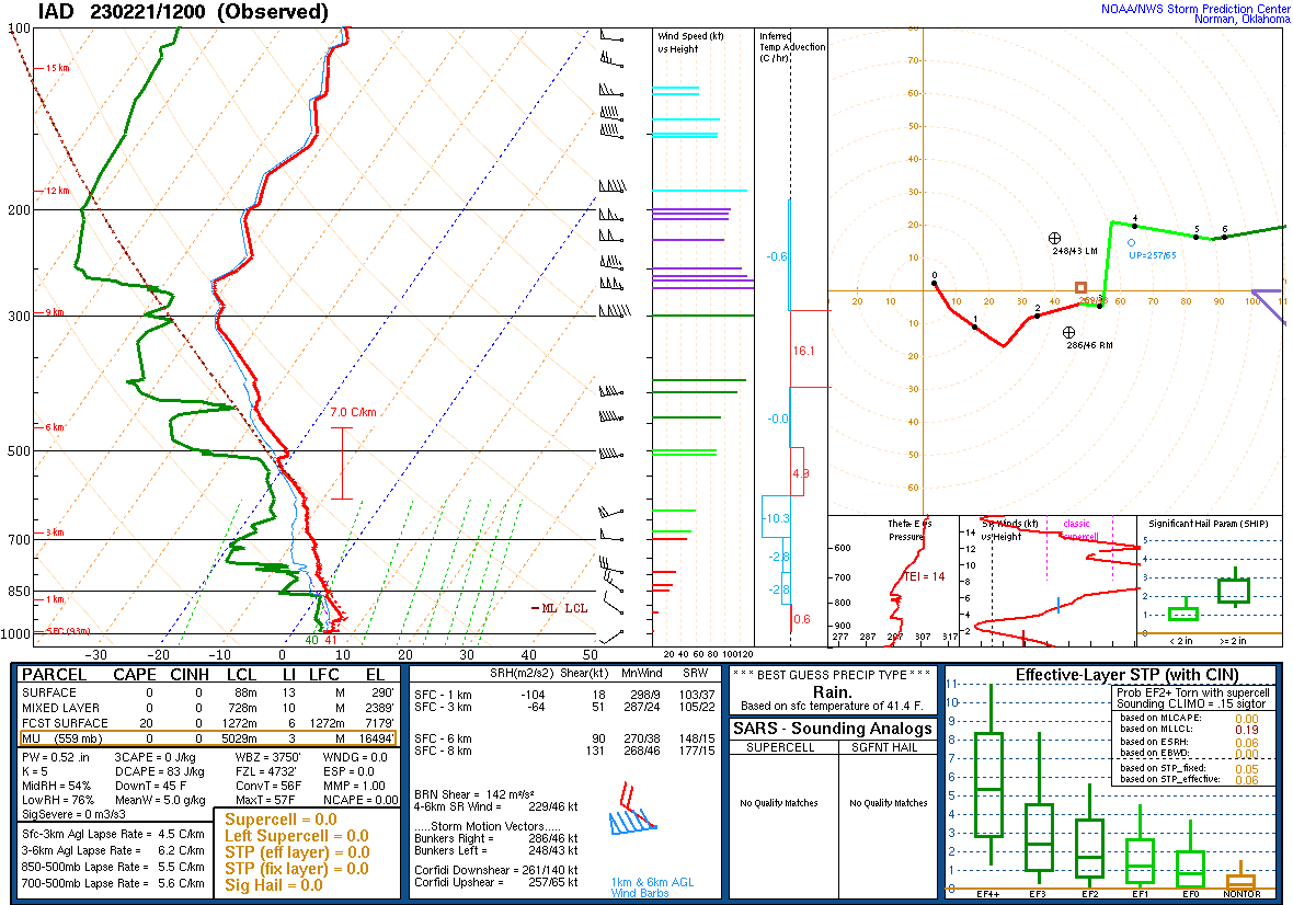
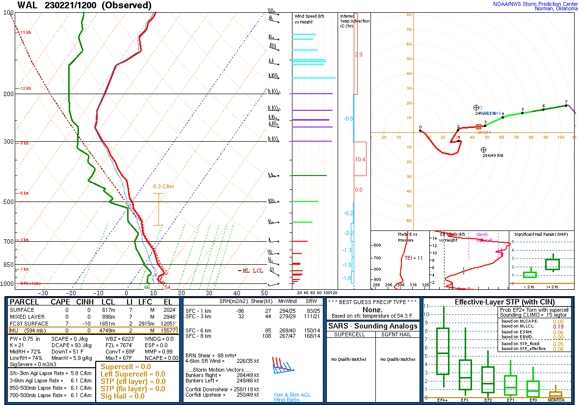
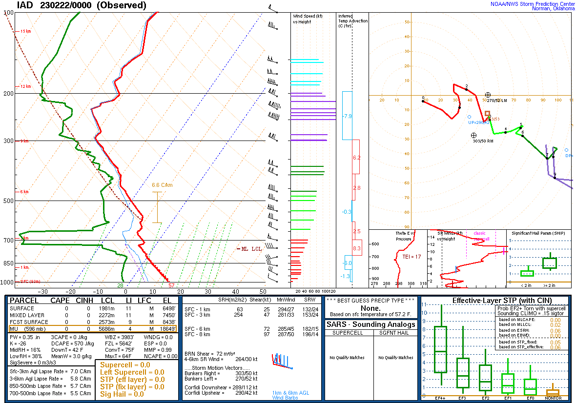
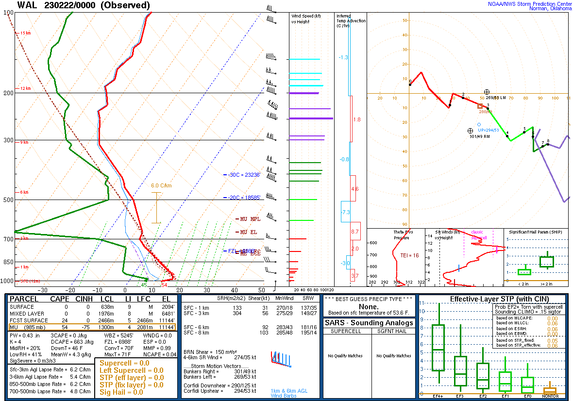
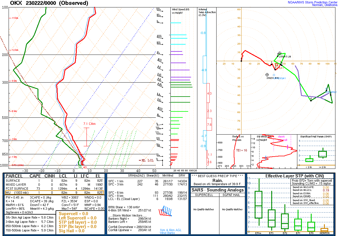
Observed and Forecast Soundings
 |
 |
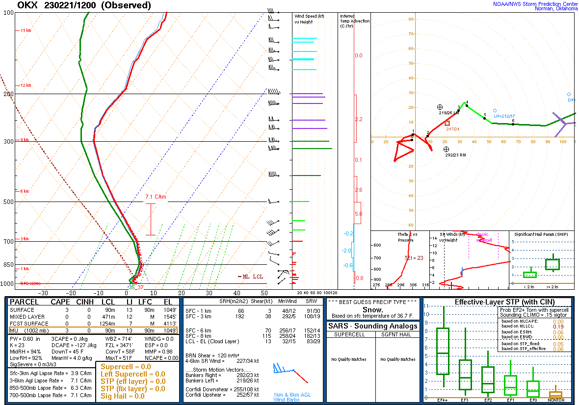 |
| Figure 18: 12z Sterling, VA sounding | Figure 19: 12z Wallops Island, VA sounding | Figure 20: 12z Upton, NY sounding |
 |
 |
 |
| Figure 21: 00z Sterling, VA sounding | Figure 22: 00z Wallops Island, VA sounding | Figure 23: 00z Upton, NY sounding |
 |
 |
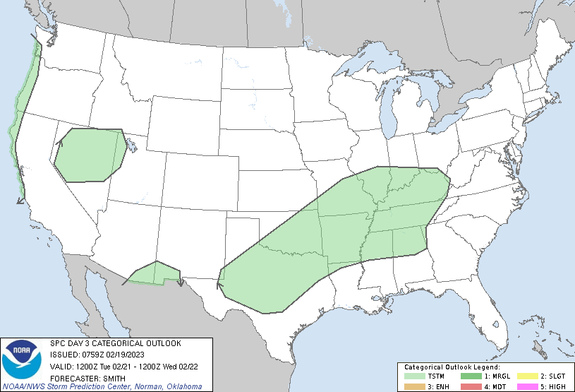 |
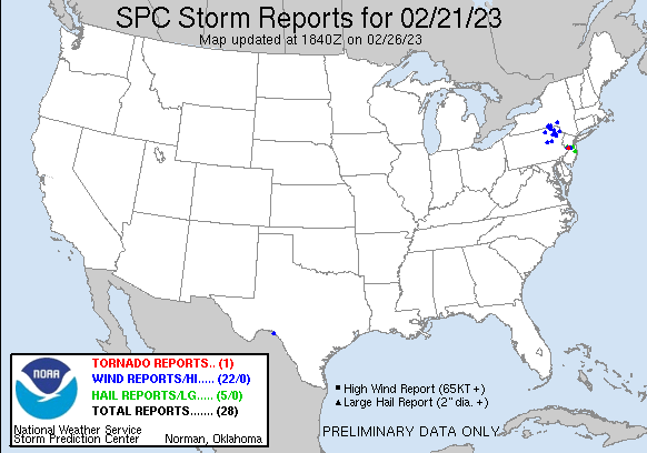
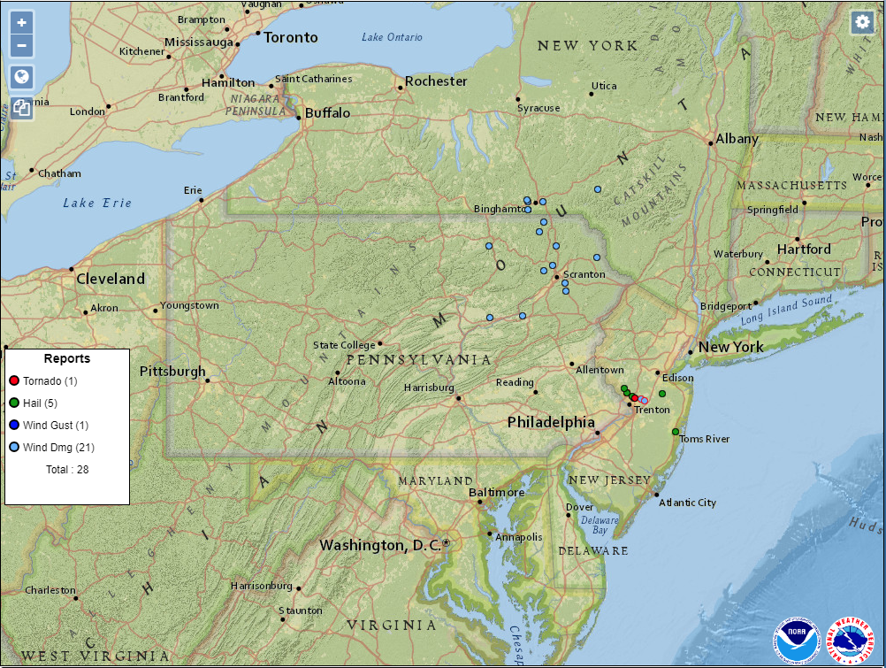
| Figure 1: National Preliminary Reports 12z 21 Feb 2023 to 12z 22 Feb 2023 | Figure 2: Zoomed Preliminary Reports for the same period. | Figure 3: Evolution of SPC outlooks leading into this event, beginning with an initial indication of severe weather potential on the Day 4 outlook for Feb 21. |
 |
Click here for a county warning area zoomable archive of the warnings/advisories issued for the 21 Feb 2023 event. |
NWUS51 KPHI 220302
LSRPHI

PRELIMINARY LOCAL STORM REPORT...SUMMARY
NATIONAL WEATHER SERVICE MOUNT HOLLY NJ
1002 PM EST TUE FEB 21 2023

..TIME...   ...EVENT...      ...CITY LOCATION...     ...LAT.LON...
..DATE...   ....MAG....      ..COUNTY LOCATION..ST.. ...SOURCE....
            ..REMARKS..

0215 PM     MARINE TSTM WIND 3 NW ELSINBORO TWP      39.57N 75.53W
02/21/2023  M42 MPH          ANZ430             NJ   MESONET

            LOCUST AVENUE MESONET IN SOUTH JERSEY
            REPORTED 42 MPH GUST.

0330 PM     HAIL             LAWRENCEVILLE           40.30N 74.73W
02/21/2023  E1.00 INCH       MERCER             NJ   EMERGENCY MNGR


0330 PM     HAIL             LAWRENCEVILLE           40.30N 74.73W
02/21/2023  E1.00 INCH       MERCER             NJ   PUBLIC


0330 PM     HAIL             PENNINGTON              40.33N 74.79W
02/21/2023  E1.00 INCH       MERCER             NJ   TRAINED SPOTTER


0339 PM     TSTM WND DMG     1 N EDINBURG            40.27N 74.62W
02/21/2023                   MERCER             NJ   BROADCAST MEDIA

            BROADCAST MEDIA REPORTS LARGE TREES DOWN ON
            DUNBAR DRIVE AND CONOVER ROAD IN WEST
            WINDSOR, NJ. POSSIBLE TORNADO.

0340 PM     HAIL             1 NE HAMILTON SQUARE    40.23N 74.64W
02/21/2023  E0.50 INCH       MERCER             NJ   TRAINED SPOTTER


0340 PM     HAIL             HAMILTON SQUARE         40.23N 74.65W
02/21/2023  E0.75 INCH       MERCER             NJ   PUBLIC


0340 PM     TSTM WND DMG     1 ESE LAWRENCE TWP      40.28N 74.71W
02/21/2023                   MERCER             NJ   DEPT OF HIGHWAYS

            ROUTE 1 CLOSED AT INTERSECTION OF FRANKLIN
            CORNER ROAD DUE TO POWER LINES DOWN.

0340 PM     TSTM WND DMG     PENNINGTON              40.33N 74.79W
02/21/2023                   MERCER             NJ   NWS EMPLOYEE

            NWS EMPLOYEE REPORTS DAMAGE ON QUAKERBRIDGE
            ROAD. POSSIBLE TORNADO.

0344 PM     MARINE TSTM WIND 1 WSW FORTESCUE         39.23N 75.19W
02/21/2023  M41 MPH          ANZ430             NJ   MESONET

            FORTESCUE MESONET REPORTED 41 MPH GUST AT
            3:44 PM.

0350 PM     TSTM WND DMG     PENNINGTON              40.33N 74.79W
02/21/2023                   MERCER             NJ   PUBLIC

            POSSIBLE TORNADO IN QUAKER BRIDGE. REPORT OF
            TREES AND WIRES ON A CAR.

0430 PM     WATER SPOUT      2 SE SPRING LAKE HEIGHT 40.14N 74.02W
02/21/2023                   ANZ450             NJ   BROADCAST MEDIA

            BROADCAST MEDIA PASSED ALONG A VIDEO FROM
            SEA GIRT OF A WATERSPOUT OFFSHORE. TIME
            ESTIMATED VIA RADAR.

0455 PM     HAIL             1 NNE TOMS RIVER        39.96N 74.19W
02/21/2023  E1.00 INCH       OCEAN              NJ   PUBLIC

            PUBLIC REPORTED QUARTER SIZE HAIL IN TOMS
            RIVER.


&&

$$
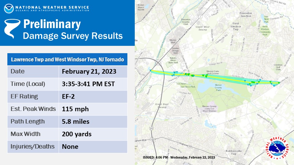
Public Information Statement - TornadoNOUS41 KPHI 222053 PNSPHI NJZ015-230900- Public Information Statement National Weather Service Mount Holly NJ 353 PM EST Wed Feb 22 2023 ...NWS Damage Survey for 02/21/23 Tornado Event ... Thunderstorms developing ahead of a cold front developed rotation over Mercer County. In addition to wind damage and hail reports, a tornado occurred in Mercer County. .Lawrence Township and West Windsor Township Tornado... Rating: EF-2 Estimated Peak Wind: 110-115 mph Path Length /statute/: 5.8 miles Path Width /maximum/: 200 yards Fatalities: 0 Injuries: 0 Start Date: February 21, 2023 Start Time: 3:35 PM EST Start Location: Lawrence Township, Mercer County, NJ Start Lat/Lon: 40.2785/-74.7028 End Date: February 21, 2023 End Time: 3:41 PM EST End Location: West Windsor Township, Mercer County, NJ End Lat/Lon: 40.2701/-74.5931 Sporadic minor tree damage was observed west of Interstate 295. A continuous path of tree damage was observed near Lawrence Station Road, particularly in a housing development along Fountayne Lane. Additional tree damage and damage to roofing occurred in a housing development at Lawrence Square. Estimated maximum wind speeds in this area were 105 to 115 mph. In a straight line from this damage, there was roofing damage at a residence and a commercial building as well as additional tree damage along Quaker Bridge Road. Tree damage continued at a park across the street and through the 2nd and 11th holes at the adjacent golf course. Additional sporadic tree damage occurred in residential areas east of the golf course in West Windsor Township. The last tree damage was observed near the intersection of Old Trenton Road and Village Road. The National Weather Service would like to extent our appreciation to New Jersey State Police, Mercer County Office of Emergency Management, and Lawrence Township Police Department for their help with the survey. && EF Scale: The Enhanced Fujita Scale classifies tornadoes into the following categories: EF0...Weak......65 to 85 mph EF1...Weak......86 to 110 mph EF2...Strong....111 to 135 mph EF3...Strong....136 to 165 mph EF4...Violent...166 to 200 mph EF5...Violent...>200 mph NOTE: The information in this statement is preliminary and subject to change pending final review of the event and publication in NWS Storm Data. $$ Brudy/Lee/Johnson |
 |


 Coastal Flood
 Marine Forecasts
 Text Products
 Climate Information
 Skywarn
 Submit Storm Report
 Weather Event Archives
 Forecast Discussion
 Emergency Managers
 Briefing Page