
Severe thunderstorms capable of damaging winds will be possible from the Ozark Plateau east into the Tennessee Valley Saturday. Rounds of heavy thunderstorms ahead of a slow moving front will continue locally heavy rainfall and scattered flash flooding potential from the Ozarks to the Ohio and Tennessee Valleys Saturday. Extreme heat will continue for the Intermountain West and Plains. Read More >
Mount Holly National Weather Service
Marine Zone Expansion to 60 NM Offshore
OVERVIEw
Beginning on or about April 16, 2026, National Weather Service (NWS) Weather Forecast Office (WFO) Philadelphia/Mount Holly, NJ (PHI) will assume forecast, watch, and warning responsibility for the coastal waters from Sandy Hook, NJ to Manasquan Inlet, NJ out to 20 to 40 Nautical Miles (NM) offshore, and from Manasquan Inlet, NJ to Fenwick Island, DE out to 20 to 60 NM offshore. Routine forecast services for these waters were previously the responsibility of the Ocean Prediction Center (OPC), with warning responsibility divided between WFO PHI and OPC. This change is part of a regional improvement that will result in all forecasts and warnings for coastal waterways within 60 NM of shore originating from the local WFO across the entire Contiguous United States (CONUS). There will be no change to the current forecast and warning services provided by WFO PHI for coastal waterways within 20 NM of shore.
JUSTIFICATION
The coastal waterways are lifelines of commerce in New Jersey and Delaware, frequented by commercial, recreational, and research vessels year-round. Major shipping lanes pass just off our coast, with commercial vessels from all over the world frequenting the nearby ports of Philadelphia and New York, among others. Additionally, fishermen often leave local ports bound for offshore fishing sites such as artificial reefs and the Gulf Stream. Recreational boating is also common, especially in the warm season. These activities primarily take place within 60 NM of shore, with mariners depending on reliable weather forecasts from the National Weather Service to ensure the safety of themselves and their crew, passengers, and cargo while on the water.
Marine Traffic Transit Counts (2017): Fishing Vessels

The above graphic shows that the majority of fishing activity is within 60 NM of shore, with vessels often traversing beyond the previous 20 NM offshore extent of forecasts from WFO PHI.
Marine Traffic Transit Counts (2017): Cargo and Tanker Ships

The Graphic above shows that most cargo and tanker vessels traverse about 20-60 NM offshore of New Jersey and Delaware. Note the shipping lanes extending into New York City and Philadelphia. Expanding WFO PHI forecast and warning responsibility to 60 NM offshore will cover significantly more commercial traffic.
With the redesignation of all forecast and warning responsibility for the coastal waters within 60 NM of the shore to WFO PHI, users will experience these benefits:
Improved forecast service continuity, with local WFO’s now responsible for issuing routine forecasts and warnings for all marine waters out to 60 NM offshore for the entire CONUS.
Increased number of forecast parameters with temperature, precipitation chances, and weather type among the parameters that are now available for mariners from 20 to 60 NM offshore out to 5 days in the future.
Improved forecast resolution, with point and click forecast capability now enabling mariners to get hourly forecasts for specific points (such as offshore artificial reefs) anywhere within 60 NM of shore out to 5 days in the future.
Expanded suite of short and long-fused watch/warning and advisory products to alert mariners to the potential for a variety of hazardous weather conditions.
WFO’s now have the capability to deliver Impact-based Decision Support Services (IDSS) to partners in support of incident response for incidents that occur anywhere within 60 NM of shore.
ZONE CHANGE DESCRIPTIONS

The above graphic shows the new alignment of marine forecast zones with light and dark blue zones now being the responsibility of WFO PHI.
| AREA | PREVIOUS ZONE NAME(S) | PREVIOUS ZONE NUMBER(S) | NEW ZONE NAME | NEW ZONE NUMBER |
| Ocean Waters from Sandy Hook, NJ to Manasquan Inlet, NJ out 20 to 40 NM |
Waters from Sandy Hook, NJ to Manasquan Inlet, NJ out 20 to 40 NM |
ANZ470
|
Waters from Sandy Hook NJ to Manasquan Inlet NJ from 20 to 40 NM (PHI) (Note: The area of this zone has not changed, but the zone number has) |
ANZ480 |
| Ocean Waters from Manasquan Inlet, NJ to Little Egg Inlet, NJ out 20 to 60 NM |
Waters from Manasquan Inlet, NJ to Little Egg Inlet, NJ out 20 to 40 NM (PHI)
Hudson Canyon to Baltimore Canyon out 60 to 120 NM offshore (Partial, OPC) |
ANZ471
ANZ821 |
Waters from Manasquan Inlet NJ to Little Egg Inlet NJ from 20 to 60 NM (PHI) | ANZ481 |
| Ocean Waters from Little Egg Inlet, NJ to Great Egg Inlet, NJ out 20 to 60 NM |
Waters from Little Egg Inlet, NJ to Great Egg Inlet, NJ out 20 to 40 NM (PHI)
Hudson Canyon to Baltimore Canyon out 60 to 120 NM offshore (Partial, OPC) |
ANZ472
ANZ821
|
Waters from Little Egg Inlet NJ to Great Egg Inlet NJ from 20 to 60 NM (PHI) | ANZ482 |
| Ocean Waters from Great Egg Inlet, NJ to Cape May, NJ out 20 to 60 NM |
Waters from Great Egg Inlet, NJ to Cape May, NJ out 20 to 40 NM (PHI) Hudson Canyon to Baltimore Canyon out 60 to 120 NM offshore (Partial, OPC)
|
ANZ473
ANZ821 |
Waters from Great Egg Inlet NJ to Cape May NJ from 20 to 60 NM (PHI) | ANZ483 |
| Ocean Waters from Cape May, NJ to Fenwick Island, DE out 20 to 60 NM |
Waters from Cape May, NJ to Fenwick Island, DE out 20 to 40 NM (PHI)
|
ANZ475
ANZ821
|
Waters from Cape May NJ to Fenwick Island DE from 20 to 60 NM (PHI) | ANZ485 |
FORECAST RESOURCES
| Product Name | WMO Header | AWIPS ID |
| Coastal Waters Forecast | FZUS51 | CWFPHI |
| Marine Weather Message | WHUS71 | MWWPHI |
| Special Marine Warning | WHUS51 | SMWPHI |
| Marine Weather Statement | FZUS71 | MWSPHI |
| Watch County Notification | WWUS61 | WCNPHI |
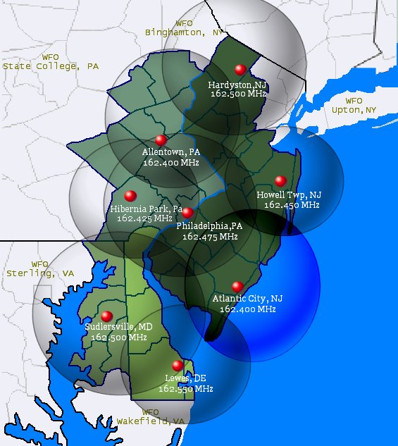
One of the most immediate and reliable ways to receive forecasts, watches, and warnings for the waterways of New Jersey and Delaware is through NOAA Weather Radio. The following table and map outline the best transmitter for area waterways:
| AREA | TRANSMMITTER LOCATION | TRANSMITTER FREQUENCY |
| Coastal Waters from Sandy Hook NJ to Manasquan Inlet NJ and their immediate tributaries. | Howell Twp, NJ (WXM-60) | 162.450 mhz |
| Coastal Waters from Manasquan Inlet NJ to Cape May NJ and their immediate tributaries. |
Atlantic City, NJ (KHB-38) |
162.400 mhz |
| Coastal Waters from Cape May NJ to Fenwick Island DE and Lower Delaware Bay. | Lewes, DE (WXJ-94) | 162.550 mhz |
Routine forecasts and warnings for mariners in New Jersey and Delaware waters can be found online at weather.gov/phi/marine.
Alternatively, to get the forecast for a specific point, visit weather.gov/marine/point and click on the map or enter you lat/lon.
Recorded area marine forecasts can be accessed by calling 609-261-6600 ext. 6 (coastal waters) or ext. 7 (offshore waters).
CONTACT
Please submit any questions or comments to:
WFO PHI Webmaster
National Weather Service
Philadelphia/Mount Holly
732 Woodlane Road
Mount Holly, NJ 08060
609-261-6600 x235
wfophi.webmaster@noaa.gov


 Coastal Flood
 Marine Forecasts
 Text Products
 Climate Information
 Skywarn
 Submit Storm Report
 Weather Event Archives
 Forecast Discussion
 Emergency Managers
 Briefing Page