
On this page you learn what types of flooding are typical in Texas and how do you protect yourself, your family and your home. You will also find out more about significant Texas floods. Finally, you'll find links to NWS offices that provide forecast and safety information for Texas, as well as links to our partners who play a significant role in keeping you safe.
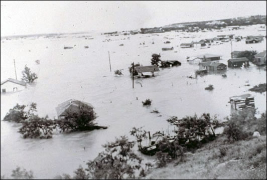
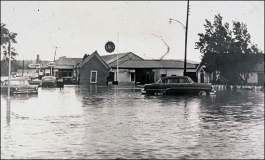
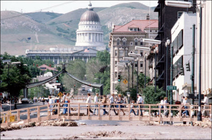
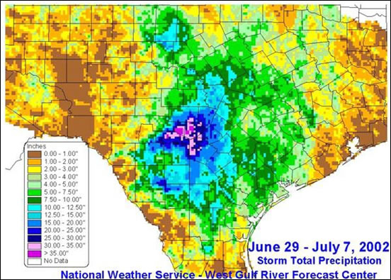
Just 4 years after a 500-year flood impacted parts of South Central Texas, another 500-year event impacted many of the same areas and even more of the state in 2002. June 30, 2002 was the beginning of an 8-day heavy rain event across a broad area of central and south central Texas. The heavy rain pattern developed when a low pressure system over the northern Gulf of America moved onshore into central Texas and became stationary as deep tropical Gulf moisture continued to feed into the area of instability for several days. The heavy rains initially developed from south Texas northward across San Antonio into the Hill Country on June 30 and July 1. On July 1, San Antonio International Airport reported 9.52 inches, which stands as the 1-day record for the month of July. By July 6, areas of flash flooding expanded as far north as Abilene, roughly 175 miles away from axis of heaviest rainfall. Several counties over the Hill Country and around San Antonio received between 25 and 35 inches of rain during the period. The highest 8-day total of 45.1 inches was reported at Waring in Kendall County.
Floodwaters were to blame for 12 fatalities, damage to about 48,000 homes, and total damages estimated at around $1 billion. There were 24 counties designated as federal disaster areas.
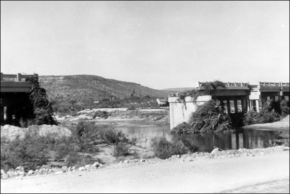
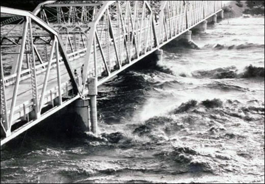
The flooding produced record flows along the Medina River, San Antonio River, Sabinal River, and Nueces River. High flows along the Guadalupe River produced the first ever flows over the emergency spillway at Canyon Lake since construction in 1968. Maximum flows of around 67,000 cubic feet per second over the Canyon Lake emergency spillway resulted in the creation of a downstream limestone gorge that was 1 mile long and up to 70 feet deep. Many of the residents that lost homes along the Guadalupe River in 1998 had rebuilt, only to see their homes carried downstream in 2002. Along the Medina River, Medina Lake also topped the emergency spillway, and the lake rose to within 18 inches of the top of the dam itself. Areas downstream from the dam were evacuated as a precaution because of the fear of dam failure.
|
|
|
|
|
|
Learn More:
A tropical storm formed in the Bay of Campeche during the morning of September 6, 1921, and reached hurricane intensity that afternoon. The hurricane made landfall during the early morning on September 7, 1921, near Vera Cruz Mexico. On the night of September 7, the storm had weakened to a tropical depression and crossed the Rio Grande at Rio Grande City. The remnant low traveled north and light rainfall began to fall in San Antonio on the evening of the 8. The Balcones Escarpment helped to produce orographic lift which enhanced the rainfall amounts over south central Texas.
During the evening of September 9, a deluge of rain was seen in San Antonio with rainfall totals of 18 inches observed in the northern part of San Antonio, causing a major flood on the San Antonio River and sending a 12-foot flood wave downstream. People caught in downtown were forced to scramble vertically to the upper floors of buildings to escape. Unfortunately, 51 people drowned as the flood wave peaked near 1:30 am. Water was 4 to 5 feet deep in the St. Mary's Church and Gunter hotel. As a result of this flood, the Olmos Dam was completed in 1928 as a flood-retention dam to protect downtown San Antonio.
This storm produced flooding from Temple to San Antonio. Another location heavily impacted was Travis and Williamson Counties. The city of Thrall in Williamson County experienced extreme rainfall during the evening of the 9th and into the early morning of the 10th. The U.S. Weather Bureau station in Thrall measured 23.4 inches in 6 hours, 31.8 inches in 12 hours, 36.4 inches in 18 hours, and 38.2 inches in 24 hours that ended at 7 am on September 10, 1921. The storm total rainfall was 39.7 inches which occurred over 36 hours. This total stands as the second greatest U.S. record for 24-hour rainfall. The storm claimed 87 lives near Taylor and another 93 in Williamson County. With 215 drownings, statewide this stands as the deadliest flood in Texas history. The remnant tropical cyclone caused $19 million (1921USD) in property losses.
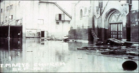
St. Mary's Church
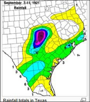
Texas Rainfall Map
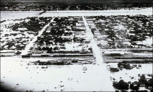
The flooding caused by the remnants of hurricane Alice was the worst ever experienced along the Rio Grande. This flood event was ranked as a one 2000 year event (0.0005 percent chance of occurrence in any given year). The Pecos River crested at 96.24 feet (29.25 meters) (948,000 cfs) at 1:30 am on June 28 near Comstock. The crest of 38.25 feet (11.63 meters) at Del Rio resulted in a flow of 1,140,000 cfs. Some of the worst damage was observed in Ozona where 15 people were killed and $2 million (1954 USD) in damage was reported. During a 24-hour period, 16.02 inches (407 mm) of rain was recorded. The storm total rainfall for this event was 24.07 inches (611 mm) reported 1 mile north of Pandale. The city of Eagle Pass Commercial Sector was flooded with over 8 feet (2.4 meters) of water. At Laredo, the Rio Grande has a peak crest of 61.35 feet (18.65 meters). This crest was at least 10 feet (3 meters) higher than the previous flood of record. Falcon Dam, about 285 miles to the south on the Rio Grande, had just been completed in October 1953.
During this severe drought, the reservoir was nearly empty going into the June 1954 flood. Within 3 days after the onset of the flood wave, flow was approaching conservation level. Hydrologist had predicted it would take 3 to 4 years to reach conservation level. The completed reservoir spared the Rio Grande Valley from major flooding. The Amistad Dam project had been in planning stages for decades before the storm and was finally started in 1960 as a result of this flood. Safe drinking water was restored to Laredo, Texas on July 12, 1954. Estimates for storm related deaths vary from 55 to 153.
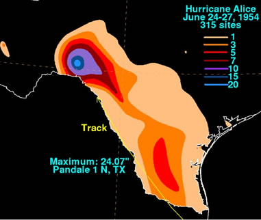
Hurricane Alice 1954–Rainfall and Track
Rio Grande at Eagle Pass June 29, 1954 - results of Hurricane Alice
Johnson Draw through Ozona
Johnson Draw through Ozona, 15 drownings, as a result of Hurricane Alice
Liveoak Creek at US Hwy 290 at Sheffield, bridge destroyed by flood of June 27–28 (During the night)
Devils River at Highway 90, results of Hurricane Alice
Learn More:

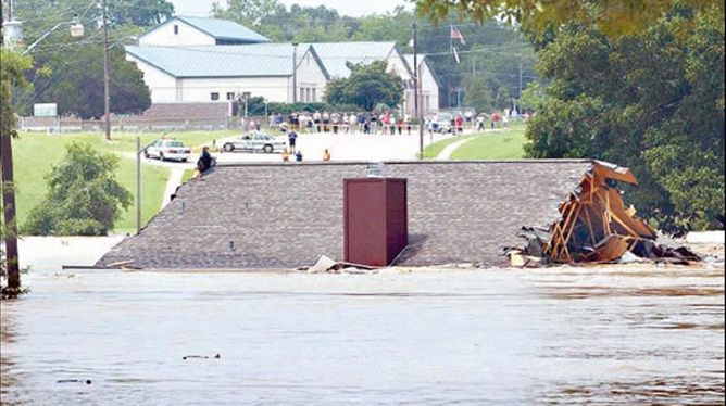
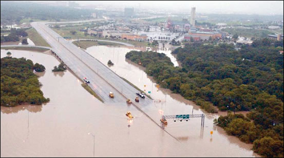
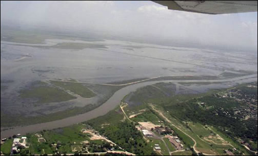
Tropical Storm Allison on June 5, 2001
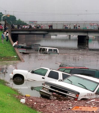
Trucks, cars and debris float on I-45 North near downtown Houston as onlookers gather on the Main street overpass after torrential rain from Tropical Storm Allison Saturday, June 9, 2001. AP Photo/Donna Carson
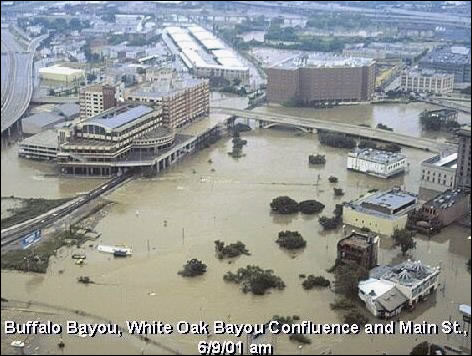
Buffalo Bayou, White Oak Bayou Confluence and Main St., June 9, 2001
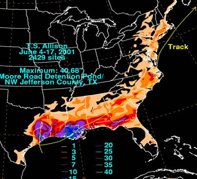
Tropical Storm Allison 2001–Rainfall and Track
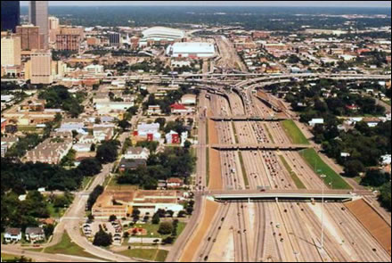
Highway Before Flood, Credit: Houston Chronicle / Dr. Neil Frank
Highway after flood looking like a major river instead of a major road. Credit: Houston Chronicle / Dr. Neil Frank
Learn More:
|
||||||

