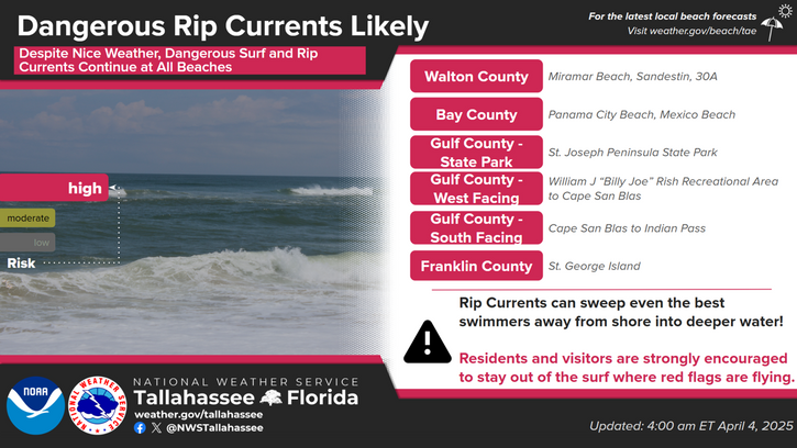
National Weather Service United States Department of Commerce

There is a Slight Risk for severe storms (level 2 of 5) for much of the area this afternoon and evening. Isolated strong to severe wind gusts of 40-60 mph and a few tornadoes are the primary hazards.
Timing of today's storms: - Southeast AL, southwest GA, and the FL Panhandle: most likely 12-4 PM CT (1-5 PM ET) - South central GA and the western FL Big Bend: most likely 3-7 PM CT (4-8 PM ET) - Valdosta metro and eastern Big Bend: most likely 7-11 PM ET
A Wind Advisory is in effect for much of south Georgia, all of southeast Alabama, and much of the FL Panhandle. Wind gusts of 35-45 mph are expected in the advisory area. Elsewhere, gusts of 25-35 mph will be common.
A Cold Weather Advisory is in effect of most areas west of the Flint and Apalachicola Rivers for Monday morning. Lows will be around 26-32 in these areas, but wind chills will drop to 17-25 during the morning commute. Dress warmly in multiple layers, check on those without adequate warmth, and practice fire safety.
Even more dangerous cold is expected Monday night into Tuesday morning with lows of 17-25 and wind chills of 9-15. An Extreme Cold Watch is in effect roughly from Albany to Tallahassee westward. A Cold Weather Advisory will likely be needed elsewhere in later updates.
A Hard Freeze is likely Monday night and Tuesday morning, and a Freeze Watch has been issued area wide for lows of 17-25.


Text Product Selector