A major winter storm is expected to bring heavy snow, strong winds, and coastal flooding across the Mid-Atlantic and Northeast that may cause impossible travel conditions and power outages. Blizzard conditions are possible along coastal areas from the DelMarVa Peninsula through southeastern New England. Wet weather and strong winds return to the Pacific Northwest and north-central California. Read More >
| Overview: | ||
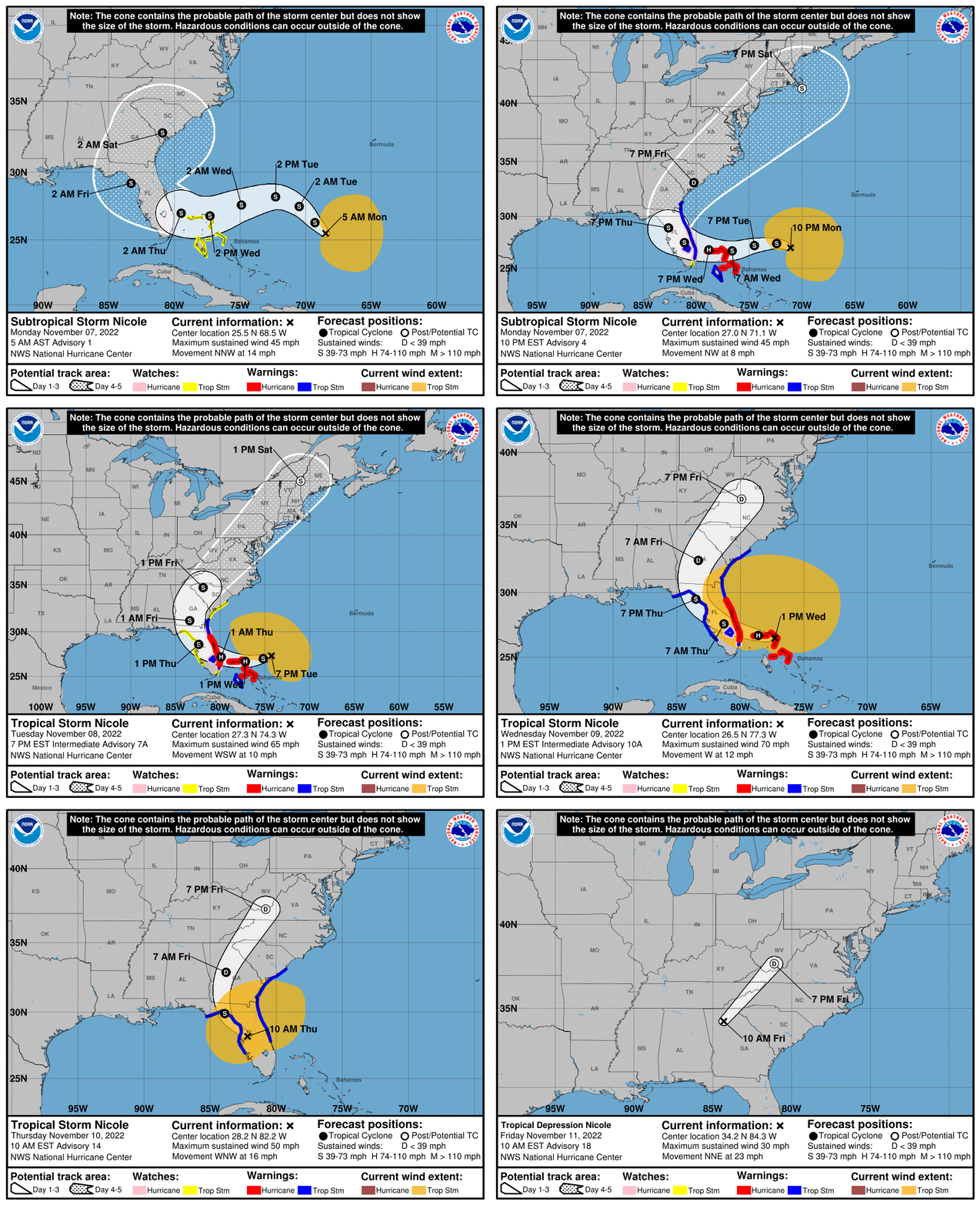
Hurricane Nicole first formed on November 7th as a sprawling low pressure system began to take on subtropical characteristics. As the system began to organize and the wind field contracted, Nicole became a Tropical Storm on Tuesday, November 8th. Nicole continued to intensify to a Category 1 Hurricane on November 9th after making landfall in the northern Bahamas. The storm would go on to make landfall along the Florida east coast near Vero Beach during the early morning hours of November 10th. Substantial impacts were felt along the east coast of the state as hurricane-force winds, heavy rainfall, and high surf battered the region of the coastline still reeling from Hurricane Ian. Some of this heavy rainfall and stronger wind also impacted West Central and Southwest Florida. |
||
| Most images on this page can be magnified by clicking, and resized back to original size with a second click. |
||
|
Infrared Satellite
|
Radar Loop
|
|
Nicole History: |
||
Nicole was the sixteenth and final storm of the 2022 Hurricane Season. Becoming a late season hurricane, Nicole briefly reached Category 1 strength (on the Saffir-Simpson Hurricane Wind Scale), before making landfall along the Florida East Coast near Vero Beach, Florida. Nicole was only the 3rd hurricane on record to make landfall in Florida during the month of November, with the last storm being Hurricane Kate in 1985. Prior to reaching the United States, Nicole also impacted the northern Bahamas. Impacting areas still recovering from Major Hurricane Ian and contributing to major beach erosion along the East Coast, Nicole caused over $1 billion in damage along its track and was responsible for 5 direct fatalities. The origins of Nicole can be traced back to a broad non-tropical area of low pressure that developed in the Western Atlantic to the north of the Greater Antilles. The large, disorganized system lacked a closed center of circulation, but did produce disorganized areas of showers and thunderstorms, along with winds up to Gale Force. By 5AM on November 7th, 2022, the low had become organized enough to be considered a Subtropical Storm, and thus took on the name Nicole. However, the storm lacked a closed center of circulation and still had an expansive wind field. It would take another 30 hours for Nicole to consolidate further and develop a closed center of circulation to become a tropical storm. At 11:55AM on November 9th, Nicole made landfall on Great Abaco Island in the northern Bahamas. A few hours later, the storm would go on to make landfall again on Grand Bahama Island. Despite making multiple landfalls with islands in the northern Bahamas, Nicole would continue to strengthen. The storm was largely unaffected by the islands given the large size and warm ocean waters. While still over Grand Bahama Island, Nicole strengthened into a Category 1 Hurricane. At 3:00AM on November 10th, Hurricane Nicole made landfall as a Category 1 Hurricane near Vero Beach, Florida on Hutchinson Island. Strong swells in combination with astronomical high tide caused devastating storm surge and coastal flooding along the east central Florida coast. Periods of heavy rainfall across the Saint Johns River basin further aggravated flooding concerns, causing another period of moderate to major flooding at several points along the river just as water levels had receded after Major Hurricane Ian. The storm would continue to track westward bringing high winds and heavy rainfall to portions of West Central and Southwest Florida before turning Northwest and eventually weakening into a Tropical Depression over southern Georgia. The complete analysis of the storm can be found in the National Hurricane Center Tropical Cyclone Report on Hurricane Nicole. |
||

|

|
Rainfall: |
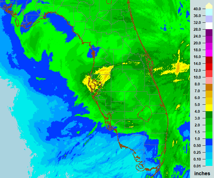
When compared to Major Hurricane Ian, Hurricane Nicole brought significantly lower rainfall totals to West Central and Southwest Florida. However, a swath of 4 to 6 inches did fall across portions of the immediate Tampa Bay Area, with localized totals that were even higher. The heaviest rain fell across the area during the morning hours on November 10th. As the storm approached the Gulf of America, the added energy from daytime heating and relatively warm Gulf Waters provided a boost to ongoing storms on the southern side of the center. These storms “trained†(or repeatedly moved) over the greater Tampa Bay area.. The image below shows the total radar-estimated rainfall for the event. Areas with yellow and orange colors experienced the highest amount of rainfall for the event. This swath covers a large portion of the Tampa Bay Area. |

|
STORM TOTAL RAINFALL FROM 0000 UTC NOV 11 UNTIL 0000 UTC NOV 11 --------------------------------------------------------------------- CITY/TOWN COUNTY ID RAINFALL LAT LON (IN) DEG DECIMAL --------------------------------------------------------------------- DADE CITY 1.8 WSW PASCO FL-PS-10 6.11 28.35 -82.22 DADE CITY 5.1 W PASCO FL-PS-81 5.49 28.35 -82.28 LACOOCHEE 1.0 NE PASCO FL-PS-49 5.21 28.48 -82.16 DAVENPORT POLK AS292 5.13 28.25 -81.65 ST. PETERSBURG 6.2 WNW PINELLAS FL-PN-120 5.13 27.79 -82.74 THONOTOSASSA 3.6 NE HILLSBOROUGH FL-HB-123 5.12 28.09 -82.26 LARGO 3.1 SE PINELLAS FL-PN-94 4.70 27.88 -82.74 THONOTOSASSA 2.3 ESE HILLSBOROUGH FL-HB-180 4.69 28.05 -82.27 ZEPHYRHILLS 2.6 NNW PASCO FL-PS-7 4.63 28.27 -82.19 PALMETTO 6.4 ENE MANATEE FL-MA-22 4.60 27.56 -82.48 PLANT CITY 6.4 NW HILLSBOROUGH FL-HB-1 4.37 28.07 -82.21 GULFPORT 0.6 SSE PINELLAS FL-PN-87 4.33 27.74 -82.71 SEMINOLE 3.3 WNW PINELLAS FL-PN-77 4.27 27.86 -82.83 ST. PETERSBURG 3.9 NNE PINELLAS FL-PN-108 4.09 27.81 -82.63 SAN ANTONIO PASCO GW2574 4.03 28.32 -82.30 CLEARWATER 2.6 NE PINELLAS FL-PN-121 4.00 28.01 -82.74 LARGO 1.5 SSW PINELLAS FL-PN-104 3.92 27.89 -82.79 NEW PORT RICHEY 2.3 SW PASCO FL-PS-68 3.89 28.22 -82.74 ST. PETERSBURG 3.2 NNW PINELLAS FL-PN-34 3.86 27.80 -82.65 NORTH PORT 5.2 NNE SARASOTA FL-SS-84 3.86 27.12 -82.16 LAND O LAKES 1.5 SSE PASCO FL-PS-43 3.82 28.20 -82.44 PALM HARBOR 1.0 S PINELLAS FL-PN-71 3.79 28.07 -82.77 AUBURNDALE POLK FW9119 3.78 28.13 -81.79 ST. PETERSBURG 2.2 N PINELLAS FL-PN-79 3.74 27.79 -82.64 SUN CITY CENTER 0.9 S HILLSBOROUGH FL-HB-139 3.68 27.71 -82.35 LOUGHMAN 2.0 ESE POLK FL-PK-78 3.68 28.22 -81.54 GREATER NORTHDALE 0.4 EN HILLSBOROUGH FL-HB-48 3.67 28.11 -82.51 ST. PETERSBURG 2.5 S PINELLAS FL-PN-81 3.62 27.72 -82.65 BRANDON 2.8 SW HILLSBOROUGH FL-HB-136 3.59 27.90 -82.33 ST. PETERSBURG 1.6 WNW PINELLAS FL-PN-74 3.58 27.77 -82.67 TAMPA 5.0 NNE HILLSBOROUGH FL-HB-55 3.56 28.01 -82.42 LAKE SARASOTA 7.9 ESE SARASOTA FL-SS-81 3.56 27.26 -82.31 POLK CITY 1.6 WSW POLK FL-PK-55 3.55 28.17 -81.85 VALRICO 1.6 NNW HILLSBOROUGH FL-HB-160 3.50 27.97 -82.25 CARROLLWOOD VILLAGE 2.3 HILLSBOROUGH FL-HB-168 3.50 28.07 -82.56 LAND O' LAKES 1.8 SE PASCO FL-PS-78 3.50 28.20 -82.44 ELFERS 6.3 ESE PASCO FL-PS-65 3.45 28.19 -82.62 LUTZ 0.6 WSW HILLSBOROUGH FL-HB-116 3.44 28.13 -82.47 ST. PETERSBURG 4.9 WNW PINELLAS FL-PN-99 3.40 27.78 -82.72 3 W RUSKIN HILLSBOROUGH FL-HB-178 3.37 27.71 -82.48 DUNEDIN 2.8 ESE PINELLAS FL-PN-36 3.35 28.03 -82.76 DAVENPORT POLK EW1114 3.33 28.18 -81.62 DAVENPORT 1.9 NW POLK FL-PK-67 3.25 28.18 -81.62 LAKELAND 2.8 SSW POLK FL-PK-90 3.25 28.00 -81.97 PANTHER PORTABLE NO. 1 POLK TS738 3.25 28.02 -81.48 RUSKIN 3.9 ENE HILLSBOROUGH FL-HB-181 3.19 27.74 -82.37 CLEARWATER PINELLAS EW9739 3.16 28.01 -82.71 LUTZ 1.3 SSE HILLSBOROUGH FL-HB-27 3.11 28.12 -82.45 INVERNESS 1.3 SSE CITRUS FL-CT-43 3.10 28.82 -82.33 VALRICO 2.8 SSE HILLSBOROUGH FL-HB-60 3.09 27.91 -82.24 NORTH PORT 4.7 NNE SARASOTA FL-SS-15 3.09 27.11 -82.17 CARROLLWOOD 0.7 NNE HILLSBOROUGH FL-HB-156 3.08 28.06 -82.49 PLANT CITY 1.9 SW HILLSBOROUGH FL-HB-169 3.05 27.98 -82.15 0.7 E HARBOR BLUFFS PINELLAS MKYF1 2.99 27.91 -82.82 LAKE WALES HIGHLANDS LWEF1 2.98 27.44 -81.39 UNIVERSITY WEST 2.0 WNW HILLSBOROUGH FL-HB-40 2.97 28.08 -82.46 CLEARWATER 1.6 N PINELLAS FL-PN-83 2.96 28.00 -82.76 OXFORD 0.8 SW SUMTER FL-ST-35 2.96 28.92 -82.05 3 NNE LAKE JOSEPHINE HIGHLANDS SBRHC 2.96 27.44 -81.42 2.8 NE SEFFNER HILLSBOROUGH MCNF1 2.94 28.03 -82.25 RIVERVIEW 2.1 NNW HILLSBOROUGH FL-HB-150 2.91 27.90 -82.32 LAKELAND 5.3 WNW POLK FL-PK-32 2.91 28.07 -82.04 2.4 E CLEARWATER PINELLAS PIAF1 2.91 27.97 -82.73 BRANDON 2.8 N HILLSBOROUGH FL-HB-162 2.87 27.97 -82.30 LAKE PLACID 9.4 SE HIGHLANDS FL-HL-1 2.87 27.21 -81.26 RIVERVIEW 4.8 SSW HILLSBOROUGH FL-HB-98 2.76 27.80 -82.34 2 S POLK CITY POLK ABRNL 2.75 28.14 -81.82 BRADENTON 11.0 E MANATEE FL-MA-18 2.75 27.50 -82.40 AUBURNDALE POLK AV598 2.72 28.04 -81.78 0.5 NE TARPON SPRINGS PINELLAS TRPF1 2.72 28.15 -82.75 SEBRING 7.9 ESE HIGHLANDS FL-HL-43 2.70 27.44 -81.34 SPRING HILL 2.4 NW HERNANDO FL-HN-14 2.69 28.50 -82.60 PORT CHARLOTTE 3.7 NE CHARLOTTE FL-CH-37 2.68 27.02 -82.07 2.5 W OLDSMAR (RR) PINELLAS TBFF1 2.67 28.05 -82.71 SEBRING HIGHLANDS EW0408 2.66 27.50 -81.48 DAVENPORT POLK DW5167 2.64 28.26 -81.64 LAKE SARASOTA 0.5 NE SARASOTA FL-SS-69 2.63 27.30 -82.43 2.6 SW SAFETY HARBOR PINELLAS KAPF1 2.63 27.98 -82.71 1.1 NW LACOOCHEE (RR) HERNANDO TRBF1 2.63 28.48 -82.18 2.8 NE SEFFNER (R2) HILLSBOROUGH MCNF1 2.62 28.03 -82.25 SPRING HILL 2.1 W HERNANDO FL-HN-35 2.61 28.48 -82.60 SEBRING 2.7 SE HIGHLANDS FL-HL-38 2.61 27.47 -81.42 FROSTPROOF 4.6 SW POLK FL-PK-35 2.60 27.70 -81.59 INVERNESS 4.4 NW CITRUS FL-CT-31 2.59 28.88 -82.40 LUTZ 2.2 SSE HILLSBOROUGH FL-HB-51 2.59 28.11 -82.45 4.0 NE NORTH BROOKSVILLE HERNANDO BROF1 2.57 28.62 -82.37 CHIEFLAND 1.4 NNW LEVY FL-LV-17 2.57 29.50 -82.87 15.2 S LAKE MARIAN POLK KSAF1 2.57 27.66 -81.13 THE MEADOWS 6.2 NE MANATEE FL-MA-32 2.56 27.43 -82.40 WILLISTON 6.9 NW LEVY FL-LV-14 2.56 29.44 -82.54 3.9 SE NEW PORT RICHEY PASCO ELFF1 2.53 28.21 -82.67 LUTZ 2.0 E HILLSBOROUGH FL-HB-37 2.50 28.14 -82.43 AVON PARK AF RANGE 1 HIGHLANDS APRF1 2.49 27.60 -81.21 FORT MYERS 10.0 NE LEE FL-LE-76 2.49 26.72 -81.72 WINTER HAVEN POLK AP566 2.48 28.06 -81.77 SPRING HILL 3.6 ESE HERNANDO FL-HN-41 2.48 28.46 -82.51 NORTH FORT MYERS LEE GW1681 2.48 26.75 -81.93 DUNEDIN 2.9 ESE PINELLAS FL-PN-91 2.47 28.03 -82.76 5.4 NE ZEPHYRHILLS PASCO WRCF1 2.46 28.27 -82.10 PUNTA GORDA 1.4 NNW CHARLOTTE FL-CH-19 2.44 26.92 -82.07 WIMAUMA HILLSBOROUGH GW0185 2.40 27.72 -82.33 NORTH PORT 1.6 ENE SARASOTA FL-SS-14 2.39 27.06 -82.17 TAMPA HILLSBOROUGH KTPA 2.38 27.97 -82.53 2.0 E DUNEDIN PINELLAS CCKF1 2.38 28.02 -82.74 RIVERVIEW 0.9 ENE HILLSBOROUGH FL-HB-114 2.38 27.87 -82.30 LAKE WALES POLK FW4209 2.37 27.90 -81.39 WEEKI WACHEE 1.7 NNE HERNANDO FL-HN-40 2.36 28.54 -82.57 BRADENTON 4.9 WNW MANATEE FL-MA-17 2.36 27.52 -82.65 SPRING HILL 3.3 SE HERNANDO FL-HN-7 2.32 28.45 -82.52 DESOTO LAKES 4.2 NNE MANATEE FL-MA-43 2.31 27.43 -82.46 AVON PARK AFR NORTH POLK TT601 2.31 27.69 -81.33 3.0 NW OLDSMAR PINELLAS BOLF1 2.30 28.09 -82.69 NORTH PORT 2.6 E SARASOTA FL-SS-34 2.30 27.05 -82.15 LEHIGH ACRES LEE GW0469 2.28 26.59 -81.61 MACDILL AFB TAMP HILLSBOROUGH KMCF 2.26 27.85 -82.52 1.9 N THONOTOSASSA HILLSBOROUGH MORF1 2.26 28.10 -82.31 VAMO 2.1 E SARASOTA FL-SS-62 2.24 27.23 -82.46 HERNANDO 4.4 WSW CITRUS FL-CT-30 2.22 28.87 -82.44 WEEKI WACHEE 7.1 NNE HERNANDO FL-HN-24 2.21 28.61 -82.54 2.9 NW LITHIA HILLSBOROUGH LITF1 2.20 27.87 -82.21 LAKE SUZY 1.0 W DESOTO FL-DS-3 2.18 27.04 -82.05 1.9 N THONOTOSASSA (R2) HILLSBOROUGH MORF1 2.17 28.10 -82.31 FROSTPROOF POLK AR664 2.16 27.76 -81.57 ZEPHYRHILLS MUNICIPAL AI PASCO KZPH 2.14 28.23 -82.15 DUNEDIN PINELLAS FW1830 2.13 28.01 -82.78 MULBERRY 1.1 NNW POLK FL-PK-73 2.11 27.92 -81.98 NOKOMIS 3.6 E SARASOTA FL-SS-65 2.11 27.13 -82.38 FEATHER SOUND 1.3 S PINELLAS FL-PN-105 2.10 27.89 -82.66 HUDSON 1.1 ESE PASCO FL-PS-1 2.10 28.35 -82.68 2.7 NW RIVERVIEW HILLSBOROUGH NACF1 2.10 27.90 -82.35 SARASOTA 5.9 NE MANATEE FL-MA-41 2.09 27.40 -82.49 BARTOW POLK AP769 2.09 27.88 -81.82 RIVERVIEW 2.1 WNW HILLSBOROUGH FL-HB-166 2.09 27.89 -82.35 2 N LAKE JOSEPHINE HIGHLANDS SBRNG 2.09 27.43 -81.44 HOMOSASSA 6.0 SE CITRUS FL-CT-29 2.08 28.73 -82.54 2.2 NW PINELLAS PARK PINELLAS PNBF1 2.08 27.87 -82.74 1 NE SEMINOLE PINELLAS SMNSC 2.08 27.86 -82.77 7.3 NW BUCKHEAD RIDGE HIGHLANDS SKRF1 2.07 27.22 -80.97 RUSKIN 1.8 ESE HILLSBOROUGH FL-HB-44 2.06 27.71 -82.40 6.8 S ZEPHYRHILLS HILLSBOROUGH KNTF1 2.05 28.14 -82.15 PORT CHARLOTTE 3.3 E CHARLOTTE FL-CH-15 2.03 26.98 -82.06 6.5 NW BRIGHTON HIGHLANDS IDRF1 2.03 27.27 -81.18 WINTER HAVEN POLK KGIF 2.02 28.07 -81.75 5.5 SE CHIEFLAND LEVY CHIF1 2.00 29.41 -82.82
Winds: |
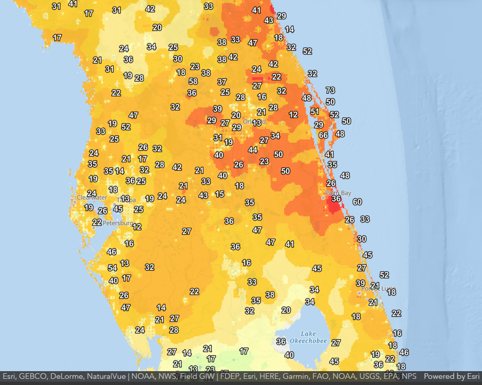
There were also some strong wind gusts associated with Nicole. Observed peak winds across West Central and Southwest Florida reached Tropical Storm Force in some locations. |

|