| Overview of Changes
|
|
Starting July 15, 2025, the National Weather Service will begin reporting all observations in the Withlacoochee River Basin in the NAVD88 datum. This change is being done to standardize water level reporting throughout the basin and improve tracking of flooding during high impact events. Additionally, 18 river observation sites will be added to the NWS water webpage, improving monitoring capability throughout the Withlacoochee Basin.
This webpage will explore why these changes are being made, and what this means for users of the data along the river. |
| Smaller graphics within this page can be magnified (enlarged) by left clicking on them and resized back to original size with a second click. |
| Why Are Changes Being Made?
|
|||
|
Recent events highlighted the need to make adjustments to how water level information is provided to the public and partners. |
|||
Challenges Identified During Hurricane Milton |
|||
|
Hurricane Milton caused significant river flooding in the Withlacoochee River Basin. Existing gauges captured this flooding. However, a lack of gauge datum standardization meant that the extent of flooding was difficult to track, and made it confusing for many users of this data to understand how that flooding would impact locations downstream.
An example of this confusion was seen when looking at the predicted flooding on the Withlacoochee River near Holder at SR200 compared to Dunnellon. These two sites are only a short distance apart, but the crest height at Dunnellon was nearly twenty feet higher than at Holder, implying a worse impact at face value. However, the hydrographs below show that the actual flooding at Dunnellon only reached Minor Flood stage, which means the actual extent of flooding impacts was much lower. Meanwhile, Holder briefly reached Major Flood stage which caused significant impacts in the vicinity. |
|||
|
|||
This can also be seen in the Flood Indundation maps at these two locations following Hurricane Milton. |
|||
|
|||
From a user perspective (and even for actual meteorologists), this discrepancy became a point of confusion when trying to message impacts, particularly in conveying the actual timing for when the most impactful crests would occur. To help alleviate some of this confusion, Meteorologists and Hydrologists with the National Weather Service created timing graphics to help depict the actual timing for the worst impacts at each major point along the river. |
|||
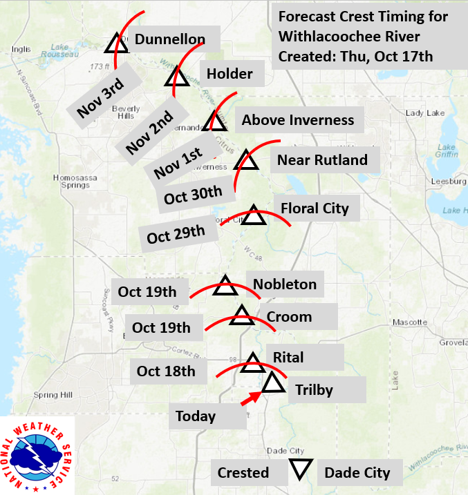 Forecast crest timing at different points along the Withlacoochee River |
| The Different Datums in Use
|
|
Across Florida river basins, there are two datums currently in use: the river stage height (water level above a fixed reference point), and water surface elevation above the North American Vertical Datum of 1988 (NAVD88). |
| Stage Height
|
|
The graphic below provides a depiction of how stage height is determined. Rather than measuring the depth of the water from the river's bottom (which changes over time), stage height is measured from a fixed river reference point that will not change over time. That point is known as the gauge zero point (and represents a water level of zero feet). The goal is to provide a consistent forecast that users can lean on to understand how water levels change and impact them at the gauge location. |
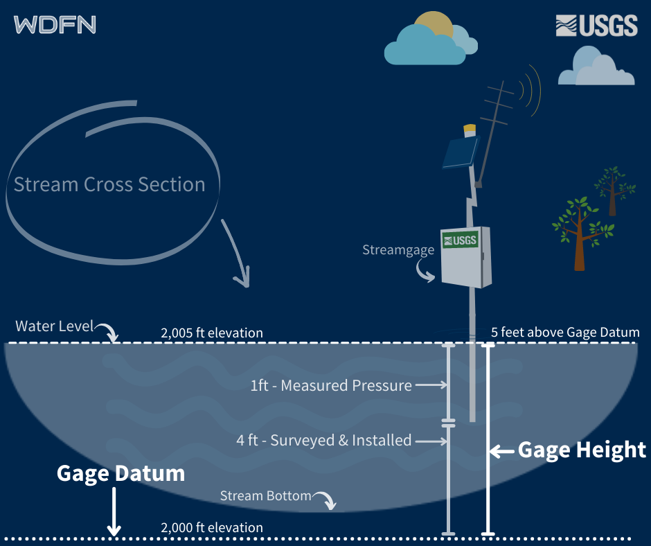 Gage height and gage datum graphic. Gage height is the measurement from the water surface down to the gage datum. |
In practice, however, this leads to inconsistent values along a river basin. A deeper section of river will have a higher water, and a more shallow section will have a lower water level. Thus, it can be challenging to track how water is flowing downstream during high-impact flood events. |
Water Surface Elevation Above Datum (NAVD88) |
|
The North American Vertical Datum of 1988 (NAVD88), provides a reference to the height of the water surface elevation in this particular datum. This datum is used to determine a location's elevation. Since the gauge zero point is already at a known elevation above NAVD88, that elevation becomes the new gauge zero point. The image below depicts the change for the Withlacoochee River at Trilby. |
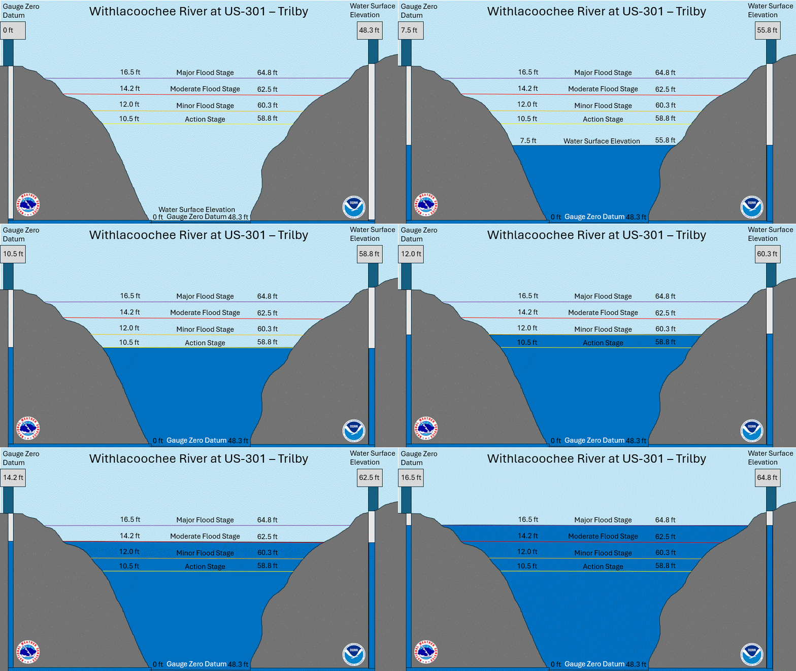 Water level changes for the Withlacoochee River at US 301 Trilby. |
| Proposed Water Level Changes
|
|
Forecasts are issued for five locations in the Withlacoochee River Basin during times of high water. River flood warnings are issued for these locations whenever the river rises above minor flood stage. Below is map depicting the location of these forecast points, as well as the overall boundaries of the river basin, courtesy of the Florida Department of Environmental Protection (FLDEP) and the Southwest Florida Water Management District (SWFWMD). |
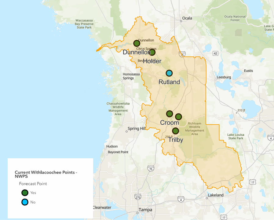 Current Withlacoochee River Basin Forecast Points |
As part of changing the reporting level, the numerical value of the river observation and the associated flood stages will change. However, the impacts associated with each flood category are unchanged as flood stages are converted to the new system (NAVD88 equivalent) and rounded to the nearest tenth. |
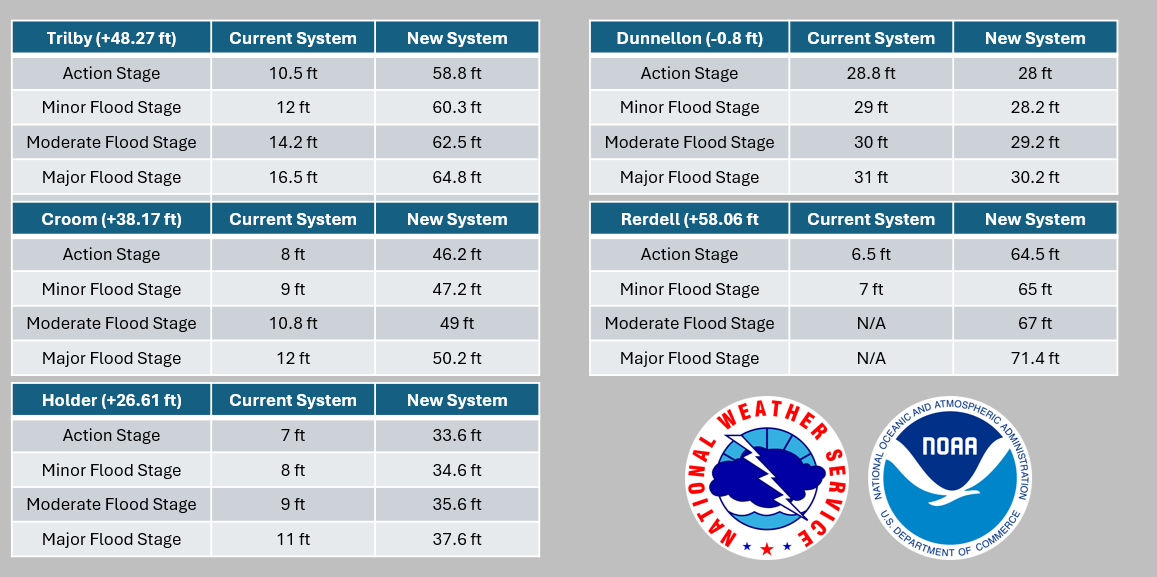 Current Stage Levels and New Levels |
| Key Facts: |
|
| New River Gauges
|
|
As part of updating the datum to NAVD88 at the river forecast points on the Withlacoochee River, there will be an additional 18 river gauges added to our river page to monitor water conditions throughout the basin. The map below depicts all river gauges currently (circles) and proposed (triangles) on the Withlacoochee River. |
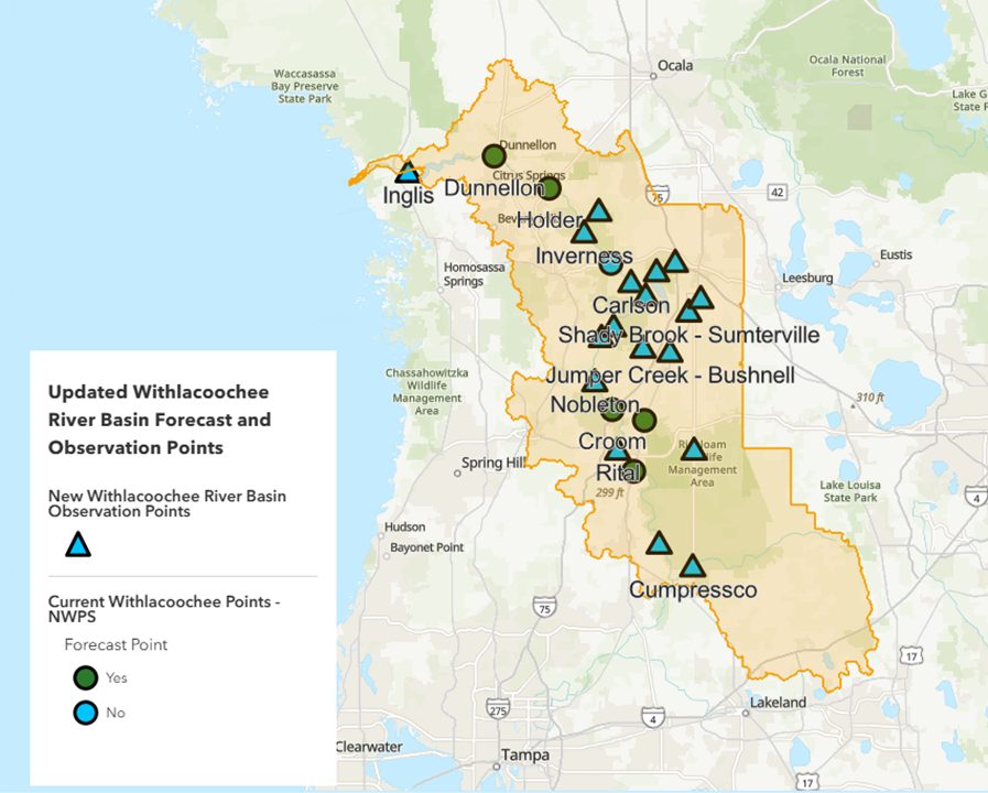 New Withlacoochee River Basin Forecast Points |
| Key Facts: |
|
| Improved Forecast Services
|
|
These changes are being made in consultation with the Southwest Florida Water Management District as well as Pasco, Hernando, Sumter, Citrus, and Levy Counties, and in partnership with the U.S. Geologic Survey.
Ultimately, the goal of this project is to have data in a format that allows for easier and more consistent decision-making. By standardizing the data, flood tracking will be easier, and individual users will be able to compare their local elevation to the current water level to assess impacts on a more granular level. |
| Contact/Feedback
|
This change request is being solicited via the National Service Change Notice (SCN) process. Questions, comments, and/or concerns on this initiative can be directed to:
|