Atlantic Storm Names
|
| 2017
|
2018
|
2019
|
2020
|
2021
|
2022
|
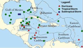
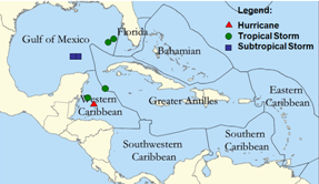
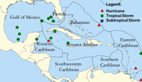
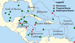
Formation Points for Tropical Cyclones
Affecting the West Coast of Florida
(1901-2007)
|
 |
 |
| May through November |
May through July |
|
 |
 |
| July through September |
September through November |
Brief Background |
|
Hurricanes are products of an interaction between both the ocean and the atmosphere. Fueled by energy from the warm ocean waters, they can be steered by the easterly trade winds, as well as the temperate westerlies. Some hurricanes, especially strong ones, are even able to alter the environment that steers them. This is a major reason why it can sometimes be very difficult to predict where a particular hurricane will track.
Tracking Hurricanes
The National Hurricane Center (NHC), in Miami FL is responsible for tracking and forecasting movement for all tropical storms and hurricanes across the Atlantic, Caribbean, Gulf of America and the eastern Pacific. The forecasters at the NHC use many different tools to help them make the best forecast possible. Some of those tools include: Satellite imagery, Ship/bouy observations, aircraft reconnaissance, and computer track models. Aircraft reconnaissance is typically performed by the 53rd Weather Reconnaissance Squadron of the Air Force Reserve, known as the "Hurricane Hunters". The mission of the Hurricane Hunters is to fly into tropical storms/hurricanes to gather real-time data about the pressure and wind fields of the storm. This crucial data can then be input into the computer track models, helping the hurricane forecasters at the NHC to make the best possible track prediction of the storm.
Official Hurricane Season
The official Atlantic Basin (including the Caribbean and Gulf of America) Hurricane Season runs from June 1 through November 30. These dates were chosen from climatological records, which show that the majority of tropical storms and hurricanes occur during this six month period, with a peak in activity from about mid August to mid October. However, tropical systems have been known to develop outside of this time frame, but it is relatively rare.
Each year on average, the Atlantic, Caribbean and Gulf of America will see about 10 named storms (including hurricanes and tropical storms), six of which will be hurricanes. Usually, most hurricanes remain out over the open ocean, causing problems mainly to shipping. However, about five hurricanes strike somewhere along the United States coastline every three years. Of these five, two will be major hurricanes (Category 3 or higher on the Saffir-Simpson Scale).
|
| Tropical Definitions |
- Tropical Cyclone: A generic term for a non-frontal synoptic scale cyclone originating over tropical or subtropical waters with organized convection and a definite cyclonic (counter-clockwise) surface wind circulation.
- Tropical Depression: A tropical cyclone in which the maximum one-minute sustained surface wind is 38 mph (33 kts) or less.
- Tropical Storm: A tropical cyclone in which the maximum one-minute sustained surface wind ranges from 39 to 73 mph (34 to 63 kts) inclusive.
- Hurricane/Typhoon: A tropical cyclone in which the maximum one-minute sustained surface wind is 74 mph (64 kts) or greater. "Typhoon" is the term used for hurricane-strength tropical cyclones in the western Pacific Ocean.
- Storm Surge: An abnormal rise in sea level accompanying a tropical cyclone or other intense storm. The height of the surge is computed by subtracting the "normal" astronomical tide from the observed level of the sea (storm tide).
- Storm Tide: The actual level of the sea which results from the astronomical tide combined with the storm surge.
(Storm Tide = Storm Surge + Astronomical Tide)
Watches/Warnings (Issued by: National Hurricane Center)
- Hurricane Warning: An announcement that hurricane conditions (sustained winds of 74 mph or higher) are expected somewhere within the specified coastal area. Because hurricane preparedness activities become difficult once winds reach tropical storm force, the hurricane warning is issued 36 hours in advance of the anticipated onset of tropical-storm-force winds.
- Hurricane Watch: An announcement that hurricane conditions (sustained winds of 74 mph or higher) are possible within the specified coastal area. Because hurricane preparedness activities become difficult once winds reach tropical storm force, the hurricane watch is issued 48 hours in advance of the anticipated onset of tropical-storm-force winds.
- Tropical Storm Warning: An announcement that tropical storm conditions (sustained winds of 39 to 73 mph) are expected somewhere within the specified coastal area within 36 hours.
- Tropical Storm Watch: An announcement that tropical storm conditions (sustained winds of 39 to 73 mph) are possible within the specified coastal area within 48 hours.
Hurricane Local Statement (Issued Locally)
- Hurricane Local Statement (HLS): Issued to the public by local NWS offices to provide more specific information about how a tropical storm or hurricane will affect a particular NWS office's county warning area (CWA). Examples of some information may be: Onset time of tropical storm/hurricane force winds, amount of rainfall expected, storm surge values, evacuation orders/road closures/shelters, and any other information that would help to reduce the loss of life and property. A new HLS is released to the public approximately one hour after each hurricane/tropical storm advisory is sent by the National Hurricane Center in Miami, FL.
|
| Hurricane Classifications |
|
Hurricanes are rated using the Saffir Simpson Scale. This scale ranges from category 1 (weakest) to category 5 (strongest). This classification scheme can be used to give an estimate of the potential property damage and flooding expected along the coast from a hurricane.
- Category One Hurricane (Sustained winds 74-95 mph [119-153 km/hr])
Very dangerous winds will produce some damage
People, livestock, and pets struck by flying or falling debris could be injured or killed. Older (mainly pre-1994 construction) mobile homes could be destroyed, especially if they are not anchored properly as they tend to shift or roll off their foundations. Newer mobile homes that are anchored properly can sustain damage involving the removal of shingle or metal roof coverings, and loss of vinyl siding, as well as damage to carports, sunrooms, or lanais. Some poorly constructed frame homes can experience major damage, involving loss of the roof covering and damage to gable ends as well as the removal of porch coverings and awnings. Unprotected windows may break if struck by flying debris. Masonry chimneys can be toppled. Well-constructed frame homes could have damage to roof shingles, vinyl siding, soffit panels, and gutters. Failure of aluminum, screened-in, swimming pool enclosures can occur. Some apartment building and shopping center roof coverings could be partially removed. Industrial buildings can lose roofing and siding especially from windward corners, rakes, and eaves. Failures to overhead doors and unprotected windows will be common. Windows in high-rise buildings can be broken by flying debris. Falling and broken glass will pose a significant danger even after the storm. There will be occasional damage to commercial signage, fences, and canopies. Large branches of trees will snap and shallow rooted trees can be toppled. Extensive damage to power lines and poles will likely result in power outages that could last a few to several days. Hurricane Dolly (2008) is an example of a hurricane that brought Category 1 winds and impacts to South Padre Island, Texas.
- Category Two Hurricane (Sustained winds 96-110 mph [154-177 km/hr])
Extremely dangerous winds will cause extensive damage
There is a substantial risk of injury or death to people, livestock, and pets due to flying and falling debris. Older (mainly pre-1994 construction) mobile homes have a very high chance of being destroyed and the flying debris generated can shred nearby mobile homes. Newer mobile homes can also be destroyed. Poorly constructed frame homes have a high chance of having their roof structures removed especially if they are not anchored properly. Unprotected windows will have a high probability of being broken by flying debris. Well-constructed frame homes could sustain major roof and siding damage. Failure of aluminum, screened-in, swimming pool enclosures will be common. There will be a substantial percentage of roof and siding damage to apartment buildings and industrial buildings. Unreinforced masonry walls can collapse. Windows in high-rise buildings can be broken by flying debris. Falling and broken glass will pose a significant danger even after the storm. Commercial signage, fences, and canopies will be damaged and often destroyed. Many shallowly rooted trees will be snapped or uprooted and block numerous roads. Near-total power loss is expected with outages that could last from several days to weeks. Potable water could become scarce as filtration systems begin to fail. Hurricane Frances (2004) is an example of a hurricane that brought Category 2 winds and impacts to coastal portions of Port St. Lucie, Florida with Category 1 conditions experienced elsewhere in the city.
- Category Three Hurricane (Sustained winds 111-130 mph [178-209 km/hr])
Devastating damage will occur
There is a high risk of injury or death to people, livestock, and pets due to flying and falling debris. Nearly all older (pre-1994) mobile homes will be destroyed. Most newer mobile homes will sustain severe damage with potential for complete roof failure and wall collapse. Poorly constructed frame homes can be destroyed by the removal of the roof and exterior walls. Unprotected windows will be broken by flying debris. Well-built frame homes can experience major damage involving the removal of roof decking and gable ends. There will be a high percentage of roof covering and siding damage to apartment buildings and industrial buildings. Isolated structural damage to wood or steel framing can occur. Complete failure of older metal buildings is possible, and older unreinforced masonry buildings can collapse. Numerous windows will be blown out of high-rise buildings resulting in falling glass, which will pose a threat for days to weeks after the storm. Most commercial signage, fences, and canopies will be destroyed. Many trees will be snapped or uprooted, blocking numerous roads. Electricity and water will be unavailable for several days to a few weeks after the storm passes. Hurricane Ivan (2004) is an example of a hurricane that brought Category 3 winds and impacts to coastal portions of Gulf Shores, Alabama with Category 2 conditions experienced elsewhere in this city.
- Category Four Hurricane (Sustained winds 131-155 mph [210-249 km/hr])
Catastrophic damage will occur
There is a very high risk of injury or death to people, livestock, and pets due to flying and falling debris. Nearly all older (pre-1994) mobile homes will be destroyed. A high percentage of newer mobile homes also will be destroyed. Poorly constructed homes can sustain complete collapse of all walls as well as the loss of the roof structure. Well-built homes also can sustain severe damage with loss of most of the roof structure and/or some exterior walls. Extensive damage to roof coverings, windows, and doors will occur. Large amounts of windborne debris will be lofted into the air. Windborne debris damage will break most unprotected windows and penetrate some protected windows. There will be a high percentage of structural damage to the top floors of apartment buildings. Steel frames in older industrial buildings can collapse. There will be a high percentage of collapse to older unreinforced masonry buildings. Most windows will be blown out of high-rise buildings resulting in falling glass, which will pose a threat for days to weeks after the storm. Nearly all commercial signage, fences, and canopies will be destroyed. Most trees will be snapped or uprooted and power poles downed. Fallen trees and power poles will isolate residential areas. Power outages will last for weeks to possibly months. Long-term water shortages will increase human suffering. Most of the area will be uninhabitable for weeks or months. Hurricane Charley (2004) is an example of a hurricane that brought Category 4 winds and impacts to coastal portions of Punta Gorda, Florida with Category 3 conditions experienced elsewhere in the city.
- Category Five Hurricane (Sustained winds greater than 155 mph [249 km/hr])
Catastrophic damage will occur
People, livestock, and pets are at very high risk of injury or death from flying or falling debris, even if indoors in mobile homes or framed homes. Almost complete destruction of all mobile homes will occur, regardless of age or construction. A high percentage of frame homes will be destroyed, with total roof failure and wall collapse. Extensive damage to roof covers, windows, and doors will occur. Large amounts of windborne debris will be lofted into the air. Windborne debris damage will occur to nearly all unprotected windows and many protected windows. Significant damage to wood roof commercial buildings will occur due to loss of roof sheathing. Complete collapse of many older metal buildings can occur. Most unreinforced masonry walls will fail which can lead to the collapse of the buildings. A high percentage of industrial buildings and low-rise apartment buildings will be destroyed. Nearly all windows will be blown out of high-rise buildings resulting in falling glass, which will pose a threat for days to weeks after the storm. Nearly all commercial signage, fences, and canopies will be destroyed. Nearly all trees will be snapped or uprooted and power poles downed. Fallen trees and power poles will isolate residential areas. Power outages will last for weeks to possibly months. Long-term water shortages will increase human suffering. Most of the area will be uninhabitable for weeks or months. Hurricane Andrew (1992) is an example of a hurricane that brought Category 5 winds and impacts to coastal portions of Cutler Ridge, Florida with Category 4 conditions experienced elsewhere in south Miami-Dade County.
|
| Note: Categories 3 - 5 are considered a "MAJOR HURRICANE". |
Hurricane Hazards |
|
Winds
- When most people think about the destructive power of a hurricane, they most likely think about the strong winds. With wind speeds ranging from 74 mph in a minimal hurricane, to greater than 155 mph in a Catastrophic storm, it should be no surprise that most buildings, especially mobile homes, are no match to a hurricane's winds.
- Remember, mobile homes are extremely vulnerable to the high winds of a hurricane, and should be evacuated if expected to be within the strong wind region of the storm.
Storm Surge
- The storm surge is abnormal rise in water due to the wind and pressure forces of a tropical system. In general, storm surges occur near and just to the right of where the center of the hurricane makes landfall. Potentially, the most disastrous surges result along coasts with low-lying terrain, which allows the water to penetrate well inland, or across inland bodies of water such as bays, lakes and rivers. Typically, the rising water associated with the surge affects an area of about 50 to 100 miles, and lasts for several hours.
- History has proven that the storm surge poses the greatest threat to life and property for coastal residents, with the most hurricane related deaths being caused by drowning.
Heavy Rains/Inland Flooding
- It is not uncommon for heavy rainfall amounts of 5 to 10 inches to occur with the passage of a hurricane, which can result in widespread destructive flooding. In fact, even relatively weak tropical storms can produce excessive amounts of rain, especially if they interact with frontal boundaries and/or mountainous terrain.
- In the past 30 years, inland flooding due to tropical cyclones has been responsible for more than half of the deaths. Deaths caused by inland fresh water flooding have now become greater than coastal flooding, most likely because residents that live along or near coastal locations are usually evacuated during a tropical cyclone event.
Tornadoes
- This is probably the least well known hazards of tropical systems. Tornadoes typically form in the right-front quadrant of either a landfalling tropical storm, or hurricane. These tornadoes usually develop in the outer rainbands of the tropical system, and typically less weak than the classic mid-western type tornadoes.
|
| Hurricane Preparedness |
There are many preparations that can be done before, during and after a hurricane strikes. One of the most important, is to develop a plan of action in the event of a hurricane. A plan becomes especially essential if you live near the water, where it may become necessary for you to evacuate. Some questions to ask yourself might be:
- If you had to evacuate, do you know where you would go?
- If evacuating, do you know the route(s) you would take?
- How would you inform other family members both in and out of state where you are and how you're doing?
- What needs to be done to prepare your house/property for the storm?
These are only a few of the concerns that must be considered when a tropical storm or hurricane threatens your area. For more detailed information about Preparing for a Hurricane, visit the following web sites:
Whether you stay at home or evacuate, it is very important for you to stay informed of the latest information concerning the storm. One of the best ways to do that is to monitor the broadcasts of the NOAA Weather Radio. Broadcasts run 24 hrs a day, seven days a week, covering everything from current weather conditions and forecasts, to the latest watches, warnings and advisories. Having a NOAA Weather Radio also comes in handy for hearing about other threatening weather events such as severe thunderstorms and tornadoes. You can purchase a weather radio from most department stores or large electronic stores.
|
| NWS Products
Tracking Charts
National Oceanographic Data Center
Other Tropical Sites
|
|
|


;)
;)
;)
;)
;)