National Weather Service United States Department of Commerce


Satellite Image of Ernesto


Storm Summary

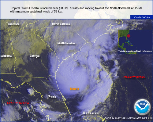
Ernesto developed into a tropical disturbance off the coast of Venezuela on August 24, 2006 and became a tropical storm in the Caribbean on the 25th. Ernesto briefly reached Category 1 hurricane strength on the 27th before weakening over Haiti and Cuba through the 28th. Tropical Storm Ernesto reached the South Florida Coast on the 29th and a hurricane watch was raised for the Carolina Coast as far north as Cape Fear, NC. As Ernesto moved up the Florida Peninsula and weakened to a tropical depression, the hurricane watch was replaced with a tropical storm warning north to Cape Fear. Ernesto moved off the Florida Coast at Cape Canaveral on the morning of August 31 and strengthened to tropical storm strength, and by late morning it was off the Georgia Coast. At that time further strengthening forced a hurricane watch along with the tropical storm warning. Tropical Storm Ernesto made landfall on the coast of Brunswick County, NC near 11:30 pm on August 31. Ernesto moved up the Coastal Plain of North Carolina on September 1, moving into Virginia in the late afternoon.


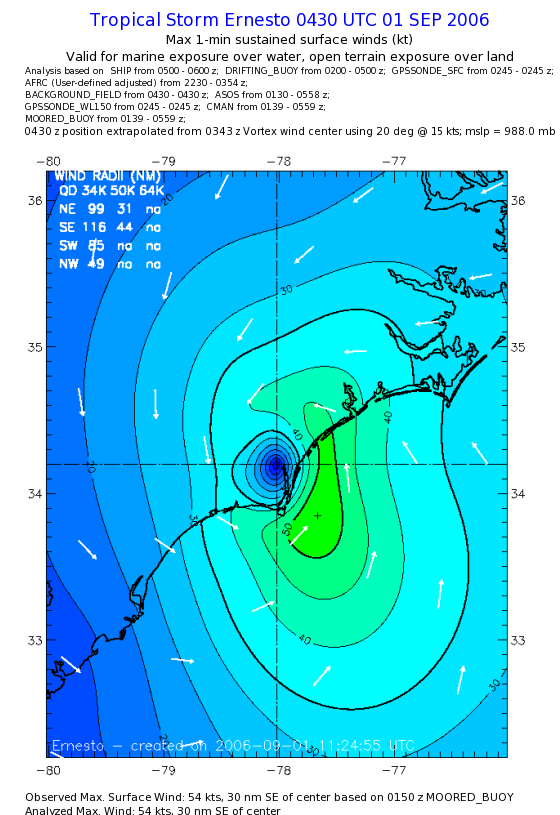
Wind Data (August 31, 2006 - September 1, 2006)

Wilmington, NC - New Hanover County (Wilmington International Airport: ASOS)

Max Sustained: 36 kt/41 mph @ 1135 pm Peak Gust: 54 kt/62 mph @ 1135 pm

Wrightsville Beach, NC - New Hanover County (Johnnie Mercer Pier: NOAA/NOS)

Max Sustained: 50 kt/58 mph @ 1130 pm Peak Gust: 64 kt/74 mph @ 1130 pm

Southport, NC - Brunswick County (Brunswick County Airport: AWOS )

Max Sustained: 23 kt/26 mph @ 840 pm

Peak Gust: 43 kt/49 mph @ 1000 pm

Sunset Beach, NC - Brunswick County (Sunset Beach Pier: NOAA/NOS)

Max Sustained: 32 kt/37 mph @ 900 pm Peak Gust: 43 kt/49 mph @ 900 pm

North Myrtle Beach, SC - Horry County (North Myrtle Beach Airport: ASOS)

Max Sustained: 22 kt/25 mph @ 947 pm Peak Gust: 35 kt/40 mph @ 1058 pm

Myrtle Beach, SC - Horry County (Myrtle Beach International Airport: AWOS)

Max Sustained: 30 kt/35 mph @ 850 pm Peak Gust: 40 kt/46 mph @ 850 pm

Myrtle Beach, SC - Horry County (Springmaid Pier: NOAA/NOS)

Max Sustained: 26 kt/30 mph @ 100 pm Peak Gust: 38 kt/44 mph @ 200 pm
 

Frying Pan Shoals Buoy (NDBC Buoy 41013)

Max Sustained: 45 kt/52 mph @ 850 pm Peak Gust: 56 kt/64 mph @ 850 pm

Edisto Buoy (NDBC Buoy 41004)

Max Sustained: 39 kt/45 mph @ 550 pm Peak Gust: 49 kt/56 mph @ 550 pm

Onslow Bay Buoy (CORMP Buoy 41035)

Max Sustained: 41 kt/47 mph @ 250 am Peak Gust: 52 kt/60 mph @ 250 am
 

Additional Private Sites

NC State Pilot Southport Waterfront, Peak Gust: 59 kt/68 mph

Sunny Point U.S. Army Terminal, Peak Gust: 59 kt/68 mph

Max Sustained Wind Swath

Wind Gusts

Preliminary and Experimental Maximum Sustained Wind Swath, courtesy of HRD

Peak Wind Gusts


Pressure Data (August 31, 2006 - September 1, 2006)

Wilmington, NC - New Hanover County (Wilmington International Airport: ASOS)

Lowest Pressure: 985.4 mb @ 1247 am

Wrightsville Beach, NC - New Hanover County (Johnnie Mercer Pier: NOAA/NOS)

Lowest Pressure: 986.8 mb @ 1237 am

Southport, NC - Brunswick County (Brunswick County Airport: AWOS )

Lowest Pressure: 987.8 mb @ 1140 pm

Sunset Beach, NC - Brunswick County (Sunset Beach Pier: NOAA/NOS)

Lowest Pressure: 991.5 mb @ 1100 pm

Elizabethtown, NC - Bladen County (Curtis L. Brown Jr. Field: AWOS)

Lowest Pressure: 995.9 mb @ 300 am

North Myrtle Beach, SC - Horry County (North Myrtle Beach Airport: ASOS)

Lowest Pressure: 995.9 mb @ 1259 am

Myrtle Beach, SC - Horry County (Myrtle Beach International Airport: AWOS)

Lowest Pressure: 998.3 mb @ 950 pm

Myrtle Beach, SC - Horry County (Springmaid Pier: NOAA/NOS)

Lowest Pressure: 998 mb @ 1000 pm

Whiteville, SC - Columbus County (Columbus County Airport: AWOS)

Lowest Pressure: 997.6 mb @ 139 am

Florence, SC - Florence County (Florence Regional Airport: ASOS)

Lowest Pressure: 1004.7 mb @ 1259 am


Frying Pan Shoals Buoy (NDBC Buoy 41013)

Lowest Pressure: 990.5 mb @ 950 pm

Edisto Buoy (NDBC Buoy 41004)

Lowest Pressure: 995.6 mb@ 350 pm

Onslow Bay Buoy (CORMP Buoy 41035)

Lowest Pressure: 993.6 mb @ 250 am


Storm Total Rainfall (August 31, 2006 - September 1, 2006)

Pender County, NC

Surf City Island Mesonet: 11.92"

Surf City Mainland: 8.61"

Hampstead: 11.13"

Burgaw 3W: 8.60"

Holly Shelter Back Island RAWS: 10.21"


New Hanover County, NC

Parmele Isle Wrightsville Beach: 14.61"

Wilmington Intl. Airport ASOS: 9.64"

Wilmington 7N: 10.31"

UNCW Campus: 9.07"

Wilmington Kings Grant: 9.80"


Brunswick County, NC

Leland: 8.50"

Supply RAWS: 7.29"

Longwood: 7.65"

Sunny Point: 5.18"

Bladen County, NC

East Arcadia: 7.32"

Elizabethtown: 4.38"

Turnbull Creek RAWS: 4.45"


Columbus County, NC

Whiteville 5S: 4.55"

Whiteville RAWS: 4.52"

Robeson County, NC

Red Springs: 2.85"

Lumberton 3S: 2.53"

Lumberton Regional Airport: 2.63"


Horry County, SC

North Myrtle Beach Airport: 7.22"

Socastee: 3.39"

Myrtle Beach FD: 6.30"

Gallivants Ferry: 1.77"

Conway: 4.02"


Florence County, SC

Effingham: 0.70"

Quinby: 0.54"

Florence Regional Airport: 0.62"


Marion County, SC

Mullins: 1.81"

Marion: 1.23"

Dillon County, SC

Dillon: 1.35"


Radar

Radar Loop
Wilmington Radar (KLTX) Loop around landfall

Storm total precipitation
Radar estimated Storm Total Precipitation


Flooding

Pender County: Heavy rains caused widespread ponding and shallow running water swept a few vehicles from roadways. Some roads were closed the next day. Northeast Cape Fear River and creeks rising with flooding expected. Rockfish Creek flooded and swift water rescues were required for a couple of homes. New Hanover, Brunswick and Eastern Columbus Counties: Heavy rain during the early afternoon well before landfall caused widespread ponding and stalled vehicles. Heavy rains later caused more flooding. Many roads were closed, but were mostly open by sunrise. Horry County:As Ernesto made landfall, heavy rains on the west side of the circulation caused ponding on roadways in Eastern Horry County.


Maximum Storm Tide Heights

Ernesto approached Long Bay on the Northeast South Carolina Coast at low tide and caused a surge about 1.5 feet above astronomical. The storm tide was below normal high tide, and there was no coastal flooding. As Ernesto crossed Cape Fear the tide was above half full, and at Wrightsville Beach, NC the surge was nearly 3 feet.


(MLLW=Mean Low Low Water (Feet above average lower low tide)

Oyster Landing, SC (Georgetown County) NOAA/NOS: Maximum Surge 1.73 ft at 754 pm, below normal high tide.

Sunset Beach Pier, NC (NC/SC State Line) NOAA/NOS: Maximum Surge 1.58 ft at 812 pm, below normal high tide.    

Wrightsville Beach, NC (Johnnie Mercer Pier) NOAA/NOS: Maximum Tide Level 5.87 ft at 1136 pm...Maximum Surge 2.9 ft at 1118 am.


Beach Erosion

Reports of minor beach erosion north of Cape Fear.


Tornadoes

None.


Storm Effects

Minor power outages in Southeast North Carolina.


Deaths or Injuries

None reported.