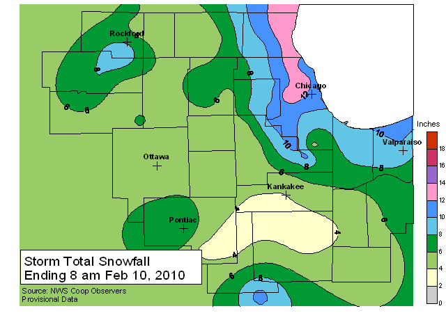
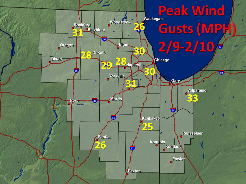
A record-breaking snow storm occurred across much of the Midwest on February 8th-10th, 2010. Snow began to overspread the area late in the evening on Monday, February 8th, and continued until the early morning hours on Wednesday, February 10th. By the time the snow came to an end, snow totals across the area ranged from 3-5 inches across the southwestern portion of the forecast area, to over a foot in the counties near Lake Michigan, where the lake helped to influence snowfall rates Tuesday evening. In addition to heavy snowfall, northwest winds gusted to between 25 and 35 miles per hour at times late Tuesday night and Wednesday morning, resulting in significant blowing and drifting snow.
The 12.6" of snow that fell between 12:01 AM and 11:59 PM on February 8th at O'Hare International Airport shattered the old daily record of 8.9 inches that was set back in 1885. The 12.6" of snow also becomes the highest single daily total in the month of February for Chicago since records started being kept.
Below is a map of snow totals across the area. The highest snow totals occurred close to Lake Michigan, where snow became lake enhanced Tuesday evening, resulting in snowfall rates of 1+" per hour at times.
 |
| Beach Park | 14.0 |
| Melrose Park | 14.0 |
| Northbrook | 13.2 |
| O'Hare | 12.9 |
| Park Ridge 1NNE | 12.9 |
| Gurnee 2W | 12.5 |
| La Grange | 11.6 |
| Chicago Botanic Gardens | 11.0 |
| Frankfort | 11.0 |
| Paxton | 11.0 |
| Willowbrook | 11.0 |
| Monee | 10.8 |
| Valparaiso 5NNE, IN | 10.2 |
| Oak Brook | 10.1 |
| Elk Grove Village | 10.0 |
| Midway 3SW | 9.8 |
| Mundelein | 9.4 |
| Highland, IN | 9.0 |
| Lake Zurich | 9.0 |
| Spring Grove | 9.0 |
| Wauconda | 9.0 |
| McHenry | 8.3 |
| Barrington 3SW | 8.0 |
| Naperville | 8.0 |
| Oregon | 8.0 |
| Wanatah, IN | 8.0 |
| Winfield | 8.0 |
| Streamwood | 7.8 |
| Lowell, IN | 7.5 |
| NWS Office Romeoville | 7.2 |
| Peotone | 7.2 |
| Rockford 4NNW | 7.0 |
| RFD | 6.9 |
| St. Charles 7NW | 6.8 |
| Elgin | 6.7 |
| Paw Paw | 6.5 |
| Rensselaer, IN | 6.2 |
| Streator | 6.0 |
| Morris | 5.7 |
| Woodstock | 5.5 |
| DeKalb | 5.4 |
| Peru | 5.3 |
| Park Forest | 5.2 |
| Dwight | 5.0 |
| Joliet Lock/Dam | 5.0 |
| Marengo | 5.0 |
| Mendota | 5.0 |
| Ottawa 4SW | 5.0 |
| Plainfield | 5.0 |
| Coal City 4NNW | 4.9 |
| Marseilles | 4.9 |
| Batavia | 4.8 |
| Yorkville 2SE | 4.8 |
| Lake Village, IN | 4.7 |
| Remington, IN | 4.6 |
| Roscoe | 4.5 |
| Steward | 4.5 |
| Woodstock 5NW | 4.5 |
| Plano | 4.3 |
| Milford 5NW | 4.2 |
| Newark 2SSE | 4.2 |
| Bourbonnais | 4.1 |
| Kankakee | 4.0 |
| Rochelle | 4.0 |
| St. Anne | 4.0 |
| Herscher | 3.7 |
| Fairbury | 3.6 |
| Chatsworth | 3.0 |
| Watseka | 3.0 |
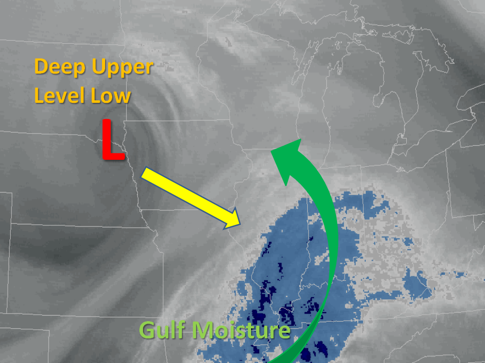
The snow occurred in response to a strong upper level area of low pressure that dropped south from Canada over the previous weekend. This Canadian low merged with a weaker trough moving east from the southern Rocky Mountains, with moisture from the Gulf of Mexico surging north ahead of this system. The lift from this strong upper low combined with the Gulf moisture, resulting in a prolonged period of snow across the area.
 |
In addition to the heavy snow, northwest winds increased Tuesday night and Wednesday morning as a deep surface low strengthened across Ohio. These gusty northwest winds resulted in significant blowing and drifting snow across much of the area, making snow removal efforts very difficult Wednesday morning.
 |

