|
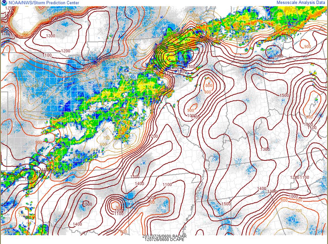
Late Wednesday night into early Thursday morning brought thunderstorms developing eastward into northern Illinois. Rich atmospheric moisture along with sufficient wind shear and instability presented a scattered severe thunderstorm threat, namely strong winds at the surface. One ingredient favorable for downburst winds was that the lower atmosphere remained well-mixed despite the overnight time. This ensured downdrafts from thunderstorm cloud bases would be stronger, rushing downward and surging outward at a greater speed than normal. To the right is a regional radar image with a model analysis of downdraft CAPE overlaid. Very high values indicative of strong downdraft potential were present across the region. For more about downdraft CAPE and how it relates to a downburst wind threat, see here. |
|
Below is a listing of the severe weather reports received on early Thursday morning. The reports in Winnebago and Boone Counties were from rain-cooled outflow which had rushed out from storms in eastern Iowa, far northwest Illinois, and southern Wisconsin. This again could be attributed to the well-mixed state of the lower atmosphere ahead of the storms. Also on the list of reports is a 70 mph gust measured at O'Hare International Airport, which was due to an individual storm downburst.
PRELIMINARY LOCAL STORM REPORT...CORRECTED
NATIONAL WEATHER SERVICE CHICAGO/ROMEOVILLE IL
910 AM CDT THU JUL 26 2012

..TIME...   ...EVENT...      ...CITY LOCATION...     ...LAT.LON...
..DATE...   ....MAG....      ..COUNTY LOCATION..ST.. ...SOURCE....
            ..REMARKS..

1239 AM     NON-TSTM WND GST WINNEBAGO               42.27N 89.24W
07/26/2012  E60.00 MPH       WINNEBAGO          IL   BROADCAST MEDIA

            TREES BENDING. AT WREX-TV STATION.

1253 AM     NON-TSTM WND GST SOUTH BELOIT            42.48N 89.03W
07/26/2012  E60.00 MPH       WINNEBAGO          IL   TRAINED SPOTTER

            SMALL TO MEDIUM LIMBS BLOWN AROUND.

0107 AM     NON-TSTM WND GST BELVIDERE               42.25N 88.85W
07/26/2012  E55.00 MPH       BOONE              IL   TRAINED SPOTTER

            RELAYED BY WREX-TV.

0139 AM     TSTM WND GST     OHARE AIRPORT           41.98N 87.90W
07/26/2012  M70.00 MPH       COOK               IL   ASOS

0310 AM     MARINE TSTM WIND 4 NE TOWN OF PINES      41.73N 86.91W
07/26/2012  M57.00 MPH       PORTER             IN   C-MAN STATION


&&

$$
Radar Imagery
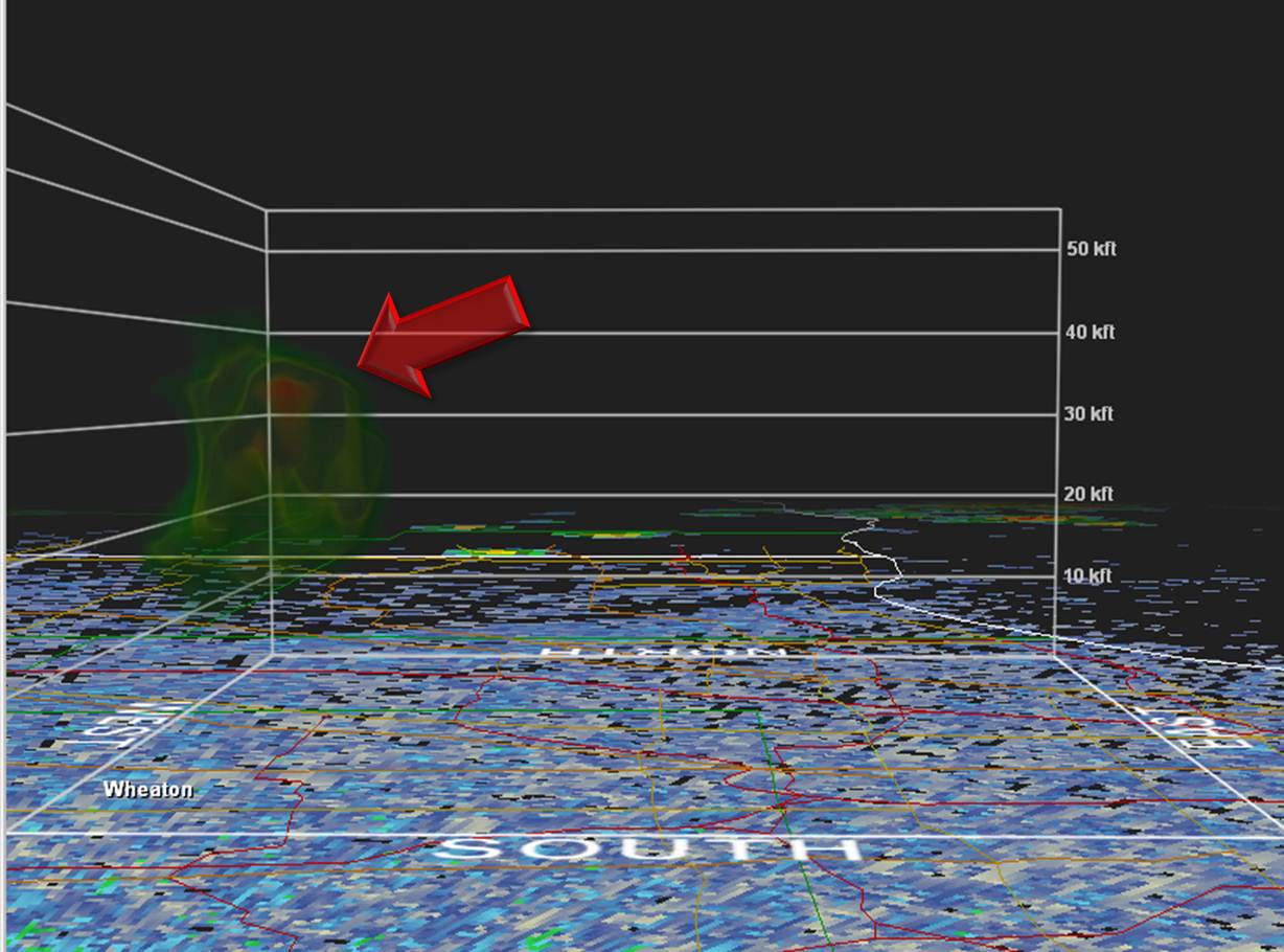
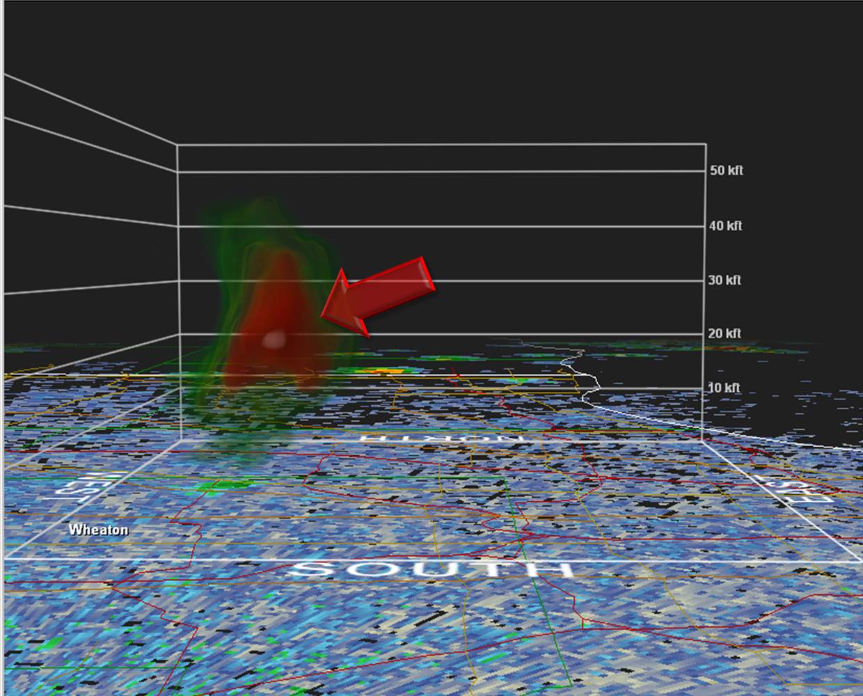
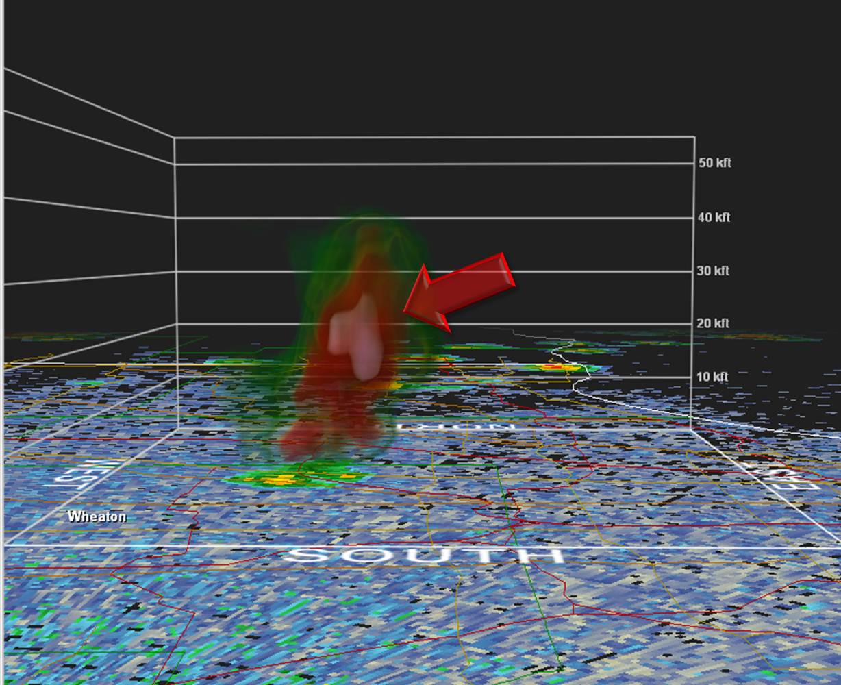
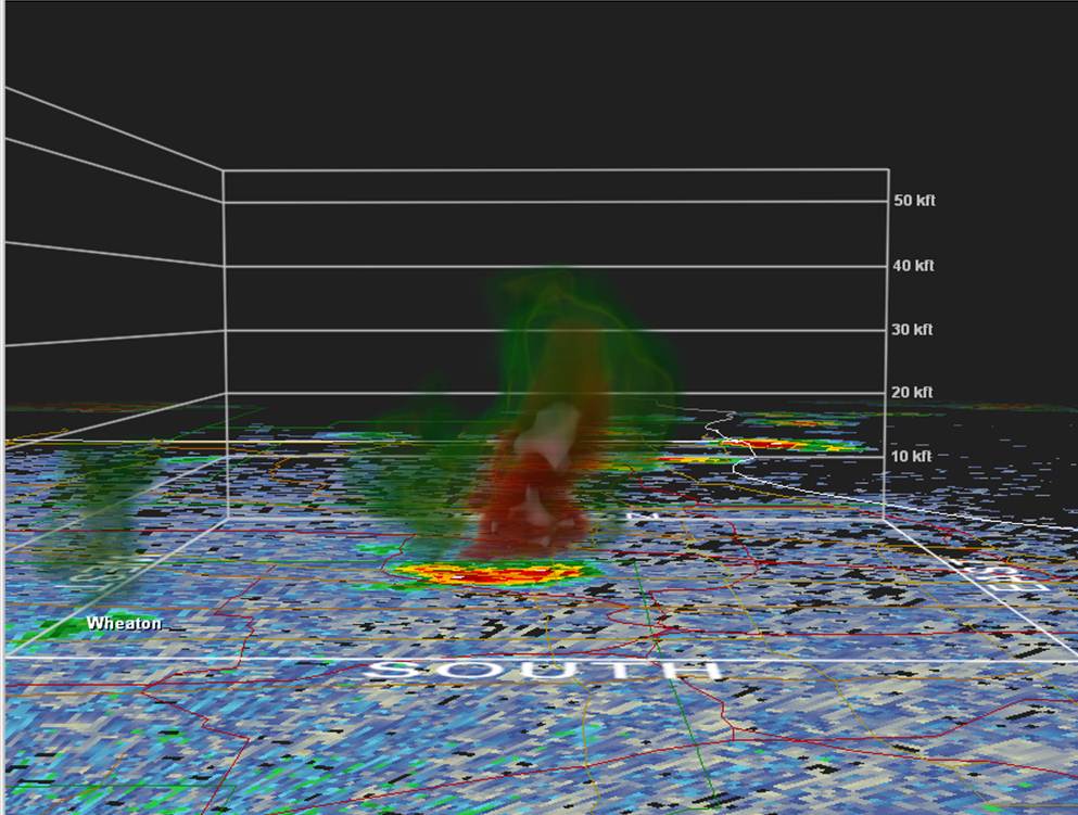
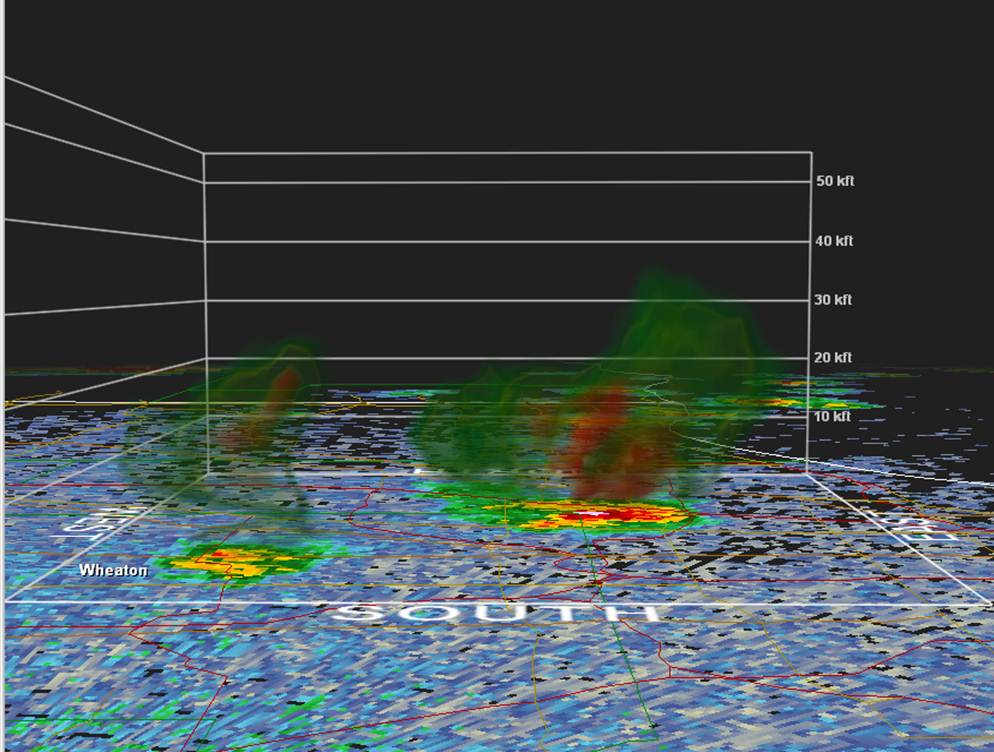
Below is three-dimensional radar reflectivity imagery from KLOT of the storm that quickly developed, and just as rapidly descended over O'Hare International Airport between 1:20 and 1:40 am. The quick descent of the strong reflectivity within the storm is a direct measurement of the storm's precipitation core racing downward. The core was between 60 and 65 dBZ in intensity and roughly 10,000 ft deep. The center of this highest reflectivity descended approximately 20,000 ft in ten minutes based on the radar imagery. The point where it reached the ground happened to be right over the airport. Water loading of the core due to such rich moisture, and then some degree of evaporational cooling below the cloud base, created the 70 mph observed gust as the core neared and reached the ground. Radar interpretation combined with environmental analysis allows for warning forecasters to detect these type of threats, and aided in the issuance of a severe thunderstorm warning prior to this core collapse.
|
3-D Radar Image: 1:21 am |
|
|
|
3-D Radar Image: 1:25 am |
|
|
|
3-D Radar Image: 1:29 am |
|
|
|
3-D Radar Image: 1:34 am |
|
|
|
3-D Radar Image: 1:40 am |
|
|
Images were created within the GR2Analyst Program.